Low pressure developing over the western Caribbean Sea (Is Invest 97L)

This is the general tropical discussion area. Anyone can take their shot at predicting a storms path.

Moderator: S2k Moderators

Forum rules

The posts in this forum are NOT official forecasts and should not be used as such. They are just the opinion of the poster and may or may not be backed by sound meteorological data. They are NOT endorsed by any professional institution or STORM2K. For official information, please refer to products from the National Hurricane Center and National Weather Service.

Help Support Storm2K
Message
Author
User avatar
eastcoastFL
Category 5
Category 5
Posts: 3901
Age: 43
Joined: Thu Apr 12, 2007 12:29 pm
Location: Palm City, FL

Re: Area of low pressure to develop over the western Caribbean sea (0/50)

#721 Postby eastcoastFL » Fri Sep 20, 2024 6:56 pm

jfk08c wrote:https://i.imgur.com/0LzllYt.png

Yet another reason to always look at ensemble means when looking further than 4 days out. Tends to outperform most all of the time


What exactly am I looking at here?
0 likes   
Personal Forecast Disclaimer:
The posts in this forum are NOT official forecast and should not be used as such. They are just the opinion of the poster and may or may not be backed by sound meteorological data. They are NOT endorsed by any professional institution or storm2k.org. For official information, please refer to the NHC and NWS products.

Frank P
S2K Supporter
S2K Supporter
Posts: 2776
Joined: Fri Aug 29, 2003 10:52 am
Location: Biloxi Beach, Ms
Contact:

Re: Area of low pressure to develop over the western Caribbean sea (0/60)

#722 Postby Frank P » Fri Sep 20, 2024 7:04 pm

The 12z ECMWF-AIFS model similar to the GFS18z but a tad weaker and faster landfall next Friday
Image
Last edited by Frank P on Fri Sep 20, 2024 7:15 pm, edited 1 time in total.
0 likes   

User avatar
jfk08c
S2K Supporter
S2K Supporter
Posts: 204
Joined: Mon Jun 11, 2018 4:36 pm
Location: Lakeland, FL

Re: Area of low pressure to develop over the western Caribbean sea (0/50)

#723 Postby jfk08c » Fri Sep 20, 2024 7:07 pm

eastcoastFL wrote:
jfk08c wrote:https://i.imgur.com/0LzllYt.png

Yet another reason to always look at ensemble means when looking further than 4 days out. Tends to outperform most all of the time


What exactly am I looking at here?


Basically a graph from the ECMWF user guide that shows anomaly correlation coefficient between different products of the Euro.

Red is Operational runs, purple is control run, green is ensemble mean, and light blue is individual members. You can see the decline in accuracy as the days go out, yet the ensemble mean remains the most accurate product from the model runs 4+ days out
3 likes   

Michele B
S2K Supporter
S2K Supporter
Posts: 1114
Joined: Thu Aug 25, 2016 8:08 am
Location: SWFL

Re: Area of low pressure to develop over the western Caribbean sea (0/50)

#724 Postby Michele B » Fri Sep 20, 2024 8:15 pm

gatorcane wrote:
Weathertracker96 wrote:
DunedinDave wrote:GFS a believer of the “Florida Shield.”


There is no such thing as a Florida Shield when Debby hit this year, Idalia last year and Nicole & Ian in 2022.

Until a center forms, it’s best for all to watch.


From his perspective in the Tampa area, it might feel like there is a shield since it has been over 100 years since that area as seen Major hurricane impacts (1921) not to mention Charley (2004) and Ian (2022) looked like shoe-in Tampa Bay hits yet somehow they hit SW Florida.


It’s not a “shield” for Tampa area as much as it is the very warm waters of the Peace River that “lures” the storms in to SW FL coast.
0 likes   
Cleo - 1964, Betsy - 1965, David - 1979, Andrew - 1992, Charlie (Francis, Ivan, Jeanne) - 2004, Irma - 2017, Ian - 2022

User avatar
Ubuntwo
Category 5
Category 5
Posts: 1406
Age: 31
Joined: Thu Oct 05, 2017 10:41 pm

Re: Area of low pressure to develop over the western Caribbean sea (0/50)

#725 Postby Ubuntwo » Fri Sep 20, 2024 8:23 pm

Michele B wrote:
gatorcane wrote:
Weathertracker96 wrote:
There is no such thing as a Florida Shield when Debby hit this year, Idalia last year and Nicole & Ian in 2022.

Until a center forms, it’s best for all to watch.


From his perspective in the Tampa area, it might feel like there is a shield since it has been over 100 years since that area as seen Major hurricane impacts (1921) not to mention Charley (2004) and Ian (2022) looked like shoe-in Tampa Bay hits yet somehow they hit SW Florida.


It’s not a “shield” for Tampa area as much as it is the very warm waters of the Peace River that “lures” the storms in to SW FL coast.

Water temps do not guide storms, this is another common misconception (although it kinda feels like they should!). It is the angle of the coastline which takes a very delicate troughing setup to directly strike.
8 likes   
Kendall -> SLO -> PBC

Memorable Storms: Katrina (for its Florida landfall...) Wilma Matthew Irma

User avatar
Spacecoast
Category 2
Category 2
Posts: 758
Joined: Thu Aug 31, 2017 2:03 pm

Re: Area of low pressure to develop over the western Caribbean sea (0/50)

#726 Postby Spacecoast » Fri Sep 20, 2024 8:38 pm

jfk08c wrote:
eastcoastFL wrote:
jfk08c wrote:https://i.imgur.com/0LzllYt.png

Red is Operational runs, purple is control run, green is ensemble mean, and light blue is individual members. You can see the decline in accuracy as the days go out, yet the ensemble mean remains the most accurate product from the model runs 4+ days out


Absolutely.
Unfortunately , TT, and Weathernerds do not output ensemble means, just the individual members. Most S2K posts do not show control member, or the mean tracks.
This requires the user to 'visualize', or imagine where the mean track really is, and whether more members are east, or west of a given location
Once the storm gets invested, TT starts displaying on it's current storm page, and weathernerds displays mean track on it's TC Guidance page.

One situation where the Ensemble mean may be less accurate is 'fork in the road' bifurcation. i.e 50% go west, 50% go east, and 0% go north. The mean track would be inaccurate in this case.

My order of accuracy is
1. NHC track (once available)
2. Consensus of operational (or an 'ensemble' of operationals) like TVCN,etc
3. Consensus of Ensemble means, or super-ensemble mean. (Tomer Burg used to generate these). I Think FSSU also.
4. Ensemble means (EEMN, AEMN, CEMN).

Most of these are difficult to find until invest time.
2 likes   

User avatar
Blown Away
S2K Supporter
S2K Supporter
Posts: 10145
Joined: Wed May 26, 2004 6:17 am

Re: Area of low pressure to develop over the western Caribbean sea (0/60)

#727 Postby Blown Away » Fri Sep 20, 2024 8:45 pm

Image

18z GEFS… Lots of uncertainty…
3 likes   
Hurricane Eye Experience: David 79, Irene 99, Frances 04, Jeanne 04, Wilma 05... EYE COMING MY WAY IN 2024…
Hurricane Brush Experience: Andrew 92, Erin 95, Floyd 99, Matthew 16, Irma 17, Ian 22, Nicole 22…

User avatar
AtlanticWind
S2K Supporter
S2K Supporter
Posts: 1889
Age: 66
Joined: Sun Aug 08, 2004 9:57 pm
Location: Plantation,Fla

Re: Area of low pressure to develop over the western Caribbean sea (0/60)

#728 Postby AtlanticWind » Fri Sep 20, 2024 8:47 pm

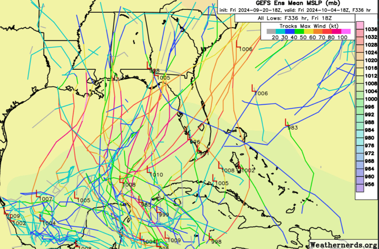
Blown Away wrote:[url]https://i.postimg.cc/W3pgTT9L/IMG-0243.jpg [/url]

18z GEFS… Lots of uncertainty…

You don’t get much more uncertain than that
4 likes   

User avatar
Blown Away
S2K Supporter
S2K Supporter
Posts: 10145
Joined: Wed May 26, 2004 6:17 am

Re: Area of low pressure to develop over the western Caribbean sea (0/60)

#729 Postby Blown Away » Fri Sep 20, 2024 8:51 pm

Image

GEFS trending back E today…
4 likes   
Hurricane Eye Experience: David 79, Irene 99, Frances 04, Jeanne 04, Wilma 05... EYE COMING MY WAY IN 2024…
Hurricane Brush Experience: Andrew 92, Erin 95, Floyd 99, Matthew 16, Irma 17, Ian 22, Nicole 22…

LAF92
Tropical Depression
Tropical Depression
Posts: 51
Joined: Fri Aug 18, 2023 6:27 pm

Re: Area of low pressure to develop over the western Caribbean sea (0/60)

#730 Postby LAF92 » Fri Sep 20, 2024 9:02 pm

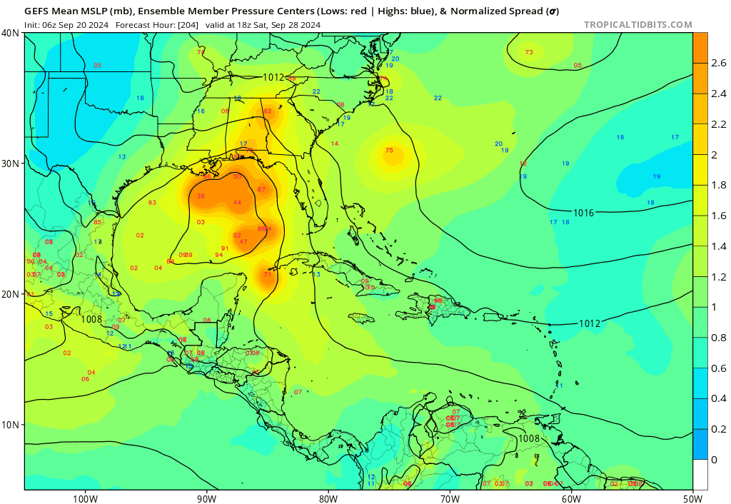
Blown Away wrote:[url]https://i.postimg.cc/BvttgpnD/gfs-ememb-lowlocs-watl-fh192-trend.gif [/url]

GEFS trending back E today…

To me it just shows more uncertainty than ever before
0 likes   

floridasun
Tropical Storm
Tropical Storm
Posts: 203
Joined: Tue Sep 14, 2021 3:59 pm

Re: Area of low pressure to develop over the western Caribbean sea (0/60)

#731 Postby floridasun » Fri Sep 20, 2024 9:04 pm

have notice that upper low over florida causing some shear over northern part of Caribbean
0 likes   

User avatar
Blown Away
S2K Supporter
S2K Supporter
Posts: 10145
Joined: Wed May 26, 2004 6:17 am

Re: Area of low pressure to develop over the western Caribbean sea (0/60)

#732 Postby Blown Away » Fri Sep 20, 2024 9:07 pm

Image

NHC’s development area is leaning left and most of the GEFS are right…
3 likes   
Hurricane Eye Experience: David 79, Irene 99, Frances 04, Jeanne 04, Wilma 05... EYE COMING MY WAY IN 2024…
Hurricane Brush Experience: Andrew 92, Erin 95, Floyd 99, Matthew 16, Irma 17, Ian 22, Nicole 22…

sphelps8681
Category 2
Category 2
Posts: 785
Joined: Thu Aug 16, 2007 5:37 pm
Location: Somewhere over the rainbow

Re: Area of low pressure to develop over the western Caribbean sea (0/60)

#733 Postby sphelps8681 » Fri Sep 20, 2024 9:09 pm

I guess we can say they can trend all day long one way or another. And then do the flip flopping all around. But we still don't have a center yet. No models to me should be correct until a center forms. Correct me if I am wrong. This is what I always hear. Hyping one area or another does not help anyone at this point. It could literally be a Nothing-Burger. We all need to be patient. To many on here that depend on the things that are said to be prepared are looking for accurate information. Not something that could or would have. From Texas to Florida is all in play at this point.
3 likes   

SconnieCane
Category 4
Category 4
Posts: 998
Joined: Thu Aug 02, 2018 5:29 pm
Location: Madison, WI

Re: Area of low pressure to develop over the western Caribbean sea (0/60)

#734 Postby SconnieCane » Fri Sep 20, 2024 9:14 pm

Have we set a record for the longest pre-invest thread, yet? How about the longest for one where the 48-hour development chances are still "near 0 percent"? :lol: :roll: :oops:
3 likes   

User avatar
Spacecoast
Category 2
Category 2
Posts: 758
Joined: Thu Aug 31, 2017 2:03 pm

Re: Area of low pressure to develop over the western Caribbean sea (0/60)

#735 Postby Spacecoast » Fri Sep 20, 2024 9:16 pm

Formation chance through 48 hours...low...near 0 percent.
I would say 2 percent. :lol:
Image
1 likes   

User avatar
Ubuntwo
Category 5
Category 5
Posts: 1406
Age: 31
Joined: Thu Oct 05, 2017 10:41 pm

Re: Area of low pressure to develop over the western Caribbean sea (0/60)

#736 Postby Ubuntwo » Fri Sep 20, 2024 9:17 pm

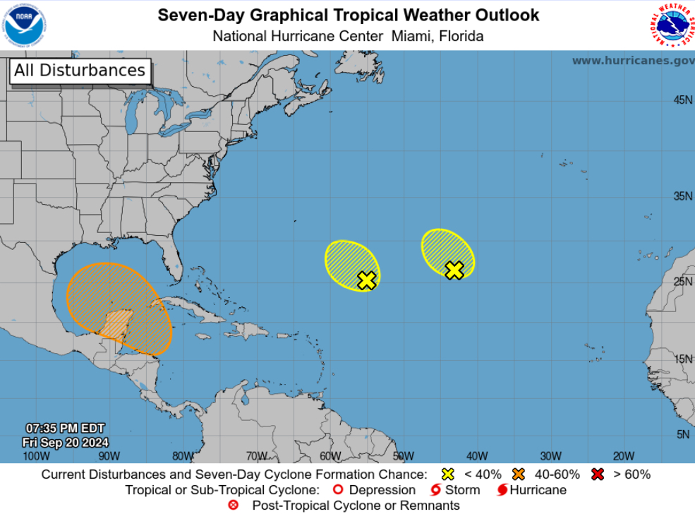
Blown Away wrote:[url]https://i.postimg.cc/KzLhN3Sx/IMG-0245.jpg [/url]

NHC’s development area is leaning left and most of the GEFS are right…

It’s the possible development area, not track. If it is as far east as peninsular Florida, it will have developed in the western Caribbean vs the Gulf.
1 likes   
Kendall -> SLO -> PBC

Memorable Storms: Katrina (for its Florida landfall...) Wilma Matthew Irma

User avatar
Ubuntwo
Category 5
Category 5
Posts: 1406
Age: 31
Joined: Thu Oct 05, 2017 10:41 pm

Re: Area of low pressure to develop over the western Caribbean sea (0/60)

#737 Postby Ubuntwo » Fri Sep 20, 2024 9:18 pm

SconnieCane wrote:Have we set a record for the longest pre-invest thread, yet? How about the longest for one where the 48-hour development chances are still "near 0 percent"? :lol: :roll: :oops:

To be expected now that the NHC outlooks go out to 7 days instead of 5.
2 likes   
Kendall -> SLO -> PBC

Memorable Storms: Katrina (for its Florida landfall...) Wilma Matthew Irma

User avatar
cycloneye
Admin
Admin
Posts: 145322
Age: 68
Joined: Thu Oct 10, 2002 10:54 am
Location: San Juan, Puerto Rico

Re: Area of low pressure to develop over the western Caribbean sea (0/60)

#738 Postby cycloneye » Fri Sep 20, 2024 9:35 pm

SconnieCane wrote:Have we set a record for the longest pre-invest thread, yet? How about the longest for one where the 48-hour development chances are still "near 0 percent"? :lol: :roll: :oops:


Closing in on the record 1075 posts from the pre Francine thread.
2 likes   
Visit the Caribbean-Central America Weather Thread where you can find at first post web cams,radars
and observations from Caribbean basin members Click Here

User avatar
Ubuntwo
Category 5
Category 5
Posts: 1406
Age: 31
Joined: Thu Oct 05, 2017 10:41 pm

Re: Area of low pressure to develop over the western Caribbean sea (0/60)

#739 Postby Ubuntwo » Fri Sep 20, 2024 9:53 pm

All but 2 members of the 12z Euro ensemble develop. That's 96% developing. The spread is colossal and about as wide as I've seen for a storm this (relatively) close to development. From a broad, whole gyre type TS to compact major hurricanes, and tracks buried in the Bay of Campeche to quickly curving through South Florida.
3 likes   
Kendall -> SLO -> PBC

Memorable Storms: Katrina (for its Florida landfall...) Wilma Matthew Irma

User avatar
Steve
S2K Supporter
S2K Supporter
Posts: 9621
Joined: Sat Apr 05, 2003 11:41 pm
Location: Not a state-caster

Re: Area of low pressure to develop over the western Caribbean sea (0/60)

#740 Postby Steve » Fri Sep 20, 2024 10:35 pm

ICON looking like a higher end Cat 2 maybe headed to Alabama or NWFL at 180 hours. Upper 960’s and room to deepen though I haven’t looked at 500 yet.

https://www.pivotalweather.com/model.ph ... &dpdt=&mc=
0 likes   


Return to “Talkin' Tropics”

Who is online

Users browsing this forum: Blown Away, Google Adsense [Bot], johngaltfla, JtSmarts, lilbump3000, RomP, Steve H., Ulf and 55 guests