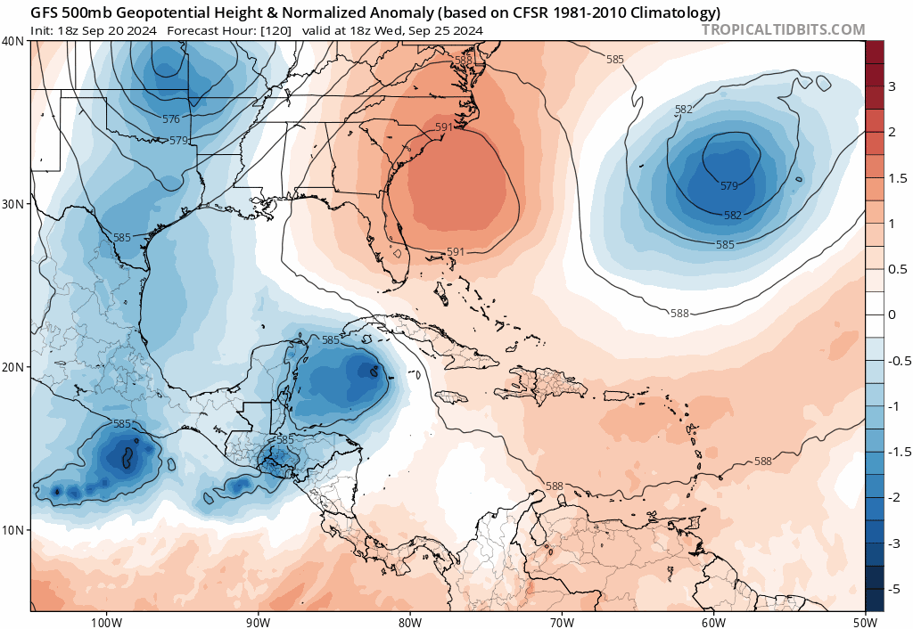
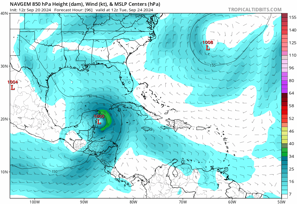
Low pressure developing over the western Caribbean Sea (Is Invest 97L)

This is the general tropical discussion area. Anyone can take their shot at predicting a storms path.

Moderator: S2k Moderators

Forum rules

The posts in this forum are NOT official forecasts and should not be used as such. They are just the opinion of the poster and may or may not be backed by sound meteorological data. They are NOT endorsed by any professional institution or STORM2K. For official information, please refer to products from the National Hurricane Center and National Weather Service.

Help Support Storm2K
Message
Author
DunedinDave
Tropical Storm
Tropical Storm
Posts: 227
Joined: Fri Aug 25, 2023 10:31 am

Re: Area of low pressure to develop over the western Caribbean sea (0/50)

#701 Postby DunedinDave » Fri Sep 20, 2024 6:11 pm

gatorcane wrote:
Weathertracker96 wrote:
DunedinDave wrote:GFS a believer of the “Florida Shield.”


There is no such thing as a Florida Shield when Debby hit this year, Idalia last year and Nicole & Ian in 2022.

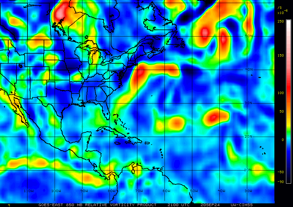
Until a center forms, it’s best for all to watch.


From his perspective in the Tampa area, it might feel like there is a shield since it has been over 100 years since that area as seen Major hurricane impacts (1921) not to mention Charley (2004) and Ian (2022) looked like shoe-in Tampa Bay hits yet somehow they hit SW Florida.


Yeah I’m not saying there will be a gauranteed “shield” for this system…just that the models as of now have it that way. And a few posters seem to be writing off Florida as well and saying it’s northern gulf coast bound. For the record, I think it’s way too premature for saying such things.
1 likes   

User avatar
jfk08c
S2K Supporter
S2K Supporter
Posts: 204
Joined: Mon Jun 11, 2018 4:36 pm
Location: Lakeland, FL

Re: Area of low pressure to develop over the western Caribbean sea (0/50)

#702 Postby jfk08c » Fri Sep 20, 2024 6:12 pm

Looking at the GFS ensembles, it seems like the members slower to get North feel a breakdown in the ridge to the east and get pulled through by an area of low pressure in the Western Atlantic. That would pull it across the peninsula instead of up into the Northern GoM
1 likes   

Weathertracker96
Tropical Storm
Tropical Storm
Posts: 104
Joined: Mon Oct 16, 2023 3:41 pm

Re: Area of low pressure to develop over the western Caribbean sea (0/50)

#703 Postby Weathertracker96 » Fri Sep 20, 2024 6:15 pm

Do the ensembles get the same data as operational?
The 18z GEFS seem more east than the last run. Sorry if this question was asked before.
0 likes   

User avatar
gatorcane
S2K Supporter
S2K Supporter
Posts: 23691
Age: 47
Joined: Sun Mar 13, 2005 3:54 pm
Location: Boca Raton, FL

Re: Area of low pressure to develop over the western Caribbean sea (0/50)

#704 Postby gatorcane » Fri Sep 20, 2024 6:20 pm

jfk08c wrote:Looking at the GFS ensembles, it seems like the members slower to get North feel a breakdown in the ridge to the east and get pulled through by an area of low pressure in the Western Atlantic. That would pull it across the peninsula instead of up into the Northern GoM

Indeed the GFS ensembles (mean of all of the ensembes) definitely are breaking that ridge down over the SE US and Florida (the big light red area) much faster than the op GFS so many ensembles turn the system NE into the FL peninsula. Compare the 120-192 hour 500MB chart animations:

GFS:
Image

GFS Ensembles:
Image
Last edited by gatorcane on Fri Sep 20, 2024 6:24 pm, edited 1 time in total.
1 likes   

User avatar
StPeteMike
Category 2
Category 2
Posts: 631
Joined: Thu Jun 07, 2018 11:26 pm

Re: Area of low pressure to develop over the western Caribbean sea (0/50)

#705 Postby StPeteMike » Fri Sep 20, 2024 6:22 pm

Weathertracker96 wrote:Do the ensembles get the same data as operational?
The 18z GEFS seem more east than the last run. Sorry if this question was asked before.

Interested in this as well.
0 likes   
The above post is not official and should not be used as such. It is the opinion of the poster and may or may not be backed by sound meteorological data. It is not endorsed by any professional institution or storm2k.org. For official information, please refer to the NHC and NWS products.

User avatar
jfk08c
S2K Supporter
S2K Supporter
Posts: 204
Joined: Mon Jun 11, 2018 4:36 pm
Location: Lakeland, FL

Re: Area of low pressure to develop over the western Caribbean sea (0/50)

#706 Postby jfk08c » Fri Sep 20, 2024 6:26 pm

StPeteMike wrote:
Weathertracker96 wrote:Do the ensembles get the same data as operational?
The 18z GEFS seem more east than the last run. Sorry if this question was asked before.

Interested in this as well.


They use the same data but tweak initial states to provide a better view of possibilities concerning the atmosphere
2 likes   

Weathertracker96
Tropical Storm
Tropical Storm
Posts: 104
Joined: Mon Oct 16, 2023 3:41 pm

Re: Area of low pressure to develop over the western Caribbean sea (0/50)

#707 Postby Weathertracker96 » Fri Sep 20, 2024 6:28 pm

jfk08c wrote:
StPeteMike wrote:
Weathertracker96 wrote:Do the ensembles get the same data as operational?
The 18z GEFS seem more east than the last run. Sorry if this question was asked before.

Interested in this as well.


They use the same data but tweak initial states to provide a better view of possibilities concerning the atmosphere


Thank you for answering. I was expecting a few ensembles to go east but didn’t expect for them to paint FL peninsula orange. I guess it’s best to continue watching until we get a center
0 likes   

floridasun
Tropical Storm
Tropical Storm
Posts: 203
Joined: Tue Sep 14, 2021 3:59 pm

Re: Area of low pressure to develop over the western Caribbean sea (0/50)

#708 Postby floridasun » Fri Sep 20, 2024 6:31 pm

i looking sat pic this evening their two area to watch north of Honduras and north of Panama i see low both area i notice some of you saw one north of Honduras here sat pic
0 likes   

User avatar
gatorcane
S2K Supporter
S2K Supporter
Posts: 23691
Age: 47
Joined: Sun Mar 13, 2005 3:54 pm
Location: Boca Raton, FL

Re: Area of low pressure to develop over the western Caribbean sea (0/50)

#709 Postby gatorcane » Fri Sep 20, 2024 6:32 pm

Trend for EC-AIFS (last 5 runs). Seems to be locking into the North-Central GOM:

Image
0 likes   

User avatar
MetroMike
Category 4
Category 4
Posts: 952
Joined: Sun Aug 29, 2004 8:13 pm
Location: Tampa Bay
Contact:

Re: Area of low pressure to develop over the western Caribbean sea (0/50)

#710 Postby MetroMike » Fri Sep 20, 2024 6:33 pm

Can't help but notice there is another MH forming in the Caribbean trying to follow somewhat.
It will probably be gone at 0z run.
0 likes   

User avatar
Spacecoast
Category 2
Category 2
Posts: 758
Joined: Thu Aug 31, 2017 2:03 pm

Re: Area of low pressure to develop over the western Caribbean sea (0/50)

#711 Postby Spacecoast » Fri Sep 20, 2024 6:33 pm

gatorcane wrote:
jfk08c wrote:Looking at the GFS ensembles, it seems like the members slower to get North feel a breakdown in the ridge to the east and get pulled through by an area of low pressure in the Western Atlantic. That would pull it across the peninsula instead of up into the Northern GoM

Indeed the GFS ensembles (mean of all of the ensembes) definitely are breaking that ridge down over the SE US and Florida (the big light red area) much faster than the op GFS so many ensembles turn the system NE into the FL peninsula. Compare the 120-192 hour 500MB chart animations:

GFS:
https://i.postimg.cc/VNjSbWW1/gfs-z500a-Norm-watl-fh120-192.gif

GFS Ensembles:
https://i.postimg.cc/zBZnsf0D/gfs-ens-z500a-Norm-watl-fh120-192.gif

Yes, the GEFS ensemble mean (AEMN) is east of the operational, and goes to Big Bend area, rather than Mobile.
I really wish Tomer Burg's site was up, as it always provided super-ensembles, and ensemble means (AEMN,EEMN, & CEMN).
2 likes   

User avatar
toad strangler
S2K Supporter
S2K Supporter
Posts: 4543
Joined: Sun Jul 28, 2013 3:09 pm
Location: Earth
Contact:

Re: Area of low pressure to develop over the western Caribbean sea (0/50)

#712 Postby toad strangler » Fri Sep 20, 2024 6:34 pm

GEFS once again with a significant presence in Florida, including the peninsula at odds with the OP. Without a real disturbance take with a grain of salt. Just like with all the OPS. I don’t believe in any trends or caves or any of that stuff until there’s a real disturbance to hone in on.
2 likes   

User avatar
jfk08c
S2K Supporter
S2K Supporter
Posts: 204
Joined: Mon Jun 11, 2018 4:36 pm
Location: Lakeland, FL

Re: Area of low pressure to develop over the western Caribbean sea (0/50)

#713 Postby jfk08c » Fri Sep 20, 2024 6:36 pm

Image

Yet another reason to always look at ensemble means when looking further than 4 days out. Tends to outperform most all of the time
3 likes   

User avatar
gatorcane
S2K Supporter
S2K Supporter
Posts: 23691
Age: 47
Joined: Sun Mar 13, 2005 3:54 pm
Location: Boca Raton, FL

Re: Area of low pressure to develop over the western Caribbean sea (0/60)

#714 Postby gatorcane » Fri Sep 20, 2024 6:41 pm

Wonder if the GFS and other models have a handle on the current state of the 850MB vorticity. Looks alot stronger than the 18Z GFS initialized with:

Image
4 likes   

Stratton23
Category 5
Category 5
Posts: 2520
Joined: Fri Jul 21, 2023 10:59 pm
Location: Katy, Tx

Re: Area of low pressure to develop over the western Caribbean sea (0/60)

#715 Postby Stratton23 » Fri Sep 20, 2024 6:42 pm

Still a significant spread in the 18z GEFS, with some members still being slower and end up more west, until we get even somewhat of an agreement on the upper air pattern, uncertainty is extremely high
1 likes   

User avatar
eastcoastFL
Category 5
Category 5
Posts: 3901
Age: 43
Joined: Thu Apr 12, 2007 12:29 pm
Location: Palm City, FL

Re: Area of low pressure to develop over the western Caribbean sea (0/50)

#716 Postby eastcoastFL » Fri Sep 20, 2024 6:43 pm

mcheer23 wrote:
cheezyWXguy wrote:
gatorcane wrote:12Z NAVGEM, think it is a bit too far to the left but yikes, CAT 4:

https://i.postimg.cc/9fZ5278S/navgem-mslp-uv850-watl-fh96-180.gif

That might be the strongest storm I’ve ever seen the NAVGEM model. Good thing it’s terrible. On a similar note, a recent run of the Korean model has a cat5 a bit south of there. No idea if that model is any good but seems too extreme either way.


KMA has back to back Cat 5 runs.


Where does it have the storm heading ?
0 likes   
Personal Forecast Disclaimer:
The posts in this forum are NOT official forecast and should not be used as such. They are just the opinion of the poster and may or may not be backed by sound meteorological data. They are NOT endorsed by any professional institution or storm2k.org. For official information, please refer to the NHC and NWS products.

User avatar
jfk08c
S2K Supporter
S2K Supporter
Posts: 204
Joined: Mon Jun 11, 2018 4:36 pm
Location: Lakeland, FL

Re: Area of low pressure to develop over the western Caribbean sea (0/60)

#717 Postby jfk08c » Fri Sep 20, 2024 6:44 pm

Image

GFS seems to think CAG season is open for business, just in time for October
0 likes   

Stormlover70
Tropical Storm
Tropical Storm
Posts: 175
Age: 55
Joined: Fri Jun 21, 2024 5:31 am
Location: New port richey

Re: Area of low pressure to develop over the western Caribbean sea (0/60)

#718 Postby Stormlover70 » Fri Sep 20, 2024 6:47 pm

The system that is supposed to pull this north eventually is east of Alaska. Models are worthless at this juncture. Pretend the Gulf is a dartboard and close your eyes. And shoot.
2 likes   

User avatar
tropicwatch
Category 5
Category 5
Posts: 3383
Age: 61
Joined: Sat Jun 02, 2007 10:01 am
Location: Panama City Florida
Contact:

Re: Area of low pressure to develop over the western Caribbean sea (0/60)

#719 Postby tropicwatch » Fri Sep 20, 2024 6:52 pm

gatorcane wrote:Wonder if the GFS and other models have a handle on the current state of the 850MB vorticity. Looks alot stronger than the 18Z GFS initialized with:

https://i.postimg.cc/rwmyF5Qn/wg-Evor850-0.gif


That vorticity map has an October date to it.
1 likes   
Tropicwatch


Agnes 72', Eloise 75, Elena 85', Kate 85', Charley 86', Florence 88', Beryl 94', Dean 95', Erin 95', Opal 95', Earl 98', Georges 98', Ivan 2004', Arlene 2005', Dennis 2005', Ida 2009' Debby 2012' Irma 2017' Michael 2018'

User avatar
gatorcane
S2K Supporter
S2K Supporter
Posts: 23691
Age: 47
Joined: Sun Mar 13, 2005 3:54 pm
Location: Boca Raton, FL

Re: Area of low pressure to develop over the western Caribbean sea (0/60)

#720 Postby gatorcane » Fri Sep 20, 2024 6:54 pm

tropicwatch wrote:
gatorcane wrote:Wonder if the GFS and other models have a handle on the current state of the 850MB vorticity. Looks alot stronger than the 18Z GFS initialized with:

https://i.postimg.cc/rwmyF5Qn/wg-Evor850-0.gif


That vorticity map has an October date to it.


Yes good catch, this looks to be the current one:
Image
2 likes   


Return to “Talkin' Tropics”

Who is online

Users browsing this forum: Blown Away, Google [Bot], Google Adsense [Bot], johngaltfla, lilbump3000, RomP, Steve H., Ulf and 56 guests