Low pressure developing over the western Caribbean Sea (Is Invest 97L)

This is the general tropical discussion area. Anyone can take their shot at predicting a storms path.

Moderator: S2k Moderators

Forum rules

The posts in this forum are NOT official forecasts and should not be used as such. They are just the opinion of the poster and may or may not be backed by sound meteorological data. They are NOT endorsed by any professional institution or STORM2K. For official information, please refer to products from the National Hurricane Center and National Weather Service.

Help Support Storm2K
Message
Author
Frank P
S2K Supporter
S2K Supporter
Posts: 2776
Joined: Fri Aug 29, 2003 10:52 am
Location: Biloxi Beach, Ms
Contact:

Re: Area of low pressure to develop over the western Caribbean Sea

#601 Postby Frank P » Fri Sep 20, 2024 12:09 pm

SFLcane wrote:
gatorcane wrote:
AutoPenalti wrote:GFS continues to push back the trough timing and allows the ridge to build over Florida.

Yep, GFS saved loop. A FL peninsula hit not looking likely with that 500MB setup and the CMC has even a stronger ridge. Northern Gulf coast on the other hand... :eek:

https://i.postimg.cc/Nfmk4RTS/gfs-z500a-Norm-watl-fh72-168.gif


"Florida Shield"

Let's just see how well that FL shield is working come October with a possible back loaded season... :lol:
1 likes   

User avatar
SFLcane
S2K Supporter
S2K Supporter
Posts: 10163
Age: 47
Joined: Sat Jun 05, 2010 1:44 pm
Location: Lake Worth Florida

Re: Area of low pressure to develop over the western Caribbean Sea

#602 Postby SFLcane » Fri Sep 20, 2024 12:10 pm

lol ok gefs... :roll:

Image
1 likes   

AutoPenalti
Category 5
Category 5
Posts: 4030
Age: 29
Joined: Mon Aug 17, 2015 4:16 pm
Location: Ft. Lauderdale, Florida

Re: Area of low pressure to develop over the western Caribbean Sea

#603 Postby AutoPenalti » Fri Sep 20, 2024 12:10 pm

Frank P wrote:
SFLcane wrote:
gatorcane wrote:Yep, GFS saved loop. A FL peninsula hit not looking likely with that 500MB setup and the CMC has even a stronger ridge. Northern Gulf coast on the other hand... :eek:

https://i.postimg.cc/Nfmk4RTS/gfs-z500a-Norm-watl-fh72-168.gif


"Florida Shield"

Let's just see how well that FL shield is working come October with a possible back loaded season... :lol:

Random ridge will show up. :wink:

FWIW, half of the ensembles still over FL.
3 likes   
The posts in this forum are NOT official forecasts and should not be used as such. They are just the opinion of the poster and may or may not be backed by sound meteorological data. They are NOT endorsed by any professional institution or STORM2K. For official information, please refer to products from the NHC and NWS.


Model Runs Cheat Sheet:
GFS (5:30 AM/PM, 11:30 AM/PM)
HWRF, GFDL, UKMET, NAVGEM (6:30-8:00 AM/PM, 12:30-2:00 AM/PM)
ECMWF (1:45 AM/PM)

TCVN
is a weighted averaged

User avatar
toad strangler
S2K Supporter
S2K Supporter
Posts: 4543
Joined: Sun Jul 28, 2013 3:09 pm
Location: Earth
Contact:

Re: Area of low pressure to develop over the western Caribbean Sea

#604 Postby toad strangler » Fri Sep 20, 2024 12:12 pm

SFLcane wrote:lol ok gefs... :roll:

https://i.postimg.cc/rwHyqnYv/mmm.gif


There are no trends :lol:
0 likes   

StormPyrate
Category 1
Category 1
Posts: 279
Joined: Sun May 27, 2018 8:41 pm
Location: Clearwater, FL

Re: Area of low pressure to develop over the western Caribbean Sea

#605 Postby StormPyrate » Fri Sep 20, 2024 12:36 pm

Frank P wrote:
SFLcane wrote:
gatorcane wrote:Yep, GFS saved loop. A FL peninsula hit not looking likely with that 500MB setup and the CMC has even a stronger ridge. Northern Gulf coast on the other hand... :eek:

https://i.postimg.cc/Nfmk4RTS/gfs-z500a-Norm-watl-fh72-168.gif


"Florida Shield"

Let's just see how well that FL shield is working come October with a possible back loaded season... :lol:

Florida has been hit plenty of times past couple of years, we can sort of put that myth in the busted category
2 likes   
St Petersburg Florida

User avatar
StPeteMike
Category 2
Category 2
Posts: 631
Joined: Thu Jun 07, 2018 11:26 pm

Re: Area of low pressure to develop over the western Caribbean sea (0/40)

#606 Postby StPeteMike » Fri Sep 20, 2024 12:41 pm

Think it’s too soon to say things like Florida Shield and we dodged another one when we don’t even have a low yet to track and the models to latch on.
4 likes   
The above post is not official and should not be used as such. It is the opinion of the poster and may or may not be backed by sound meteorological data. It is not endorsed by any professional institution or storm2k.org. For official information, please refer to the NHC and NWS products.

User avatar
Ubuntwo
Category 5
Category 5
Posts: 1406
Age: 31
Joined: Thu Oct 05, 2017 10:41 pm

Re: Area of low pressure to develop over the western Caribbean sea (0/40)

#607 Postby Ubuntwo » Fri Sep 20, 2024 12:56 pm

After developing a storm EPAC-side and only emerging in the bay of Campeche, the 12z Euro pulls northeast and makes landfall near Mobile. 989mb makes this the strongest euro run to date.
1 likes   
Kendall -> SLO -> PBC

Memorable Storms: Katrina (for its Florida landfall...) Wilma Matthew Irma

User avatar
cycloneye
Admin
Admin
Posts: 145328
Age: 68
Joined: Thu Oct 10, 2002 10:54 am
Location: San Juan, Puerto Rico

Re: Area of low pressure to develop over the western Caribbean sea (0/50)

#608 Postby cycloneye » Fri Sep 20, 2024 12:57 pm

2 PM:

Northwestern Caribbean Sea and Southern Gulf of Mexico:
A broad area of low pressure could form by the early to middle
part of next week over the northwestern Caribbean Sea. Thereafter,
gradual development of this system is possible, and a tropical
depression could form as the system moves slowly to the north or
northwest over the northwestern Caribbean Sea and into the southern
Gulf of Mexico through the end of next week.
* Formation chance through 48 hours...low...near 0 percent.
* Formation chance through 7 days...medium...50 percent.
1 likes   
Visit the Caribbean-Central America Weather Thread where you can find at first post web cams,radars
and observations from Caribbean basin members Click Here

User avatar
SFLcane
S2K Supporter
S2K Supporter
Posts: 10163
Age: 47
Joined: Sat Jun 05, 2010 1:44 pm
Location: Lake Worth Florida

Re: Area of low pressure to develop over the western Caribbean sea (0/40)

#609 Postby SFLcane » Fri Sep 20, 2024 12:59 pm

StPeteMike wrote:Think it’s too soon to say things like Florida Shield and we dodged another one when we don’t even have a low yet to track and the models to latch on.


Happy Friday! Just a tad of Sarcasm from my part. Lets see if something develops which looks likely at this point

Image
3 likes   

User avatar
MississippiWx
S2K Supporter
S2K Supporter
Posts: 1699
Joined: Sat Aug 14, 2010 1:44 pm
Location: Hattiesburg, Mississippi

Re: Area of low pressure to develop over the western Caribbean sea (0/40)

#610 Postby MississippiWx » Fri Sep 20, 2024 1:02 pm

You guys are going to drive yourselves crazy hanging onto every model run. :P

Northern Gulf Coast is in the crosshairs 180+ hours out. I feel pretty safe since it will likely change, and probably change significantly from the current 12z idea. I've kind of felt this would be a Florida storm from the beginning.

Regardless, these CAG setups are notorious for wild swings in the models because it's impossible this early to know where anything will consolidate. Pay attention to trends. The trends have been a delayed a further southwest consolidation. This doesn't mean it can't/won't head east later on still. This is still my hunch, although it has lessened my confidence a bit of a Florida peninsula direct impact. Now, I'm thinking more of a Panhandle/Big Bend impact.

We will see.
5 likes   
This post is not an official forecast and should not be used as such. It is just the opinion of MississippiWx and may or may not be backed by sound meteorological data. It is not endorsed by any professional institution including storm2k.org. For Official Information please refer to the NHC and NWS products.

User avatar
toad strangler
S2K Supporter
S2K Supporter
Posts: 4543
Joined: Sun Jul 28, 2013 3:09 pm
Location: Earth
Contact:

Re: Area of low pressure to develop over the western Caribbean sea (0/40)

#611 Postby toad strangler » Fri Sep 20, 2024 1:04 pm

Ubuntwo wrote:After developing a storm EPAC-side and only emerging in the bay of Campeche, the 12z Euro pulls northeast and makes landfall near Mobile. 989mb makes this the strongest euro run to date.


It looks like the 12z Euro puts the entire gyre in the GOM lol
2 likes   

User avatar
StPeteMike
Category 2
Category 2
Posts: 631
Joined: Thu Jun 07, 2018 11:26 pm

Re: Area of low pressure to develop over the western Caribbean sea (0/40)

#612 Postby StPeteMike » Fri Sep 20, 2024 1:04 pm

SFLcane wrote:
StPeteMike wrote:Think it’s too soon to say things like Florida Shield and we dodged another one when we don’t even have a low yet to track and the models to latch on.


Happy Friday! Just a tad of Sarcasm from my part. Lets see if something develops which looks likely at this point

https://i.postimg.cc/QCrN7FQs/bbb.png

Haha thanks!

FWIW, I see less model support for a Pacific system developing on the 12z. Think that is the likely scenario here. Everything else is still soon to call, besides a system will form early in the week, around Monday or Tuesday.
1 likes   
The above post is not official and should not be used as such. It is the opinion of the poster and may or may not be backed by sound meteorological data. It is not endorsed by any professional institution or storm2k.org. For official information, please refer to the NHC and NWS products.

User avatar
Teban54
Category 5
Category 5
Posts: 3206
Joined: Sat May 19, 2018 1:19 pm

Re: Area of low pressure to develop over the western Caribbean Sea

#613 Postby Teban54 » Fri Sep 20, 2024 1:07 pm

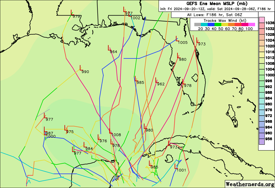
cheezyWXguy wrote:I’ve been watching the last several runs of these models for key details, and here’s what I’ve gathered:

- from run to run, there’s a general consistency with when the gyre takes shape, but there is notable inconsistency in where/when/how the resultant TC forms. Sometimes from an area of vorticity on the periphery of the gyre, sometimes from the gyre itself.
- earlier, stronger development is inversely related to the strength of whatever epac tc forms in the same time period. I’m not sure how legitimate the epac tc is. I am also not sure why the epac tc exerts influence on the Atlantic tc, but seemingly not vice-versa. Maybe someone can answer this

NHC currently gives a 0/50 chance for the Caribbean system, but not the other side of Central America. The only AOI they have in the EPAC is much further west at 110-120W. So yeah, they seem to think the EPAC storm near Central America is just a phantom, even though it's been showing up on GFS multiple times and occasionally also the CMC.

As a side note, after last night's 0z run, this thread was full of people thinking development may not occur at all. Looks like those discussions are now gone after the 12z suite. This is why you don't get hung up on single-run "trends".
4 likes   

Stormlover70
Tropical Storm
Tropical Storm
Posts: 175
Age: 55
Joined: Fri Jun 21, 2024 5:31 am
Location: New port richey

Re: Area of low pressure to develop over the western Caribbean Sea

#614 Postby Stormlover70 » Fri Sep 20, 2024 1:16 pm

DunedinDave wrote:
SFLcane wrote:
gatorcane wrote:Yep, GFS saved loop. A FL peninsula hit not looking likely with that 500MB setup and the CMC has even a stronger ridge. Northern Gulf coast on the other hand... :eek:

https://i.postimg.cc/Nfmk4RTS/gfs-z500a-Norm-watl-fh72-168.gif


"Florida Shield"


Amazing. We dodged another one.
let's hope but I unfortunately don't think it's that cut and dry without a circulation or a set in stone longwave or high.
0 likes   

User avatar
Ivanhater
Storm2k Moderator
Storm2k Moderator
Posts: 11161
Age: 38
Joined: Fri Jul 01, 2005 8:25 am
Location: Pensacola

Re: Area of low pressure to develop over the western Caribbean sea (0/50)

#615 Postby Ivanhater » Fri Sep 20, 2024 1:17 pm

12z Euro Image

Sent from my motorola razr plus 2023 using Tapatalk
4 likes   
Michael

User avatar
MississippiWx
S2K Supporter
S2K Supporter
Posts: 1699
Joined: Sat Aug 14, 2010 1:44 pm
Location: Hattiesburg, Mississippi

Re: Area of low pressure to develop over the western Caribbean sea (0/50)

#616 Postby MississippiWx » Fri Sep 20, 2024 1:17 pm

Ivanhater wrote:12z Euro https://uploads.tapatalk-cdn.com/20240920/95cb1075bb0f76c08c5ec34c807af8eb.jpg

Sent from my motorola razr plus 2023 using Tapatalk


Lol. What a massive storm. 210 hours out...Yeah, I believe it. :P
1 likes   
This post is not an official forecast and should not be used as such. It is just the opinion of MississippiWx and may or may not be backed by sound meteorological data. It is not endorsed by any professional institution including storm2k.org. For Official Information please refer to the NHC and NWS products.

Stormlover70
Tropical Storm
Tropical Storm
Posts: 175
Age: 55
Joined: Fri Jun 21, 2024 5:31 am
Location: New port richey

Re: Area of low pressure to develop over the western Caribbean Sea

#617 Postby Stormlover70 » Fri Sep 20, 2024 1:18 pm

Ivanhater wrote:12z GFS into Mississippi coast

12z Canadian into Central Louisiana

12z Icon Destin.

I think we are starting to see some consolidation onto northern gulf coast
As of right now anything is possible including eating a crow sandwich.
0 likes   

User avatar
StPeteMike
Category 2
Category 2
Posts: 631
Joined: Thu Jun 07, 2018 11:26 pm

Re: Area of low pressure to develop over the western Caribbean sea (0/50)

#618 Postby StPeteMike » Fri Sep 20, 2024 1:25 pm

The nice thing about the convection dying off on the mess off of Honduras is that you can see a small spin around 16.40200° N, 84.27754° W. Probably the first of many vortices to spin up before something can dominate and build up.
0 likes   
The above post is not official and should not be used as such. It is the opinion of the poster and may or may not be backed by sound meteorological data. It is not endorsed by any professional institution or storm2k.org. For official information, please refer to the NHC and NWS products.

TomballEd
Category 2
Category 2
Posts: 700
Age: 61
Joined: Wed Aug 16, 2023 4:52 pm
Location: Spring/Klein area, not Tomball

Re: Area of low pressure to develop over the western Caribbean sea (0/50)

#619 Postby TomballEd » Fri Sep 20, 2024 1:26 pm

It is still too soon to rule anyplace safe, but the majority of the GEFS are New Orleans area to SW Florida. A hint of two favored tracks from the GEFS, towards general New Orleans-Mobile area or SW Florida. 8 or 9 days out, although not much ensemble action, Florida Panhandle and Big Bend are still in the game.

Canadian ensembles have a different split, Florida Panhandle or Louisiana and extending as far W as Houston. I'm still feeling Florida, not sure whether Panhandle/Big Bend or the Peninsula, but anywhere Cameron Parish Louisiana to Marco Island.

They blocked Giphy at work. But loop 144 to 240 on Tropical Tidbits.
1 likes   

Lightning48
Tropical Low
Tropical Low
Posts: 32
Joined: Mon Mar 07, 2022 12:06 pm

Re: Area of low pressure to develop over the western Caribbean sea (0/50)

#620 Postby Lightning48 » Fri Sep 20, 2024 1:26 pm

[quote][/quoteFrank P
]Let's just see how well that FL shield is working come October with a possible back loaded season... :lol:

I agree with you Frank-The complacency in and around the Tampa Bay area is scary!All it takes is one front's timing to be off or an overblown ridge or things of that nature that has been saving us forever to change and go against Tampa and the devastation would catastrophic.
0 likes   


Return to “Talkin' Tropics”

Who is online

Users browsing this forum: No registered users and 52 guests