
Low pressure developing over the western Caribbean Sea (Is Invest 97L)
Moderator: S2k Moderators
Forum rules

The posts in this forum are NOT official forecasts and should not be used as such. They are just the opinion of the poster and may or may not be backed by sound meteorological data. They are NOT endorsed by any professional institution or STORM2K. For official information, please refer to products from the National Hurricane Center and National Weather Service.
-
MHC Tracking
- Tropical Storm

- Posts: 203
- Joined: Mon Mar 15, 2021 10:05 am
Re: Area of low pressure to develop over the western Caribbean Sea
GEFS still quite enthusiastic here. I think models are just handling the CAG badly, the solution of a vertically stretched low across the Gulf from Cancun to NoLa seems more unrealistic than some of yesterday's doom runs.
1 likes
-
MHC Tracking
- Tropical Storm
- Posts: 203
- Joined: Mon Mar 15, 2021 10:05 am
Re: Area of low pressure to develop over the western Caribbean Sea
chaser1 wrote:Stormcenter wrote:GFS is showing a landfall on Sept. 27-28 timeframe.
That’s only a week away. I don’t like it.
Don't like the idea of landfall on the 27/28? Well I don't even "buy it"! For that matter, I'm highly doubting that any EPAC tropical cyclone will develop either. While I'm on my "won't develop rant, Stratton suggests the present Model confusion reminds him of how the models could not see (distinguish) Hurricane Michael from the CAG.
So, kinda like the expression "can't see the forest for the trees", right?
Just NOThere is no tree, and there is NO CAG. And that's the point. Models do what they're supposed to do but the "user" (us) need keep a perspective of what is happening in real time. A disturbance typically requires a couple days to organize, right? Hell, a CAG certainly takes a few days to evolve (if not a week). The reason that models keep pushing back the clock like an "abort mission" is because as we approach any semblance of a model forecast countdown, it realizes that there's no rocket on the launchpad

Look, I have no idea why Nina missed her flight or who neutered the MJO but until some other factor removes the kryptonite from the remainder of this hurricane season then neither Superman nor Batman will save this Riddler of a season.
One must also remember that to blame the models is akin to blaming the mailman. Us humans dont understand how we failed to anticipate the stable & unfavorable conditions throughout the tropics for most of the season. We hypothesize, rationalize, make excuses, and eventually attempt to self correct. Computer model forecasts do the same exact thing but rather than waive their arms and talk like we do, they simply produce graphics instead
I'm pretty sure the current NHC 0/30 (which probably has a ~60% chance of formation over the next week) is a legitimate signal with a real chance of being a hurricane. However, the GFS "signal" to its east looks like the classic convective feedback issue.
0 likes
-
MHC Tracking
- Tropical Storm
- Posts: 203
- Joined: Mon Mar 15, 2021 10:05 am
Re: Area of low pressure to develop over the western Caribbean Sea
00z EPS consistent with development near Yucatan (either in the WCAR or BoC), then a trough pull to the northeast a-la Opal.

0 likes
-
otowntiger
- Category 5

- Posts: 1932
- Joined: Tue Aug 31, 2004 7:06 pm
Re: Area of low pressure to develop over the western Caribbean Sea
I agree. People keep blaming the models- but they are just telling the story of what’s not there, lol.chaser1 wrote:Stormcenter wrote:GFS is showing a landfall on Sept. 27-28 timeframe.
That’s only a week away. I don’t like it.
Don't like the idea of landfall on the 27/28? Well I don't even "buy it"! For that matter, I'm highly doubting that any EPAC tropical cyclone will develop either. While I'm on my "won't develop rant, Stratton suggests the present Model confusion reminds him of how the models could not see (distinguish) Hurricane Michael from the CAG.
So, kinda like the expression "can't see the forest for the trees", right?
Just NO
Look, I have no idea why Nina missed her flight or who neutered the MJO but until some other factor removes the kryptonite from the remainder of this hurricane season then neither Superman nor Batman will save this Riddler of a season.
One must also remember that to blame the models is akin to blaming the mailman. Us humans dont understand how we failed to anticipate the stable & unfavorable conditions throughout the tropics for most of the season. We hypothesize, rationalize, make excuses, and eventually attempt to self correct. Computer model forecasts do the same exact thing but rather than waive their arms and talk like we do, they simply produce graphics instead
2 likes
-
Frank P
- S2K Supporter

- Posts: 2779
- Joined: Fri Aug 29, 2003 10:52 am
- Location: Biloxi Beach, Ms
- Contact:
Re: Area of low pressure to develop over the western Caribbean Sea
latest IR sat loops of the AOI in NW Caribbean

0 likes

Re: Area of low pressure to develop over the western Caribbean Sea
Stormcenter wrote:But tomorrow it could flip back. I don’t trust the
models.ConvergenceZone wrote:mantis83 wrote:Both gfs and cmc with a sloppy mess in the gulf. Hopefully the weaker trends will continue…….
I agree, what a different 24 hours makes. This thread goes from hyper active, to much less so... But I admit, 24 hours ago was scary the way the models were all showing a fairly strong system.
06Z GFS shows the Caribbean low forming in 5 days in the same location as 00Z the current activity near the Honduras coastline is projected to cross CA into the Pacific. The ridging northeast of Florida is still there with the 1014 isobar running from Miami to Pensacola.
Last edited by Nimbus on Fri Sep 20, 2024 5:15 am, edited 1 time in total.
0 likes
-
jlauderdal
- S2K Supporter
- Posts: 7240
- Joined: Wed May 19, 2004 5:46 am
- Location: NE Fort Lauderdale
- Contact:
Re: Area of low pressure to develop over the western Caribbean Sea
Frank P wrote:latest IR sat loops of the AOI in NW Caribbean
https://i.ibb.co/MhS2SRf/goes16-ir-watl.gif
Convection is underway while the models keep slowing it down; expect the windshield wiper to continue and use ensembles until further notice, but even those are iffy at best but bette than OP's; NO to KEY West continues today. Did you see the twitter war yesterday between Paul Dellegatto and Garret Bastardi yesterday, check it out.
1 likes
-
MHC Tracking
- Tropical Storm
- Posts: 203
- Joined: Mon Mar 15, 2021 10:05 am
Re: Area of low pressure to develop over the western Caribbean Sea
Goes without saying we aren't getting a realistic picture of this until the GFS stops forming the phantom EPAC storm...anyone remember when pre-Earl 2022 wouldn't develop on the GFS because it kept forming a "fake" MH in the GoM?

2 likes
Re: Area of low pressure to develop over the western Caribbean Sea
MHC Tracking wrote:Goes without saying we aren't getting a realistic picture of this until the GFS stops forming the phantom EPAC storm...anyone remember when pre-Earl 2022 wouldn't develop on the GFS because it kept forming a "fake" MH in the GoM?
https://cdn.discordapp.com/attachments/1152717498924417024/1286629930011983936/gfs_uv200_watl_20.png?ex=66ee9aff&is=66ed497f&hm=7645b24e29ec7fb65df451318706da61998ad79ca51968d141064ba88fc3969a&
Phantom low or not the 06Z GFS ridging forecast at 180 hours is beginning to stabilize with Florida somewhat protected. With the system stalling mid gulf this run its not going to be pretty..
1 likes
-
MHC Tracking
- Tropical Storm
- Posts: 203
- Joined: Mon Mar 15, 2021 10:05 am
Re: Area of low pressure to develop over the western Caribbean Sea
Nimbus wrote:MHC Tracking wrote:Goes without saying we aren't getting a realistic picture of this until the GFS stops forming the phantom EPAC storm...anyone remember when pre-Earl 2022 wouldn't develop on the GFS because it kept forming a "fake" MH in the GoM?
https://cdn.discordapp.com/attachments/1152717498924417024/1286629930011983936/gfs_uv200_watl_20.png?ex=66ee9aff&is=66ed497f&hm=7645b24e29ec7fb65df451318706da61998ad79ca51968d141064ba88fc3969a&
Phantom low or not the 06Z GFS ridging forecast at 180 hours is beginning to stabilize with Florida somewhat protected. With the system stalling mid gulf this run its not going to be pretty..
The setup is reminiscent of Opal, as it was on the 00z EPS. I doubt the "quick exit" some models have been advertising unless the storm gets strung out like Barry '07/Colin '16/Alex2022
0 likes
Re: Area of low pressure to develop over the western Caribbean Sea
MHC Tracking wrote:Nimbus wrote:MHC Tracking wrote:Goes without saying we aren't getting a realistic picture of this until the GFS stops forming the phantom EPAC storm...anyone remember when pre-Earl 2022 wouldn't develop on the GFS because it kept forming a "fake" MH in the GoM?
https://cdn.discordapp.com/attachments/1152717498924417024/1286629930011983936/gfs_uv200_watl_20.png?ex=66ee9aff&is=66ed497f&hm=7645b24e29ec7fb65df451318706da61998ad79ca51968d141064ba88fc3969a&
Phantom low or not the 06Z GFS ridging forecast at 180 hours is beginning to stabilize with Florida somewhat protected. With the system stalling mid gulf this run its not going to be pretty..
The setup is reminiscent of Opal, as it was on the 00z EPS. I doubt the "quick exit" some models have been advertising unless the storm gets strung out like Barry '07/Colin '16/Alex2022
Getting trapped off Grand Isle for two days as it deepens into the 960's isn't much fun either.
0 likes
-
Ivanhater

- Storm2k Moderator

- Posts: 11222
- Age: 39
- Joined: Fri Jul 01, 2005 8:25 am
- Location: Pensacola
Re: Area of low pressure to develop over the western Caribbean Sea
Last couple of GFS runs don't look good for north central gulf coast
0 likes
Michael
-
MHC Tracking
- Tropical Storm
- Posts: 203
- Joined: Mon Mar 15, 2021 10:05 am
Re: Area of low pressure to develop over the western Caribbean Sea
Nimbus wrote:MHC Tracking wrote:Nimbus wrote:
Phantom low or not the 06Z GFS ridging forecast at 180 hours is beginning to stabilize with Florida somewhat protected. With the system stalling mid gulf this run its not going to be pretty..
The setup is reminiscent of Opal, as it was on the 00z EPS. I doubt the "quick exit" some models have been advertising unless the storm gets strung out like Barry '07/Colin '16/Alex2022
Getting trapped off Grand Isle for two days as it deepens into the 960's isn't much fun either.
Large high-end C2 in that location would be a surge machine...looks like landfall eventually inbetween Gulfport and Mobile

0 likes

Re: Area of low pressure to develop over the western Caribbean Sea
6z GFS slows down vs 0z and much stronger once again

Sent from my iPad using Tapatalk
Sent from my iPad using Tapatalk
1 likes
Re: Area of low pressure to develop over the western Caribbean Sea

Sent from my iPad using Tapatalk
0 likes
-
Ivanhater
- Storm2k Moderator
- Posts: 11222
- Age: 39
- Joined: Fri Jul 01, 2005 8:25 am
- Location: Pensacola
Re: Area of low pressure to develop over the western Caribbean Sea
06Z Gfs
Sent from my motorola razr plus 2023 using Tapatalk
Sent from my motorola razr plus 2023 using Tapatalk
0 likes
Michael

Re: Area of low pressure to develop over the western Caribbean Sea
jlauderdal wrote:Frank P wrote:latest IR sat loops of the AOI in NW Caribbean
https://i.ibb.co/MhS2SRf/goes16-ir-watl.gif
Convection is underway while the models keep slowing it down; expect the windshield wiper to continue and use ensembles until further notice, but even those are iffy at best but bette than OP's; NO to KEY West continues today. Did you see the twitter war yesterday between Paul Dellegatto and Garret Bastardi yesterday, check it out.
Can you post a link? Thanks
0 likes
-
Blown Away

- S2K Supporter
- Posts: 10253
- Joined: Wed May 26, 2004 6:17 am
Re: Area of low pressure to develop over the western Caribbean Sea
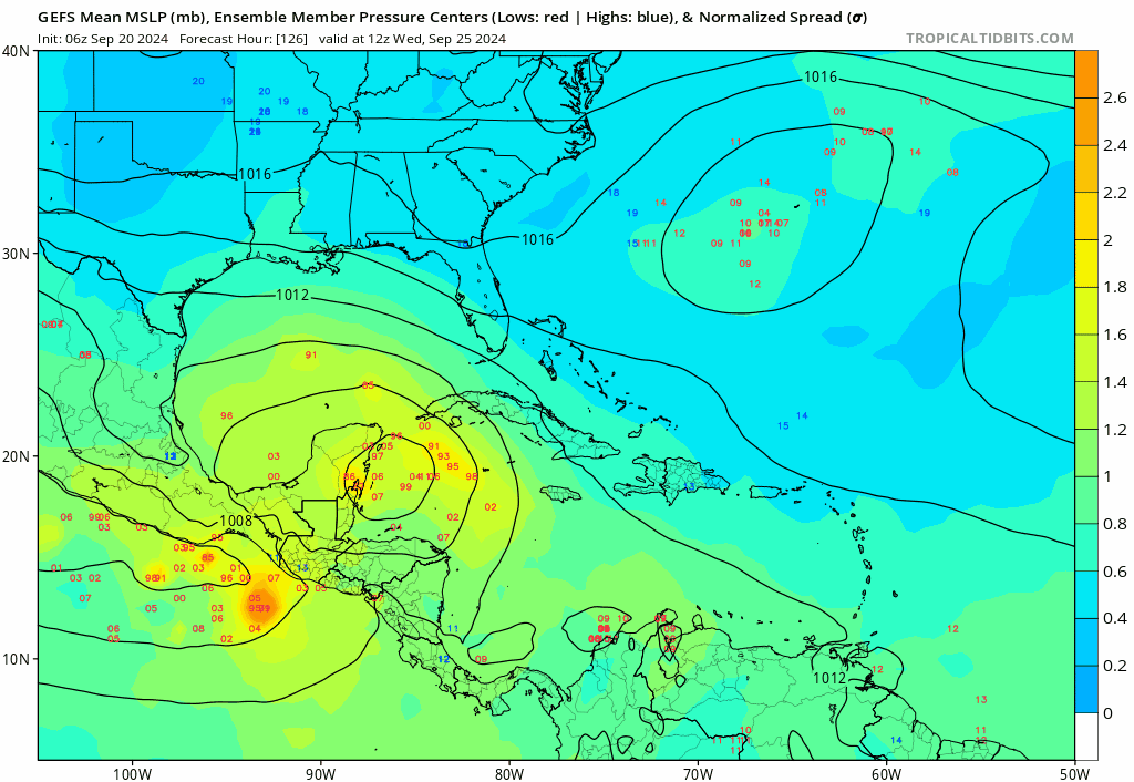
IMO, 06z GEFS are still in a big disagreement on timing. The FL W coast and Big Bend area members have this AOI landfalling in 7-8 days while NGOM have landfall in 9-10 day range. The faster developing AOI goes in @FL W coast and slower moving system goes to NGOM coast... The operational GFS keeps bouncing around on these timing scenarios, you can see the big timing difference between 18z vs 06z this morning... JMHO
2 likes
Hurricane Eye Experience: David 79, Irene 99, Frances 04, Jeanne 04, Wilma 05… Hurricane Brush Experience: Andrew 92, Erin 95, Floyd 99, Matthew 16, Irma 17, Ian 22, Nicole 22…
-
toad strangler

- S2K Supporter
- Posts: 4546
- Joined: Sun Jul 28, 2013 3:09 pm
- Location: Earth
- Contact:
Re: Area of low pressure to develop over the western Caribbean Sea
Blown Away wrote:[url]https://i.postimg.cc/vH8B0rSt/gfs-ememb-lowlocs-watl-fh126-240.gif [/url]
IMO, 06z GEFS are still in a big disagreement on timing. The FL W coast and Big Bend area members have this AOI landfalling in 7-8 days while NGOM have landfall in 9-10 day range. The faster developing AOI goes in @FL W coast and slower moving system goes to NGOM coast... The operational GFS keeps bouncing around on these timing scenarios, you can see the big timing difference between 18z vs 06z this morning... JMHO
I hate to beat a dead horse, but that's because there is nothing there yet to really look at as far as a seedling disturbance. Models will naturally struggle with that, no?
4 likes
My Weather Station
https://www.wunderground.com/dashboard/pws/KFLPORTS603
https://www.wunderground.com/dashboard/pws/KFLPORTS603
Who is online
Users browsing this forum: dexterlabio and 111 guests