
Low pressure developing over the western Caribbean Sea (Is Invest 97L)
Moderator: S2k Moderators
Forum rules

The posts in this forum are NOT official forecasts and should not be used as such. They are just the opinion of the poster and may or may not be backed by sound meteorological data. They are NOT endorsed by any professional institution or STORM2K. For official information, please refer to products from the National Hurricane Center and National Weather Service.
Re: Area of low pressure to develop over the western Caribbean Sea
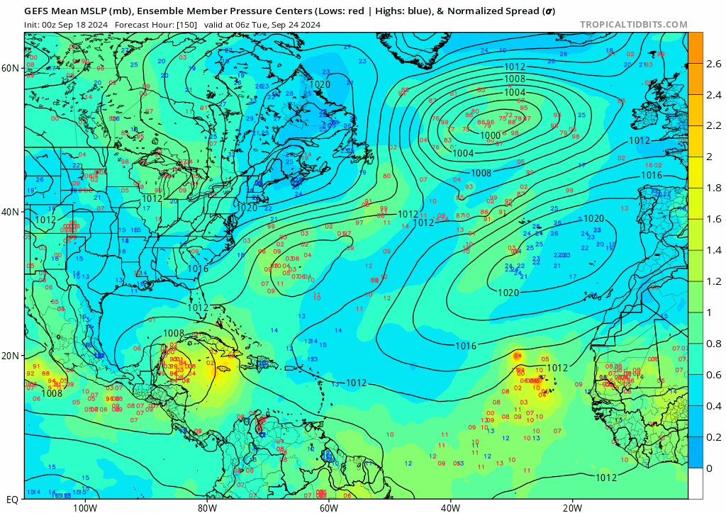
For people saying genesis is being pushed back, here's GEFS trend:
0 likes
TC naming lists: retirements and intensity
Most aggressive Advisory #1's in North Atlantic (cr. kevin for starting the list)
Most aggressive Advisory #1's in North Atlantic (cr. kevin for starting the list)
-
Category5Kaiju

- Category 5

- Posts: 4347
- Joined: Thu Dec 24, 2020 12:45 pm
- Location: Seattle during the summer, Phoenix during the winter
Re: Area of low pressure to develop over the western Caribbean Sea
otowntiger wrote:Emmett_Brown wrote:Overall, less model agreement today. Feels like we are going backward; solutions are all over the place. Hopefully tomorrow clears things up a bit.
I think the trend for less agreement, less run to run consistency, more spread, and pushed back timing means there is less and less chance that this thing will ever develop into anything of consequence. It seems there is a good chance it ends up over in the WPAC.
You mean the EPAC, right?
Also, I'm going to have to disagree with this general idea, at least as of now, simply due to the fact that this is a Central American Gyre genesis that the models are trying to catch on. This explains why there's so much discrepancy in between models and in between one model's runs. Tracking a tropical wave that turns into a storm is one thing, but tracking storms born from CAGs is much more complicated and messy. At least with the recent GEFS ensembles, I also don't really see a noticeable trend for development further down the line either (Teban shows this earlier).
3 likes
Unless explicitly stated, all information in my posts is based on my own opinions and observations. Tropical storms and hurricanes can be extremely dangerous. Refer to an accredited weather research agency or meteorologist if you need to make serious decisions regarding an approaching storm.
-
Stratton23
- Category 5
- Posts: 3578
- Joined: Fri Jul 21, 2023 10:59 pm
- Location: Katy, Tx
Re: Area of low pressure to develop over the western Caribbean Sea
otowntiger yeah thats not going to happen, thats not in the cards, its not going to cross over into the EPAC
1 likes
-
StPeteMike

- Category 2

- Posts: 657
- Joined: Thu Jun 07, 2018 11:26 pm
Re: Area of low pressure to develop over the western Caribbean Sea
I stuck with my 2018 Michael analysis today and boy, did we not have a real good consensus back then. About the same time back then, the models were showing either a system moving up to the GOM or crossing Cuba and going through the Bahamas then….. going west to southwest and hitting Daytona area. Once we got to where we should be Sunday, future Michael was also struggling with multiple vortices rotating around the gyre over CA.
I still think the models are struggling with the gyre and how to forecast how this storm escapes the grip of it. But a lot of the models in previous storms have shown a bias of developing two storms when one really only forms. Same happened with future Michael.
I still think the models are struggling with the gyre and how to forecast how this storm escapes the grip of it. But a lot of the models in previous storms have shown a bias of developing two storms when one really only forms. Same happened with future Michael.
5 likes
The above post is not official and should not be used as such. It is the opinion of the poster and may or may not be backed by sound meteorological data. It is not endorsed by any professional institution or storm2k.org. For official information, please refer to the NHC and NWS products.

Re: Area of low pressure to develop over the western Caribbean Sea
ronjon wrote:SFLcane wrote:Guessing game till we have an actual disturbance. HP that had been protecting FL has been gone last two runs. We shall see
Perhaps a precursor to a faster solution. Seems intuitive that a faster solution may be in store this time of year as we head toward the end of Sept. But as I mentioned yesterday, we're gonna get vastly different solutions until we get better consensus on the 500 mb pattern next week.
Literally the key to the whole thing. I said yesterday I wasn’t going to even look at it until the weekend because we are almost a week away from genesis. But I couldn’t help peeking and commenting on the 12z runs today. It’s all about see what they say and watch what happens in the upper pattern.
0 likes
-
toad strangler

- S2K Supporter

- Posts: 4546
- Joined: Sun Jul 28, 2013 3:09 pm
- Location: Earth
- Contact:
Re: Area of low pressure to develop over the western Caribbean Sea
Stratton23 wrote:As of right now, the GFS is a clear outlier in terms of an eastern gulf solution , we shall see what the overnight runs bring
None of this matters Until there’s an actual disturbance. I would take absolutely nothing from any of these runs.
2 likes
My Weather Station
https://www.wunderground.com/dashboard/pws/KFLPORTS603
https://www.wunderground.com/dashboard/pws/KFLPORTS603
Re: Area of low pressure to develop over the western Caribbean Sea
otowntiger wrote:Emmett_Brown wrote:Overall, less model agreement today. Feels like we are going backward; solutions are all over the place. Hopefully tomorrow clears things up a bit.
I think the trend for less agreement, less run to run consistency, more spread, and pushed back timing means there is less and less chance that this thing will ever develop into anything of consequence. It seems there is a good chance it ends up over in the WPAC.
When all the models show lower pressure in an area this far out, it’s pretty likely that’s going to happen.
1 likes
Re: Area of low pressure to develop over the western Caribbean Sea
toad strangler wrote:Stratton23 wrote:As of right now, the GFS is a clear outlier in terms of an eastern gulf solution , we shall see what the overnight runs bring
None of this matters Until there’s an actual disturbance. I would take absolutely nothing from any of these runs.
I also disagree Toad. I’m not talking about landfall or intensity. We are 9-10 days out. But there are still clues.
0 likes
-
SFLcane

- S2K Supporter
- Posts: 10281
- Age: 48
- Joined: Sat Jun 05, 2010 1:44 pm
- Location: Lake Worth Florida
Re: Area of low pressure to develop over the western Caribbean Sea
toad strangler wrote:Stratton23 wrote:As of right now, the GFS is a clear outlier in terms of an eastern gulf solution , we shall see what the overnight runs bring
None of this matters Until there’s an actual disturbance. I would take absolutely nothing from any of these runs.
Every model is to be taken with caution at this lead time without even a patch of clouds down there lol. What’s important to watch is for clues on what might be the steering mechanism that’s going to steer this thing. Right now what I have noticed in the last 2 gfs runs is the hp has been nonexistent over FL and a faster motion which could allow whatever is down there to be captured by the trof quicker. Lots of moving parts but let’s get a disturbance before we start saying this model is an outlier.
1 likes
Re: Area of low pressure to develop over the western Caribbean Sea
As we wait for our watched pot to boil I think it's worth noting that the weather doesn't care what our deep desires are, know that we are watching or even aware we exist. To that end, it's been my experience that intense agenda posting, be it bull, bear or geographic in nature is predictable but rarely contributory. The weather is going to do what it wants and we're just along for the ride. Leaning heavily into climo makes sense and even in slower years one would expect development in this region. The probability that nothing happens is likely very low considering incoming forcing, record OHC and climo. It is safe to take some time off here but something is probably on the way for someone...details to be determined.
8 likes
-
otowntiger
- Category 5
- Posts: 1932
- Joined: Tue Aug 31, 2004 7:06 pm
Re: Area of low pressure to develop over the western Caribbean Sea
otowntiger wrote:Emmett_Brown wrote:Overall, less model agreement today. Feels like we are going backward; solutions are all over the place. Hopefully tomorrow clears things up a bit.
I think the trend for less agreement, less run to run consistency, more spread, and pushed back timing means there is less and less chance that this thing will ever develop into anything of consequence. It seems there is a good chance it ends up over in the EPAC.
0 likes
Re: Area of low pressure to develop over the western Caribbean Sea
SFLcane wrote:toad strangler wrote:Stratton23 wrote:As of right now, the GFS is a clear outlier in terms of an eastern gulf solution , we shall see what the overnight runs bring
None of this matters Until there’s an actual disturbance. I would take absolutely nothing from any of these runs.
Every model is to be taken with caution at this lead time without even a patch of clouds down there lol. What’s important to watch is for clues on what might be the steering mechanism that’s going to steer this thing. Right now what I have noticed in the last 2 gfs runs is the hp has been nonexistent over FL and a faster motion which could allow whatever is down there to be captured by the trof quicker. Lots of moving parts but let’s get a disturbance before we start saying this model is an outlier.
You are right. But I didn’t look at the 18z GFS upper because for 12z the GFS was a way outlier. It pulled in a back door cut off low in the NE which dragged it over and up. It was ludicrous. Don’t take that as I don’t think it can hit Florida. I hope it doesn’t because I’m supposed to be moving a ton of stuff back home to Pensacola next weekend and some stuff from home back to New Orleans on Sunday 29th which means I have a 179 mile, as the crow flies, stretch of Gulf I need clear plus 150 miles of fringe east and west. 12z EC missed the trough. So did Icon. Canadian as well which is kind of telling because it can also have an eastern bias. But it built a high pressure wall with the circulation around the high kicking it from N to NNW.
Ref. https://www.tropicaltidbits.com/analysi ... 1912&fh=12
I don't think that’s onto anything but it’s something to note 10 days out for future reference. Hopefully one of you who has an access to the UKMET will describe its 500mb patterns next week so that gets in the mix too.
Last edited by Steve on Thu Sep 19, 2024 8:30 pm, edited 2 times in total.
1 likes
-
Spacecoast

- Category 2
- Posts: 773
- Joined: Thu Aug 31, 2017 2:03 pm
Re: Area of low pressure to develop over the western Caribbean Sea
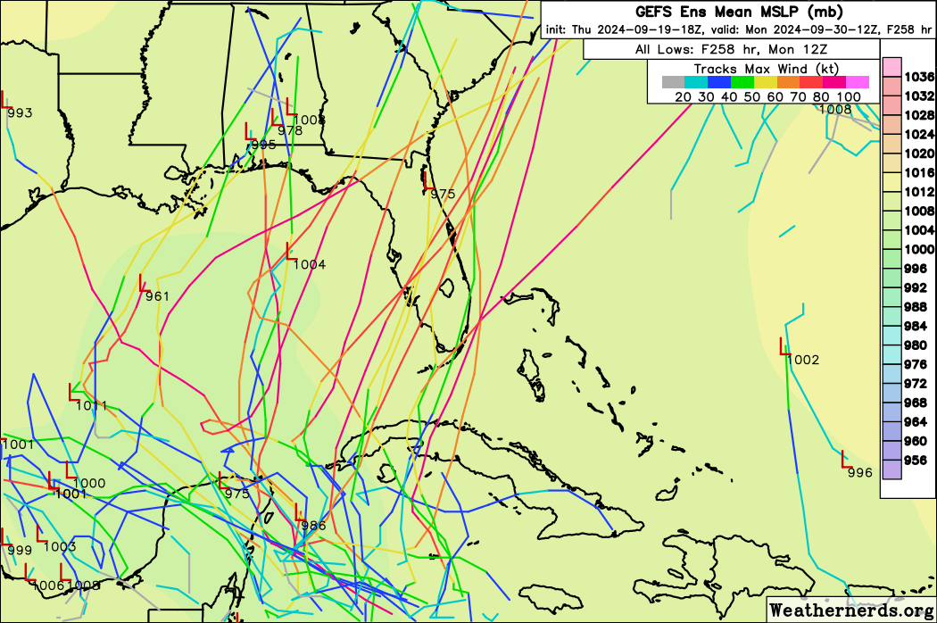
Last model of the night.....
18z EC-AIFS: The last 3 EC-AIFS runs have been nearly identical, and similar, (but a little east of) CMC.

18z EC-AIFS: The last 3 EC-AIFS runs have been nearly identical, and similar, (but a little east of) CMC.
0 likes
-
TallyTracker
- Category 2
- Posts: 787
- Joined: Thu Oct 11, 2018 2:46 pm
Re: Area of low pressure to develop over the western Caribbean Sea
Looking at the big picture, there are some things we can glean from the models. As many have noted, it’s too early to nail down track, intensity, etc. Larger scale items we can get some likely clues.
1. A disturbance is likely to form in the next 4-5 days.
2. Said disturbance is likely to move into the southern Gulf.
3. Odds of tropical development is likely high within 7 days.
4. At some point, the cyclone is likely to move NE. This is both the favored movement climatologically and shown by most ensemble members. There could be initial westward movement; however, a movement to the NE like Opal, Michael, and Idalia seems likely eventually. Where the NE movement begins and the trough strength will have a large influence on any potential landfall location.
5. Moving northward into the Gulf, any cyclone is likely to have a significant impact somewhere even if it’s just heavy rain. Most of the Gulf Coast is soggy after Francine and the front during the past week.
3 likes
Fran '96, Georges '98, Gordon '00, Gabrielle '01, Charley '04, Frances '04, Jeanne '04, Barry '07, Fay '08, Debby '12, Matthew '16, Emily '17, Irma '17, Michael ‘18, Elsa ‘21, Fred ‘21, Mindy ‘21, Nicole ‘22, Idalia ‘23, Debby ‘24, Helene ‘24
-
TampaWxLurker
- Tropical Storm

- Posts: 196
- Joined: Thu Aug 01, 2024 8:20 am
Re: Area of low pressure to develop over the western Caribbean Sea
Models tend to have a terrible time early on with these gyre-originating storms. And they'll continue to have fits until the dominant area of low pressure consolidates. And it usually seems like it takes FOREVER for a single dominant low to develop out of these gyres.
And its worse because of the intense attention being paid. A boiling pot and all that.
We're probably not going to have anything definite for another 3+ days or so. Which makes it worse because by the time it does develop, there'll only be another 2-4 days before landfall, wherever that is.
I really dislike these Central American Gyre storms, is what I'm saying.
5 likes
-
sphelps8681
- Category 2
- Posts: 785
- Joined: Thu Aug 16, 2007 5:37 pm
- Location: Somewhere over the rainbow
Re: Area of low pressure to develop over the western Caribbean Sea
Well with all this hype with models I guess the W Gulf Coast is all in the clear. Can we talk about the dynamics of what could make this move one way or another since no center is formed yet. Instead of posting a model well this model shows this location. Kinda makes people on here less aware of if and when or not coming to them. So novice in all this.
0 likes
-
Stratton23
- Category 5
- Posts: 3578
- Joined: Fri Jul 21, 2023 10:59 pm
- Location: Katy, Tx
Re: Area of low pressure to develop over the western Caribbean Sea
sphelps8681 the western gulf coast states are definitely not in the clear, i wouldn’t even rule out as far west as the middle- upper texas coast, climatology does favor a NE turn eventually though, but their have been many storms over the years to impact the western part of the gulf even in late september, ifs a very tricky and complex steering setup
Last edited by Stratton23 on Thu Sep 19, 2024 8:44 pm, edited 1 time in total.
2 likes
-
StPeteMike
- Category 2
- Posts: 657
- Joined: Thu Jun 07, 2018 11:26 pm
Re: Area of low pressure to develop over the western Caribbean Sea
TampaWxLurker wrote:Models tend to have a terrible time early on with these gyre-originating storms. And they'll continue to have fits until the dominant area of low pressure consolidates. And it usually seems like it takes FOREVER for a single dominant low to develop out of these gyres.
And its worse because of the intense attention being paid. A boiling pot and all that.
We're probably not going to have anything definite for another 3+ days or so. Which makes it worse because by the time it does develop, there'll only be another 2-4 days before landfall, wherever that is.
I really dislike these Central American Gyre storms, is what I'm saying.
Between the Central American Gyre and the close proximity from the North Caribbean to Florida with a potential trough to pick it up… always hate these setups. Especially for our area!
We should have something by Monday to get a good understanding on this storm.
1 likes
The above post is not official and should not be used as such. It is the opinion of the poster and may or may not be backed by sound meteorological data. It is not endorsed by any professional institution or storm2k.org. For official information, please refer to the NHC and NWS products.
Who is online
Users browsing this forum: Google Adsense [Bot] and 109 guests