Low pressure developing over the western Caribbean Sea (Is Invest 97L)

This is the general tropical discussion area. Anyone can take their shot at predicting a storms path.

Moderator: S2k Moderators

Forum rules

The posts in this forum are NOT official forecasts and should not be used as such. They are just the opinion of the poster and may or may not be backed by sound meteorological data. They are NOT endorsed by any professional institution or STORM2K. For official information, please refer to products from the National Hurricane Center and National Weather Service.

Help Support Storm2K
Message
Author
MHC Tracking
Tropical Storm
Tropical Storm
Posts: 195
Joined: Mon Mar 15, 2021 10:05 am

Re: Area of low pressure to develop over the western Caribbean Sea

#281 Postby MHC Tracking » Thu Sep 19, 2024 6:54 am

Frank P wrote:GFS 06z loop in the GOM. landfall shifted east towards PC and surge on Mexico City would be catastrophic if it were to verify, but this will change too down the road, they always do this far out.
https://i.ibb.co/3mTM3pM/floop-gfs-2024091906-sfcwind-mslp-gom.gif

That's 1919 hurricane/Carla level size. TS winds from the Yucatan to NOLA simultaneously.
2 likes   

LAF92
Tropical Depression
Tropical Depression
Posts: 51
Joined: Fri Aug 18, 2023 6:27 pm

Re: Area of low pressure to develop over the western Caribbean Sea

#282 Postby LAF92 » Thu Sep 19, 2024 7:16 am

Image
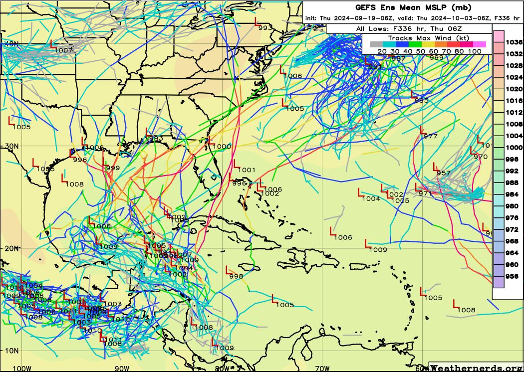
06 GEFS ensembles through 228 hours big spread
1 likes   

Pas_Bon
Tropical Depression
Tropical Depression
Posts: 73
Age: 45
Joined: Mon Jul 15, 2019 12:25 pm
Location: League City, TX

Re: Area of low pressure to develop over the western Caribbean Sea

#283 Postby Pas_Bon » Thu Sep 19, 2024 7:20 am

LAF92 wrote:[url]https://i.postimg.cc/7ZqbR1Wv/IMG-1483.png [/url]
06 GEFS ensembles through 228 hours big spread


Everyone from Nicaragua to Newfoundland should be ensuring final plans are in place by the end of this weekend.
7 likes   

Frank P
S2K Supporter
S2K Supporter
Posts: 2776
Joined: Fri Aug 29, 2003 10:52 am
Location: Biloxi Beach, Ms
Contact:

Re: Area of low pressure to develop over the western Caribbean Sea

#284 Postby Frank P » Thu Sep 19, 2024 7:21 am

the 00z Euro is just as bad...
Image
2 likes   

TomballEd
Category 2
Category 2
Posts: 692
Age: 61
Joined: Wed Aug 16, 2023 4:52 pm
Location: Spring/Klein area, not Tomball

Re: Area of low pressure to develop over the western Caribbean Sea

#285 Postby TomballEd » Thu Sep 19, 2024 7:38 am

I can't Giphy at work, but look at GEFS shear 180 to 240 hours. Ensembles show vert, very, very, favorable shear, under 10 knots, with an anticyclone aloft. Very hostile shear continues across the Northern Gulf the entire period. System could get very strong in W Gulf, before hitting shear as it approaches land. On the hostile shear front, see Francine and more notably Ian, as the storm approaches shear, ventilation/upward motion is maximized, so whatever storm forms wouldn't weaken dramatically as long as it doesn't stall under the shear for any length of time.

I found one unblocked program so I present to you OHC. ~100 kJ/cm^2 and very light shear would be co-located. If the storm is a slow mover in the S. Gulf, some of the model solutions with sub-930 mb pressures could be realistic.
Image
4 likes   

TomballEd
Category 2
Category 2
Posts: 692
Age: 61
Joined: Wed Aug 16, 2023 4:52 pm
Location: Spring/Klein area, not Tomball

Re: Area of low pressure to develop over the western Caribbean Sea

#286 Postby TomballEd » Thu Sep 19, 2024 7:40 am


A spread in the ensembles when the system won't form for another 3 or 4 days is to be expected. I wouldn't trust any one ensemble suite or op model that says Cat 4 in Tampa Bay or Cat 3 into NOLA before the hurricane models have a defined circulation.

The ensemble spread in the GEFS and the EPS are saying a wide option of strength and landfalls are possible.
0 likes   

DunedinDave
Tropical Storm
Tropical Storm
Posts: 227
Joined: Fri Aug 25, 2023 10:31 am

Re: Area of low pressure to develop over the western Caribbean Sea

#287 Postby DunedinDave » Thu Sep 19, 2024 7:50 am

Very reminiscent of Opal looking at the GFS.
0 likes   

3090
Category 2
Category 2
Posts: 549
Age: 65
Joined: Fri Aug 19, 2011 4:01 pm

Re: Area of low pressure to develop over the western Caribbean Sea

#288 Postby 3090 » Thu Sep 19, 2024 7:55 am

:D Simply said. Waaaaayyy to early in this event for any remote guess 1) iF ANYTHING WILL FORM….2) THE INTENSITY….3) THE TRACK.

Message boards are interesting but certainly can be stressful. All good though.

Stay calm and just keep alert. All there is to do at this time.

And of course; post your thoughts on this message board…
3 likes   

User avatar
SFLcane
S2K Supporter
S2K Supporter
Posts: 10163
Age: 47
Joined: Sat Jun 05, 2010 1:44 pm
Location: Lake Worth Florida

Re: Area of low pressure to develop over the western Caribbean Sea

#289 Postby SFLcane » Thu Sep 19, 2024 8:03 am

5 likes   

User avatar
Nimbus
Category 5
Category 5
Posts: 5300
Joined: Mon Jul 19, 2004 10:54 am

Re: Area of low pressure to develop over the western Caribbean Sea

#290 Postby Nimbus » Thu Sep 19, 2024 8:17 am

MHC Tracking wrote:
Frank P wrote:GFS 06z loop in the GOM. landfall shifted east towards PC and surge on Mexico City would be catastrophic if it were to verify, but this will change too down the road, they always do this far out.
https://i.ibb.co/3mTM3pM/floop-gfs-2024091906-sfcwind-mslp-gom.gif

That's 1919 hurricane/Carla level size. TS winds from the Yucatan to NOLA simultaneously.


GFS is confident enough to forecast a Jackie Gleason "away we go" in the BOC?
Probably a tomb stone run..
0 likes   

User avatar
Emmett_Brown
Category 5
Category 5
Posts: 1432
Joined: Wed Aug 24, 2005 9:10 pm
Location: Sarasota FL

Re: Area of low pressure to develop over the western Caribbean Sea

#291 Postby Emmett_Brown » Thu Sep 19, 2024 8:41 am

So far today, it seems like the models want to delay development a bit, and therefore there is a larger spread in the ensemble tracks. The trend is for more uncertainty, which is very 2024
0 likes   

User avatar
Blown Away
S2K Supporter
S2K Supporter
Posts: 10145
Joined: Wed May 26, 2004 6:17 am

Re: Area of low pressure to develop over the western Caribbean Sea

#292 Postby Blown Away » Thu Sep 19, 2024 8:56 am

Image
06 GEFS... The GFS tracking WNW from NW Caribbean into W GOM and then sharp ENE turn in GOM along with dragging this out for the next 10 days, just doesn't seem fluid to me...

JMHO, likely outcomes, stays weak and trends W into Mexico or this area ramps up quick and then moves into EGOM or even over Cuba and E of SFL to me is just as likely...
1 likes   
Hurricane Eye Experience: David 79, Irene 99, Frances 04, Jeanne 04, Wilma 05... EYE COMING MY WAY IN 2024…
Hurricane Brush Experience: Andrew 92, Erin 95, Floyd 99, Matthew 16, Irma 17, Ian 22, Nicole 22…

User avatar
kevin
Category 5
Category 5
Posts: 2586
Age: 26
Joined: Wed Aug 28, 2019 4:35 am

Re: Area of low pressure to develop over the western Caribbean Sea

#293 Postby kevin » Thu Sep 19, 2024 8:59 am

06z EC-AIFS. Much more east than the 00z (which basically had it over Mexico and never made it more than a TS). Landfall +222hrs west of New Orleans, 975 mb.

Image
1 likes   

LAF92
Tropical Depression
Tropical Depression
Posts: 51
Joined: Fri Aug 18, 2023 6:27 pm

Re: Area of low pressure to develop over the western Caribbean Sea

#294 Postby LAF92 » Thu Sep 19, 2024 9:05 am

kevin wrote:06z EC-AIFS. Much more east than the 00z (which basically had it over Mexico and never made it more than a TS). Landfall +222hrs west of New Orleans, 975 mb.

https://i.imgur.com/EpOeNhB.png

The 00z EC AI made landfall in Mexico then event made its way to the west coast of Florida. It was a crazy run
1 likes   

jlauderdal
S2K Supporter
S2K Supporter
Posts: 7182
Joined: Wed May 19, 2004 5:46 am
Location: NE Fort Lauderdale
Contact:

Re: Area of low pressure to develop over the western Caribbean Sea

#295 Postby jlauderdal » Thu Sep 19, 2024 9:11 am

kevin wrote:06z EC-AIFS. Much more east than the 00z (which basically had it over Mexico and never made it more than a TS). Landfall +222hrs west of New Orleans, 975 mb.

https://i.imgur.com/EpOeNhB.png

Back to reality, all interests from New Orleans to Key West and Points NE,same as yesterday. Have to watch fro development, the gyre can move to a snails pace while troughs go by
1 likes   

User avatar
Emmett_Brown
Category 5
Category 5
Posts: 1432
Joined: Wed Aug 24, 2005 9:10 pm
Location: Sarasota FL

Re: Area of low pressure to develop over the western Caribbean Sea

#296 Postby Emmett_Brown » Thu Sep 19, 2024 9:27 am

It is just me, or does the modeling seem to depict a much larger than normal wind field for our possible distant future TC. It's almost like the gyre doesn't spawn the storm, the whole gyre becomes the storm
4 likes   

User avatar
ThomasW
Tropical Depression
Tropical Depression
Posts: 78
Age: 44
Joined: Thu May 19, 2022 10:59 am
Contact:

Re: Area of low pressure to develop over the western Caribbean Sea

#297 Postby ThomasW » Thu Sep 19, 2024 9:42 am

Emmett_Brown wrote:It is just me, or does the modeling seem to depict a much larger than normal wind field for our possible distant future TC. It's almost like the gyre doesn't spawn the storm, the whole gyre becomes the storm

Not sure whether it's legitimate or not. Models initially showed what would become Idalia being quite large, but when the disturbance got together, it was fairly small.
0 likes   

TallyTracker
Category 2
Category 2
Posts: 734
Joined: Thu Oct 11, 2018 2:46 pm

Re: Area of low pressure to develop over the western Caribbean Sea

#298 Postby TallyTracker » Thu Sep 19, 2024 9:56 am

kevin wrote:06z EC-AIFS. Much more east than the 00z (which basically had it over Mexico and never made it more than a TS). Landfall +222hrs west of New Orleans, 975 mb.

https://i.imgur.com/EpOeNhB.png


That’s basically a Francine redux for the Louisiana area both in terms of track and intensity. I think the surge would be far worse though due to the size of the windfield and time to pile the water up on the coast.

The best GFS analong is Opal it seems. Before Michael, Opal was the big storm talked about in the Panama City area. That would be a major blow.
1 likes   
Fran '96, Georges '98, Gordon '00, Gabrielle '01, Charley '04, Frances '04, Jeanne '04, Barry '07, Fay '08, Debby '12, Matthew '16, Emily '17, Irma '17, Michael ‘18, Elsa ‘21, Fred ‘21, Mindy ‘21, Nicole ‘22, Idalia ‘23, Debby ‘24, Helene ‘24

User avatar
StPeteMike
Category 2
Category 2
Posts: 631
Joined: Thu Jun 07, 2018 11:26 pm

Re: Area of low pressure to develop over the western Caribbean Sea

#299 Postby StPeteMike » Thu Sep 19, 2024 10:25 am

Think 12z will be back to the eventual track for the future storm. I’m still not buying the NW/W direction over the Yucatán just yet.

Agree with jlauderdal anywhere between NO to South Florida should keep an eye out.
0 likes   
The above post is not official and should not be used as such. It is the opinion of the poster and may or may not be backed by sound meteorological data. It is not endorsed by any professional institution or storm2k.org. For official information, please refer to the NHC and NWS products.

Pipelines182
Tropical Storm
Tropical Storm
Posts: 159
Joined: Tue Jul 02, 2024 8:46 am

Re: Area of low pressure to develop over the western Caribbean Sea

#300 Postby Pipelines182 » Thu Sep 19, 2024 10:35 am

3090 wrote::D Simply said. Waaaaayyy to early in this event for any remote guess 1) iF ANYTHING WILL FORM….2) THE INTENSITY….3) THE TRACK.

Message boards are interesting but certainly can be stressful. All good though.

Stay calm and just keep alert. All there is to do at this time.

And of course; post your thoughts on this message board…


Gotta disagree here. When the NHC issues a 40% chance of development that means that it is not too early to make some early predictions. Cyclogenesis is forecasted to occur within that 5-7 day window, which is when models tend to become more accurate. At this stage we can start discussing at some level of accuracy general development regions, initial motion, and synoptic scale features. It's certainly too early to start predicting landfall locations, timing, or intensity beyond those 7 days.
3 likes   


Return to “Talkin' Tropics”

Who is online

Users browsing this forum: Ulf and 25 guests