Low pressure developing over the western Caribbean Sea (Is Invest 97L)
Moderator: S2k Moderators
Forum rules

The posts in this forum are NOT official forecasts and should not be used as such. They are just the opinion of the poster and may or may not be backed by sound meteorological data. They are NOT endorsed by any professional institution or STORM2K. For official information, please refer to products from the National Hurricane Center and National Weather Service.

Re: Area of low pressure to develop over the western Caribbean Sea
Certainly could have a western GOM solution but given the time of year (3rd week of Sept) just based on climatology would cause you to think central or eastern GOM. The models are showing landfall in 9 to 10 days and we all know how reliable upper air forecasts are for that time frame (hint: not very). I've seen a lot posts about we don't have a center formed yet so we don't know where it will go but I think more crucially we won't know 500 mb synoptics well until at least 4 to 5 days out.
5 likes
-
Drewsey
- Tropical Low

- Posts: 20
- Joined: Fri Jun 05, 2020 7:53 pm
- Location: Raceland, LA (Lafourche Parish)
Re: Area of low pressure to develop over the western Caribbean Sea
cajungal wrote:Why is it always Louisiana getting wiped off the map? Geez
Yeah keeping my boards in my garage another week just in case we gotta board up again. I don’t wish it on anyone but jeez I’m tired. Places are still being fixed from Ida. Luckily Francine wasn’t nearly as bad. Little water in the house, mainly from the wind pushing it under our back door, and out of power for a few days.
1 likes
-
StPeteMike

- Category 2

- Posts: 657
- Joined: Thu Jun 07, 2018 11:26 pm
Re: Area of low pressure to develop over the western Caribbean Sea
ronjon wrote:Certainly could have a western GOM solution but given the time of year (3rd week of Sept) just based on climatology would cause you to think central or eastern GOM. The models are showing landfall in 9 to 10 days and we all know how reliable upper air forecasts are for that time frame (hint: not very). I've seen a lot posts about we don't have a center formed yet so we don't know where it will go but I think more crucially we won't know 500 mb synoptics well until at least 4 to 5 days out.
Agreed and my point with Michael a few pages back. 4 days out, models said shear was going to keep him around Cat 1 strength. Sunday and Monday will give us a way better understanding.
4 likes
The above post is not official and should not be used as such. It is the opinion of the poster and may or may not be backed by sound meteorological data. It is not endorsed by any professional institution or storm2k.org. For official information, please refer to the NHC and NWS products.
-
SFLcane

- S2K Supporter

- Posts: 10281
- Age: 48
- Joined: Sat Jun 05, 2010 1:44 pm
- Location: Lake Worth Florida
Re: Area of low pressure to develop over the western Caribbean Sea
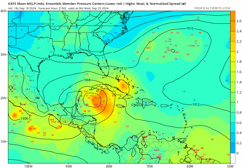
Majority of the GEFS ensembles remain east of the operational over Florida.
2 likes

Re: Area of low pressure to develop over the western Caribbean Sea
ronjon wrote:Certainly could have a western GOM solution but given the time of year (3rd week of Sept) just based on climatology would cause you to think central or eastern GOM. The models are showing landfall in 9 to 10 days and we all know how reliable upper air forecasts are for that time frame (hint: not very). I've seen a lot posts about we don't have a center formed yet so we don't know where it will go but I think more crucially we won't know 500 mb synoptics well until at least 4 to 5 days out.
Hurricane Lili, Hurricane Rita, Hurricane Ike, Hurricane Delta were all after September 15th. It’s very possible for a western solution
4 likes
-
wzrgirl1

- S2K Supporter
- Posts: 1360
- Joined: Sat Sep 04, 2004 6:44 am
- Location: Pembroke Pines, Florida
Re: Area of low pressure to develop over the western Caribbean Sea
Steve wrote:Not to completely be that punk, but if anyone has been on desktop on this site for the last 15 or so years, my location has been “Not a Statecaster”. When I joined back in 2002 or so they used to have what they called wobble wars. Texas Jex found every reason to post why storm x was coming their way. Same thing for Louisiana Lou, Mississippi Motha and Sarasota Slim. Yes there are precedents for many situations. And yes there is climatology. And science as well. But it kind of gets annoying if someone is in a location and repeatedly uses that as an argument or justification for where a system or potential system might be headed. Whether I was in Florida, Alabama or Louisiana at the time, I always went the other way and made sure that my current location had zero bearing on the models or scenarios that maybe brought something closer to me. Everyone here is a storm geek else we wouldn’t be here. And we all know the anxiety and excitement that comes with having to face danger to ourselves, our loved ones and our properties. I guess I’m just asking for people to look at a bigger picture (which on this page they have).
The ensembles clearly aren’t any better in this situation from GFS 12z to GFS 18z. They are completely different outcomes. Even if a quality local NWS office like Slidell, Lake Charles or Miami picks up on a current model’s scenario so they can address it with those in their outlook area, we should all be able to filter that by situation. If it’s 2-3 days out from a landfall of a developed system, we should be able to recognize that and weight it for what it is just like we should be able to be skeptical of a not yet formed system in a general area we believe there might be one 10 days out and say that we think it’s coming our way because of whatever.
This particular scenario doesn’t have that many precedents for September 18th. Even Texas is in the game of a big high follows a trough that doesn’t pick this up.
A voice of reason.
6 likes
Re: Area of low pressure to develop over the western Caribbean Sea
Louisiana is still a hot zone st this time of year. It's getting late for TX...but anyone east of Sabine pass is fair game with climo tilting east with time. Heading into peak risk in the Eastern Gulf with these systems from the south. Something is probably going to happen but what and where is a total crapshoot other than weighting climo.
3 likes
-
Nederlander
- S2K Supporter
- Posts: 1259
- Joined: Sat Jul 19, 2008 4:28 pm
- Location: Conroe, TX
Re: Area of low pressure to develop over the western Caribbean Sea
LAF92 wrote:ronjon wrote:Certainly could have a western GOM solution but given the time of year (3rd week of Sept) just based on climatology would cause you to think central or eastern GOM. The models are showing landfall in 9 to 10 days and we all know how reliable upper air forecasts are for that time frame (hint: not very). I've seen a lot posts about we don't have a center formed yet so we don't know where it will go but I think more crucially we won't know 500 mb synoptics well until at least 4 to 5 days out.
Hurricane Lili, Hurricane Rita, Hurricane Ike, Hurricane Delta were all after September 15th. It’s very possible for a western solution
Never say never, but I would lean central or eastern gulf this late into the season. You are correct on all but Ike, which was Sep 13th, (I know it’s 2 days) but your point is valid. This has been a weird season, but the western gulf “should” start closing the gate soon.
1 likes
-
cajungal

- Category 5

- Posts: 2354
- Age: 49
- Joined: Sun Mar 14, 2004 9:34 pm
- Location: Schriever, Louisiana (60 miles southwest of New Orleans)
Re: Area of low pressure to develop over the western Caribbean Sea
Drewsey wrote:cajungal wrote:Why is it always Louisiana getting wiped off the map? Geez
Yeah keeping my boards in my garage another week just in case we gotta board up again. I don’t wish it on anyone but jeez I’m tired. Places are still being fixed from Ida. Luckily Francine wasn’t nearly as bad. Little water in the house, mainly from the wind pushing it under our back door, and out of power for a few days.
Thibodaux here. See you are in Raceland. We had 2 rooms in our house that got floodwater from Francine. Husband will have to take walls out. And we have a trip planned in New Orleans 25-29th for a reunion so worried possible storm could interfere
1 likes
-
hurricane2025
- Category 1

- Posts: 254
- Joined: Thu Apr 08, 2021 10:36 am
Re: Area of low pressure to develop over the western Caribbean Sea
Been a very weird year if trough doesn’t come then it will happen but can’t never say never till we have a strong front
1 likes
-
Blown Away

- S2K Supporter
- Posts: 10253
- Joined: Wed May 26, 2004 6:17 am
Re: Area of low pressure to develop over the western Caribbean Sea
18z GEFS
2 likes
Hurricane Eye Experience: David 79, Irene 99, Frances 04, Jeanne 04, Wilma 05… Hurricane Brush Experience: Andrew 92, Erin 95, Floyd 99, Matthew 16, Irma 17, Ian 22, Nicole 22…
-
WaveBreaking

- Category 2
- Posts: 727
- Joined: Sun Jun 30, 2024 11:33 am
- Location: US
Re: Area of low pressure to develop over the western Caribbean Sea
Doesn’t surprise me that the Happy Hour ensembles have at least two Hurricane Phoenix tracks
1 likes
I am NOT a professional meteorologist, so take all of my posts with a grain of salt. My opinions are mine and mine alone.

Re: Area of low pressure to develop over the western Caribbean Sea
LAF92 wrote:ronjon wrote:Certainly could have a western GOM solution but given the time of year (3rd week of Sept) just based on climatology would cause you to think central or eastern GOM. The models are showing landfall in 9 to 10 days and we all know how reliable upper air forecasts are for that time frame (hint: not very). I've seen a lot posts about we don't have a center formed yet so we don't know where it will go but I think more crucially we won't know 500 mb synoptics well until at least 4 to 5 days out.
Hurricane Lili, Hurricane Rita, Hurricane Ike, Hurricane Delta were all after September 15th. It’s very possible for a western solution
Please no...!
0 likes
Not a professional forecast by any means.
Audrey'57, Hilda'64, Betsy '65, Edith'71, Carmen'74, Danny'85, Juan'85, Andrew'92, Iniki'92 (while on vacation in Kauai), Lili'02, Rita'05, Humberto'07, Gustav'08, Ike'08, Isaac'12, Monsoonal Depression'16, Harvey'17, Barry'19, Laura'20, Delta'20, Ida'21.
Audrey'57, Hilda'64, Betsy '65, Edith'71, Carmen'74, Danny'85, Juan'85, Andrew'92, Iniki'92 (while on vacation in Kauai), Lili'02, Rita'05, Humberto'07, Gustav'08, Ike'08, Isaac'12, Monsoonal Depression'16, Harvey'17, Barry'19, Laura'20, Delta'20, Ida'21.
-
Category5Kaiju

- Category 5
- Posts: 4345
- Joined: Thu Dec 24, 2020 12:45 pm
- Location: Seattle during the summer, Phoenix during the winter
Re: Area of low pressure to develop over the western Caribbean Sea
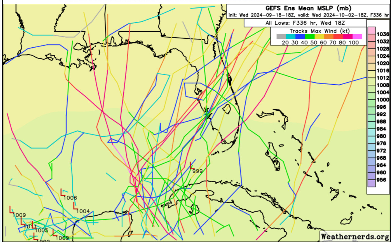
That’s quite the track cluster in the Yucatán Channel.
0 likes
Unless explicitly stated, all information in my posts is based on my own opinions and observations. Tropical storms and hurricanes can be extremely dangerous. Refer to an accredited weather research agency or meteorologist if you need to make serious decisions regarding an approaching storm.
-
gatorcane

- S2K Supporter
- Posts: 23708
- Age: 48
- Joined: Sun Mar 13, 2005 3:54 pm
- Location: Boca Raton, FL
Re: Area of low pressure to develop over the western Caribbean Sea
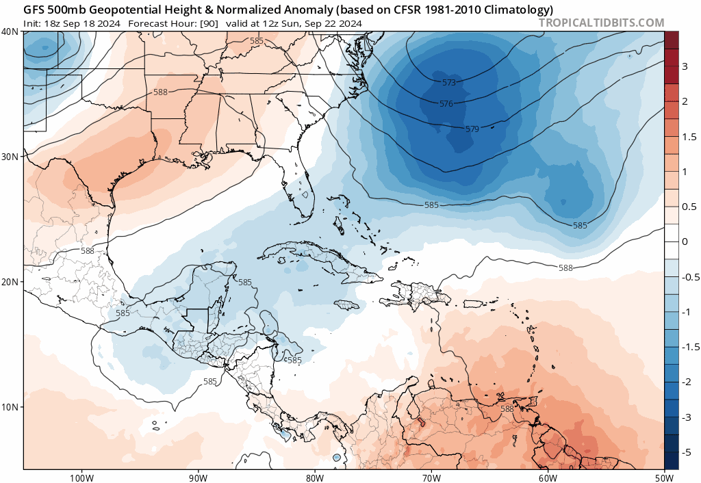
The ECMWF, GFS, and CMC models seems to be coming into agreement on a ridge building in over the SE US and Florida starting in 90 hours through 168+ hours. For example, GFS below. That would take this system on a general north or NW track into the southern or SE Gulf like the NHC mentions. If this low develops, my thought is it heads more towards the northern Gulf coast somewhere and not the FL peninsula. We'll see lots of different solutions from the models (track and intensity-wise) until something consolidates, should know more this weekend.
4 likes

Re: Area of low pressure to develop over the western Caribbean Sea
gatorcane wrote:The ECMWF, GFS, and CMC models seems to be coming into agreement on a ridge building in over the SE US and Florida starting in 90 hours through 168+ hours. For example, GFS below. That would take this system on a general north or NW track into the southern or SE Gulf like the NHC mentions. If this low develops, my thought is it heads more towards the northern Gulf coast somewhere and not the FL peninsula. We'll see lots of different solutions from the models (track and intensity-wise) until something consolidates, should know more this weekend.
https://i.postimg.cc/YSCvPT5v/gfs-z500a-Norm-watl-fh90-192.gif
It will be important to compare model depictions at 500mb with what happens over the next 5-7 days so we can see which models are seeing things the best and who has what solutions. Ima start looking harder at that this weekend.
I think a larger than normal spread for late September (when it would theoretically landfall) exists this far out as there are inland Central America scenarios, Yucatán, Bay of Campeche, NW Gulf all the way around to sw FL. It’s 2024 Gulf of Mexico, so I am tentatively leaning toward the Icon and the ECMWF with some weight to everything else.
3 likes
Re: Area of low pressure to develop over the western Caribbean Sea
Steve wrote:gatorcane wrote:The ECMWF, GFS, and CMC models seems to be coming into agreement on a ridge building in over the SE US and Florida starting in 90 hours through 168+ hours. For example, GFS below. That would take this system on a general north or NW track into the southern or SE Gulf like the NHC mentions. If this low develops, my thought is it heads more towards the northern Gulf coast somewhere and not the FL peninsula. We'll see lots of different solutions from the models (track and intensity-wise) until something consolidates, should know more this weekend.
https://i.postimg.cc/YSCvPT5v/gfs-z500a-Norm-watl-fh90-192.gif
It will be important to compare model depictions at 500mb with what happens over the next 5-7 days so we can see which models are seeing things the best and who has what solutions. Ima start looking harder at that this weekend.
I think a larger than normal spread for late September (when it would theoretically landfall) exists this far out as there are inland Central America scenarios, Yucatán, Bay of Campeche, NW Gulf all the way around to sw FL. It’s 2024 Gulf of Mexico, so I am tentatively leaning toward the Icon and the ECMWF with some weight to everything else.
Well if this system is going to become a major this weekend (Sunday) will be a bit late for officials to make a cohesive decision to evacuate a given area. As I remember for Ida the many pros and the NHC were quick to pull the trigger on getting people in SELA out of harms way before Ida was a CAT1.
1 likes
-
Spacecoast

- Category 2
- Posts: 773
- Joined: Thu Aug 31, 2017 2:03 pm
Re: Area of low pressure to develop over the western Caribbean Sea
18z EX-AIFS: Slightly West of 12z run. Similar to CMC track

1 likes
-
Hypercane_Kyle

- Category 5
- Posts: 3465
- Joined: Sat Mar 07, 2015 7:58 pm
- Location: Cape Canaveral, FL
Re: Area of low pressure to develop over the western Caribbean Sea
Definitely a classic, dangerous setup coming out of the western Caribbean on the models. We're in full windshield wiper mode with the models.
2 likes
My posts are my own personal opinion, defer to the National Hurricane Center (NHC) and other NOAA products for decision making during hurricane season.
-
StPeteMike
- Category 2
- Posts: 657
- Joined: Thu Jun 07, 2018 11:26 pm
Re: Area of low pressure to develop over the western Caribbean Sea
3090 wrote:Steve wrote:gatorcane wrote:The ECMWF, GFS, and CMC models seems to be coming into agreement on a ridge building in over the SE US and Florida starting in 90 hours through 168+ hours. For example, GFS below. That would take this system on a general north or NW track into the southern or SE Gulf like the NHC mentions. If this low develops, my thought is it heads more towards the northern Gulf coast somewhere and not the FL peninsula. We'll see lots of different solutions from the models (track and intensity-wise) until something consolidates, should know more this weekend.
https://i.postimg.cc/YSCvPT5v/gfs-z500a-Norm-watl-fh90-192.gif
It will be important to compare model depictions at 500mb with what happens over the next 5-7 days so we can see which models are seeing things the best and who has what solutions. Ima start looking harder at that this weekend.
I think a larger than normal spread for late September (when it would theoretically landfall) exists this far out as there are inland Central America scenarios, Yucatán, Bay of Campeche, NW Gulf all the way around to sw FL. It’s 2024 Gulf of Mexico, so I am tentatively leaning toward the Icon and the ECMWF with some weight to everything else.
Well if this system is going to become a major this weekend (Sunday) will be a bit late for officials to make a cohesive decision to evacuate a given area. As I remember for Ida the many pros and the NHC were quick to pull the trigger on getting people in SELA out of harms way before Ida was a CAT1.
This will not be a major by this weekend. TD status likely won’t occur until Monday midday in the Bay of Honduras/North Caribbean. Potential landfall is Thursday/Friday depending on the track it takes.
Side note, the temperature forecast for my area still show the trough coming through Florida around Thursday/Friday. Take it as is, considering the 18z seem to have a ridge building over Florida.
1 likes
The above post is not official and should not be used as such. It is the opinion of the poster and may or may not be backed by sound meteorological data. It is not endorsed by any professional institution or storm2k.org. For official information, please refer to the NHC and NWS products.
Who is online
Users browsing this forum: Ulf and 373 guests