
ATL: FRANCINE - Remnants - Discussion
Moderator: S2k Moderators
-
tolakram
- Admin

- Posts: 20186
- Age: 62
- Joined: Sun Aug 27, 2006 8:23 pm
- Location: Florence, KY (name is Mark)
Re: ATL: FRANCINE - Hurricane - Discussion
saved loop
1 likes
M a r k
- - - - -
Join us in chat: Storm2K Chatroom Invite. Android and IOS apps also available.
The posts in this forum are NOT official forecasts and should not be used as such. Posts are NOT endorsed by any professional institution or STORM2K.org. For official information and forecasts, please refer to NHC and NWS products.

Re: ATL: FRANCINE - Hurricane - Discussion
99kt flight level winds, would support an upgrade to cat 2.
4 likes
Kendall -> SLO -> PBC
Memorable Storms: Katrina (for its Florida landfall...) Wilma Matthew Irma
Memorable Storms: Katrina (for its Florida landfall...) Wilma Matthew Irma
-
tolakram
- Admin
- Posts: 20186
- Age: 62
- Joined: Sun Aug 27, 2006 8:23 pm
- Location: Florence, KY (name is Mark)
Re: ATL: FRANCINE - Hurricane - Discussion
Looks to be decoupling as it makes landfall. Going to be a lot of damage, power failures, flooding and a long cleanup regardless.
saved loop

saved loop
3 likes
M a r k
- - - - -
Join us in chat: Storm2K Chatroom Invite. Android and IOS apps also available.
The posts in this forum are NOT official forecasts and should not be used as such. Posts are NOT endorsed by any professional institution or STORM2K.org. For official information and forecasts, please refer to NHC and NWS products.
- - - - -
Join us in chat: Storm2K Chatroom Invite. Android and IOS apps also available.
The posts in this forum are NOT official forecasts and should not be used as such. Posts are NOT endorsed by any professional institution or STORM2K.org. For official information and forecasts, please refer to NHC and NWS products.
-
Pipelines182
- Tropical Storm

- Posts: 159
- Joined: Tue Jul 02, 2024 8:46 am
Re: ATL: FRANCINE - Hurricane - Discussion
dhweather wrote:Stormcenter wrote:I love the it’s only a cat.1 comments. Ladies and gentlemen it’s a hurricane, enough said.
We're really lucky it wasn't a major - if it had gotten its act together a day earlier, its probably a major right now.
Nice, I had this on my hurricane bingo card lol
5 likes
-
cajungal

- Category 5

- Posts: 2354
- Age: 49
- Joined: Sun Mar 14, 2004 9:34 pm
- Location: Schriever, Louisiana (60 miles southwest of New Orleans)
Re: ATL: FRANCINE - Hurricane - Discussion
Big gust here in Thibodaux almost knocked me over on my front porch. My shirt flew all the way up. Thank goodness none of my neighbors were out
11 likes


Re: ATL: FRANCINE - Hurricane - Discussion
99 knots flight level winds and pressure back down, so where is that destructive shear some where talking about? lol.
201500 2840N 09106W 6968 03027 9878 +118 +085 232094 095 075 002 00
201530 2841N 09107W 6971 03016 9872 +117 +092 231095 096 071 001 00
201600 2842N 09108W 6965 03020 9860 +122 +090 231095 096 073 001 00
201630 2843N 09109W 6974 03005 9852 +125 +090 231098 099 073 001 00
201700 2844N 09111W 6961 03015 9844 +131 +078 229095 098 073 002 00
201730 2845N 09112W 6968 03003 9839 +130 +087 225095 099 073 001 00
201800 2847N 09113W 6964 03002 9824 +136 +102 225092 097 071 003 00
201830 2848N 09115W 6975 02986 9801 +151 +098 227089 092 067 000 00
201900 2849N 09116W 6975 02978 9790 +155 +098 227087 088 063 000 00
201930 2850N 09117W 6966 02982 9780 +159 +078 227086 087 059 001 00
202000 2851N 09118W 6973 02971 9776 +158 +098 224076 084 057 002 00
202030 2852N 09120W 6965 02976 9770 +158 +111 221066 071 050 001 00
202100 2854N 09121W 6976 02960 9761 +163 +111 224057 064 044 000 00
202130 2855N 09123W 6969 02964 9754 +164 +107 223052 053 043 002 00
202200 2855N 09123W 6969 02964 9745 +170 +093 227046 051 040 000 00
202230 2857N 09126W 6968 02957 9742 +170 +089 230037 041 034 000 02
202300 2858N 09127W 6970 02947 9726 +179 +085 228037 038 029 000 32
6 likes

Re: ATL: FRANCINE - Hurricane - Discussion
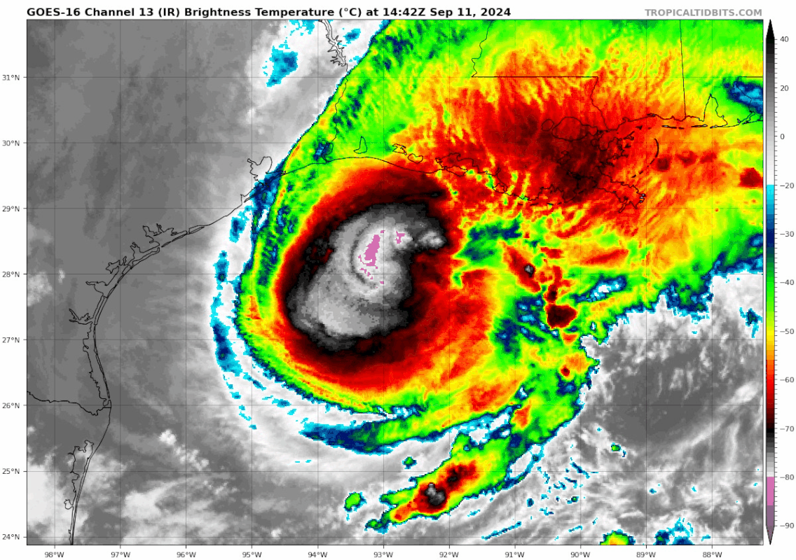
It’s still strong but you can kind of see the impacts on IR. Also looks like New Orleans will get clipped by at least the edge of the COC
https://www.tropicaltidbits.com/sat/sat ... product=ir
Radar
https://radar.weather.gov/station/KHDC/standard
https://www.tropicaltidbits.com/sat/sat ... product=ir
Radar
https://radar.weather.gov/station/KHDC/standard
2 likes
-
ColdMiser123

- Professional-Met

- Posts: 905
- Age: 29
- Joined: Mon Sep 26, 2016 3:26 pm
- Location: Northeast US
Re: ATL: FRANCINE - Hurricane - Discussion
Drop supports 972 mb.
99 kt flight level wind supports 90 kt at the surface. However, peak SFMR on this pass was only around 75 kt. So a blend would get you 80-85 kt.
99 kt flight level wind supports 90 kt at the surface. However, peak SFMR on this pass was only around 75 kt. So a blend would get you 80-85 kt.
0 likes
B.S., M.S., Meteorology & Atmospheric Science
-
Hurricane2022

- Category 5
- Posts: 2086
- Joined: Tue Aug 23, 2022 11:38 pm
- Location: Araçatuba, Brazil
Re: ATL: FRANCINE - Hurricane - Discussion
Now 85 kt/972 mbar. Officially a Category 2 hurricane just before landfall.
8 likes
Sorry for the bad English sometimes...!
For reliable and detailed information for any meteorological phenomenon, please consult the National Hurricane Center, Joint Typhoon Warning Center , or your local Meteo Center.
--------
ECCE OMNIA NOVA FACIAM (Ap 21,5).
For reliable and detailed information for any meteorological phenomenon, please consult the National Hurricane Center, Joint Typhoon Warning Center , or your local Meteo Center.
--------
ECCE OMNIA NOVA FACIAM (Ap 21,5).
-
ColdMiser123
- Professional-Met
- Posts: 905
- Age: 29
- Joined: Mon Sep 26, 2016 3:26 pm
- Location: Northeast US
Re: ATL: FRANCINE - Hurricane - Discussion
Will make landfall within the next couple of hours, at near peak intensity.
Why it's prudent to always prepare for a category above forecast.
Why it's prudent to always prepare for a category above forecast.
7 likes
B.S., M.S., Meteorology & Atmospheric Science

Re: ATL: FRANCINE - Hurricane - Discussion
great, because of this upgrade I just a crap ton more work to do. 35 branches in path at CAT 2 triggers damage surveys. Horrible looking CAT 2 at that....thanks Francine.. 
2 likes
-
WaveBreaking

- Category 2

- Posts: 727
- Joined: Sun Jun 30, 2024 11:33 am
- Location: US
Re: ATL: FRANCINE - Hurricane - Discussion
Hurricane2022 wrote:Now 85 kt/972 mbar. Officially a Category 2 hurricane just before landfall.
Crazy that it was able to pull off a last-minute strengthening even though it looked like it was keeling over on satellite
5 likes
I am NOT a professional meteorologist, so take all of my posts with a grain of salt. My opinions are mine and mine alone.

Re: ATL: FRANCINE - Hurricane - Discussion
Steve wrote:It’s still strong but you can kind of see the impacts on IR. Also looks like New Orleans will get clipped by at least the edge of the COC
https://www.tropicaltidbits.com/sat/sat ... product=ir
Radar
https://radar.weather.gov/station/KHDC/standard
Kind of a tight fit on the Grand Isle side and the larger eyewall will bring some water NW up the bay.
But cat one winds bring a lot less surge.
Sorry about the power though that is going to be a mess.
1 likes
-
InfernoFlameCat

- Category 5
- Posts: 2127
- Age: 22
- Joined: Mon Dec 14, 2020 10:52 am
- Location: Buford, GA
Re: ATL: FRANCINE - Hurricane - Discussion
otowntiger wrote:Teban54 wrote:GCANE wrote:Ha, IR just went to pot

https://i.postimg.cc/bJ86NHNq/goes16-ir-06-L-202409111442.gif
Looks like she’s past her peak. At this rate of deterioration (dare I say it? Lol!) may not be a hurricane at landfall. I know I’m tempting fate by saying this but that is certainly a rapid decline in appearance and rise in BP, 7 mb climb in just a couple hours.
Well this aged like milk. cat 2 knocking on Louisiana’s door! Although I thought it was weakening too.
4 likes
I am by no means a professional. DO NOT look at my forecasts for official information or make decisions based on what I post.
Goal: to become a registered expert over tropical and subtropical cyclones.
Goal: to become a registered expert over tropical and subtropical cyclones.
-
ColdMiser123
- Professional-Met
- Posts: 905
- Age: 29
- Joined: Mon Sep 26, 2016 3:26 pm
- Location: Northeast US
Re: ATL: FRANCINE - Hurricane - Discussion
WaveBreaking wrote:Hurricane2022 wrote:Now 85 kt/972 mbar. Officially a Category 2 hurricane just before landfall.
Crazy that it was able to pull off a last-minute strengthening even though it looked like it was keeling over on satellite
Saw something similar with Isaias, where satellite wasn't the most impressive, but jet dynamics were nonetheless allowing for intensification to take place under the hood.
2 likes
B.S., M.S., Meteorology & Atmospheric Science
Re: ATL: FRANCINE - Hurricane - Discussion
Nimbus wrote:Steve wrote:It’s still strong but you can kind of see the impacts on IR. Also looks like New Orleans will get clipped by at least the edge of the COC
https://www.tropicaltidbits.com/sat/sat ... product=ir
Radar
https://radar.weather.gov/station/KHDC/standard
Kind of a tight fit on the Grand Isle side and the larger eyewall will bring some water NW up the bay.
But cat one winds bring a lot less surge.
Sorry about the power though that is going to be a mess.
It’s all good. Ngl I’m hoping to see some transformers popping later. Weird to me is I feel like the shear (per IR above) may be helping push/focus the energy on the NE side. Could also be land interaction but there really isn’t much land right along the coast except in small spots.
Edit to say here comes some -80. Last couple days it was a slight burst in the afternoon but better in the evening. Maybe some surprises inland later for some people?
0 likes
Re: ATL: FRANCINE - Hurricane - Discussion
Steve wrote:Nimbus wrote:Steve wrote:It’s still strong but you can kind of see the impacts on IR. Also looks like New Orleans will get clipped by at least the edge of the COC
https://www.tropicaltidbits.com/sat/sat ... product=ir
Radar
https://radar.weather.gov/station/KHDC/standard
Kind of a tight fit on the Grand Isle side and the larger eyewall will bring some water NW up the bay.
But cat one winds bring a lot less surge.
Sorry about the power though that is going to be a mess.
It’s all good. Ngl I’m hoping to see some transformers popping later. Weird to me is I feel like the shear (per IR above) may be helping push/focus the energy on the NE side. Could also be land interaction but there really isn’t much land right along the coast except in small spots.
Edit to say here comes some -80. Last couple days it was a slight burst in the afternoon but better in the evening. Maybe some surprises inland later for some people?
This site updated 7 minutes ago not very far "inland" and probably representative of what New Orleans will get.
Just 45 knot gusts and pretty close to the eyewall.
https://aviationweather.gov/data/metar/ ... de_taf=yes
1 likes
Re: ATL: FRANCINE - Hurricane - Discussion
That’s fine with me. I love some TS conditions blowing through. You get the day off and can enjoy it a little if you are into it, as all of us are, without too much danger.
1 likes
-
wxman57

- Moderator-Pro Met

- Posts: 23175
- Age: 68
- Joined: Sat Jun 21, 2003 8:06 pm
- Location: Houston, TX (southwest)
Re: ATL: FRANCINE - Hurricane - Discussion
Hard to tell it's true intensity trend, since recon wasn't there for quite a while and it was too far offshore for radar to look below 10,000 ft. All the rigs it passed indicated max wind 75 kts. There might have been a few spots of higher, but I think 75 kts was representative of the overall wind. Now that it is near shore, radar and recon indicate 100 kts aloft, but SFMR still indicates 75 kts. Not much of an intensification trend. Eastern eyewall is weaker than western eyewall. Better for New Orleans. I don't think New Orleans will get hit as badly as Houston did. We had sustained 45-55 mph wind with gusts of 100 for quite a while with Beryl. Yeah, just a TS passing through knocked out power for 2.3 million, including me. It doesn't take sustained hurricane force wind to cause a lot of power outages.
1 likes
-
Hypercane_Kyle

- Category 5
- Posts: 3465
- Joined: Sat Mar 07, 2015 7:58 pm
- Location: Cape Canaveral, FL
Re: ATL: FRANCINE - Hurricane - Discussion
Both track and intensity were well predicted, NHC called for Cat 2 just yesterday.
3 likes
My posts are my own personal opinion, defer to the National Hurricane Center (NHC) and other NOAA products for decision making during hurricane season.
Who is online
Users browsing this forum: No registered users and 38 guests