ATL: FRANCINE - Remnants - Discussion
Moderator: S2k Moderators
-
Bamagirl2408

- Tropical Depression

- Posts: 80
- Joined: Wed Aug 24, 2016 11:19 pm
- Location: Mobile AL
Re: ATL: FRANCINE - Hurricane - Discussion
Always a lurker, never a poster. TWC has probably said 10 times in last hour that the official track is W of New Orleans but keep mentioning over and over it could go right over Greater New Orleans and keep showing their high res model. Just thought it was of interest. Should we expect possibly one small final track change to include them?
2 likes
-
weeniepatrol

- Category 5

- Posts: 1345
- Joined: Sat Aug 22, 2020 5:30 pm
- Location: WA State

-
Hurricane2022

- Category 5
- Posts: 2092
- Joined: Tue Aug 23, 2022 11:38 pm
- Location: Araçatuba, Brazil
Re: ATL: FRANCINE - Hurricane - Discussion
Extrap 974.6
Looks like FranCine is finally RI'ing
Looks like FranCine is finally RI'ing
0 likes
Sorry for the bad English sometimes...!
For reliable and detailed information for any meteorological phenomenon, please consult the National Hurricane Center, Joint Typhoon Warning Center , or your local Meteo Center.
--------
ECCE OMNIA NOVA FACIAM (Ap 21,5).
For reliable and detailed information for any meteorological phenomenon, please consult the National Hurricane Center, Joint Typhoon Warning Center , or your local Meteo Center.
--------
ECCE OMNIA NOVA FACIAM (Ap 21,5).
-
CrazyC83
- Professional-Met

- Posts: 34316
- Joined: Tue Mar 07, 2006 11:57 pm
- Location: Deep South, for the first time!
Re: ATL: FRANCINE - Hurricane - Discussion
Bamagirl2408 wrote:Always a lurker, never a poster. TWC has probably said 10 times in last hour that the official track is W of New Orleans but keep mentioning over and over it could go right over Greater New Orleans and keep showing their high res model. Just thought it was of interest. Should we expect possibly one small final track change to include them?
Changes to the track are still possible and a track directly over NOLA is not impossible.
0 likes
-
REDHurricane

- Category 1

- Posts: 438
- Age: 28
- Joined: Sun Jul 03, 2022 2:36 pm
- Location: Northeast Pacific Ocean
Re: ATL: FRANCINE - Hurricane - Discussion
Here's a good look at Francine as she works to mix out the mid-level dry air to the west and continue intensifying:
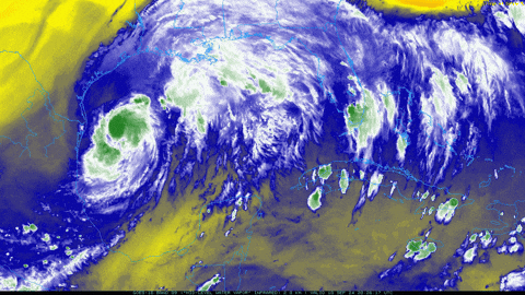
3 likes


Re: ATL: FRANCINE - Hurricane - Discussion
Bedtime. I’m hoping tomorrow afternoon is more fun than destructive. Francine has maybe 6 hours left to bottom out in pressure. Perhaps mid-low 970s before maybe coming back up a couple millibars?
2 likes
-
Hurricane2022
- Category 5
- Posts: 2092
- Joined: Tue Aug 23, 2022 11:38 pm
- Location: Araçatuba, Brazil
Re: ATL: FRANCINE - Hurricane - Discussion
Steve wrote:Bedtime. I’m hoping tomorrow afternoon is more fun than destructive. Francine has maybe 6 hours left to bottom out in pressure. Perhaps mid-low 970s before maybe coming back up a couple millibars?
In fact Francine is likely already at mid-low 970s. Expect this to peak at ~960 mbar today afternoon before shear starts to affect it.
5 likes
Sorry for the bad English sometimes...!
For reliable and detailed information for any meteorological phenomenon, please consult the National Hurricane Center, Joint Typhoon Warning Center , or your local Meteo Center.
--------
ECCE OMNIA NOVA FACIAM (Ap 21,5).
For reliable and detailed information for any meteorological phenomenon, please consult the National Hurricane Center, Joint Typhoon Warning Center , or your local Meteo Center.
--------
ECCE OMNIA NOVA FACIAM (Ap 21,5).
-
Craters
- Category 1
- Posts: 428
- Joined: Sat Aug 24, 2013 2:34 pm
- Location: Alvin, TX (south of Houston)
Re: ATL: FRANCINE - Hurricane - Discussion
REDHurricane wrote:Here's a good look at Francine as she works to mix out the mid-level dry air to the west and continue intensifying:
https://media2.giphy.com/media/v1.Y2lkPTc5MGI3NjExbGZkcGx4dzE3eDBybDkyaGszb3pwMWFvMGwzbGN6ejY2ZmlnY3ViYyZlcD12MV9pbnRlcm5hbF9naWZfYnlfaWQmY3Q9Zw/nKqRsyDjuxImJy43WO/giphy.gif
If nothing else, that is showing one huge anticyclone...
1 likes
Nothing that I post here should ever be treated as a forecast or anything resembling one. Please check with your local NWS office or the NHC for forecasts, watches, and warnings.
-
Sciencerocks
- Category 5
- Posts: 10193
- Age: 40
- Joined: Thu Jul 06, 2017 1:51 am

-
weeniepatrol
- Category 5
- Posts: 1345
- Joined: Sat Aug 22, 2020 5:30 pm
- Location: WA State

-
REDHurricane
- Category 1
- Posts: 438
- Age: 28
- Joined: Sun Jul 03, 2022 2:36 pm
- Location: Northeast Pacific Ocean
Re: ATL: FRANCINE - Hurricane - Discussion
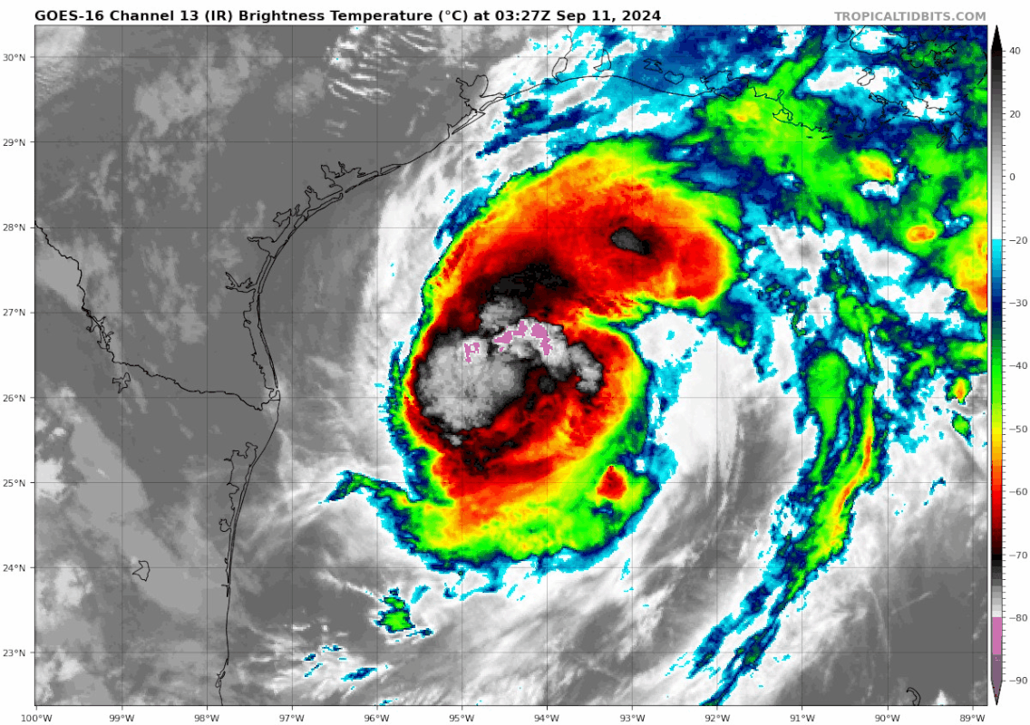
Here's our -90ºC cloud tops making their first appearance I believe:

1 likes
-
ElectricStorm

- Category 5
- Posts: 5153
- Age: 25
- Joined: Tue Aug 13, 2019 11:23 pm
- Location: Norman, OK
Re: ATL: FRANCINE - Hurricane - Discussion
BULLETIN
Hurricane Francine Intermediate Advisory Number 10A
NWS National Hurricane Center Miami FL AL062024
100 AM CDT Wed Sep 11 2024
...FRANCINE A LITTLE STRONGER...
...LIFE-THREATENING STORM SURGE AND HURRICANE-FORCE WINDS EXPECTED
TO BEGIN IN LOUISIANA LATER TODAY...
SUMMARY OF 100 AM CDT...0600 UTC...INFORMATION
----------------------------------------------
LOCATION...26.6N 94.1W
ABOUT 195 MI...315 KM ENE OF MOUTH OF THE RIO GRANDE
ABOUT 275 MI...445 KM SW OF MORGAN CITY LOUISIANA
MAXIMUM SUSTAINED WINDS...90 MPH...150 KM/H
PRESENT MOVEMENT...NE OR 35 DEGREES AT 10 MPH...17 KM/H
MINIMUM CENTRAL PRESSURE...977 MB...28.85 INCHES
4 likes
B.S Meteorology, University of Oklahoma '25
Please refer to the NHC, NWS, or SPC for official information.
Please refer to the NHC, NWS, or SPC for official information.

Re: ATL: FRANCINE - Hurricane - Discussion
ElectricStorm wrote:BULLETIN
Hurricane Francine Intermediate Advisory Number 10A
NWS National Hurricane Center Miami FL AL062024
100 AM CDT Wed Sep 11 2024
...FRANCINE A LITTLE STRONGER...
...LIFE-THREATENING STORM SURGE AND HURRICANE-FORCE WINDS EXPECTED
TO BEGIN IN LOUISIANA LATER TODAY...
SUMMARY OF 100 AM CDT...0600 UTC...INFORMATION
----------------------------------------------
LOCATION...26.6N 94.1W
ABOUT 195 MI...315 KM ENE OF MOUTH OF THE RIO GRANDE
ABOUT 275 MI...445 KM SW OF MORGAN CITY LOUISIANA
MAXIMUM SUSTAINED WINDS...90 MPH...150 KM/H
PRESENT MOVEMENT...NE OR 35 DEGREES AT 10 MPH...17 KM/H
MINIMUM CENTRAL PRESSURE...977 MB...28.85 INCHES
Not only has Francine already achieved the forecast intensity for 12z six hours in advance, but she's also knocking on the door of Cat 2 with just 5 kts to go.
Eye showing up on IR:
2 likes
TC naming lists: retirements and intensity
Most aggressive Advisory #1's in North Atlantic (cr. kevin for starting the list)
Most aggressive Advisory #1's in North Atlantic (cr. kevin for starting the list)

Re: ATL: FRANCINE - Hurricane - Discussion
storm_in_a_teacup wrote:I was hoping it would move east to avoid my family in Houston. Turns out I hoped too hard because now it's so far east it's gonna hit me
Will this be your first? If so, make sure you're not in a flooding prone area and that you're in a solid safe structure
0 likes
Andy D
(For official information, please refer to the NHC and NWS products.)
(For official information, please refer to the NHC and NWS products.)
-
MarioProtVI
- Category 5
- Posts: 1039
- Age: 24
- Joined: Sun Sep 29, 2019 7:33 pm
- Location: New Jersey
Re: ATL: FRANCINE - Hurricane - Discussion
Next recon should be very interesting. Most likely will find a C2 but can’t rule it some BS and it’s stronger then that.
0 likes
-
xtyphooncyclonex

- Category 5
- Posts: 3898
- Age: 24
- Joined: Sat Dec 08, 2012 9:07 am
- Location: Cebu City
- Contact:
Re: ATL: FRANCINE - Hurricane - Discussion
Not doubting Francine's intensity at all, but she's kind of an ugly-looking system...
1 likes
REMINDER: My opinions that I, or any other NON Pro-Met in this forum, are unofficial. Please do not take my opinions as an official forecast and warning. I am NOT a meteorologist. Following my forecasts blindly may lead to false alarm, danger and risk if official forecasts from agencies are ignored.

Re: ATL: FRANCINE - Hurricane - Discussion
Ugly like a witch and potent enough to beat someone’s butt!xtyphooncyclonex wrote:Not doubting Francine's intensity at all, but she's kind of an ugly-looking system...
0 likes

Re: ATL: FRANCINE - Hurricane - Discussion
Looks like 4500 CAPE in the core. Hard to read the current graphics.
40kt jet over head.
Its a battle between shear and strong infeed.
Last eyedrop from recon at 4:42Z showed a relatively dry core.
New eyedrop is coming up in a few minutes.
40kt jet over head.
Its a battle between shear and strong infeed.
Last eyedrop from recon at 4:42Z showed a relatively dry core.
New eyedrop is coming up in a few minutes.
2 likes
Re: ATL: FRANCINE - Hurricane - Discussion
Large, widespread helicity at the core.
Looks very likely this will be a large tornado outbreak event.
Looks very likely this will be a large tornado outbreak event.
2 likes
-
Hurricane2022
- Category 5
- Posts: 2092
- Joined: Tue Aug 23, 2022 11:38 pm
- Location: Araçatuba, Brazil
Re: ATL: FRANCINE - Hurricane - Discussion
Extrap 969.2 so far
3 likes
Sorry for the bad English sometimes...!
For reliable and detailed information for any meteorological phenomenon, please consult the National Hurricane Center, Joint Typhoon Warning Center , or your local Meteo Center.
--------
ECCE OMNIA NOVA FACIAM (Ap 21,5).
For reliable and detailed information for any meteorological phenomenon, please consult the National Hurricane Center, Joint Typhoon Warning Center , or your local Meteo Center.
--------
ECCE OMNIA NOVA FACIAM (Ap 21,5).
Who is online
Users browsing this forum: No registered users and 48 guests