In fact it would be TS since it is already at 45 kt
ATL: FRANCINE - Remnants - Discussion
Moderator: S2k Moderators
-
Hurricane2022

- Category 5

- Posts: 2092
- Joined: Tue Aug 23, 2022 11:38 pm
- Location: Araçatuba, Brazil
Re: ATL: SIX - Potential Tropical Cyclone - Discussion
In fact it would be TS since it is already at 45 kt
1 likes
Sorry for the bad English sometimes...!
For reliable and detailed information for any meteorological phenomenon, please consult the National Hurricane Center, Joint Typhoon Warning Center , or your local Meteo Center.
--------
ECCE OMNIA NOVA FACIAM (Ap 21,5).
For reliable and detailed information for any meteorological phenomenon, please consult the National Hurricane Center, Joint Typhoon Warning Center , or your local Meteo Center.
--------
ECCE OMNIA NOVA FACIAM (Ap 21,5).
Re: ATL: SIX - Potential Tropical Cyclone - Discussion
The updated track at 10 pm will have a 70-kt hurricane by Wednesday morning and landfall a tick east of Lake Charles around 7 pm Wednesday evening at 70 kts.
1 likes
-
DunedinDave
- Category 1

- Posts: 269
- Joined: Fri Aug 25, 2023 10:31 am
Re: ATL: SIX - Potential Tropical Cyclone - Discussion
Gotta give ICON credit on this one. They had been on this for about a week now and not budging. Everyone else was late to the party.
2 likes

Re: ATL: SIX - Potential Tropical Cyclone - Discussion
DunedinDave wrote:Gotta give ICON credit on this one. They had been on this for about a week now and not budging. Everyone else was late to the party.
Same with Beryl.
2 likes
-
Hypercane_Kyle

- Category 5
- Posts: 3465
- Joined: Sat Mar 07, 2015 7:58 pm
- Location: Cape Canaveral, FL
Re: ATL: SIX - Potential Tropical Cyclone - Discussion
Hurricane2022 wrote:
In fact it would be TS since it is already at 45 kt
Yeah, that’s true.
0 likes
My posts are my own personal opinion, defer to the National Hurricane Center (NHC) and other NOAA products for decision making during hurricane season.
-
Tailgater33
- Tropical Depression

- Posts: 94
- Joined: Thu Jun 02, 2022 9:15 am
Re: ATL: SIX - Potential Tropical Cyclone - Discussion
wx98 wrote:The updated track at 10 pm will have a 70-kt hurricane by Wednesday morning and landfall a tick east of Lake Charles around 7 pm Wednesday evening at 70 kts.
I hope you have good sources cuz I don’t see it on the NHC site. I know you are an experienced poster so please forgive me.
1 likes
-
Hurricane Mike
- Category 2

- Posts: 675
- Joined: Tue Apr 10, 2018 7:44 am
Re: ATL: SIX - Potential Tropical Cyclone - Discussion
Video Update on the system
https://www.youtube.com/watch?v=SLqRPLTG-Bk
https://www.youtube.com/watch?v=SLqRPLTG-Bk
0 likes

Re: ATL: SIX - Potential Tropical Cyclone - Discussion
Tailgater33 wrote:wx98 wrote:The updated track at 10 pm will have a 70-kt hurricane by Wednesday morning and landfall a tick east of Lake Charles around 7 pm Wednesday evening at 70 kts.
I hope you have good sources cuz I don’t see it on the NHC site. I know you are an experienced poster so please forgive me.
That's what I've seen, they are expecting it to continue strengthening until landfall around Pecan Island.
0 likes
Personal Forecast Disclaimer:
The posts in this forum are NOT official forecast and should not be used as such. They are just the opinion of the poster and may or may not be backed by sound meteorological data. They are NOT endorsed by any professional institution or storm2k.org. For official information, please refer to the NHC and NWS products.
The posts in this forum are NOT official forecast and should not be used as such. They are just the opinion of the poster and may or may not be backed by sound meteorological data. They are NOT endorsed by any professional institution or storm2k.org. For official information, please refer to the NHC and NWS products.
-
MGC

- S2K Supporter

- Posts: 5941
- Joined: Sun Mar 23, 2003 9:05 pm
- Location: Pass Christian MS, or what is left.
Re: ATL: SIX - Potential Tropical Cyclone - Discussion
0Z GFS and ICON both landfall near Vermillion Bay as a hurricane. GFS much stronger than ICON. If other models follow tonight and 06Z I would expect the NHC to nudge the track eastward. We shall see.....MGC
2 likes
Re: ATL: SIX - Potential Tropical Cyclone - Discussion
Tailgater33 wrote:wx98 wrote:The updated track at 10 pm will have a 70-kt hurricane by Wednesday morning and landfall a tick east of Lake Charles around 7 pm Wednesday evening at 70 kts.
I hope you have good sources cuz I don’t see it on the NHC site. I know you are an experienced poster so please forgive me.
The source was the NHC…
2 likes
Re: ATL: SIX - Potential Tropical Cyclone - Discussion
MGC wrote:0Z GFS and ICON both landfall near Vermillion Bay as a hurricane. GFS much stronger than ICON. If other models follow tonight and 06Z I would expect the NHC to nudge the track eastward. We shall see.....MGC
Agree. I think more the central Louisiana coastline will be in play here.
0 likes
-
Sciencerocks
- Category 5
- Posts: 10193
- Age: 40
- Joined: Thu Jul 06, 2017 1:51 am


Re: ATL: SIX - Potential Tropical Cyclone - Discussion
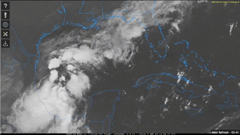
Not sure if Recon will find a well defined LLC yet.

0 likes
-
REDHurricane

- Category 1
- Posts: 438
- Age: 28
- Joined: Sun Jul 03, 2022 2:36 pm
- Location: Northeast Pacific Ocean
Re: ATL: SIX - Potential Tropical Cyclone - Discussion
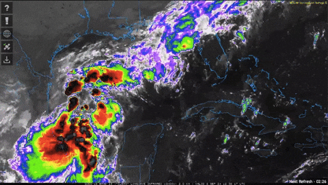
Ok it's starting to look like it wants to become a hurricane now, and at the end of these loops it appears that an LLC might be trying to consolidate underneath those bursts of convection popping up near 21-22ºN, 95ºW:
1 likes

Re: ATL: SIX - Potential Tropical Cyclone - Discussion
What happened to the theory that the basin can't produce any thunderstorms because the tropopause is too warm?
3 likes
TC naming lists: retirements and intensity
Most aggressive Advisory #1's in North Atlantic (cr. kevin for starting the list)
Most aggressive Advisory #1's in North Atlantic (cr. kevin for starting the list)

-
wxman57

- Moderator-Pro Met

- Posts: 23175
- Age: 68
- Joined: Sat Jun 21, 2003 8:06 pm
- Location: Houston, TX (southwest)
Re: ATL: SIX - Potential Tropical Cyclone - Discussion
Near Vermilion Bay, who would have thought? I see those frontal winds down the coast of MX are down to about 30-35 kts today, as expected. An LLC should develop later today with winds of 30-35 kts. On track for a Wed afternoon landfall near Vermilion Bay or possibly east of there. Models are always too far west with such systems.
1 likes

Re: ATL: SIX - Potential Tropical Cyclone - Discussion
REDHurricane wrote:Ok it's starting to look like it wants to become a hurricane now, and at the end of these loops it appears that an LLC might be trying to consolidate underneath those bursts of convection popping up near 21-22ºN, 95ºW:
https://media3.giphy.com/media/v1.Y2lkPTc5MGI3NjExdnkwNXNxZGhjYWJtYmdueXIwNXlpOTBpN2kzaHhvczVkcHdqNXh3ZyZlcD12MV9pbnRlcm5hbF9naWZfYnlfaWQmY3Q9Zw/aUzWwMQurji7gfTCIZ/giphy.gif
https://media4.giphy.com/media/v1.Y2lkPTc5MGI3NjExZ3V1dzM5Z2M4YzA1MmxpdXNzaGRibXU2bmpjeThjaTNmdWQ1Z3AxcCZlcD12MV9pbnRlcm5hbF9naWZfYnlfaWQmY3Q9Zw/Nc3IVvfDH3I77DCFis/giphy.gif
https://media2.giphy.com/media/v1.Y2lkPTc5MGI3NjExOW4xNjF1bnRrYmp1MXh1YXF3dTBjczJqbmk5end3MDRmcWprbHJ4NiZlcD12MV9pbnRlcm5hbF9naWZfYnlfaWQmY3Q9Zw/wS24xjGVtc3lk9M2yH/giphy.gif
Pressures starting to drop at the Bay of Campeche buoy.
I think consolidation is underway
https://www.ndbc.noaa.gov/station_page. ... tion=42055
1 likes
-
TomballEd
- Category 5
- Posts: 1322
- Age: 62
- Joined: Wed Aug 16, 2023 4:52 pm
- Location: Spring/Klein area, not Tomball
Re: ATL: SIX - Potential Tropical Cyclone - Discussion
Convection near the center has started to blossom although there is still a lot of convection NW of the center which is probably slowing intensification.
There is still no defined center, I understand that as far as uncertainty, but with the low level invest mission as part of the data for the models and model agreement on landfall location is pretty good, with GFS and Euro ensembles near Vermillion Bay, noting the pro-met on models often not being far enough E, I think NHC forecast is pretty good although it may get shifted further E. St. Mary or Terrebonne Parish. I've flown out of Patterson and Morgan City fairly often in the day.
In Louisiana, Rob Perillo was the best TV met in the late 1990s and is still working today. KATC TV 3 and the LCH NWS office and NHC are the best sources for Acadiana weather.
4 likes
-
WaveBreaking

- Category 2
- Posts: 728
- Joined: Sun Jun 30, 2024 11:33 am
- Location: US
Re: ATL: SIX - Potential Tropical Cyclone - Discussion
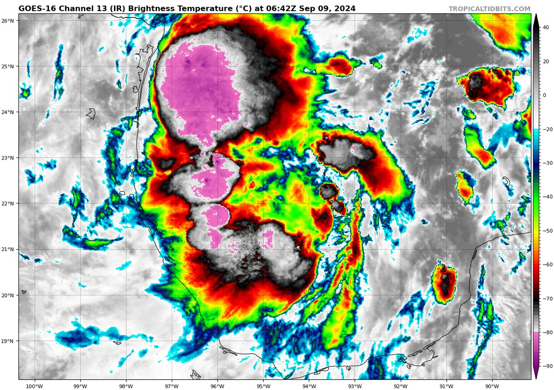
The cold tops on this could put some WPAC invests to shame. I see multiple -90C overshooting tops in this loop 
EDIT: Also the most recent burst of convection is nearly right over where the NHC has the center at (22N 94.7W).

EDIT: Also the most recent burst of convection is nearly right over where the NHC has the center at (22N 94.7W).
4 likes
I am NOT a professional meteorologist, so take all of my posts with a grain of salt. My opinions are mine and mine alone.
Who is online
Users browsing this forum: No registered users and 56 guests