
12W YAGI 240905 0000 19.0N 115.8E WPAC 140 916
WPAC: YAGI - Post-Tropical
Moderator: S2k Moderators
-
doomhaMwx

- Category 5

- Posts: 2492
- Age: 27
- Joined: Tue Apr 18, 2017 4:01 am
- Location: Baguio/Benguet, Philippines
- Contact:
Re: WPAC: YAGI - Typhoon
916 mb recorded by the buoy in the eye. Wow!
https://x.com/doomhaMwx/status/1831949332666626497
https://x.com/FansOfStorms/status/1831957108298019304
https://x.com/doomhaMwx/status/1831949332666626497
https://x.com/FansOfStorms/status/1831957108298019304
Last edited by doomhaMwx on Fri Sep 06, 2024 2:34 am, edited 1 time in total.
2 likes
-
doomhaMwx
- Category 5
- Posts: 2492
- Age: 27
- Joined: Tue Apr 18, 2017 4:01 am
- Location: Baguio/Benguet, Philippines
- Contact:
Re: WPAC: YAGI - Typhoon
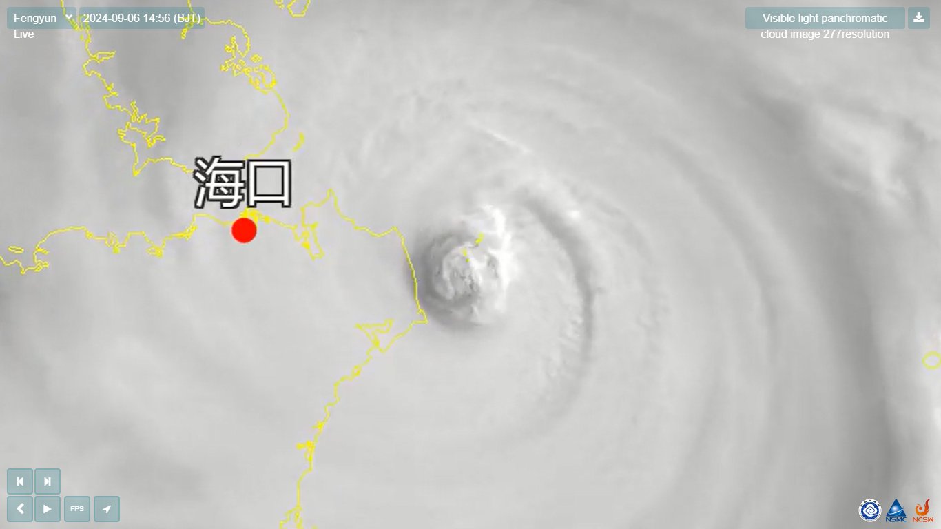
The Quizhou Islands are now partially in the eye as per satellite and radar. Landfall will occur over "Mainland" Hainan any moment now.
1 likes

Re: WPAC: YAGI - Super Typhoon
A 05/2245Z SMAP pass reveals a converted 134 kt 1 min winds, maybe the 06/00z fix needs also be adjusted? (currently 130 kts)
WP, 12, 202409052245, 30, SMAP, IR, , 1920N, 11220E, , 1, 125, 1, , , , 34, NEQ, 0, 0, 0, 0, , , , , 1, 0, , W, NASA, RSS, , , , , , , , , , , , , , , , , , , , , , , , , , , , 1, max. wind is 10 minute sustained
WP, 12, 202409052245, 30, SMAP, IR, , 1920N, 11220E, , 1, 125, 1, , , , 50, NEQ, 0, 128, 0, 0, , , , , 1, 0, , W, NASA, RSS, , , , , , , , , , , , , , , , , , , , , , , , , , , , 1, max. wind is 10 minute sustained
WP, 12, 202409052245, 30, SMAP, IR, , 1920N, 11220E, , 1, 125, 1, , , , 64, NEQ, 74, 75, 0, 0, , , , , 1, 0, , W, NASA, RSS, , , , , , , , , , , , , , , , , , , , , , , , , , , , 1, max. wind is 10 minute sustained
0 likes
ヤンデレ女が寝取られるているのを見たい!!!
ECMWF ensemble NWPAC plots: https://ecmwfensnwpac.imgbb.com/
Multimodel NWPAC plots: https://multimodelnwpac.imgbb.com/
GFS Ensemble NWPAC plots (16 & 35 day forecast): https://gefsnwpac.imgbb.com/
Plots updated automatically
ECMWF ensemble NWPAC plots: https://ecmwfensnwpac.imgbb.com/
Multimodel NWPAC plots: https://multimodelnwpac.imgbb.com/
GFS Ensemble NWPAC plots (16 & 35 day forecast): https://gefsnwpac.imgbb.com/
Plots updated automatically
-
mrbagyo

- Category 5
- Posts: 3984
- Age: 33
- Joined: Thu Apr 12, 2012 9:18 am
- Location: 14.13N 120.98E
- Contact:
Re: WPAC: YAGI - Typhoon
LANDFALL!
0 likes
The posts in this forum are NOT official forecast and should not be used as such. They are just the opinion of the poster and may or may not be backed by sound meteorological data. They are NOT endorsed by any professional institution or storm2k.org. For official information, please refer to RSMC, NHC and NWS products.
-
mrbagyo
- Category 5
- Posts: 3984
- Age: 33
- Joined: Thu Apr 12, 2012 9:18 am
- Location: 14.13N 120.98E
- Contact:
Re: WPAC: YAGI - Typhoon
0 likes
The posts in this forum are NOT official forecast and should not be used as such. They are just the opinion of the poster and may or may not be backed by sound meteorological data. They are NOT endorsed by any professional institution or storm2k.org. For official information, please refer to RSMC, NHC and NWS products.

Re: WPAC: YAGI - Typhoon
A blend of the 6 intensity estimates gives a landfall intensity of 922 mb, 125 kt. This is fairly in-line with JTWC's landfall intensity of 928 mb, 125 kt. Based on the 922 mb measurement made on the ground the 922 mb estimate is more accurate and the true landfall pressure might've even been a bit lower around 920 mb. Either way, China doesn't often see a direct cat 4 landfall. Yagi is the most intense landfall in China since Rammasun in 2014.
0 likes
-
doomhaMwx
- Category 5
- Posts: 2492
- Age: 27
- Joined: Tue Apr 18, 2017 4:01 am
- Location: Baguio/Benguet, Philippines
- Contact:
Re: WPAC: YAGI - Typhoon
0 likes
-
mrbagyo
- Category 5
- Posts: 3984
- Age: 33
- Joined: Thu Apr 12, 2012 9:18 am
- Location: 14.13N 120.98E
- Contact:
Re: WPAC: YAGI - Typhoon
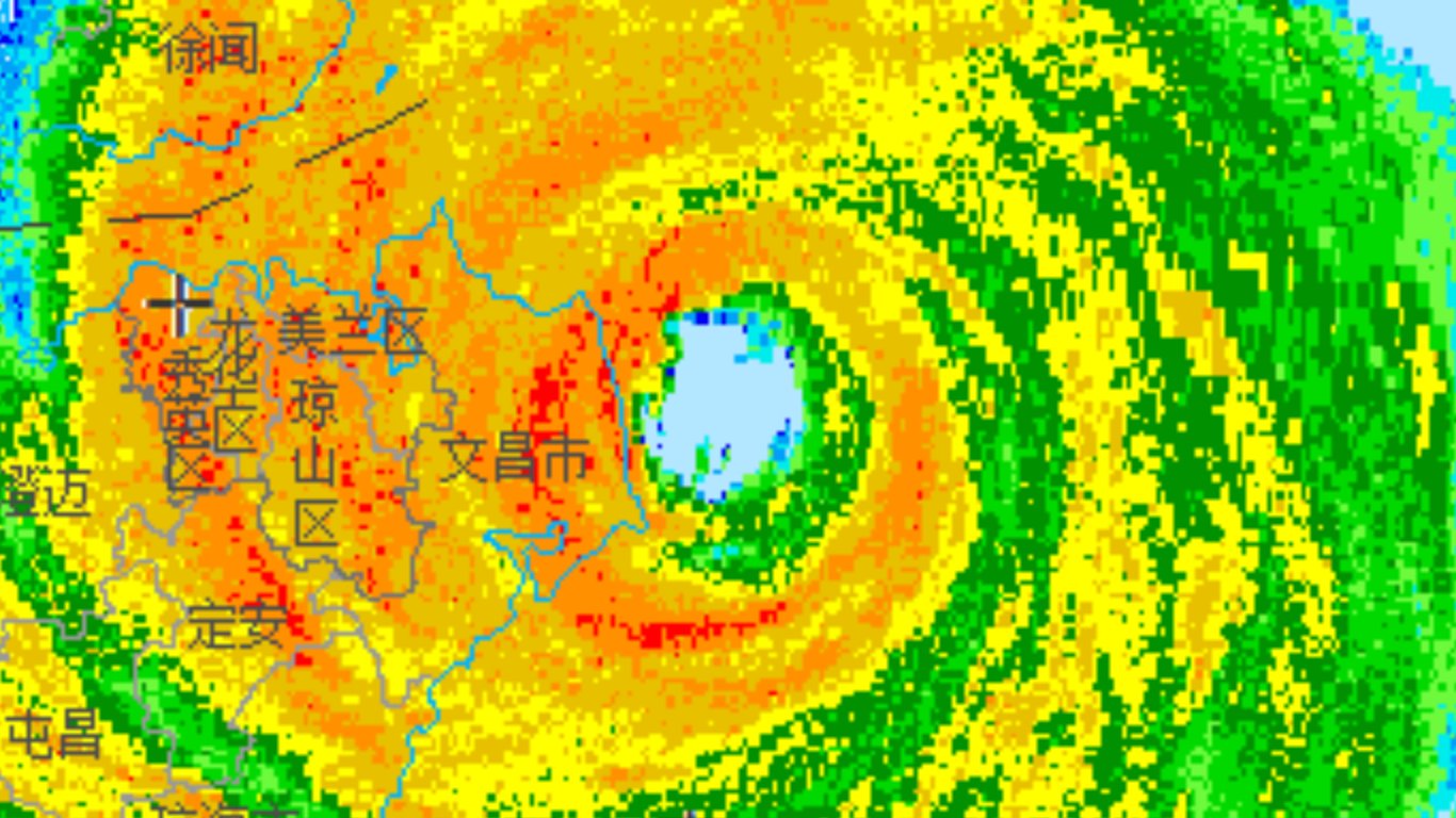
Haikou - 928 hPa
ZJHK 061100Z 01003MPS 3000 R09///// R10/P2000 SHRA SCT010 SCT026CB SCT026 25/25 Q0928 BECMG TL1200 25020G35MPS 1000 +SHRA
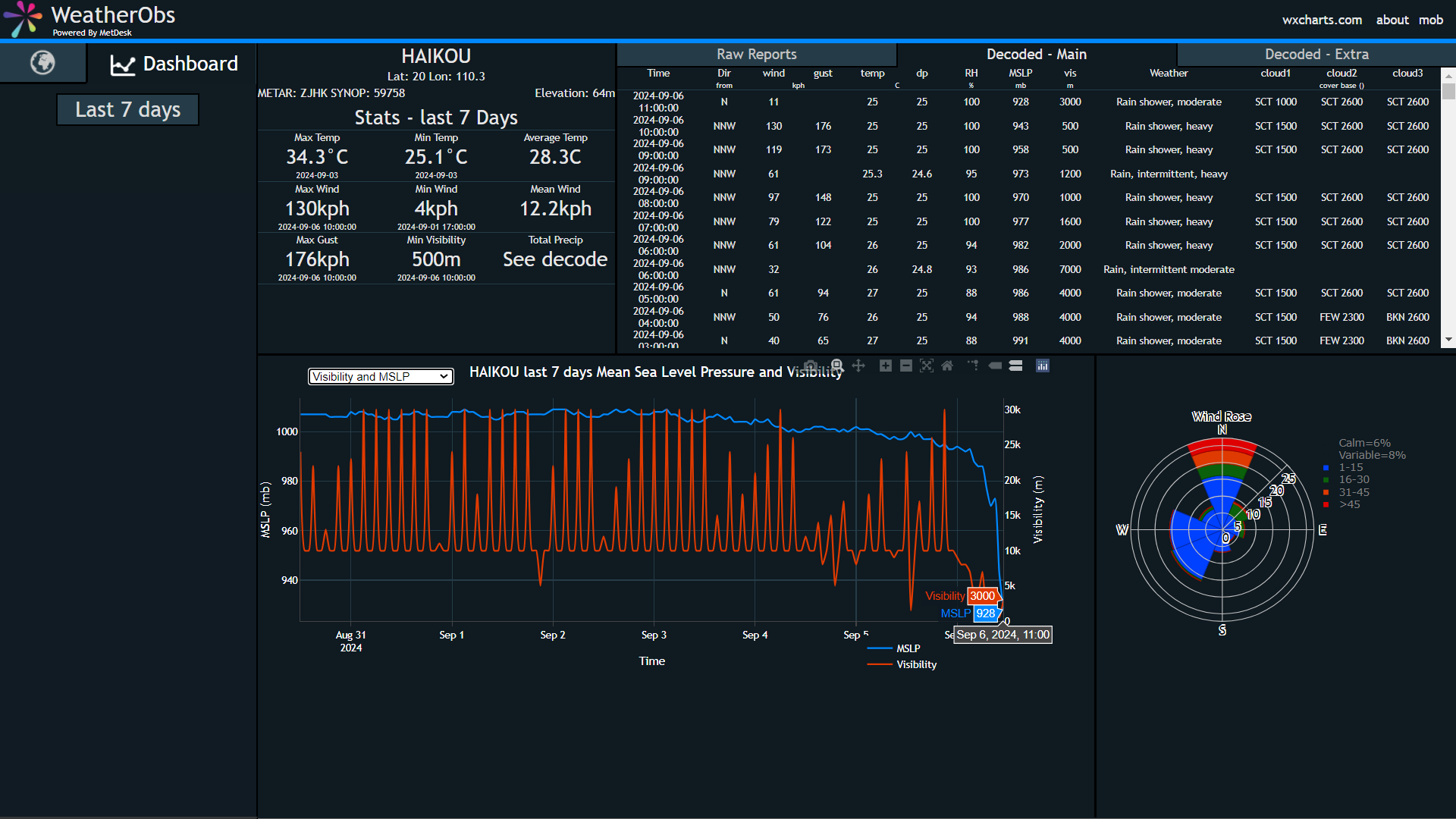
ZJHK 061100Z 01003MPS 3000 R09///// R10/P2000 SHRA SCT010 SCT026CB SCT026 25/25 Q0928 BECMG TL1200 25020G35MPS 1000 +SHRA
0 likes
The posts in this forum are NOT official forecast and should not be used as such. They are just the opinion of the poster and may or may not be backed by sound meteorological data. They are NOT endorsed by any professional institution or storm2k.org. For official information, please refer to RSMC, NHC and NWS products.

Re: WPAC: YAGI - Typhoon
HAFS-A is predicting an extremely severe Vietnam landfall with major impacts on Hanoi.
0 likes
-
xtyphooncyclonex

- Category 5
- Posts: 3898
- Age: 24
- Joined: Sat Dec 08, 2012 9:07 am
- Location: Cebu City
- Contact:
Re: WPAC: YAGI - Typhoon
0 likes
REMINDER: My opinions that I, or any other NON Pro-Met in this forum, are unofficial. Please do not take my opinions as an official forecast and warning. I am NOT a meteorologist. Following my forecasts blindly may lead to false alarm, danger and risk if official forecasts from agencies are ignored.
-
doomhaMwx
- Category 5
- Posts: 2492
- Age: 27
- Joined: Tue Apr 18, 2017 4:01 am
- Location: Baguio/Benguet, Philippines
- Contact:
Re: WPAC: YAGI - Typhoon
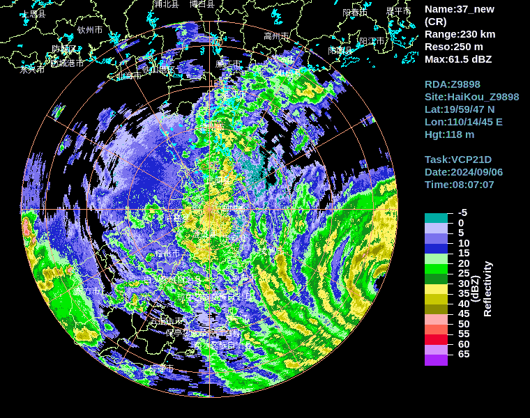
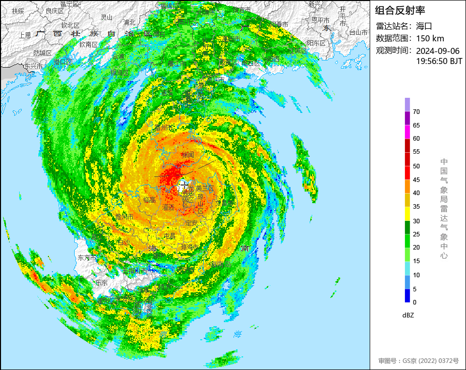
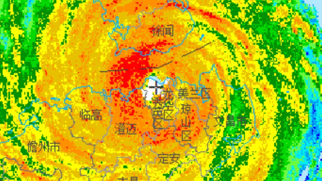
Eye currently directly passing over the weather radar site in Haikou City!
0 likes
Re: WPAC: YAGI - Typhoon
Haikou City measured an hourly pressure at 7:00PM of 27.33 in -> 925.5 mb (https://www.wunderground.com/history/daily/cn/haikou/ZJHK).
0 likes
-
MarioProtVI
- Category 5
- Posts: 1038
- Age: 24
- Joined: Sun Sep 29, 2019 7:33 pm
- Location: New Jersey
Re: WPAC: YAGI - Super Typhoon
Subtrop wrote:12W YAGI 240905 0000 19.0N 115.8E WPAC 140 916
Only the fourth in the SCS after Pamela ‘54, Rammasun ‘14 and Rai ‘21. This feels like the WPac’s version of Beryl this year. Pretty wild.
0 likes
-
xtyphooncyclonex
- Category 5
- Posts: 3898
- Age: 24
- Joined: Sat Dec 08, 2012 9:07 am
- Location: Cebu City
- Contact:
Re: WPAC: YAGI - Typhoon
If the 140 kt estimate was before the first EWRC ended, the second peak may have even been stronger.
1 likes
REMINDER: My opinions that I, or any other NON Pro-Met in this forum, are unofficial. Please do not take my opinions as an official forecast and warning. I am NOT a meteorologist. Following my forecasts blindly may lead to false alarm, danger and risk if official forecasts from agencies are ignored.
-
cycloneye

- Admin

- Posts: 149670
- Age: 69
- Joined: Thu Oct 10, 2002 10:54 am
- Location: San Juan, Puerto Rico
Re: WPAC: YAGI - Typhoon
0 likes
Visit the Caribbean-Central America Weather Thread where you can find at first post web cams,radars
and observations from Caribbean basin members Click Here
and observations from Caribbean basin members Click Here
-
mrbagyo
- Category 5
- Posts: 3984
- Age: 33
- Joined: Thu Apr 12, 2012 9:18 am
- Location: 14.13N 120.98E
- Contact:
Re: WPAC: YAGI - Typhoon
Gulf of Tonkin is plenty warm so Yagi might regain some of its convective juice.
The gulf is also a relatively shallow body of water so If this typhoon moves to just south of the Red River Delta, we would be looking at a potential historic storm surge event in a populated area.
The gulf is also a relatively shallow body of water so If this typhoon moves to just south of the Red River Delta, we would be looking at a potential historic storm surge event in a populated area.
0 likes
The posts in this forum are NOT official forecast and should not be used as such. They are just the opinion of the poster and may or may not be backed by sound meteorological data. They are NOT endorsed by any professional institution or storm2k.org. For official information, please refer to RSMC, NHC and NWS products.

Re: WPAC: YAGI - Typhoon
mrbagyo wrote:Gulf of Tonkin is plenty warm so Yagi might regain some of its convective juice.
The gulf is also a relatively shallow body of water so If this typhoon moves to just south of the Red River Delta, we would be looking at a potential historic storm surge event in a populated area.
https://s1.gifyu.com/images/S1Ivj.png
I was just going to mention this, any southward deviations would lead to catastrophic storm surge in the Red Delta and major typhoon impacts for the city of Hanoi. Hopefully this misses to the north
0 likes
-
CrazyC83
- Professional-Met

- Posts: 34316
- Joined: Tue Mar 07, 2006 11:57 pm
- Location: Deep South, for the first time!
Re: WPAC: YAGI - Typhoon
There's been some pretty good measurements that can provide good estimates for the intensity. The Hong Kong recon supported 926 mb during the first ERC, and the buoy reading supporting 914 mb plus the landfall pressure data (I heard a school had a 922 reading, but wasn't sure the surface winds at the time).
The peak intensity I think was 145 kt (1-min) at 0300Z (non-synoptic time), at the time of the buoy reading of 916/20. Landfall (at about 0715Z) I would estimate at 140 kt with a pressure of 920 mb.
The peak intensity I think was 145 kt (1-min) at 0300Z (non-synoptic time), at the time of the buoy reading of 916/20. Landfall (at about 0715Z) I would estimate at 140 kt with a pressure of 920 mb.
0 likes
Who is online
Users browsing this forum: No registered users and 72 guests