WPAC: YAGI - Post-Tropical
Moderator: S2k Moderators

Re: WPAC: YAGI - Typhoon
Based on a blend of ADT, AiDT and DPRINT I'd put the current intensity at 945 mb, 100 kt. It already has the look of a cat 4, just a matter of time before satellite images stabalize long enough & winds mix down and then ADT will also support it. Using this intensity would make the current ERI of Yagi one of the fastest of the year, 50 kt over the last 24 hours (just below Beryl).
0 likes
-
REDHurricane

- Category 1

- Posts: 438
- Age: 28
- Joined: Sun Jul 03, 2022 2:36 pm
- Location: Northeast Pacific Ocean
Re: WPAC: YAGI - Typhoon
It seemed about time for the northern hemisphere to produce a real monster or two, all that energy has to go somewhere
0 likes
-
cycloneye

- Admin

- Posts: 149672
- Age: 69
- Joined: Thu Oct 10, 2002 10:54 am
- Location: San Juan, Puerto Rico
Re: WPAC: YAGI - Typhoon
Up to cat 3.

12W YAGI 240904 1200 19.2N 116.9E WPAC 110 968
0 likes
Visit the Caribbean-Central America Weather Thread where you can find at first post web cams,radars
and observations from Caribbean basin members Click Here
and observations from Caribbean basin members Click Here
-
xtyphooncyclonex

- Category 5

- Posts: 3898
- Age: 24
- Joined: Sat Dec 08, 2012 9:07 am
- Location: Cebu City
- Contact:
Re: WPAC: YAGI - Typhoon
Yagi looks to be on the wrong side of the Philippines. This isn't exactly a common sight.
We may wake up to a category 5.

We may wake up to a category 5.
2 likes
REMINDER: My opinions that I, or any other NON Pro-Met in this forum, are unofficial. Please do not take my opinions as an official forecast and warning. I am NOT a meteorologist. Following my forecasts blindly may lead to false alarm, danger and risk if official forecasts from agencies are ignored.
-
WaveBreaking

- Category 2

- Posts: 727
- Joined: Sun Jun 30, 2024 11:33 am
- Location: US
Re: WPAC: YAGI - Typhoon

1 likes
I am NOT a professional meteorologist, so take all of my posts with a grain of salt. My opinions are mine and mine alone.
-
WaveBreaking
- Category 2
- Posts: 727
- Joined: Sun Jun 30, 2024 11:33 am
- Location: US
Re: WPAC: YAGI - Typhoon
Polygonal eye currently. Mesovorticies will start mixing higher winds soon.

0 likes
I am NOT a professional meteorologist, so take all of my posts with a grain of salt. My opinions are mine and mine alone.
-
mrbagyo

- Category 5
- Posts: 3985
- Age: 33
- Joined: Thu Apr 12, 2012 9:18 am
- Location: 14.13N 120.98E
- Contact:
Re: WPAC: YAGI - Typhoon
HKO reportedly flew a recon mission to Yagi though it didn't penetrate the eye
https://weibo.com/5644859481/Ovtd79GDb
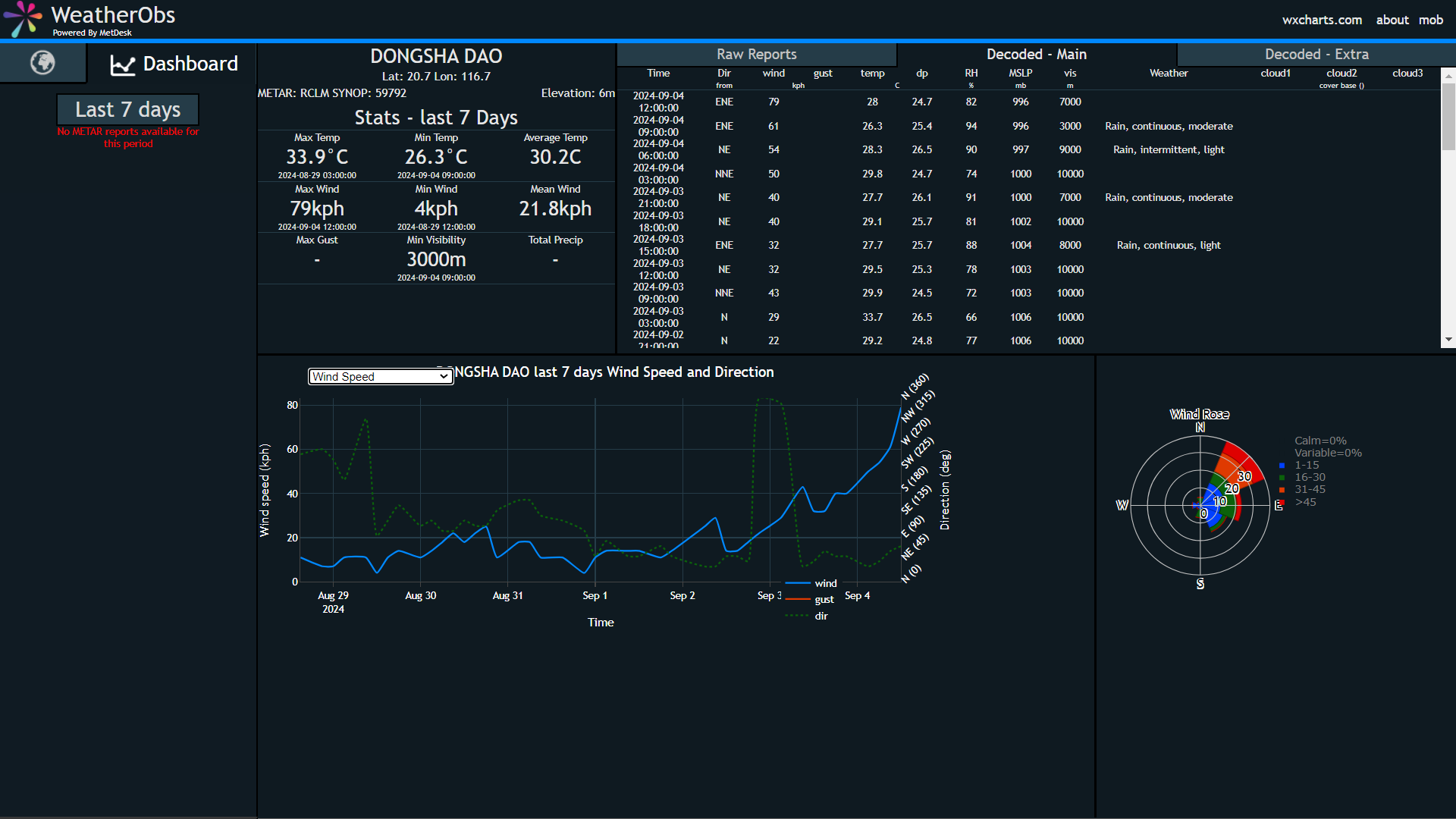
Surface Observation from Pratas Island (Dongsha)
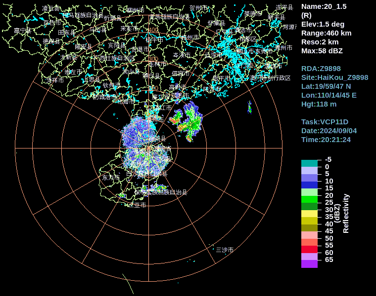
Haikou radar (460km)
https://weibo.com/5644859481/Ovtd79GDb
Surface Observation from Pratas Island (Dongsha)
Haikou radar (460km)
0 likes
The posts in this forum are NOT official forecast and should not be used as such. They are just the opinion of the poster and may or may not be backed by sound meteorological data. They are NOT endorsed by any professional institution or storm2k.org. For official information, please refer to RSMC, NHC and NWS products.
-
Kingarabian

- S2K Supporter

- Posts: 16376
- Joined: Sat Aug 08, 2009 3:06 am
- Location: Honolulu, Hawaii
Re: WPAC: YAGI - Typhoon
Easily a cat.4 now. Will need a few more hours before it can get to cat.5.
0 likes
RIP Kobe Bryant
-
WaveBreaking
- Category 2
- Posts: 727
- Joined: Sun Jun 30, 2024 11:33 am
- Location: US
Re: WPAC: YAGI - Typhoon

0 likes
I am NOT a professional meteorologist, so take all of my posts with a grain of salt. My opinions are mine and mine alone.
-
Cantdecideanalias
- Tropical Wave

- Posts: 1
- Joined: Sun Sep 01, 2024 2:02 pm
Re: WPAC: YAGI - Typhoon
mrbagyo wrote:HKO reportedly flew a recon mission to Yagi though it didn't penetrate the eye
Surface Observation from Pratas Island (Dongsha)
Central Weather Administration(CWA) of Tai Wan website had more data
https://www.cwa.gov.tw/V8/E/W/OBS_Station.html?ID=46810
Pressure chart↓
 No idea why there is no wind speed chart, through
BTW, Yagi is moving away from Dongsha station(20.7N, 116.7E), yet pressure is still dropping
0 likes
-
ElectricStorm

- Category 5
- Posts: 5150
- Age: 25
- Joined: Tue Aug 13, 2019 11:23 pm
- Location: Norman, OK
Re: WPAC: YAGI - Typhoon
Once the eye clears out should easily be a Cat 5. Probably well into Cat 4 range approaching super typhoon status right now.
0 likes
B.S Meteorology, University of Oklahoma '25
Please refer to the NHC, NWS, or SPC for official information.
Please refer to the NHC, NWS, or SPC for official information.
Re: WPAC: YAGI - Typhoon
An equal blend of the 6 intensity estimates (ADT, AiDT, DPRINT, DMINT, MW SOUNDERS, SATCON) gives an intensity of 923 mb, 125 kt. Furthermore, AI-RI (which updates a little more than 2 hours ago when the storm was assessed at 120 kt) gives a 52.4% chance of 20kt/12hr, which means a 52.4% chance of a 140 kt cat 5. There is even a 22.9% chance of 40kt/24hr, which is just insane and would amount to a 160 kt typhoon before landfall. Either way this will likely be a historic storm for the region.
0 likes
-
cycloneye
- Admin
- Posts: 149672
- Age: 69
- Joined: Thu Oct 10, 2002 10:54 am
- Location: San Juan, Puerto Rico
Re: WPAC: YAGI - Typhoon

0 likes
Visit the Caribbean-Central America Weather Thread where you can find at first post web cams,radars
and observations from Caribbean basin members Click Here
and observations from Caribbean basin members Click Here
-
Hurricane2022

- Category 5
- Posts: 2087
- Joined: Tue Aug 23, 2022 11:38 pm
- Location: Araçatuba, Brazil
Re: WPAC: YAGI - Typhoon
I Think that JTWC is being somewhat conservative in this 21z forecast. Yagi is likely going to peak at around 145 - 150 kt, not at just 130 kt. But either way this storm is going to be historic. Maybe already it is now...
0 likes
Sorry for the bad English sometimes...!
For reliable and detailed information for any meteorological phenomenon, please consult the National Hurricane Center, Joint Typhoon Warning Center , or your local Meteo Center.
--------
ECCE OMNIA NOVA FACIAM (Ap 21,5).
For reliable and detailed information for any meteorological phenomenon, please consult the National Hurricane Center, Joint Typhoon Warning Center , or your local Meteo Center.
--------
ECCE OMNIA NOVA FACIAM (Ap 21,5).
-
Hurricane2022
- Category 5
- Posts: 2087
- Joined: Tue Aug 23, 2022 11:38 pm
- Location: Araçatuba, Brazil
Re: WPAC: YAGI - Typhoon
the eye of Yagi has been warming very gradually so far. Also notice this WSW dip that Yagi has been doing in the last few frames.

0 likes
Sorry for the bad English sometimes...!
For reliable and detailed information for any meteorological phenomenon, please consult the National Hurricane Center, Joint Typhoon Warning Center , or your local Meteo Center.
--------
ECCE OMNIA NOVA FACIAM (Ap 21,5).
For reliable and detailed information for any meteorological phenomenon, please consult the National Hurricane Center, Joint Typhoon Warning Center , or your local Meteo Center.
--------
ECCE OMNIA NOVA FACIAM (Ap 21,5).
-
Hurricane2022
- Category 5
- Posts: 2087
- Joined: Tue Aug 23, 2022 11:38 pm
- Location: Araçatuba, Brazil
Re: WPAC: YAGI - Typhoon
Looks like there is some N shear affecting Yagi now, maybe that's why it is struggling to warm up his eye?

0 likes
Sorry for the bad English sometimes...!
For reliable and detailed information for any meteorological phenomenon, please consult the National Hurricane Center, Joint Typhoon Warning Center , or your local Meteo Center.
--------
ECCE OMNIA NOVA FACIAM (Ap 21,5).
For reliable and detailed information for any meteorological phenomenon, please consult the National Hurricane Center, Joint Typhoon Warning Center , or your local Meteo Center.
--------
ECCE OMNIA NOVA FACIAM (Ap 21,5).
-
Kingarabian
- S2K Supporter
- Posts: 16376
- Joined: Sat Aug 08, 2009 3:06 am
- Location: Honolulu, Hawaii
Re: WPAC: YAGI - Typhoon
Hurricane2022 wrote:the eye of Yagi has been warming very gradually so far. Also notice this WSW dip that Yagi has been doing in the last few frames.
https://imageshack.com/i/poH3PXMng
WSW dip is a precursor for ERI.
Some mid shear but it should pull through.
0 likes
RIP Kobe Bryant
-
dexterlabio
- Category 5
- Posts: 3517
- Joined: Sat Oct 24, 2009 11:50 pm
Re: WPAC: YAGI - Typhoon
That WSW dip is a classic track for these WPAC howlers, primarily due to strong East Asia subtropical ridge
0 likes
Personal Forecast Disclaimer:
The posts in this forum are NOT official forecast and should not be used as such. They are just the opinion of the poster and may or may not be backed by sound meteorological data. They are NOT endorsed by any professional institution or storm2k.org. For official information, please refer to the NHC and NWS products.
The posts in this forum are NOT official forecast and should not be used as such. They are just the opinion of the poster and may or may not be backed by sound meteorological data. They are NOT endorsed by any professional institution or storm2k.org. For official information, please refer to the NHC and NWS products.
-
WaveBreaking
- Category 2
- Posts: 727
- Joined: Sun Jun 30, 2024 11:33 am
- Location: US
Re: WPAC: YAGI - Typhoon
Sunrise


1 likes
I am NOT a professional meteorologist, so take all of my posts with a grain of salt. My opinions are mine and mine alone.
-
ElectricStorm
- Category 5
- Posts: 5150
- Age: 25
- Joined: Tue Aug 13, 2019 11:23 pm
- Location: Norman, OK
Re: WPAC: YAGI - Typhoon
Eye is clearer but the CDO is much less symmetrical on the east side. Looks like a bit of shear may be getting to it. I'd put it at 130kts for 0z.
0 likes
B.S Meteorology, University of Oklahoma '25
Please refer to the NHC, NWS, or SPC for official information.
Please refer to the NHC, NWS, or SPC for official information.
Who is online
Users browsing this forum: No registered users and 38 guests