Tropical Wave in Bay of Campeche (Is Invest 91L)
Moderator: S2k Moderators
Forum rules

The posts in this forum are NOT official forecasts and should not be used as such. They are just the opinion of the poster and may or may not be backed by sound meteorological data. They are NOT endorsed by any professional institution or STORM2K. For official information, please refer to products from the National Hurricane Center and National Weather Service.
-
Stratton23
- Category 5

- Posts: 3577
- Joined: Fri Jul 21, 2023 10:59 pm
- Location: Katy, Tx
Re: Tropical Wave in Eastern Caribbean (0/40)
MarioProTVI respectfully I disagree, the CMC, ICON, Euro AIFS, still develop this, they wont decrease development chances over one run, i have a hinch they are going to wait on the Euro/ EPS runs first
0 likes
-
Audrey2Katrina

- Category 5
- Posts: 4252
- Age: 76
- Joined: Fri Dec 23, 2005 10:39 pm
- Location: Metaire, La.
Re: Tropical Wave in Eastern Caribbean (0/40)
MarioProtVI wrote:Stratton23 wrote:GEFS has backed off on development, still a lot of uncertainty though
Virtually no model develops it anymore. I think it’s time to drop chances as the GFS was really the only one still predicting development. The BoC/Western Gulf chances are a wild card and don’t even matter if the wave buries itself into Central America. To think the EPS on August 26 was saying we’d have a hurricane north of PR or so right now which ended up trending to basically nothing is
I don't think that means a whole lot. As a resident of the central Gulf who's seen more than my share of majors hitting my area, I hope it DOES peter out. However, it could well be that once it crosses the Yucatan, those very warm waters in the Bay of Campeche could fire this thing into something nobody will want a part of. It's no guarantee, but the possibility does exist.
0 likes
Flossy 56 Audrey 57 Hilda 64* Betsy 65* Camille 69* Edith 71 Carmen 74 Bob 79 Danny 85 Elena 85 Juan 85 Florence 88 Andrew 92*, Opal 95, Danny 97, Georges 98*, Isidore 02, Lili 02, Ivan 04, Cindy 05*, Dennis 05, Katrina 05*, Gustav 08*, Isaac 12*, Nate 17, Barry 19, Cristobal 20, Marco, 20, Sally, 20, Zeta 20*, Claudette 21 IDA* 21 Francine *24
-
Stratton23
- Category 5
- Posts: 3577
- Joined: Fri Jul 21, 2023 10:59 pm
- Location: Katy, Tx
Re: Tropical Wave in Eastern Caribbean (0/40)
00z Euro is trending toward development in the Southern gulf , moves into tampico as a weak TD/TS, but thats 8-9 days out, the fact that the Euro OP run is starting to catch on to some organization is big
2 likes
Re: Tropical Wave in Eastern Caribbean (0/40)
Stratton23 wrote:00z Euro is trending toward development in the Southern gulf , moves into tampico as a weak TD/TS, but thats 8-9 days out, the fact that the Euro OP run is starting to catch on to some organization is big
Right on Que the 0z euro has a system meandering in the BOC
0 likes
-
Stratton23
- Category 5
- Posts: 3577
- Joined: Fri Jul 21, 2023 10:59 pm
- Location: Katy, Tx


Re: Tropical Wave in Eastern Caribbean (0/40)
I'm not buying it. Not until I see one of two things occur first. Either a Bonafide TD on satellite, or two or more Global models depicting a TS at their 72 hr forecast.
0 likes
Andy D
(For official information, please refer to the NHC and NWS products.)
(For official information, please refer to the NHC and NWS products.)
-
Stratton23
- Category 5
- Posts: 3577
- Joined: Fri Jul 21, 2023 10:59 pm
- Location: Katy, Tx
Re: Tropical Wave in Eastern Caribbean (0/40)
Based on the model runs overnight, their is a decent bet this is going to become francine in the BOC, the euro/ ICON/ CMC are all in agreement, thTs enough for me
1 likes

Re: Tropical Wave in Eastern Caribbean (0/40)
chaser1 wrote:I'm not buying it. Not until I see one of two things occur first. Either a Bonafide TD on satellite, or two or more Global models depicting a TS at their 72 hr forecast.
Probably the safest course until there's actually a trackable center/developed system. The models have been horrendous, and a reminder what the Euro ensembles looked like a mere 72 hours ago

1 likes
The above post is not official and should not be used as such. It is the opinion of the poster and may or may not be backed by sound meteorological data. It is not endorsed by any professional institution or storm2k.org. For official information, please refer to the NHC and NWS products.

Re: Tropical Wave in Eastern Caribbean (0/40)
The last two ICON runs show something very... interesting.
This system develops into a TD/low-end TS (let's call it Francince from now on for clarity) in 66 - 84 hrs and then makes landfall in Yucatan. Around the same time at +90 hrs a tropical system starts to consolidate close to the Mexico/US border. It is pulled south by Francine and then merges into a larger system which goes north and could become the big ominous Gulf hurricane. I don't know if this would be 1, 2 or 3 separate TCs, but it'll be interesting for sure. Also note that if this ICON run becomes reality we could be at Kirk in the naming list by September 10 (3 tropical storms in the eastern MDR, a weak TS in the subtropics and the 2 Gulf/WCar systems).

This system develops into a TD/low-end TS (let's call it Francince from now on for clarity) in 66 - 84 hrs and then makes landfall in Yucatan. Around the same time at +90 hrs a tropical system starts to consolidate close to the Mexico/US border. It is pulled south by Francine and then merges into a larger system which goes north and could become the big ominous Gulf hurricane. I don't know if this would be 1, 2 or 3 separate TCs, but it'll be interesting for sure. Also note that if this ICON run becomes reality we could be at Kirk in the naming list by September 10 (3 tropical storms in the eastern MDR, a weak TS in the subtropics and the 2 Gulf/WCar systems).
2 likes

-
WaveBreaking

- Category 2

- Posts: 728
- Joined: Sun Jun 30, 2024 11:33 am
- Location: US
Re: Tropical Wave in Eastern Caribbean (0/40)
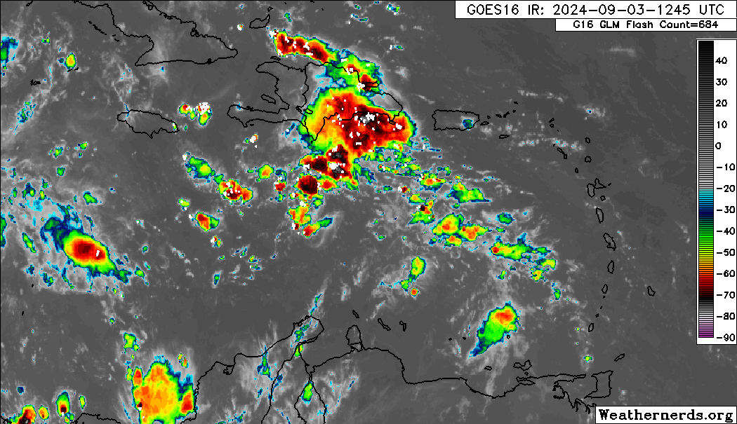
Interestingly enough, if you look at the low level clouds from 16N 65W at the beginning of the loop to 17N 73W at the end, you can see some sort of vortmax/weak circulation rushing off to the ENE that tightens up at the end of the loop. Is this the LLC that models hinted at decoupling from the MLC around this time period?

1 likes
I am NOT a professional meteorologist, so take all of my posts with a grain of salt. My opinions are mine and mine alone.

Re: Tropical Wave in Central Caribbean (0/40)
It seems that the main reason why 0z and 6z GFS doesn't develop the system -- not even in the BoC -- is that the energy gets sent to EPAC. The thing is, that makes GFS the southern outlier, as CMC and Euro both have the wave over BoC. If you extrapolate GFS's level of organization (which is still decent even if not as well-developed as previous runs) into BoC, you'd expect something to develop there.
0 likes
TC naming lists: retirements and intensity
Most aggressive Advisory #1's in North Atlantic (cr. kevin for starting the list)
Most aggressive Advisory #1's in North Atlantic (cr. kevin for starting the list)

Re: Tropical Wave in Central Caribbean (0/40)
The thing that disturbs me is the attitude of people in my area of SE Texas dismissing the rest of the season. The Spring storms and then Beryl with all of the damage, rain and loss of electricity seems to have convinced them that the season is over. It may well be and sure hope it is, but we do get majors in September and they seem to have forgotten that.
6 likes
Alicia, Rita, Ike, Harvey and Beryl...moved to Splendora lol
-
Stratton23
- Category 5
- Posts: 3577
- Joined: Fri Jul 21, 2023 10:59 pm
- Location: Katy, Tx
Re: Tropical Wave in Central Caribbean (0/40)
GFS still tries to send the energy into the pacific, im not buying this, so as for now the GFS is an outlier, the 12z CMC has shifted north in the BOC and looks similar to the 12z ICON with a developing system, a good deal more North of its 00z run
0 likes
-
LadyBug72

- Tropical Storm

- Posts: 121
- Joined: Mon Jun 01, 2020 3:39 pm
- Location: about 20 miles from Galveston, Tx
Re: Tropical Wave in Central Caribbean (0/40)
mpic wrote:The thing that disturbs me is the attitude of people in my area of SE Texas dismissing the rest of the season. The Spring storms and then Beryl with all of the damage, rain and loss of electricity seems to have convinced them that the season is over. It may well be and sure hope it is, but we do get majors in September and they seem to have forgotten that.
I am in SE Texas and agree with you on this, I think some of it has to do with the front that is supposed to move in by Sunday....I know in my experience of talking to people and belonging to weather forums etc over the years I have learned a lot of people hear the word front and automatically think hurricane season is over for our area. I can see how it can be tricky because sometimes that is the case, but I don't think they realize it has to be a strong front.
0 likes
Formerly known as the user: Nikki
Alicia 83, Allison 01, Rita 05, Ike 08, Harvey 17, Nicholas 21, Coastal Texas Derecho 24, Beryl 24
Alicia 83, Allison 01, Rita 05, Ike 08, Harvey 17, Nicholas 21, Coastal Texas Derecho 24, Beryl 24
-
Stratton23
- Category 5
- Posts: 3577
- Joined: Fri Jul 21, 2023 10:59 pm
- Location: Katy, Tx
Re: Tropical Wave in Central Caribbean (0/40)
12z CMC coming in with a strong TS into north mexico, pretty decent shift north though, im having a hard time buying the GFS as its doing weird stuff with energy from the pacific
0 likes

Re: Tropical Wave in Central Caribbean (0/40)
It seems like if this system reemerges into the BoC it has a good chance of developing. GFS has had it going into the EPac for several runs now, but most of the other globals have it in the BoC. ICON is particularly enthusiastic, showing a strengthening hurricane approaching Texas. I wouldn't discount this one yet.

0 likes
Igor 2010, Sandy 2012, Fay 2014, Gonzalo 2014, Joaquin 2015, Nicole 2016, Humberto 2019, Imelda 2025
I am only a tropical weather enthusiast. My predictions are not official and may or may not be backed by sound meteorological data. For official information, please refer to the NHC and NWS products.
I am only a tropical weather enthusiast. My predictions are not official and may or may not be backed by sound meteorological data. For official information, please refer to the NHC and NWS products.
-
Stratton23
- Category 5
- Posts: 3577
- Joined: Fri Jul 21, 2023 10:59 pm
- Location: Katy, Tx
Re: Tropical Wave in Central Caribbean (0/40)
12z euro develops and stalls in the southern gulf
0 likes
Re: Tropical Wave in Central Caribbean (0/40)
Lol...
1 likes
TC naming lists: retirements and intensity
Most aggressive Advisory #1's in North Atlantic (cr. kevin for starting the list)
Most aggressive Advisory #1's in North Atlantic (cr. kevin for starting the list)
Re: Tropical Wave in Central Caribbean (0/40)
Not unlike the tropical wave out in the Eastern MDR, this disturbance is also looking a little better early this afternoon. What any models are depicting beyond 3 days from now are irrelevant. What is relevant is what level of convection and organization this is exhibiting as the day and evening progresses. Diurnal processes notwithstanding, it is only a viable candidate for development.... if it can maintain convection. It really does come down to what we see with our own eyes. Let's see what this looks like tonight.
2 likes
Andy D
(For official information, please refer to the NHC and NWS products.)
(For official information, please refer to the NHC and NWS products.)
Who is online
Users browsing this forum: No registered users and 115 guests