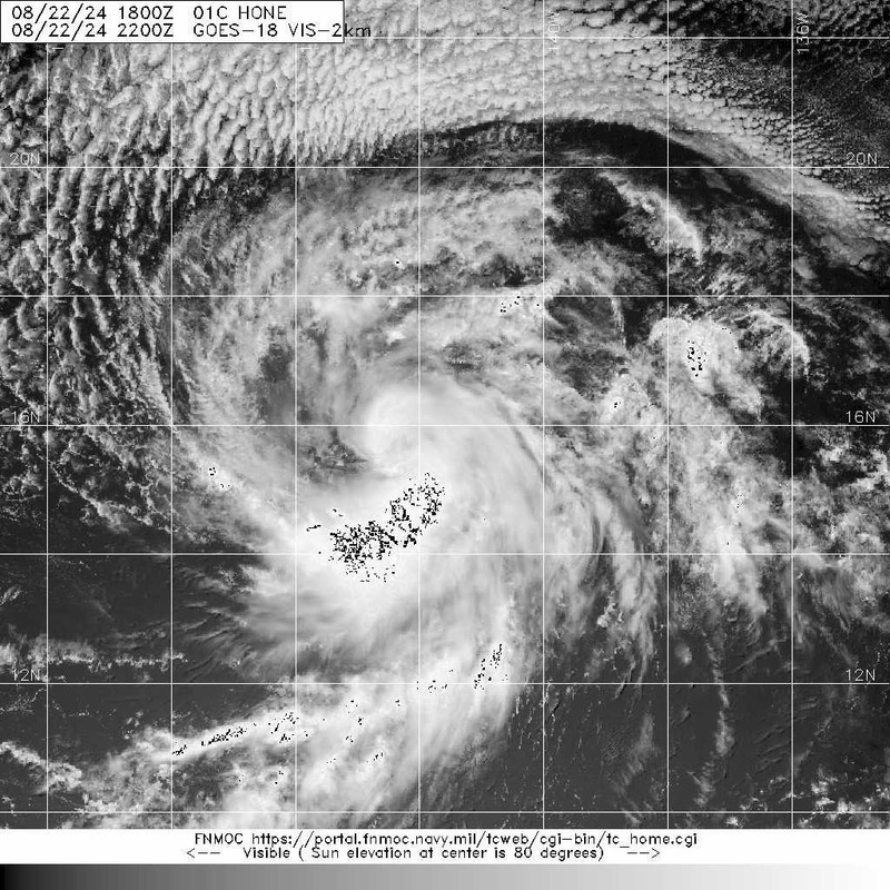
WPAC: HONE - Post-Tropical - Discussion

Moderator: S2k Moderators

Message
Author
User avatar
aspen
Category 5
Category 5
Posts: 8818
Joined: Sat Oct 12, 2019 7:10 pm
Location: Connecticut, USA

Re: CPAC: INVEST 90C - Discussion

#21 Postby aspen » Thu Aug 22, 2024 9:01 am

DorkyMcDorkface wrote:
CP, 01, 2024082212, , BEST, 0, 154N, 1403W, 30, 1005, TD

Since it’s a CPAc system, what will it be named? I can’t find the list of available CPAC names on Wikipedia.
0 likes   
Irene '11 Sandy '12 Hermine '16 5/15/2018 Derecho Fay '20 Isaias '20 Elsa '21 Henri '21 Ida '21

I am only a meteorology enthusiast who knows a decent amount about tropical cyclones. Look to the professional mets, the NHC, or your local weather office for the best information.

User avatar
DorkyMcDorkface
Category 3
Category 3
Posts: 887
Age: 27
Joined: Mon Sep 30, 2019 1:32 pm
Location: Mid-Atlantic

Re: CPAC: INVEST 90C - Discussion

#22 Postby DorkyMcDorkface » Thu Aug 22, 2024 9:04 am

aspen wrote:
DorkyMcDorkface wrote:
CP, 01, 2024082212, , BEST, 0, 154N, 1403W, 30, 1005, TD

Since it’s a CPAc system, what will it be named? I can’t find the list of available CPAC names on Wikipedia.

Next name is Hone
0 likes   
Please note the thougths expressed by this account are solely those of the user and are from a hobbyist perspective. For more comprehensive analysis, consult an actual professional meteorologist or meteorology agency.


Floyd 1999 | Isabel 2003 | Hanna 2008 | Irene 2011 | Sandy 2012 | Isaias 2020

User avatar
cycloneye
Admin
Admin
Posts: 145256
Age: 68
Joined: Thu Oct 10, 2002 10:54 am
Location: San Juan, Puerto Rico

Re: CPAC: ONE-C - Tropical Depression - Discussion

#23 Postby cycloneye » Thu Aug 22, 2024 10:02 am

BULLETIN
Tropical Depression One-C Advisory Number 1
NWS Central Pacific Hurricane Center Honolulu HI CP012024
500 AM HST Thu Aug 22 2024

...TROPICAL DEPRESSION ONE FORMS IN THE CENTRAL PACIFIC...


SUMMARY OF 500 AM HST...1500 UTC...INFORMATION
----------------------------------------------
LOCATION...15.4N 140.8W
ABOUT 985 MI...1590 KM ESE OF HILO HAWAII
ABOUT 1190 MI...1915 KM ESE OF HONOLULU HAWAII
MAXIMUM SUSTAINED WINDS...35 MPH...55 KM/H
PRESENT MOVEMENT...W OR 270 DEGREES AT 14 MPH...22 KM/H
MINIMUM CENTRAL PRESSURE...1005 MB...29.68 INCHES


TCDCP1

Tropical Depression One-C Discussion Number 1
NWS Central Pacific Hurricane Center Honolulu HI CP012024
500 AM HST Thu Aug 22 2024

The area of low pressure well east-southeast of the Hawaiian Islands
has become better organized overnight, with persistent deep
convection now over the low-level circulation center. As a result,
the first Tropical Depression of the season has formed in the
Central Pacific basin. Subjective Dvorak intensity estimates came in
at 2.5 PHFO and 1.5 SAB. Taking a blend of these estimates, the
initial intensity will be set at 30 knots.

The initial motion of Tropical Depression One is set at 270/12
knots. This general motion is expected to continue during the next
several days as the system is steered by a large subtropical ridge
to the north. A decrease in forward speed and a slight turn toward
the west- northwest is forecast by days 4 and 5 as a weakness
develops in the subtropical ridge to the north. The track forecast
is closely aligned with the consensus guidance.

Tropical Depression One is forecast to remain in a low to moderate
vertical wind shear environment, with warm sea surface temperatures
of 27 to 28C, and adequate deep layer moisture during the next
several days. This should result in gradual strengthening of the
system as it tracks steadily westward, and a tropical storm will
likely form later today. By late in the weekend into early next
week, the tropical cyclone will begin to see an increase in westerly
vertical wind shear and the potential for some entrainment of drier
mid-level air. This should lead to a gradual weakening of the
system. The intensity forecast is close to the intensity consensus
during the next several days, bringing the system up close to
hurricane strength over the weekend, then is slightly lower than the
consensus guidance by days 4 and 5.

KEY MESSAGES:

1. Tropical Depression One is forecast to approach the Hawaiian
Islands during the next few days, bringing the potential for heavy
rainfall, along with dangerous surf and rip currents. A Tropical
Storm Watch could be required for portions of the main Hawaiian
Islands tonight or Friday.


FORECAST POSITIONS AND MAX WINDS

INIT 22/1500Z 15.4N 140.8W 30 KT 35 MPH
12H 23/0000Z 15.6N 142.6W 35 KT 40 MPH
24H 23/1200Z 15.8N 145.0W 40 KT 45 MPH
36H 24/0000Z 16.0N 147.5W 45 KT 50 MPH
48H 24/1200Z 16.2N 150.1W 55 KT 65 MPH
60H 25/0000Z 16.6N 152.6W 60 KT 70 MPH
72H 25/1200Z 16.8N 154.8W 60 KT 70 MPH
96H 26/1200Z 17.3N 158.0W 60 KT 70 MPH
120H 27/1200Z 18.4N 161.3W 50 KT 60 MPH

$$
Forecaster Jelsema
0 likes   
Visit the Caribbean-Central America Weather Thread where you can find at first post web cams,radars
and observations from Caribbean basin members Click Here

User avatar
lilbump3000
Category 4
Category 4
Posts: 966
Age: 38
Joined: Sat Sep 20, 2003 10:09 am
Location: New Orleans, Louisiana
Contact:

Re: CPAC: ONE-C - Tropical Depression - Discussion

#24 Postby lilbump3000 » Thu Aug 22, 2024 10:49 am

0 likes   

User avatar
Kingarabian
S2K Supporter
S2K Supporter
Posts: 15979
Joined: Sat Aug 08, 2009 3:06 am
Location: Honolulu, Hawaii

Re: CPAC: ONE-C - Tropical Depression - Discussion

#25 Postby Kingarabian » Thu Aug 22, 2024 11:49 am

ICON and CMC 12z runs are tangling this up with the Big Island.
0 likes   
RIP Kobe Bryant

User avatar
Yellow Evan
Professional-Met
Professional-Met
Posts: 16143
Age: 27
Joined: Fri Jul 15, 2011 12:48 pm
Location: Henderson, Nevada/Honolulu, HI
Contact:

Re: CPAC: ONE-C - Tropical Depression - Discussion

#26 Postby Yellow Evan » Thu Aug 22, 2024 2:04 pm

CP, 01, 2024082218, , BEST, 0, 157N, 1416W, 35, 1005, TS, 34, NEQ, 15, 0, 0, 15, 1011, 150, 15, 0, 0, C, 0, , 0, 0, HONE, M, 0, , 0, 0, 0, 0, genesis-num, 020,


First CPAC name since 2019.
1 likes   

User avatar
Kingarabian
S2K Supporter
S2K Supporter
Posts: 15979
Joined: Sat Aug 08, 2009 3:06 am
Location: Honolulu, Hawaii

Re: CPAC: ONE-C - Tropical Depression - Discussion

#27 Postby Kingarabian » Thu Aug 22, 2024 2:21 pm

CDO is developing.
0 likes   
RIP Kobe Bryant

User avatar
weeniepatrol
Category 5
Category 5
Posts: 1273
Joined: Sat Aug 22, 2020 5:30 pm
Location: WA State

Re: CPAC: ONE-C - Tropical Depression - Discussion

#28 Postby weeniepatrol » Thu Aug 22, 2024 3:19 pm

Kingarabian wrote:This is about a day late. And I'm sure it has TS force winds.


A day late? Let’s see how late the TCR will be!
3 likes   

User avatar
WaveBreaking
Category 2
Category 2
Posts: 578
Joined: Sun Jun 30, 2024 11:33 am
Location: US

Re: CPAC: ONE-C - Tropical Depression - Discussion

#29 Postby WaveBreaking » Thu Aug 22, 2024 3:22 pm

After all these years, we finally have Hone.

CP, 01, 2024082218, , BEST, 0, 157N, 1416W, 35, 1005, TS
0 likes   
I am NOT a professional meteorologist, so take all of my posts with a grain of salt. My opinions are mine and mine alone.

User avatar
cycloneye
Admin
Admin
Posts: 145256
Age: 68
Joined: Thu Oct 10, 2002 10:54 am
Location: San Juan, Puerto Rico

Re: CPAC: HONE - Tropical Storm - Discussion

#30 Postby cycloneye » Thu Aug 22, 2024 3:37 pm

Tropical Storm Hone Discussion Number 2
NWS Central Pacific Hurricane Center Honolulu HI CP012024
1100 AM HST Thu Aug 22 2024

Subjective Dvorak intensity estimates ranged from 1.5 to 2.5 from
PHFO, SAB and JTWC. The automated Dvorak techniques also show
maximum winds of 30 to 35 kt. The Multi-Platform Tropical Cyclone
Surface Wind analysis shows a small area 35 kts on the north side
of the center. Combined with additional development and improved
curved band structure of the convection over the past few hours, the
system has been upgraded to Tropical Storm Hone.

The initial motion of Tropical Storm Hone is 290/12 knots, and this
general motion is expected to continue over the next several days
as it is steered by a subtropical ridge to the north. A decrease
in forward speed, coupled with a slight turn towards the west-
northwest is expected around days 4 and 5 when the subtropical ridge
is forecast to start to weaken. The track forecast follows along
closely to the tightly clustered guidance consensus.

Hone is expected to remain in an environment of low to moderate
vertical wind shear, warm sea surface temperatures between 27 and
28C, and in a sufficient area of deep layer moisture over the next
several days. This should support gradual strengthening as the
system moves in a steady westward direction. Late in the weekend
into early next week, the system will begin to encounter an increase
in westerly vertical wind shear, and possibly some drier mid-level
air. This should lead to the gradual weakening of the system. The
intensity forecast is close to the intensity consensus during the
next several days, bringing the system up close to hurricane
strength over the weekend, with the forecast lower than the
consensus guidance by days 4 and 5.

KEY MESSAGES:

1. Interests in the main Hawaiian Islands should monitor the
progress of Tropical Storm Hone. Hone is forecast to pass near or
south of the Big Island over the weekend, bringing the potential for
heavy rainfall, gusty winds, and dangerous surf and rip currents. A
Tropical Storm Watch may be required for portions of the main
Hawaiian Islands tonight or Friday.


FORECAST POSITIONS AND MAX WINDS

INIT 22/2100Z 15.9N 142.2W 35 KT 40 MPH
12H 23/0600Z 16.3N 144.2W 35 KT 40 MPH
24H 23/1800Z 16.7N 146.6W 40 KT 45 MPH
36H 24/0600Z 17.0N 149.1W 45 KT 50 MPH
48H 24/1800Z 17.3N 151.5W 55 KT 65 MPH
60H 25/0600Z 17.5N 154.0W 60 KT 70 MPH
72H 25/1800Z 17.8N 156.0W 60 KT 70 MPH
96H 26/1800Z 18.6N 159.0W 60 KT 70 MPH
120H 27/1800Z 19.5N 161.6W 50 KT 60 MPH

$$
Forecaster M Ballard/R Ballard
1 likes   
Visit the Caribbean-Central America Weather Thread where you can find at first post web cams,radars
and observations from Caribbean basin members Click Here

User avatar
Hurricane2022
Category 5
Category 5
Posts: 1540
Joined: Tue Aug 23, 2022 11:38 pm
Location: Araçatuba, Brazil

Re: CPAC: HONE - Tropical Storm - Discussion

#31 Postby Hurricane2022 » Thu Aug 22, 2024 4:39 pm

The formation of a Named Storm in the Central Pacific for F13 is equivalent to a Habemus Papam for Christians or a Michael Jackson concert for the world :lol:
2 likes   
Sorry for the bad English sometimes...!
For reliable and detailed information for any meteorological phenomenon, please consult the National Hurricane Center, Joint Typhoon Warning Center , or your local Meteo Center.

--------

Una cvm Christo, pro Christo, et in Christo. Sit nomen Domini benedictvm.

User avatar
Kingarabian
S2K Supporter
S2K Supporter
Posts: 15979
Joined: Sat Aug 08, 2009 3:06 am
Location: Honolulu, Hawaii

Re: CPAC: HONE - Tropical Storm - Discussion

#32 Postby Kingarabian » Thu Aug 22, 2024 5:39 pm

Dry slot or warm spot?

Image
1 likes   
RIP Kobe Bryant

IcyTundra
Category 5
Category 5
Posts: 1205
Joined: Mon Jun 07, 2021 9:32 pm
Location: Dickinson, Texas

Re: CPAC: HONE - Tropical Storm - Discussion

#33 Postby IcyTundra » Thu Aug 22, 2024 6:10 pm

First named storm to form in the CPAC since 2019.
0 likes   

User avatar
cycloneye
Admin
Admin
Posts: 145256
Age: 68
Joined: Thu Oct 10, 2002 10:54 am
Location: San Juan, Puerto Rico

Re: CPAC: HONE - Tropical Storm - Discussion

#34 Postby cycloneye » Thu Aug 22, 2024 9:58 pm

Tropical Storm Hone Discussion Number 3
NWS Central Pacific Hurricane Center Honolulu HI CP012024
500 PM HST Thu Aug 22 2024

Deep convection with Hone has faded over the last several hours and
the curved band structure has become poorly defined once again.
Similar to the prior advisory, subjective Dvorak intensity
estimates from PHFO, SAB and JTWC range from 2.0 to 2.5, with
automated Dvorak techniques maintaining 30 to 35 kt. Have held the
initial intensity at 35 kt based on the consensus of Dvorak
analyses. Air Force Reserve Reconnaissance Aircraft will be able to
give us a better idea of the intensity, structure, and size of Hone
tomorrow morning.

The initial motion is 275/14, and this general motion is expected
to continue over the next several days as it is steered by a
subtropical ridge to the north. As the subtropical ridge starts to
weaken on days 4 to 5, expect a decrease in forward speed and a
slight turn towards the west-northwest. The track forecast follows
closely to the tightly clustered guidance consensus, which shifted
just a touch south with this run.

Little change in the environmental conditions are expected along
the forecast track over the next several days. This environment
includes low to moderate vertical wind shear, warm sea surface
temperatures of 27-28C, and sufficient deep layer moisture
surrounding the tropical cyclone. This is expected to support
gradual strengthening as the system moves in a generally westward
direction. Late in the weekend into early next week, the system will
begin to encounter an increase in westerly vertical wind shear,
along with some drier mid-level air. This should lead to the gradual
weakening of the system. The intensity forecast is close to the
intensity consensus during the next several days, bringing the
system close to hurricane strength over the weekend, with the
forecast lower than the consensus by days 4 and 5, more closely in
line with SHIPS guidance.

KEY MESSAGES:

1. There is the potential for excessive rainfall and flash flooding
on portions of the Big Island starting later Saturday, continuing
through Sunday and lingering into Monday as a large area of
moisture associated with Hone. The heaviest rainfall will likely
occur over windward and southeast facing slopes.

2. Tropical storm conditions are possible on the Big Island later
Saturday into Sunday. Winds are expected to be strongest where they
blow downslope from higher terrain, over headlands, and through
passes.

3. Swell generated by Hone is expected to reach the Hawaiian
islands Saturday night into Sunday. This swell could cause
life-threatening surf and rip currents. Listen for later advisories
and possible warnings from the National Weather Service.

FORECAST POSITIONS AND MAX WINDS

INIT 23/0300Z 15.8N 143.4W 35 KT 40 MPH
12H 23/1200Z 16.1N 145.4W 40 KT 45 MPH
24H 24/0000Z 16.4N 147.9W 45 KT 50 MPH
36H 24/1200Z 16.8N 150.6W 50 KT 60 MPH
48H 25/0000Z 17.1N 152.9W 55 KT 65 MPH
60H 25/1200Z 17.3N 155.2W 60 KT 70 MPH
72H 26/0000Z 17.7N 157.1W 60 KT 70 MPH
96H 27/0000Z 18.6N 159.7W 60 KT 70 MPH
120H 28/0000Z 19.5N 162.2W 50 KT 60 MPH

$$
Forecaster M Ballard/R Ballard
0 likes   
Visit the Caribbean-Central America Weather Thread where you can find at first post web cams,radars
and observations from Caribbean basin members Click Here

User avatar
Kingarabian
S2K Supporter
S2K Supporter
Posts: 15979
Joined: Sat Aug 08, 2009 3:06 am
Location: Honolulu, Hawaii

Re: CPAC: HONE - Tropical Storm - Discussion

#35 Postby Kingarabian » Fri Aug 23, 2024 1:25 am

Midshear getting to it currently.
Last edited by Kingarabian on Fri Aug 23, 2024 8:35 pm, edited 1 time in total.
0 likes   
RIP Kobe Bryant

User avatar
cycloneye
Admin
Admin
Posts: 145256
Age: 68
Joined: Thu Oct 10, 2002 10:54 am
Location: San Juan, Puerto Rico

Re: CPAC: HONE - Tropical Storm - Discussion

#36 Postby cycloneye » Fri Aug 23, 2024 5:28 am

TCDCP1

Tropical Storm Hone Discussion Number 4
NWS Central Pacific Hurricane Center Honolulu HI CP012024
1100 PM HST Thu Aug 22 2024

The satellite appearance of Hone has degraded since the previous
advisory package, with deep convection now limited to near the low
level circulation center. The latest subjective Dvorak intensity
estimates came in at 2.5 for PHFO and SAB, and 2.0 for JTWC. The
objective intensity estimates ADT/AiDT from UW-CIMSS came in at 37
knots each. A recent and timely ASCAT MetOp-B pass sampled a large
portion of the eastern semicircle of Hone, with a large swath of 35
to 40 knot winds. As a result, the initial intensity of Hone has
been increased slightly to 40 knots with this advisory. Air Force
Reserve Reconnaissance Aircraft will give us a better idea of the
intensity, structure, and size of Hone Friday morning.

The initial motion for this advisory is set at 280/12 knots. This
general motion is expected to continue during the next several days
as Hone is steered by a large subtropical ridge to the north. A
decrease in forward speed and a slight turn towards the
west-northwest is expected during the first half of next week as a
weakness develops in the subtropical ridge north of the system. The
official forecast track lies nearly on top of the track
from the previous advisory, and closely follows the tightly
clustered consensus guidance.

Environmental conditions will change little during the next few
days. Hone will remain in an environment characterized by low to
moderate vertical wind shear, sea surface temperatures around 26 to
27C, and sufficient deep layer moisture. This is expected to
support gradual strengthening of the system as it moves in a
general westward direction during the next couple of days. It
appears that there is a window for further intensification Sunday
through Tuesday as the system tracks south of the Hawaiian Islands.
Hone will be moving into an area with sea surface temperatures
of 27C and higher ocean heat content, while the westerly vertical
wind shear remains at light to moderate levels. This could allow
Hone to reach Hurricane strength and the current official forecast
reflects this. Beyond day 4, westerly vertical wind shear increases
sharply to between 30 and 35 knots, and some drier mid-level air
appears to begin entraining into the system. This should result in a
weakening trend by day 5. The intensity forecast is close to the
intensity consensus during the next several days, and is roughly a
blend of the statistical and dynamical consensus guidance from days
3 through 5.

KEY MESSAGES:

1. There is the potential for excessive rainfall and flash flooding
on portions of the Big Island starting later Saturday, continuing
through Sunday and lingering into Monday as a large area of
moisture associated with Hone. The heaviest rainfall will likely
occur over windward and southeast facing slopes.

2. Tropical storm conditions are possible on the Big Island later
Saturday into Sunday. Winds are expected to be strongest where they
blow downslope from higher terrain, over headlands, and through
passes.

3. Swell generated by Hone is expected to reach the Hawaiian
islands Saturday night into Sunday. This swell could cause
life-threatening surf and rip currents. Listen for later advisories
and possible warnings from the National Weather Service.


FORECAST POSITIONS AND MAX WINDS

INIT 23/0900Z 16.1N 144.8W 40 KT 45 MPH
12H 23/1800Z 16.3N 146.7W 40 KT 45 MPH
24H 24/0600Z 16.7N 149.5W 45 KT 50 MPH
36H 24/1800Z 17.1N 152.3W 50 KT 60 MPH
48H 25/0600Z 17.4N 154.7W 55 KT 65 MPH
60H 25/1800Z 17.8N 157.0W 60 KT 70 MPH
72H 26/0600Z 18.4N 158.9W 65 KT 75 MPH
96H 27/0600Z 19.5N 161.5W 65 KT 75 MPH
120H 28/0600Z 20.0N 165.0W 50 KT 60 MPH

$$
Forecaster Jelsema
0 likes   
Visit the Caribbean-Central America Weather Thread where you can find at first post web cams,radars
and observations from Caribbean basin members Click Here

User avatar
cycloneye
Admin
Admin
Posts: 145256
Age: 68
Joined: Thu Oct 10, 2002 10:54 am
Location: San Juan, Puerto Rico

Re: CPAC: HONE - Tropical Storm - Discussion

#37 Postby cycloneye » Fri Aug 23, 2024 1:09 pm

BULLETIN
Tropical Storm Hone Intermediate Advisory Number 5A
NWS Central Pacific Hurricane Center Honolulu HI CP012024
800 AM HST Fri Aug 23 2024

...HONE CONTINUES WESTWARD TOWARD THE HAWAIIAN ISLANDS...


SUMMARY OF 800 AM HST...1800 UTC...INFORMATION
----------------------------------------------
LOCATION...16.5N 147.0W
ABOUT 570 MI...915 KM ESE OF HILO HAWAII
ABOUT 780 MI...1210 KM ESE OF HONOLULU HAWAII
MAXIMUM SUSTAINED WINDS...45 MPH...75 KM/H
PRESENT MOVEMENT...W OR 280 DEGREES AT 16 MPH...26 KM/H
MINIMUM CENTRAL PRESSURE...1002 MB...29.59 INCHES


WATCHES AND WARNINGS
--------------------
CHANGES WITH THIS ADVISORY:

None.

SUMMARY OF WATCHES AND WARNINGS IN EFFECT:

A Tropical Storm Watch is in effect for...
* Hawaii County
0 likes   
Visit the Caribbean-Central America Weather Thread where you can find at first post web cams,radars
and observations from Caribbean basin members Click Here

User avatar
Yellow Evan
Professional-Met
Professional-Met
Posts: 16143
Age: 27
Joined: Fri Jul 15, 2011 12:48 pm
Location: Henderson, Nevada/Honolulu, HI
Contact:

Re: CPAC: HONE - Tropical Storm - Discussion

#38 Postby Yellow Evan » Fri Aug 23, 2024 4:20 pm

ML dry air is capping Hone convectively. Although its low level structure is nice, strengthening is not likely until it breaks.
0 likes   

User avatar
cycloneye
Admin
Admin
Posts: 145256
Age: 68
Joined: Thu Oct 10, 2002 10:54 am
Location: San Juan, Puerto Rico

Re: CPAC: HONE - Tropical Storm - Discussion

#39 Postby cycloneye » Fri Aug 23, 2024 4:23 pm

Tropical Storm Hone Discussion Number 6
NWS Central Pacific Hurricane Center Honolulu HI CP012024
1100 AM HST Fri Aug 23 2024

The U.S. Air Force Reserve Hurricane Hunters are flying into Hone
this morning. In spite of the tropical storm's continued lack of
persistent deep convection, it presents a well-developed low level
cloud field on satellite imagery. A center dropsonde found a
minimum sea level pressure of 1002 mb, and flight level wind
reduction and SFMR in the northeast quadrant support raising the
initial intensity to 45 kt. Based on the aircraft data, the wind
radii were adjusted for most quadrants on this advisory. Additional
aircraft missions are planned for today and tonight.

The initial motion is set at 280/14. This general motion toward
slightly north of due west will continue during the next several
days as Hone is steered by a deep subtropical ridge to the north.
However, some slowing of the forward motion is anticipated as the
deep ridge to the north of Hone weakens slightly. By the middle of
next week, Hone will likely get increasingly shallow as vertical
wind shear increases, allowing the low level trade wind flow to
steer the system toward the west. The official forecast track is
nearly identical to the previous advisory, and closely follows the
tightly clustered consensus guidance. On this track, Hone will be
passing near or just south of the Big Island of Hawaii late
Saturday into early Sunday.

Little change in intensity is expected in the next 12 to 18 hours,
followed intensification Saturday and Sunday. Easterly winds aloft,
which have inhibited outflow in all but the south and southwest
quadrants, will relax tonight and Saturday as a weakness develops
in the upper level ridge north of the cyclone. Sea surface
temperatures will remain around 26-27C, which will be sufficient
for intensification, possibly to hurricane strength, later in the
weekend. By Monday, westerly vertical wind shear increases sharply,
and some drier mid-level air appears to begin entraining into the
system. This should result in steady weakening. The intensity
forecast was changed little from the prior package and lies near
the IVCN between the stronger dynamical guidance and the weaker
statistical guidance.

KEY MESSAGES:

1. There is the potential for excessive rainfall and flash flooding
on portions of the Big Island starting later Saturday, continuing
through Sunday and lingering into Monday as a large area of
moisture associated with Hone. The heaviest rainfall will likely
occur over windward and southeast facing slopes.

2. Tropical storm conditions are possible on the Big Island later
Saturday into Sunday. Winds are expected to be strongest where they
blow downslope from higher terrain, over headlands, and through
passes.

3. Swell generated by Hone is expected to reach the Hawaiian
islands Saturday night into Sunday. This swell could cause
life-threatening surf and rip currents. Listen for later advisories
and possible warnings from the National Weather Service.


FORECAST POSITIONS AND MAX WINDS

INIT 23/2100Z 16.7N 147.8W 45 KT 50 MPH
12H 24/0600Z 17.1N 149.8W 45 KT 50 MPH
24H 24/1800Z 17.5N 152.4W 45 KT 50 MPH
36H 25/0600Z 17.8N 155.0W 50 KT 60 MPH
48H 25/1800Z 18.2N 157.2W 60 KT 70 MPH
60H 26/0600Z 18.6N 159.2W 65 KT 75 MPH
72H 26/1800Z 19.0N 161.2W 60 KT 70 MPH
96H 27/1800Z 19.7N 164.3W 50 KT 60 MPH
120H 28/1800Z 20.2N 167.3W 40 KT 45 MPH

$$
Forecaster Wroe
0 likes   
Visit the Caribbean-Central America Weather Thread where you can find at first post web cams,radars
and observations from Caribbean basin members Click Here

MEANINGLESS_NUMBERS
Category 1
Category 1
Posts: 329
Joined: Mon Nov 02, 2020 1:43 pm

Re: CPAC: HONE - Tropical Storm - Discussion

#40 Postby MEANINGLESS_NUMBERS » Fri Aug 23, 2024 8:06 pm

TS watch for parts of Hawaii - very unusual storm
0 likes   
Emily '87, Felix '95, Gert '99, Fabian '03, Humberto '19, Paulette '20, Teddy '20, Fiona '22, Lee '23, Ernesto '24


Return to “2024”

Who is online

Users browsing this forum: No registered users and 1 guest