Possible development in the Western Atlantic / GOM (Is Invest 97L)

This is the general tropical discussion area. Anyone can take their shot at predicting a storms path.

Moderator: S2k Moderators

Forum rules

The posts in this forum are NOT official forecasts and should not be used as such. They are just the opinion of the poster and may or may not be backed by sound meteorological data. They are NOT endorsed by any professional institution or STORM2K. For official information, please refer to products from the National Hurricane Center and National Weather Service.

Help Support Storm2K
Message
Author
User avatar
Nimbus
Category 5
Category 5
Posts: 5300
Joined: Mon Jul 19, 2004 10:54 am

Re: Possible development in the Western Atlantic (0/60)

#521 Postby Nimbus » Wed Jul 31, 2024 5:41 pm

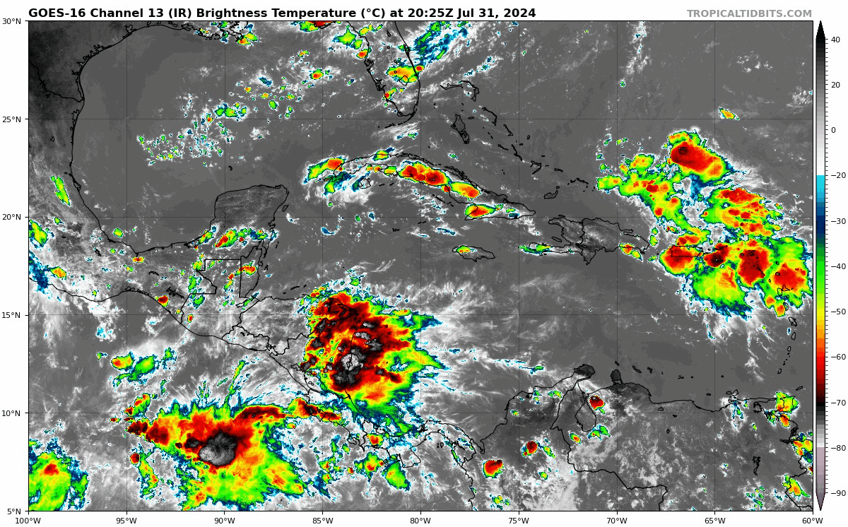
Keldeo1997 wrote:We will have a big problem if models start stalling it in the middle of the gulf and not inland. That raises the ceiling significantly


I don't think we should take the 18Z GFS literally.
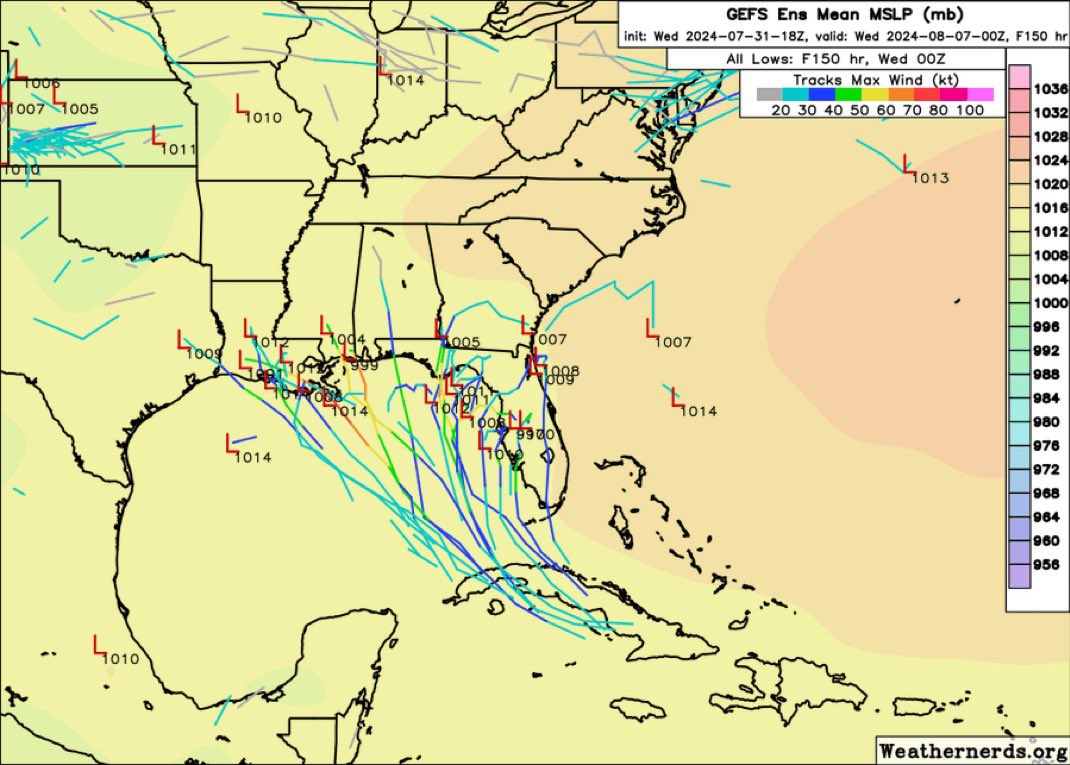
Stalls about 2 days over Tate's Hell State Forest due to the ridging.
The original track had a larger dip bypassing NOLA and driving north into the Louisiana coast further west.
And the UKM et, straight up from the Yucatan channel 1116 mile over bathtub warm gulf :roll:
0 likes   

IcyTundra
Category 5
Category 5
Posts: 1205
Joined: Mon Jun 07, 2021 9:32 pm
Location: Dickinson, Texas

Re: Possible development in the Western Atlantic (0/60)

#522 Postby IcyTundra » Wed Jul 31, 2024 5:42 pm

18Z GFS shows up to 40 inches of rain in areas up near the FL/GA border.
0 likes   

IcyTundra
Category 5
Category 5
Posts: 1205
Joined: Mon Jun 07, 2021 9:32 pm
Location: Dickinson, Texas

Re: Possible development in the Western Atlantic (0/60)

#523 Postby IcyTundra » Wed Jul 31, 2024 5:46 pm

18Z GEFS through 126 hours. Almost all members that show development are in the Gulf with a spread from Louisiana to the West Coast of Florida.

Image
0 likes   

Stratton23
Category 5
Category 5
Posts: 2515
Joined: Fri Jul 21, 2023 10:59 pm
Location: Katy, Tx

Re: Possible development in the Western Atlantic (0/60)

#524 Postby Stratton23 » Wed Jul 31, 2024 5:53 pm

18z GEFS with a big uptick, spread from tampa to LA/ TEX border, gonna be a wild week ahead of watching this one
0 likes   

User avatar
Blown Away
S2K Supporter
S2K Supporter
Posts: 10145
Joined: Wed May 26, 2004 6:17 am

Re: Possible development in the Western Atlantic (0/60)

#525 Postby Blown Away » Wed Jul 31, 2024 6:00 pm

Image

The 2pm position was just ESE of PR. Lots of deep convection well N of that location. JMHO, when we have a very undefined AOI and we see big swings in model tracks or weird stalls, sometimes the models were off on where the consolidation is really happening resulting in strange outcomes.
2 likes   
Hurricane Eye Experience: David 79, Irene 99, Frances 04, Jeanne 04, Wilma 05... EYE COMING MY WAY IN 2024…
Hurricane Brush Experience: Andrew 92, Erin 95, Floyd 99, Matthew 16, Irma 17, Ian 22, Nicole 22…

User avatar
Hypercane_Kyle
Category 5
Category 5
Posts: 3352
Joined: Sat Mar 07, 2015 7:58 pm
Location: Cape Canaveral, FL

Re: Possible development in the Western Atlantic (0/60)

#526 Postby Hypercane_Kyle » Wed Jul 31, 2024 6:01 pm

That stall scenario is definitely concerning. Most models are showing it now.
0 likes   
My posts are my own personal opinion, defer to the National Hurricane Center (NHC) and other NOAA products for decision making during hurricane season.

User avatar
toad strangler
S2K Supporter
S2K Supporter
Posts: 4543
Joined: Sun Jul 28, 2013 3:09 pm
Location: Earth
Contact:

Re: Possible development in the Western Atlantic (0/60)

#527 Postby toad strangler » Wed Jul 31, 2024 6:18 pm

2 likes   

hipshot
Category 2
Category 2
Posts: 591
Joined: Tue Jul 06, 2010 9:18 pm
Location: Dallas, Texas

Re: Possible development in the Western Atlantic (0/60)

#528 Postby hipshot » Wed Jul 31, 2024 6:25 pm

Blown Away wrote:https://i.postimg.cc/NGNxBVJ1/goes16-ir-watl.gif

The 2pm position was just ESE of PR. Lots of deep convection well N of that location. JMHO, when we have a very undefined AOI and we see big swings in model tracks or weird stalls, sometimes the models were off on where the consolidation is really happening resulting in strange outcomes.

What is that wicked looking convection over the Nicaragua area?
0 likes   

User avatar
cycloneye
Admin
Admin
Posts: 145277
Age: 68
Joined: Thu Oct 10, 2002 10:54 am
Location: San Juan, Puerto Rico

Re: Possible development in the Western Atlantic (0/60)

#529 Postby cycloneye » Wed Jul 31, 2024 6:32 pm

Cone more west in GOM.

Tropical Weather Outlook
NWS National Hurricane Center Miami FL
800 PM EDT Wed Jul 31 2024

For the North Atlantic...Caribbean Sea and the Gulf of Mexico:

Southwestern Atlantic and Eastern Gulf of Mexico:
A tropical wave is producing a large area of disorganized showers
and thunderstorms over Puerto Rico, the Virgin Islands, the Leeward
Islands, and the adjacent waters of the southwestern Atlantic and
northeastern Caribbean Sea. Development of this system is not
anticipated during the next few days while it moves
west-northwestward over portions of the Greater Antilles. However,
environmental conditions are forecast to be more conducive for
development after the wave passes the Greater Antilles, and a
tropical depression could form this weekend or early next week over
the eastern Gulf of Mexico or far southwestern Atlantic Ocean,
including in the vicinity of Florida. Interests across the Greater
Antilles, Bahamas, and Florida should continue to monitor the
progress of this system.
* Formation chance through 48 hours...low...near 0 percent.
* Formation chance through 7 days...medium...60 percent.

$$
Forecaster Berg


Image
2 likes   
Visit the Caribbean-Central America Weather Thread where you can find at first post web cams,radars
and observations from Caribbean basin members Click Here

User avatar
SFLcane
S2K Supporter
S2K Supporter
Posts: 10163
Age: 47
Joined: Sat Jun 05, 2010 1:44 pm
Location: Lake Worth Florida

Re: Possible development in the Western Atlantic (0/60)

#530 Postby SFLcane » Wed Jul 31, 2024 6:43 pm

Image
0 likes   

floridasun
Tropical Storm
Tropical Storm
Posts: 200
Joined: Tue Sep 14, 2021 3:59 pm

Re: Possible development in the Western Atlantic (0/60)

#531 Postby floridasun » Wed Jul 31, 2024 7:01 pm

i think that whole state will get a lot rain e4ven here in south fl because we on right side of low pressure let see were low form nhc likely make this invest by 11pm
0 likes   

User avatar
AtlanticWind
S2K Supporter
S2K Supporter
Posts: 1887
Age: 66
Joined: Sun Aug 08, 2004 9:57 pm
Location: Plantation,Fla

Re: Possible development in the Western Atlantic (0/60)

#532 Postby AtlanticWind » Wed Jul 31, 2024 7:04 pm

I wouldn’t sleep on this for S Florida yet as the models are still jumping around.
If a center gets North of Cuban coastline we could possibly get a quick spin up
on this system.
3 likes   

Stratton23
Category 5
Category 5
Posts: 2515
Joined: Fri Jul 21, 2023 10:59 pm
Location: Katy, Tx

Re: Possible development in the Western Atlantic (0/60)

#533 Postby Stratton23 » Wed Jul 31, 2024 7:07 pm

thats quite the spread on the GEFS lol
0 likes   

BobHarlem
Category 5
Category 5
Posts: 2100
Joined: Thu Oct 20, 2005 6:11 pm

Re: Possible development in the Western Atlantic (0/60)

#534 Postby BobHarlem » Wed Jul 31, 2024 7:08 pm

Stratton23 wrote:thats quite the spread on the GEFS lol

It gets even more silly a bit later in the run like a big splat up against the southeast. A few ensembles have it hanging around there until Friday/Saturday.

Image
Last edited by BobHarlem on Wed Jul 31, 2024 7:10 pm, edited 1 time in total.
1 likes   

floridasun
Tropical Storm
Tropical Storm
Posts: 200
Joined: Tue Sep 14, 2021 3:59 pm

Re: Possible development in the Western Atlantic (0/60)

#535 Postby floridasun » Wed Jul 31, 2024 7:09 pm

AtlanticWind wrote:I wouldn’t sleep on this for S Florida yet as the models are still jumping around.
If a center gets North of Cuban coastline we could possibly get a quick spin up
on this system.

i never take eye off system to my east we see if go all over islands or go north them a bit
1 likes   

User avatar
SFLcane
S2K Supporter
S2K Supporter
Posts: 10163
Age: 47
Joined: Sat Jun 05, 2010 1:44 pm
Location: Lake Worth Florida

Re: Possible development in the Western Atlantic (0/60)

#536 Postby SFLcane » Wed Jul 31, 2024 7:13 pm

0 likes   

User avatar
WaveBreaking
Category 2
Category 2
Posts: 578
Joined: Sun Jun 30, 2024 11:33 am
Location: US

Re: Possible development in the Western Atlantic (0/60)

#537 Postby WaveBreaking » Wed Jul 31, 2024 7:13 pm

Image
0 likes   
I am NOT a professional meteorologist, so take all of my posts with a grain of salt. My opinions are mine and mine alone.

User avatar
SFLcane
S2K Supporter
S2K Supporter
Posts: 10163
Age: 47
Joined: Sat Jun 05, 2010 1:44 pm
Location: Lake Worth Florida

Re: Possible development in the Western Atlantic (0/60)

#538 Postby SFLcane » Wed Jul 31, 2024 7:19 pm

Big blowup north of PR,…

Image
0 likes   

lsuhurricane
Category 1
Category 1
Posts: 251
Joined: Tue Aug 15, 2017 2:53 pm

Re: Possible development in the Western Atlantic (0/60)

#539 Postby lsuhurricane » Wed Jul 31, 2024 7:31 pm

End of 18z Euro appears to be a tad west of the 12z run. 90 hrs

Not intensifying at that point though
0 likes   

User avatar
ThunderForce
Tropical Storm
Tropical Storm
Posts: 208
Age: 25
Joined: Tue Sep 27, 2022 6:20 pm
Location: Calhoun County, Florida

Re: Possible development in the Western Atlantic (0/60)

#540 Postby ThunderForce » Wed Jul 31, 2024 7:39 pm

Huh? Are tropical waves really less likely to strengthen if they stall for a time? I haven't heard this before.
This is related to the current tropical wave that's being monitored in this thread.

 https://x.com/bryan_maxw46284/status/1818763674569289753

0 likes   
Please refer to the NWS, NHC, SPC or a professional meteorologist for information and decision making during storms.


Return to “Talkin' Tropics”

Who is online

Users browsing this forum: AnnularCane, Hypercane_Kyle and 34 guests