


And cat 2...

landfalls in the panhandle after this, but still is crawling, going for Alabama still raining, finally starts really moving again deeper inland about midday Friday.
Moderator: S2k Moderators

WaveBreaking wrote:One thing I recently noticed with this setup is that models were possibly overdoing the Fujiwhara interaction between the ITCZ disturbance and the AEW.
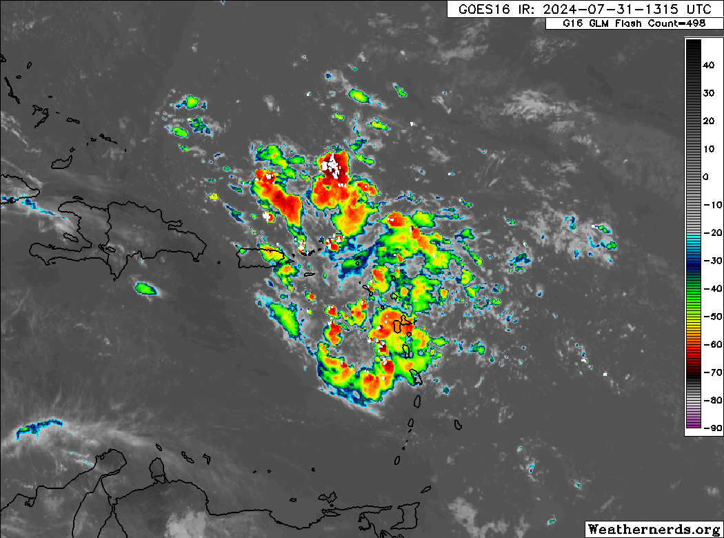
Current satellite imagery shows our main wave axis near the Leeward Islands, but the ITCZ disturbance is lagging behind and is elongated E to W.
https://i.imgur.com/kJ7YDbG.jpeg
My original understanding of what supposed to happen between the two vort maxes was that the ITCZ disturbance was supposed to pivot N of the wave, strengthen, and become the dominant feature as seen below:
https://i.imgur.com/aO1dych.gif
But what happened instead was that the ITCZ disturbance failed to pivot N into more favorable conditions and instead got sheared out by the wave, meaning that the wave was never pulled N.
https://i.imgur.com/GtbKYmb.jpeg
Therefore, one could make the conclusion that the more southern track solutions are more likely barring any downstream influence from a stronger-than-forecast trough.


AnnularCane wrote:I wish they'd make it an invest so it can have a floater. I keep going into Tropical Tidbits forgetting that there's no floater yet and have to settle for one of the wider views instead.


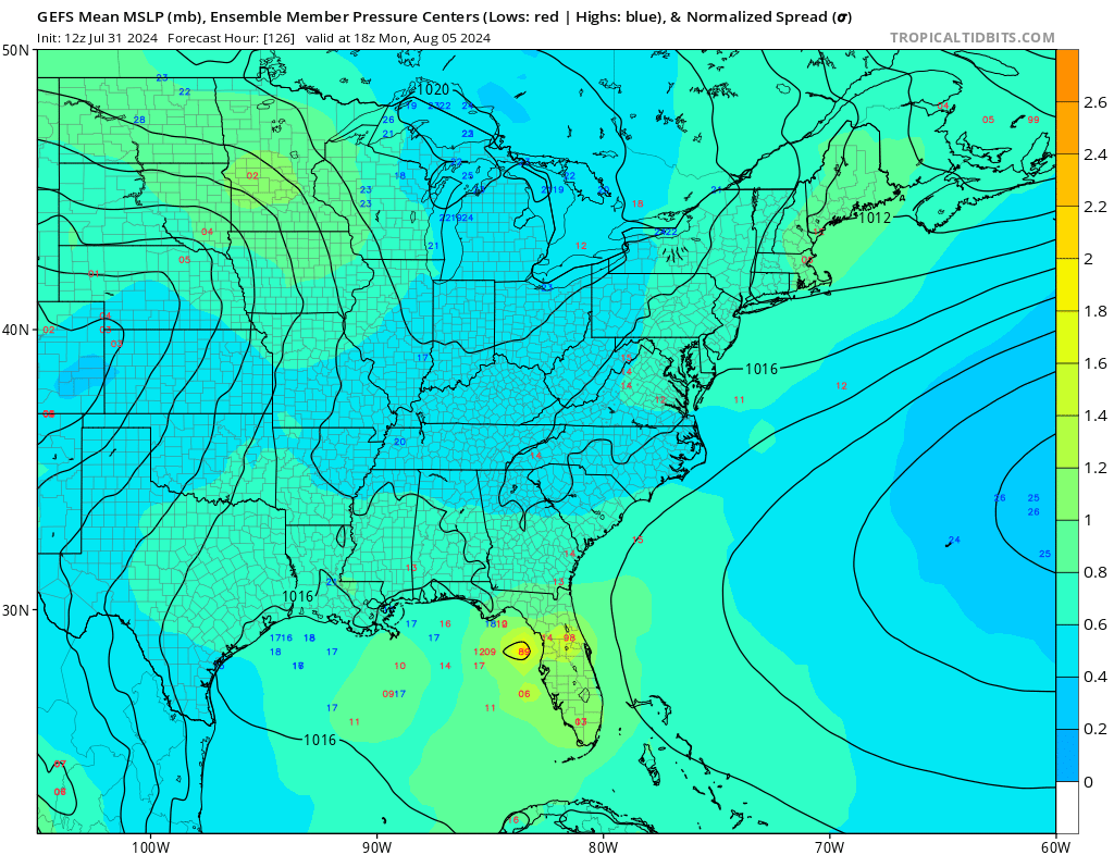
wxman57 wrote:GFS remains the only model that predicts a closed low center in the Gulf. It's 12z run looks quite odd. Let's hope something like that doesn't materialize. I'm still thinking east of Florida is more likely.
WaveBreaking wrote:One thing I recently noticed with this setup is that models were possibly overdoing the Fujiwhara interaction between the ITCZ disturbance and the AEW.
Current satellite imagery shows our main wave axis near the Leeward Islands, but the ITCZ disturbance is lagging behind and is elongated E to W.
https://i.imgur.com/kJ7YDbG.jpeg
My original understanding of what supposed to happen between the two vort maxes was that the ITCZ disturbance was supposed to pivot N of the wave, strengthen, and become the dominant feature as seen below:
https://i.imgur.com/aO1dych.gif
But what happened instead was that the ITCZ disturbance failed to pivot N into more favorable conditions and instead got sheared out by the wave, meaning that the wave was never pulled N.
https://i.imgur.com/GtbKYmb.jpeg
Therefore, one could make the conclusion that the more southern track solutions are more likely barring any downstream influence from a stronger-than-forecast trough.
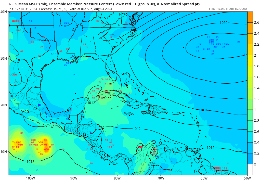
GCANE wrote:Looking at CIMSS
925 & 700mb vort are just east of PR
500mb vort is farther to the east,
GFS doesn't initialize it very well, showing wave-type structures.
The 500mb vort will likely make it thru the Antilles and enter the GoM NW of Cuba.
It would be very likely strong convection would drive the Mid-Level vort to the surface.
That's what Hot Towers are noted for.
This could lead to a significant TC in the GoM.
wxman57 wrote:GFS remains the only model that predicts a closed low center in the Gulf. It's 12z run looks quite odd. Let's hope something like that doesn't materialize. I'm still thinking east of Florida is more likely.
GCANE wrote:GCANE wrote:Looking at CIMSS
925 & 700mb vort are just east of PR
500mb vort is farther to the east,
GFS doesn't initialize it very well, showing wave-type structures.
The 500mb vort will likely make it thru the Antilles and enter the GoM NW of Cuba.
It would be very likely strong convection would drive the Mid-Level vort to the surface.
That's what Hot Towers are noted for.
This could lead to a significant TC in the GoM.
GFS has a strong anti-cyclone developing in the east GoM a day later when this mid-level vort exits Cuba
 Going forward from here, I would definitely say slower is bad/faster-better
SFLcane wrote:https://i.postimg.cc/T2kHr28m/bnbnb.gif
Users browsing this forum: No registered users and 184 guests


