Possible development in the Western Atlantic / GOM (Is Invest 97L)
Moderator: S2k Moderators
Forum rules

The posts in this forum are NOT official forecasts and should not be used as such. They are just the opinion of the poster and may or may not be backed by sound meteorological data. They are NOT endorsed by any professional institution or STORM2K. For official information, please refer to products from the National Hurricane Center and National Weather Service.
-
lsuhurricane
- Category 1

- Posts: 270
- Joined: Tue Aug 15, 2017 2:53 pm
Re: Possible development in the Western Atlantic (0/60)
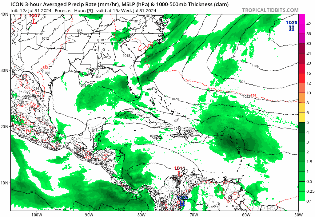
Appears that the ICON is keeping this in the GOM. Stronger ridging on the eastern seaboard being the culprit.
0 likes
-
AnnularCane

- S2K Supporter

- Posts: 2964
- Joined: Thu Jun 08, 2006 9:18 am
- Location: Wytheville, VA
Re: Possible development in the Western Atlantic (0/60)
toad strangler wrote:https://twitter.com/mjventrice/status/1818662816405913937?s=46
Not bad considering that that doesn't sound like the healthiest breakfast.
1 likes
"But it never rained rain. It never snowed snow. And it never blew just wind. It rained things like soup and juice. It snowed mashed potatoes and green peas. And sometimes the wind blew in storms of hamburgers." -- Judi Barrett, Cloudy with a Chance of Meatballs
Re: Possible development in the Western Atlantic (0/60)
12z Icon goes through keys/south Florida briefly pops into the Gulf, then exits via Jacksonville, and the newer part, now forms it into a hurricane offshore of NC.
1 likes
Re: Possible development in the Western Atlantic (0/60)
SFLcane wrote:https://i.postimg.cc/Kz22LGMB/bnbnb.gif
From that view, the split of the wave sure looks like it may be a real thing!
0 likes
-
Blown Away

- S2K Supporter
- Posts: 10253
- Joined: Wed May 26, 2004 6:17 am
Re: Possible development in the Western Atlantic (0/60)
BobHarlem wrote:12z Icon goes through keys/south Florida briefly pops into the Gulf, then exits via Jacksonville, and the newer part, now forms it into a hurricane offshore of NC.
12z ICON rakes over all the GA islands and then tries to consolidate in the FL Straits before going over the FL Peninsula... I wonder IF this area moves just N of the GA islands will the models see better conditions earlier?
2 likes
Hurricane Eye Experience: David 79, Irene 99, Frances 04, Jeanne 04, Wilma 05… Hurricane Brush Experience: Andrew 92, Erin 95, Floyd 99, Matthew 16, Irma 17, Ian 22, Nicole 22…
Re: Possible development in the Western Atlantic (0/60)
Notable Gulf/E. Coast split in the 6z Euro ensembles. Follows along with the weaker wave goes into the Gulf idea. (compared to 0z which had almost nothing in the Gulf)

Last edited by BobHarlem on Wed Jul 31, 2024 11:02 am, edited 1 time in total.
0 likes

Re: Possible development in the Western Atlantic (0/60)
If I were forced to project where an invest would be established, I'd guess close to 17.8 N & 62.8 W (stretched SSE to NNW)
0 likes
Andy D
(For official information, please refer to the NHC and NWS products.)
(For official information, please refer to the NHC and NWS products.)
Re: Possible development in the Western Atlantic (0/60)
12Z GFS and ICON looking pretty similar at 102 hr's (so far)
0 likes
Andy D
(For official information, please refer to the NHC and NWS products.)
(For official information, please refer to the NHC and NWS products.)
-
Blown Away
- S2K Supporter
- Posts: 10253
- Joined: Wed May 26, 2004 6:17 am
Re: Possible development in the Western Atlantic (0/60)

If this AOI moves rakes over all the GA Islands it will stay shallow, move farther W, and lift into the EGOM and develop (12z GFS).
If AOI lifts just N of the GA Islands I think it will find better conditions, deepen near Bahamas and be a threat to FL/SE CONUS... JMHO
0 likes
Hurricane Eye Experience: David 79, Irene 99, Frances 04, Jeanne 04, Wilma 05… Hurricane Brush Experience: Andrew 92, Erin 95, Floyd 99, Matthew 16, Irma 17, Ian 22, Nicole 22…
-
toad strangler

- S2K Supporter
- Posts: 4546
- Joined: Sun Jul 28, 2013 3:09 pm
- Location: Earth
- Contact:
Re: Possible development in the Western Atlantic (0/60)
12z GFS landfalls in the FL Big Bend. REALLY REALLY slow. Pretty much stalling
Last edited by toad strangler on Wed Jul 31, 2024 11:09 am, edited 1 time in total.
0 likes
My Weather Station
https://www.wunderground.com/dashboard/pws/KFLPORTS603
https://www.wunderground.com/dashboard/pws/KFLPORTS603
Re: Possible development in the Western Atlantic (0/60)
TD/TS landfall in Big Bend, moving pretty slow and more or less stalls on the Big Bend. Much of Florida would get inundated on this run.

0 likes
Re: Possible development in the Western Atlantic (0/60)
Hey Debby, I've got Elena on the line. She told me to tell you "Respect the Ridge" 
3 likes
Andy D
(For official information, please refer to the NHC and NWS products.)
(For official information, please refer to the NHC and NWS products.)
Re: Possible development in the Western Atlantic (0/60)
After stalling around the Big Bend for a day or so, it makes it back into the Gulf at hour 156

0 likes
-
WaveBreaking

- Category 2

- Posts: 728
- Joined: Sun Jun 30, 2024 11:33 am
- Location: US
Re: Possible development in the Western Atlantic (0/60)
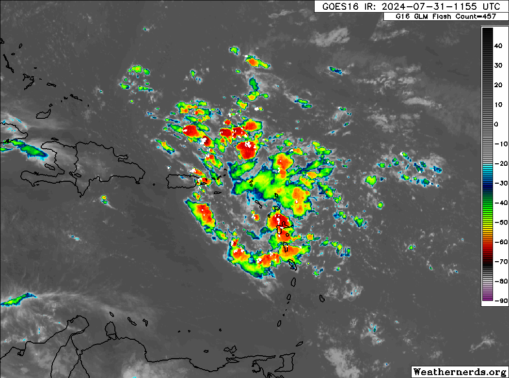
One thing I recently noticed with this setup is that models were possibly overdoing the Fujiwhara interaction between the ITCZ disturbance and the AEW.
Current satellite imagery shows our main wave axis near the Leeward Islands, but the ITCZ disturbance is lagging behind and is elongated E to W.

My original understanding of what supposed to happen between the two vort maxes was that the ITCZ disturbance was supposed to pivot N of the wave, strengthen, and become the dominant feature as seen below:

But what happened instead was that the ITCZ disturbance failed to pivot N into more favorable conditions and instead got sheared out by the wave, meaning that the wave was never pulled N.

Therefore, one could make the conclusion that the more southern track solutions are more likely barring any downstream influence from a stronger-than-forecast trough.
Current satellite imagery shows our main wave axis near the Leeward Islands, but the ITCZ disturbance is lagging behind and is elongated E to W.
My original understanding of what supposed to happen between the two vort maxes was that the ITCZ disturbance was supposed to pivot N of the wave, strengthen, and become the dominant feature as seen below:
But what happened instead was that the ITCZ disturbance failed to pivot N into more favorable conditions and instead got sheared out by the wave, meaning that the wave was never pulled N.
Therefore, one could make the conclusion that the more southern track solutions are more likely barring any downstream influence from a stronger-than-forecast trough.
4 likes
I am NOT a professional meteorologist, so take all of my posts with a grain of salt. My opinions are mine and mine alone.
-
toad strangler
- S2K Supporter
- Posts: 4546
- Joined: Sun Jul 28, 2013 3:09 pm
- Location: Earth
- Contact:
Re: Possible development in the Western Atlantic (0/60)
Geez this operational GFS 12z run would flood the entire FL peninsula if it verified. Another crazy run and it ain't over yet.
3 likes
My Weather Station
https://www.wunderground.com/dashboard/pws/KFLPORTS603
https://www.wunderground.com/dashboard/pws/KFLPORTS603
Re: Possible development in the Western Atlantic (0/60)
toad strangler wrote:Geez this operational GFS 12z run would flood the entire FL peninsula if it verified. Another crazy run and it ain't over yet.
Why not?


Last edited by BobHarlem on Wed Jul 31, 2024 11:19 am, edited 1 time in total.
0 likes
Re: Possible development in the Western Atlantic (0/60)
toad strangler wrote:Geez this operational GFS 12z run would flood the entire FL peninsula if it verified. Another crazy run and it ain't over yet.
That AIFS model run seemed crazy..... but maybe not SO crazy LOL
0 likes
Andy D
(For official information, please refer to the NHC and NWS products.)
(For official information, please refer to the NHC and NWS products.)
-
Stratton23
- Category 5

- Posts: 3578
- Joined: Fri Jul 21, 2023 10:59 pm
- Location: Katy, Tx
Re: Possible development in the Western Atlantic (0/60)
Thats an almost harvey like stall on the GFS, its going to get very tricky when it gets into the gulf with potentially a ridge trapping it in place or causing it to move very sporadically
0 likes
-
toad strangler
- S2K Supporter
- Posts: 4546
- Joined: Sun Jul 28, 2013 3:09 pm
- Location: Earth
- Contact:
Re: Possible development in the Western Atlantic (0/60)
chaser1 wrote:toad strangler wrote:Geez this operational GFS 12z run would flood the entire FL peninsula if it verified. Another crazy run and it ain't over yet.
That AIFS model run seemed crazy..... but maybe not SO crazy LOL
That's almost 4 straight days of stalling / meandering
0 likes
My Weather Station
https://www.wunderground.com/dashboard/pws/KFLPORTS603
https://www.wunderground.com/dashboard/pws/KFLPORTS603
-
SFLcane

- S2K Supporter
- Posts: 10281
- Age: 48
- Joined: Sat Jun 05, 2010 1:44 pm
- Location: Lake Worth Florida
Re: Possible development in the Western Atlantic (0/60)
toad strangler wrote:Geez this operational GFS 12z run would flood the entire FL peninsula if it verified. Another crazy run and it ain't over yet.
My point indeed! Impacts are coming to the peninsula to what extent not sure yet. Even a weak storm brings impacts ask texas how it went with there cat 1.
0 likes
Who is online
Users browsing this forum: Kingarabian, Ulf and 159 guests