ATL: BERYL - Models
Moderator: S2k Moderators

Re: ATL: BERYL - Models
GFS finally got a bit more serious about the intensity of the storm, and then doubled down on the westward bend, and the whole destroyed in the bay of campeche deal. What the heck...
0 likes
Re: ATL: BERYL - Models
ROCK wrote:12Z JMA hooks it right into Freeport. Just for fun...
Not because it is a good model (it isn’t at all), but for the record just in case the highly unlikely landfall at the upper TX coast were to occur:
these 12Z JMA runs landfall at the upper TX coast: 6/30, 7/2, 7/3, 7/4…so 4 of the last 5 12Z JMA runs
0 likes
Personal Forecast Disclaimer:
The posts in this forum are NOT official forecasts and should not be used as such. They are just the opinion of the poster and may or may not be backed by sound meteorological data. They are NOT endorsed by any professional institution or storm2k.org. For official information, please refer to the NHC and NWS products.
The posts in this forum are NOT official forecasts and should not be used as such. They are just the opinion of the poster and may or may not be backed by sound meteorological data. They are NOT endorsed by any professional institution or storm2k.org. For official information, please refer to the NHC and NWS products.
-
LadyBug72

- Tropical Storm

- Posts: 121
- Joined: Mon Jun 01, 2020 3:39 pm
- Location: about 20 miles from Galveston, Tx
Re: ATL: BERYL - Models
Did the 18Z Icon move down by Brownsville?
0 likes
Formerly known as the user: Nikki
Alicia 83, Allison 01, Rita 05, Ike 08, Harvey 17, Nicholas 21, Coastal Texas Derecho 24, Beryl 24
Alicia 83, Allison 01, Rita 05, Ike 08, Harvey 17, Nicholas 21, Coastal Texas Derecho 24, Beryl 24

Re: ATL: BERYL - Models
LadyBug72 wrote:Did the 18Z Icon move down by Brownsville?
no more mid coast...not yet any way..lol
0 likes
-
LadyBug72
- Tropical Storm
- Posts: 121
- Joined: Mon Jun 01, 2020 3:39 pm
- Location: about 20 miles from Galveston, Tx
Re: ATL: BERYL - Models
ROCK wrote:LadyBug72 wrote:Did the 18Z Icon move down by Brownsville?
no more mid coast...not yet any way..lol
LOL! Thanks! I don’t really follow the ICON but I did get a message that it moved down by Brownsville so I was curious.
0 likes
Formerly known as the user: Nikki
Alicia 83, Allison 01, Rita 05, Ike 08, Harvey 17, Nicholas 21, Coastal Texas Derecho 24, Beryl 24
Alicia 83, Allison 01, Rita 05, Ike 08, Harvey 17, Nicholas 21, Coastal Texas Derecho 24, Beryl 24
Re: ATL: BERYL - Models
LarryWx wrote:ROCK wrote:12Z JMA hooks it right into Freeport. Just for fun...
Not because it is a good model (it isn’t at all), but for the record just in case the highly unlikely landfall at the upper TX coast were to occur:
these 12Z JMA runs landfall at the upper TX coast: 6/30, 7/2, 7/3, 7/4…so 4 of the last 5 12Z JMA runs
lol...interesting to see the NHC spread on Sunday night.....that cone is more than half of the TX coastline up to Surfside almost...tells me they are hedging their bet a little. lol .....JMO of course
2 likes
Re: ATL: BERYL - Models
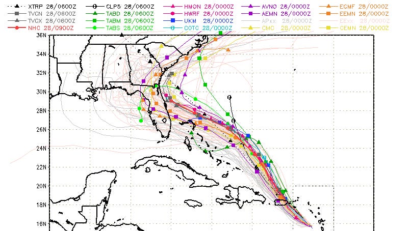
Been trying to search for a few days to see what happened to the classic SFWMD model display graphic product. I realize there are better looking ones, but I tended to prefer it anyway, if only for the XTRP and CLP5 entertainment value.
Anyone know what happened?
Old link:
https://www.sfwmd.gov/weather-radar/hur ... odel-plots
Example image:
Anyone know what happened?
Old link:
https://www.sfwmd.gov/weather-radar/hur ... odel-plots
Example image:
1 likes
Baton Rouge area cyclone dilettante, PSWAGGER* tropical weather & hydrology model developer
(* Pseudo-Scientific Wild-A** Guesses Generally Expressed Ridiculously)
The GFDL would've had all this figured out by now.
(* Pseudo-Scientific Wild-A** Guesses Generally Expressed Ridiculously)
The GFDL would've had all this figured out by now.
-
ColdFusion

- S2K Supporter

- Posts: 452
- Joined: Wed Feb 13, 2008 3:46 pm
- Location: Addison, TX
Re: ATL: BERYL - Models
ROCK wrote:LarryWx wrote:ROCK wrote:12Z JMA hooks it right into Freeport. Just for fun...
Not because it is a good model (it isn’t at all), but for the record just in case the highly unlikely landfall at the upper TX coast were to occur:
these 12Z JMA runs landfall at the upper TX coast: 6/30, 7/2, 7/3, 7/4…so 4 of the last 5 12Z JMA runs
lol...interesting to see the NHC spread on Sunday night.....that cone is more than half of the TX coastline up to Surfside almost...tells me they are hedging their bet a little. lol .....JMO of course
The spread of the hurricane cone remains consistent and does not vary.
1 likes
Re: ATL: BERYL - Models
0 likes
Personal Forecast Disclaimer:
The posts in this forum are NOT official forecast and should not be used as such. They are just the opinion of the poster and may or may not be backed by sound meteorological data. They are NOT endorsed by any professional institution or storm2k.org. For official information, please refer to the NHC and NWS products.
The posts in this forum are NOT official forecast and should not be used as such. They are just the opinion of the poster and may or may not be backed by sound meteorological data. They are NOT endorsed by any professional institution or storm2k.org. For official information, please refer to the NHC and NWS products.
Re: ATL: BERYL - Models
18Z HMON keeps it pretty weak across the GOM. Never recovers from the Yuc. looks about MX/ TX...
Edit: squeezes in around Brownsville and proceeds to run up the coast line at 84hr
Edit: squeezes in around Brownsville and proceeds to run up the coast line at 84hr
Last edited by ROCK on Thu Jul 04, 2024 6:35 pm, edited 1 time in total.
0 likes
-
Stratton23
- Category 5

- Posts: 3580
- Joined: Fri Jul 21, 2023 10:59 pm
- Location: Katy, Tx
Re: ATL: BERYL - Models
Blinhart wrote:https://www.tropicaltidbits.com/storminfo/02L_tracks_latest.png
Brownsville, TX could get a direct hit or at least be on the very bad side. I dont think this is a case of being in the path 3 days out means you wont get hit.
0 likes
-
Stratton23
- Category 5
- Posts: 3580
- Joined: Fri Jul 21, 2023 10:59 pm
- Location: Katy, Tx
Re: ATL: BERYL - Models
The HWRF is likely the closest to whats going to happen, im just not buying the ofher hurricane models weakening this down to a cat 1 at landfall, HWRF has a cat 3 at landfall near cozumal, i think thats more of a likely scenario as the hurricane is definitely improving in organization, shear is going down
1 likes
-
South Texas Storms

- Professional-Met

- Posts: 4261
- Joined: Thu Jun 24, 2010 12:28 am
- Location: Houston, TX
Re: ATL: BERYL - Models
18z Euro looks reasonable. Shifted a bit north from the 12z run. Shows a strengthening hurricane making a final landfall just south of Brownsville early Monday morning. 973 mb at landfall.
0 likes
Re: ATL: BERYL - Models
18Z GFS kills it way south into MX...keeps it weak after Yuc. probably why..
0 likes
-
Stratton23
- Category 5
- Posts: 3580
- Joined: Fri Jul 21, 2023 10:59 pm
- Location: Katy, Tx
Re: ATL: BERYL - Models
It eventually should get pulled north into texas due to the trough, i dont expect a due west motion once its inland
0 likes
-
cycloneye

- Admin

- Posts: 149750
- Age: 69
- Joined: Thu Oct 10, 2002 10:54 am
- Location: San Juan, Puerto Rico
Re: ATL: BERYL - Models
South Texas Storms wrote:18z Euro looks reasonable. Shifted a bit north from the 12z run. Shows a strengthening hurricane making a final landfall just south of Brownsville early Monday morning. 973 mb at landfall.
That is the strongest run yet from Euro for the landfall in NE Mexico, close to Brownsville.
0 likes
Visit the Caribbean-Central America Weather Thread where you can find at first post web cams,radars
and observations from Caribbean basin members Click Here
and observations from Caribbean basin members Click Here
-
starsfan65

- Category 2

- Posts: 738
- Age: 48
- Joined: Thu Dec 17, 2015 1:18 pm
- Location: Garland,Tx
Re: ATL: BERYL - Models
Stratton23 wrote:It eventually should get pulled north into texas due to the trough, i dont expect a due west motion once its inland
I don't buy the west movement.
0 likes
-
LadyBug72
- Tropical Storm
- Posts: 121
- Joined: Mon Jun 01, 2020 3:39 pm
- Location: about 20 miles from Galveston, Tx
Re: ATL: BERYL - Models
starsfan65 wrote:Stratton23 wrote:It eventually should get pulled north into texas due to the trough, i dont expect a due west motion once its inland
I don't buy the west movement.
The pro Mets are saying it’s moving west right now.
0 likes
Formerly known as the user: Nikki
Alicia 83, Allison 01, Rita 05, Ike 08, Harvey 17, Nicholas 21, Coastal Texas Derecho 24, Beryl 24
Alicia 83, Allison 01, Rita 05, Ike 08, Harvey 17, Nicholas 21, Coastal Texas Derecho 24, Beryl 24
-
Stratton23
- Category 5
- Posts: 3580
- Joined: Fri Jul 21, 2023 10:59 pm
- Location: Katy, Tx
Re: ATL: BERYL - Models
Im more so talking about the west movement once it gets inland near texas, it should get pulled N- NW into texas, could be a significant rain event out of this for the state somewhere
1 likes
Who is online
Users browsing this forum: No registered users and 34 guests