2024 Global Model Runs Discussion (Out thru day 16)

This is the general tropical discussion area. Anyone can take their shot at predicting a storms path.

Moderator: S2k Moderators

Forum rules

The posts in this forum are NOT official forecasts and should not be used as such. They are just the opinion of the poster and may or may not be backed by sound meteorological data. They are NOT endorsed by any professional institution or STORM2K. For official information, please refer to products from the National Hurricane Center and National Weather Service.

Help Support Storm2K
Message
Author
User avatar
Kohlecane
Category 2
Category 2
Posts: 593
Age: 33
Joined: Sun Jul 31, 2011 11:03 pm
Location: Beaufort, SC

Re: 2024 Global Model Runs Discussion (Out thru day 16)

#341 Postby Kohlecane » Thu Jun 13, 2024 11:03 pm

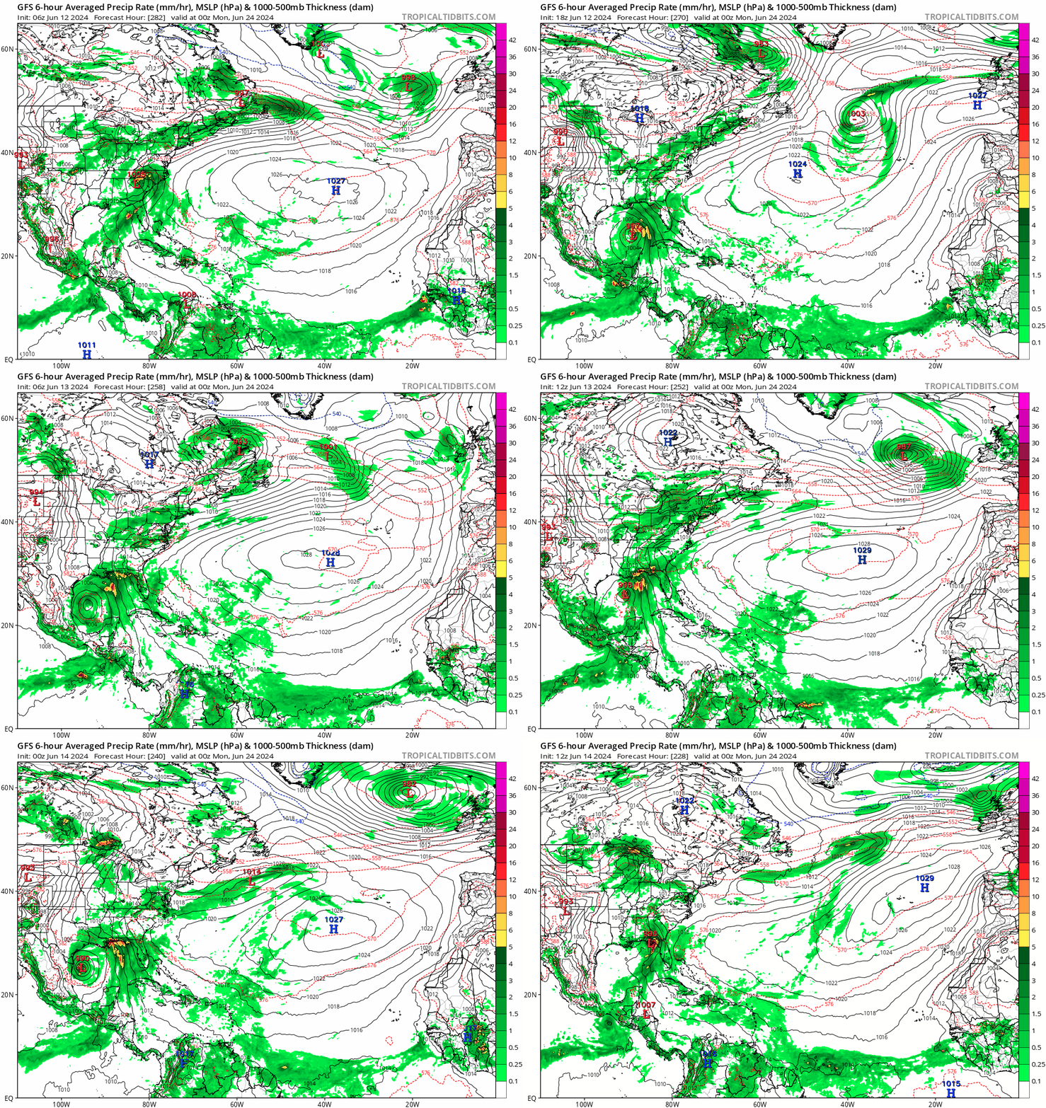
Stratton23 wrote:Holy mother of 18z model runs, that GFS is a nightmare, harvey 2.0, thankfully its long range so it wont verify, but still i get chills just looking at that run

Glad it's pretty far out, otherwise that's easily over a foot of rain in some coastal areas along TX, almost non stop for CC for almost a week. Also interesting feature that pops up along the LA Coast and aids to that moister. Tropical flooding and some Severe wx potential with that set up from Brownsville to Pensacola.
0 likes   
Once I see the REDS and GREENS Converge on a Base Velocity. ... I'm There!!

This is NOT an Official Forecast....Just my Opinion. For official information, please refer to the NHC and NWS products.
HIGHLIGHTS : '13 El Reno Tornado : 2013 Storm Chaser Tour, Joaquin; SC flood event, Matthew '16, Lowcountry Snow storm Jan '18

Stratton23
Category 5
Category 5
Posts: 2519
Joined: Fri Jul 21, 2023 10:59 pm
Location: Katy, Tx

Re: 2024 Global Model Runs Discussion (Out thru day 16)

#342 Postby Stratton23 » Thu Jun 13, 2024 11:58 pm

That 2nd system will need to be watched very closely, im becoming a little more concerned/ intrigued about the 500 mb height pattern showing in the models, CMC and GFS both show the system approaching south texas, here is what concerns me though, im seeing alot of ridging over the US in those models and no sort of shortwave or trough coming down, a system could potentially get trapped and stall as it approaches the western gulf coast, just my two cents but thats now a couple of runs in a row now the GFS ( ignoring intensity) has shown a stall , CMC showing signs of that as well
0 likes   

User avatar
skyline385
Category 5
Category 5
Posts: 2728
Age: 35
Joined: Wed Aug 26, 2020 11:15 pm
Location: Houston TX

Re: 2024 Global Model Runs Discussion (Out thru day 16)

#343 Postby skyline385 » Fri Jun 14, 2024 12:23 am

Stratton23 wrote:That 2nd system will need to be watched very closely, im becoming a little more concerned/ intrigued about the 500 mb height pattern showing in the models, CMC and GFS both show the system approaching south texas, here is what concerns me though, im seeing alot of ridging over the US in those models and no sort of shortwave or trough coming down, a system could potentially get trapped and stall as it approaches the western gulf coast, just my two cents but thats now a couple of runs in a row now the GFS ( ignoring intensity) has shown a stall , CMC showing signs of that as well


I would not worry about that system until we are within a week and it starts showing up on the other models like the GFS is showing. It literally does this every single year during June. Note how the Euro had it only for a run with a completely different and realistic genesis in the GoM compared to what the GFS is doing only to drop it. CMC has it forming similar to Euro but CMC has been performing poorly for a while now and even then its barely a system on it.
1 likes   

User avatar
Woofde
Category 1
Category 1
Posts: 479
Joined: Tue Jul 06, 2021 11:33 am

Re: RE: Re: 2024 Global Model Runs Discussion (Out thru day 16)

#344 Postby Woofde » Fri Jun 14, 2024 12:25 am

Stratton23 wrote:That 2nd system will need to be watched very closely, im becoming a little more concerned/ intrigued about the 500 mb height pattern showing in the models, CMC and GFS both show the system approaching south texas, here is what concerns me though, im seeing alot of ridging over the US in those models and no sort of shortwave or trough coming down, a system could potentially get trapped and stall as it approaches the western gulf coast, just my two cents but thats now a couple of runs in a row now the GFS ( ignoring intensity) has shown a stall , CMC showing signs of that as well
Yeah, this run and quite a few of the others show this potential system just crawling. This run it takes 7 days from when it forms in the WCar to when it finally landfalls on Texas.

There's potential, but we are still over 5 days out from formation, very possible nothing comes of it. I will say if this system actually forms, then this will be a major win for the GFS. It has been consistently showing the signal for a while now.Image
0 likes   

Stratton23
Category 5
Category 5
Posts: 2519
Joined: Fri Jul 21, 2023 10:59 pm
Location: Katy, Tx

Re: 2024 Global Model Runs Discussion (Out thru day 16)

#345 Postby Stratton23 » Fri Jun 14, 2024 12:28 am

Oh yeah intensity wise ill never trust the GFS there, im just a little interested in the 500 mb height pattern showing, nothing but ridging, no shortwave or trough coming down into the US, steering currents look weak on the gfs and cmc
0 likes   

User avatar
skyline385
Category 5
Category 5
Posts: 2728
Age: 35
Joined: Wed Aug 26, 2020 11:15 pm
Location: Houston TX

Re: 2024 Global Model Runs Discussion (Out thru day 16)

#346 Postby skyline385 » Fri Jun 14, 2024 12:50 am

Stratton23 wrote:Oh yeah intensity wise ill never trust the GFS there, im just a little interested in the 500 mb height pattern showing, nothing but ridging, no shortwave or trough coming down into the US, steering currents look weak on the gfs and cmc


Models can barely get the steering right 4-5 days out, let alone 10+ days out so I would not focus on the steering this far out. Weak steering causing stalls is particularly difficult to forecast and most models struggle at it this far out. If you look at the GEFS for the system, its spread across the entire Gulf coast meaning some ensemble members had a weakness or trough in the ridging pulling the system out.
3 likes   

ChrisH-UK
Category 2
Category 2
Posts: 625
Joined: Sat May 29, 2021 8:22 am

Re: 2024 Global Model Runs Discussion (Out thru day 16)

#347 Postby ChrisH-UK » Fri Jun 14, 2024 3:52 am

Personally I hope this model run does not happen. Now I would take note of this something will happen on the gulf coast that could be a hurricane that looks to rapidly form up with the heat, moisture and low shear that is predicted in the models it's looking to be a good setup for it too happened,

Image
1 likes   

Dean4Storms
S2K Supporter
S2K Supporter
Posts: 6358
Age: 62
Joined: Sun Aug 31, 2003 1:01 pm
Location: Miramar Bch. FL

Re: 2024 Global Model Runs Discussion (Out thru day 16)

#348 Postby Dean4Storms » Fri Jun 14, 2024 5:49 am

I would not get worked up over any of these GFS runs out beyond 5 days as far as TC formation and where it goes. There’s potential there but nothing for sure.
3 likes   

hurricane2025
Tropical Storm
Tropical Storm
Posts: 208
Joined: Thu Apr 08, 2021 10:36 am

Re: 2024 Global Model Runs Discussion (Out thru day 16)

#349 Postby hurricane2025 » Fri Jun 14, 2024 7:20 am

Don’t trust any models 6 plus days out
1 likes   

User avatar
wxman57
Moderator-Pro Met
Moderator-Pro Met
Posts: 22978
Age: 67
Joined: Sat Jun 21, 2003 8:06 pm
Location: Houston, TX (southwest)

Re: 2024 Global Model Runs Discussion (Out thru day 16)

#350 Postby wxman57 » Fri Jun 14, 2024 7:31 am

The GFS does this kind of thing in every basin. We have a client in the Bay of Bengal that uses the Windy app and generally asks us when we're starting advisories on a big cyclone that will pass near them in 10-12 days.

On another note, I came across a pretty good satellite website yesterday. Imagery looks like 1km resolution, but it allows direct measurements on screen and cursor lat/lon location.

https://zoom.earth/maps/satellite/
8 likes   

Tailgater33
Tropical Depression
Tropical Depression
Posts: 87
Joined: Thu Jun 02, 2022 9:15 am

Re: 2024 Global Model Runs Discussion (Out thru day 16)

#351 Postby Tailgater33 » Fri Jun 14, 2024 10:25 am

Very nice App. It’ll be interesting to see how accurate the pressure, winds and dew points are real time.
0 likes   

User avatar
TheAustinMan
Category 5
Category 5
Posts: 1047
Age: 25
Joined: Mon Jul 08, 2013 4:26 pm
Location: United States
Contact:

Re: 2024 Global Model Runs Discussion (Out thru day 16)

#352 Postby TheAustinMan » Fri Jun 14, 2024 10:39 am

The story of 90L and the front that it's entangled with may not be over... at least just yet. 90L or whatever remains of it will likely be elongating and reaching Newfoundland this weekend. The front that it's tied with will continue to gradually move out over the central Atlantic, but ridging will rapidly become established in its wake over the northeastern United States next week in part due to the tremendous amount of heat that's expected to be unleashed in the upper-troposphere by thunderstorms associated with the Central American Gyre. While the main headliner with that ridge is the heat wave that's expected to impact much of the Eastern US, the secondary effect is that this ridge might pull straggling parts of the front back west. It's a bit of a the "ridge over troubled water" scenario, only the subtropical waters at 33N aren't that troubled this time of year.

But, there is an outside shot that something could develop from the vorticity that gets siphoned from the front by the ridge. The odds of this happening are higher the farther south vorticity coalesces, as sea surface temperatures are closer to 26C near 30N and drop quickly to 23C near 35N east of Bermuda. There is some weak model support for such a system developing, such as on the GFS and the ECWMF, though in all likelihood whatever does form - if it does - will likely be weak given the marginal waters and a lack of the usual upper-air troughing that storms in the subtropics tend to rely on this early in the hurricane season.

Source: TropicalTidbits
Image
6 likes   
ImageImageImage
Treat my opinions with a grain of salt. For official information see your local weather service.

User avatar
skyline385
Category 5
Category 5
Posts: 2728
Age: 35
Joined: Wed Aug 26, 2020 11:15 pm
Location: Houston TX

Re: 2024 Global Model Runs Discussion (Out thru day 16)

#353 Postby skyline385 » Fri Jun 14, 2024 12:34 pm

skyline385 wrote:
Stratton23 wrote:Oh yeah intensity wise ill never trust the GFS there, im just a little interested in the 500 mb height pattern showing, nothing but ridging, no shortwave or trough coming down into the US, steering currents look weak on the gfs and cmc


Models can barely get the steering right 4-5 days out, let alone 10+ days out so I would not focus on the steering this far out. Weak steering causing stalls is particularly difficult to forecast and most models struggle at it this far out. If you look at the GEFS for the system, its spread across the entire Gulf coast meaning some ensemble members had a weakness or trough in the ridging pulling the system out.


As I said previously, just GFS being GFS and why you shouldn't worry about steering currents in medium to long range. We went from a stall near Mexico or south Texas to the Florida panhandle in a day.

Image
1 likes   

jlauderdal
S2K Supporter
S2K Supporter
Posts: 7182
Joined: Wed May 19, 2004 5:46 am
Location: NE Fort Lauderdale
Contact:

Re: 2024 Global Model Runs Discussion (Out thru day 16)

#354 Postby jlauderdal » Sat Jun 15, 2024 7:39 am

Cmon gang, you are sleeping on the models. The euro has a feature in a very dangerous location with the death ridge placement.

 https://x.com/BigJoeBastardi/status/1801954030874185790

0 likes   

User avatar
DorkyMcDorkface
Category 3
Category 3
Posts: 888
Age: 27
Joined: Mon Sep 30, 2019 1:32 pm
Location: Mid-Atlantic

Re: 2024 Global Model Runs Discussion (Out thru day 16)

#355 Postby DorkyMcDorkface » Sat Jun 15, 2024 8:36 am

TheAustinMan wrote:The story of 90L and the front that it's entangled with may not be over... at least just yet. 90L or whatever remains of it will likely be elongating and reaching Newfoundland this weekend. The front that it's tied with will continue to gradually move out over the central Atlantic, but ridging will rapidly become established in its wake over the northeastern United States next week in part due to the tremendous amount of heat that's expected to be unleashed in the upper-troposphere by thunderstorms associated with the Central American Gyre. While the main headliner with that ridge is the heat wave that's expected to impact much of the Eastern US, the secondary effect is that this ridge might pull straggling parts of the front back west. It's a bit of a the "ridge over troubled water" scenario, only the subtropical waters at 33N aren't that troubled this time of year.

But, there is an outside shot that something could develop from the vorticity that gets siphoned from the front by the ridge. The odds of this happening are higher the farther south vorticity coalesces, as sea surface temperatures are closer to 26C near 30N and drop quickly to 23C near 35N east of Bermuda. There is some weak model support for such a system developing, such as on the GFS and the ECWMF, though in all likelihood whatever does form - if it does - will likely be weak given the marginal waters and a lack of the usual upper-air troughing that storms in the subtropics tend to rely on this early in the hurricane season.

Source: TropicalTidbits
https://i.imgur.com/RvARkdg.gif

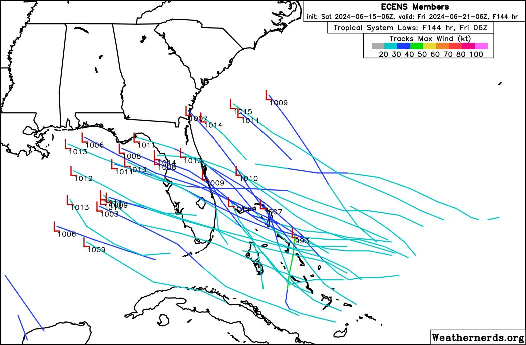
I think you're on to something...today's 06z Euro/EPS
Image
Image
1 likes   
Please note the thougths expressed by this account are solely those of the user and are from a hobbyist perspective. For more comprehensive analysis, consult an actual professional meteorologist or meteorology agency.


Floyd 1999 | Isabel 2003 | Hanna 2008 | Irene 2011 | Sandy 2012 | Isaias 2020

User avatar
NDG
S2K Supporter
S2K Supporter
Posts: 15446
Joined: Sun Jul 09, 2006 10:14 pm
Location: Orlando, FL

Re: 2024 Global Model Runs Discussion (Out thru day 16)

#356 Postby NDG » Sat Jun 15, 2024 10:59 am

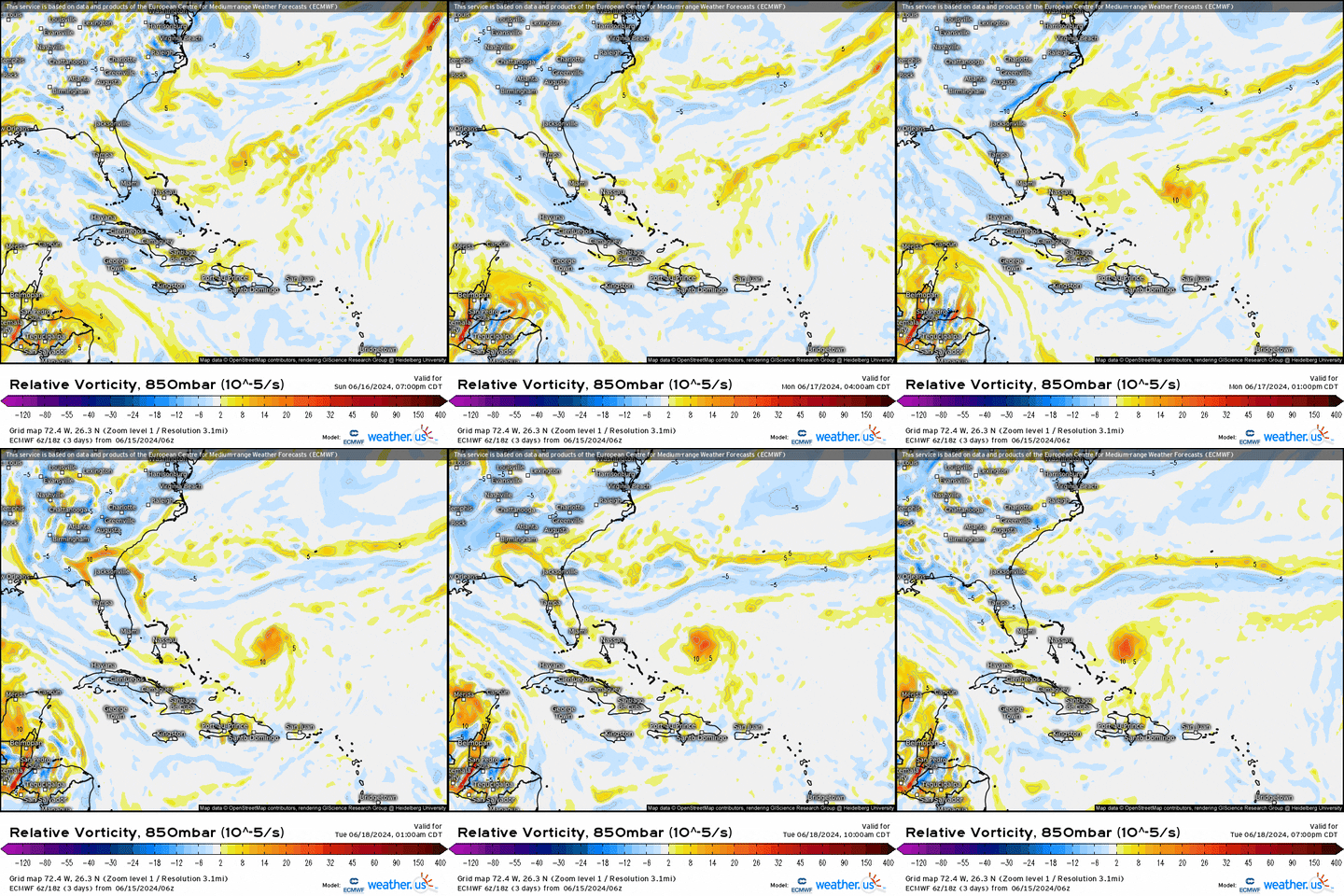
Will be interesting to see if the 12z Euro continues its solution of development near Bahamas and track west towards the FL/SE US. But it looks to have a hybrid subtropical look to it with it being so close to the ULL tracking west, possibly acquiring full tropical characteristics before coming inland, *if this comes to fruition.
Definitely has my attention.

Image
0 likes   

User avatar
Woofde
Category 1
Category 1
Posts: 479
Joined: Tue Jul 06, 2021 11:33 am

Re: RE: Re: 2024 Global Model Runs Discussion (Out thru day 16)

#357 Postby Woofde » Sat Jun 15, 2024 11:06 am

NDG wrote:Will be interesting to see if the 12z Euro continues its solution of development near Bahamas and track west towards the FL/SE US. But it looks to have a hybrid subtropical look to it with it being so close to the ULL tracking west, possibly acquiring full tropical characteristics before coming inland, *if this comes to fruition.
Definitely has my attention.

Image
The GFS just "spotted" in it's most recent run as well.Image
1 likes   

jlauderdal
S2K Supporter
S2K Supporter
Posts: 7182
Joined: Wed May 19, 2004 5:46 am
Location: NE Fort Lauderdale
Contact:

Re: RE: Re: 2024 Global Model Runs Discussion (Out thru day 16)

#358 Postby jlauderdal » Sat Jun 15, 2024 11:07 am

NDG wrote:Will be interesting to see if the 12z Euro continues its solution of development near Bahamas and track west towards the FL/SE US. But it looks to have a hybrid subtropical look to it with it being so close to the ULL tracking west, possibly acquiring full tropical characteristics before coming inland, *if this comes to fruition.
Definitely has my attention.

Image
Gfs is interested, weaker ridge but that will be sorted out later.
0 likes   

User avatar
NDG
S2K Supporter
S2K Supporter
Posts: 15446
Joined: Sun Jul 09, 2006 10:14 pm
Location: Orlando, FL

Re: RE: Re: 2024 Global Model Runs Discussion (Out thru day 16)

#359 Postby NDG » Sat Jun 15, 2024 11:28 am

jlauderdal wrote:
NDG wrote:Will be interesting to see if the 12z Euro continues its solution of development near Bahamas and track west towards the FL/SE US. But it looks to have a hybrid subtropical look to it with it being so close to the ULL tracking west, possibly acquiring full tropical characteristics before coming inland, *if this comes to fruition.
Definitely has my attention.

https://media.giphy.com/media/v1.Y2lkPTc5MGI3NjExcjFkZmt6a2ZrdWc5b3hjZXhuNjBvMnF3dW44ZWt6cXp1cXlpeWhzYSZlcD12MV9pbnRlcm5hbF9naWZfYnlfaWQmY3Q9Zw/Scsd4rAu5tU3XyI9M0/giphy.gif
Gfs is interested, weaker ridge but that will be sorted out later.


Actually thats a very strong ridge over the NE US thus a track west towards FL/SE US as it shows.

Image
0 likes   

User avatar
NDG
S2K Supporter
S2K Supporter
Posts: 15446
Joined: Sun Jul 09, 2006 10:14 pm
Location: Orlando, FL

Re: RE: Re: 2024 Global Model Runs Discussion (Out thru day 16)

#360 Postby NDG » Sat Jun 15, 2024 11:31 am

Woofde wrote:
NDG wrote:Will be interesting to see if the 12z Euro continues its solution of development near Bahamas and track west towards the FL/SE US. But it looks to have a hybrid subtropical look to it with it being so close to the ULL tracking west, possibly acquiring full tropical characteristics before coming inland, *if this comes to fruition.
Definitely has my attention.

https://media.giphy.com/media/v1.Y2lkPTc5MGI3NjExcjFkZmt6a2ZrdWc5b3hjZXhuNjBvMnF3dW44ZWt6cXp1cXlpeWhzYSZlcD12MV9pbnRlcm5hbF9naWZfYnlfaWQmY3Q9Zw/Scsd4rAu5tU3XyI9M0/giphy.gif
The GFS just "spotted" in it's most recent run as well.https://uploads.tapatalk-cdn.com/20240615/5c66fe4c5b564f897c3229b0bac1e73c.jpg


I would expect the NHC start highlighting this area fairly soon if next few model runs stay persistent.
0 likes   


Return to “Talkin' Tropics”

Who is online

Users browsing this forum: KeysRedWine, StormWeather, Stratton23, TomballEd and 56 guests