2024 Global Model Runs Discussion (Out thru day 16)
Moderator: S2k Moderators
Forum rules

The posts in this forum are NOT official forecasts and should not be used as such. They are just the opinion of the poster and may or may not be backed by sound meteorological data. They are NOT endorsed by any professional institution or STORM2K. For official information, please refer to products from the National Hurricane Center and National Weather Service.
-
cajungal

- Category 5

- Posts: 2354
- Age: 49
- Joined: Sun Mar 14, 2004 9:34 pm
- Location: Schriever, Louisiana (60 miles southwest of New Orleans)
Re: 2024 Global Model Runs Discussion (Out thru day 16)
My birthday is June 25th. Have a camping trip in Biloxi June 25th-30th. Hope this is out of here by then
4 likes
-
South Texas Storms

- Professional-Met

- Posts: 4261
- Joined: Thu Jun 24, 2010 12:28 am
- Location: Houston, TX
Re: 2024 Global Model Runs Discussion (Out thru day 16)
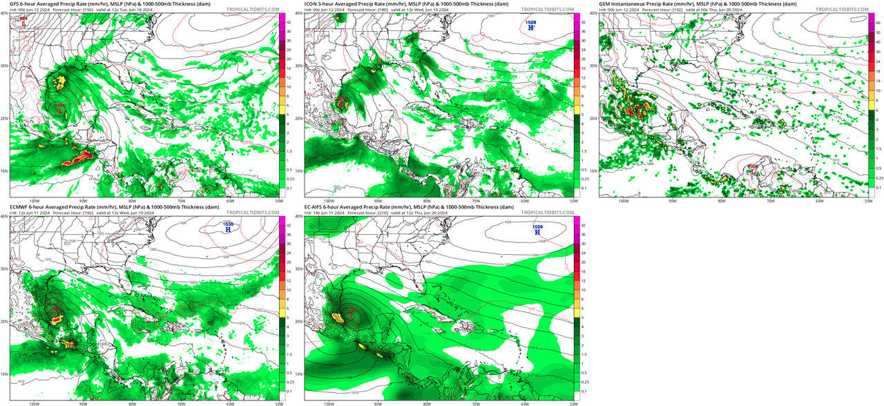
I think the Euro and ICON are on to the right idea in the extended range...should see tropical moisture pool over the western Gulf this weekend. Something could try to develop as it pushes inland, likely into northeastern Mexico. It's still early but this system could bring some much needed rainfall to portions of Mexico and south Texas next week.
It looks like the 12z GFS is trending towards this solution now as well.
It looks like the 12z GFS is trending towards this solution now as well.
1 likes

Re: 2024 Global Model Runs Discussion (Out thru day 16)
South Texas Storms wrote:I think the Euro and ICON are on to the right idea in the extended range...should see tropical moisture pool over the western Gulf this weekend. Something could try to develop as it pushes inland, likely into northeastern Mexico. It's still early but this system could bring some much needed rainfall to portions of Mexico and south Texas next week.
It looks like the 12z GFS is trending towards this solution now as well.
The Canucks look to be onboard
0 likes
Harvey,Hanna,Beta,Texas Winter storm2021,Nicholas,Beryl
-
Stratton23
- Category 5
- Posts: 3579
- Joined: Fri Jul 21, 2023 10:59 pm
- Location: Katy, Tx
Re: 2024 Global Model Runs Discussion (Out thru day 16)
We need to watch this closely, modes are trending toward a potentially significant rainfall event next week, south texas could use the rain, but with se texas seeing so much rain over the past month, this bears watching, this type of pattern someone could easily see double digit rainfall totals, just need to see how this evolves
2 likes
-
Category5Kaiju

- Category 5
- Posts: 4347
- Joined: Thu Dec 24, 2020 12:45 pm
- Location: Seattle during the summer, Phoenix during the winter
Re: 2024 Global Model Runs Discussion (Out thru day 16)
Wow, the GEFS ensembles explode with activity in the GoM at the end of next week. And the most recent GFS run has a 968 mbar hurricane hit the MS/AL coast. CMC's most recent run seems on board with the idea of some disturbance in the GoM at around the same timeframe too.
3 likes
Unless explicitly stated, all information in my posts is based on my own opinions and observations. Tropical storms and hurricanes can be extremely dangerous. Refer to an accredited weather research agency or meteorologist if you need to make serious decisions regarding an approaching storm.

Re: RE: Re: 2024 Global Model Runs Discussion (Out thru day 16)
Wow, yeah at hour 144, they light up like crazy. It's a lot of the members too. The Canadian ensembles show quite a few active members as well. Still a ways out, but the consistency isn't like the usual GFS ghost storm showing up for one or two runs and then disappearing. It could be a signal, though I'm not convinced yet.Category5Kaiju wrote:Wow, the GEFS ensembles explode with activity in the GoM at the end of next week. And the most recent GFS run has a 968 mbar hurricane hit the MS/AL coast. CMC's most recent run seems on board with the idea of some disturbance in the GoM at around the same timeframe too.
It wouldn't surprise me to see a hurricane in the Gulf. Usually, the area is held back in June by both climo conditions and SSTs. If the atmosphere cooperates even for a brief period, the energy is there, unlike most years.
3 likes

Re: 2024 Global Model Runs Discussion (Out thru day 16)
Category5Kaiju wrote:Wow, the GEFS ensembles explode with activity in the GoM at the end of next week. And the most recent GFS run has a 968 mbar hurricane hit the MS/AL coast. CMC's most recent run seems on board with the idea of some disturbance in the GoM at around the same timeframe too.
What’s the shear looking like around that time?
0 likes
-
StPeteMike

- Category 2

- Posts: 657
- Joined: Thu Jun 07, 2018 11:26 pm
Re: 2024 Global Model Runs Discussion (Out thru day 16)
I’ll give a few more runs and some other models jumping on before believing. Though GFS was wrong that 90L would form into a TS before visiting Florida, I believed it was correct in the increase moisture forecasting. And there’s still a chance that it can form after the state, the LLC is there. But the GFS also seems to get carried away sometimes after correctly forecasting one storm and wants to spit out multiples one after another. If the BoC storm actually develops, I’ll start believing more and more. 
1 likes
The above post is not official and should not be used as such. It is the opinion of the poster and may or may not be backed by sound meteorological data. It is not endorsed by any professional institution or storm2k.org. For official information, please refer to the NHC and NWS products.
-
crownweather

- S2K Supporter

- Posts: 602
- Age: 51
- Joined: Sat Aug 12, 2006 9:21 am
- Location: Sturbridge, Massachusetts
- Contact:
Re: 2024 Global Model Runs Discussion (Out thru day 16)
Hey, look at that number 1 analog!! Hmmm.....

0 likes
Rob Lightbown
Crown Weather Services
https://crownweather.com
Crown Weather Services
https://crownweather.com
-
Stratton23
- Category 5
- Posts: 3579
- Joined: Fri Jul 21, 2023 10:59 pm
- Location: Katy, Tx
Re: 2024 Global Model Runs Discussion (Out thru day 16)
StPeteMike the GFS isnt alone in the BOC system, its ensembles, The euro and its ensembles are also somewhat bullish on that, CMC operational agrees as well, support is on the higher side
0 likes
Re: 2024 Global Model Runs Discussion (Out thru day 16)
Usually in June shear is pretty high in the Gulf so I have my doubts.
0 likes
-
skyline385

- Category 5
- Posts: 2728
- Age: 35
- Joined: Wed Aug 26, 2020 11:15 pm
- Location: Houston TX
Re: 2024 Global Model Runs Discussion (Out thru day 16)
Its been a while since I have seen this level of agreement between models a week out (except timing being slightly off on the GFS), that BoC system is very likely happening. The genesis path seems to be the CAG over the CA as it moves northwards.
1 likes

Re: 2024 Global Model Runs Discussion (Out thru day 16)
chaser1 wrote:The greater model consensus would lean toward possible near-term (4-7 days) genesis to occur offshore N. Florida/Georgia coastline, but I don't buy it. I tend to think that a more "GFS centric" option just makes more sense. Development east of N. Fla would really need to find some incredible sweet spot. Other then within the Gulf stream itself, SST's up there are barely marginal at best. There's no need to even discuss the SST's in the GOM. More importantly, the overall wind shear forecast would appear fairly favorable (especially in the southern and Western GOM), while the present and forecast wind shear forecast east of N. Florida looks like trash. Lastly, there is very clear 850mb energy and broad cyclonic motion over Central America and emanating from the ITCZ bulging up from the E. Pacific. Throw in Climo and I think there's a reasonable case to anticipate the GFS to better hone-in on a weak to moderate TC to develop just north of Yucatan or BOC. Hey Northern Mexico/Texas, this "Bud's" for you
That was this past Monday (without model support). Two days later...... model support. Brownsville TX, this Bud's for you. Enjoy the rain.
0 likes
Andy D
(For official information, please refer to the NHC and NWS products.)
(For official information, please refer to the NHC and NWS products.)
-
Hypercane_Kyle

- Category 5
- Posts: 3465
- Joined: Sat Mar 07, 2015 7:58 pm
- Location: Cape Canaveral, FL
Re: 2024 Global Model Runs Discussion (Out thru day 16)
Broad ensemble support for a GOMEX tropical cyclone in ~7 days.

0 likes
My posts are my own personal opinion, defer to the National Hurricane Center (NHC) and other NOAA products for decision making during hurricane season.
-
Stratton23
- Category 5
- Posts: 3579
- Joined: Fri Jul 21, 2023 10:59 pm
- Location: Katy, Tx
Re: 2024 Global Model Runs Discussion (Out thru day 16)
One thing that may determine where this likely BOC system will track is where a low forms, half the members of the GEFS and GEPS develop the low in the BOC leading to a mexico landfall, but the other half of both ensembles develop the low on the eastern side of the yucatan because the energy in the pacific rotates around the broader cyclonic spin of the CAG, or in the NW caribbean, that has significant implications on regards to any sort of path this potential system could take, which would leave the door open to texas
1 likes
-
JetFuel_SE

- Category 1

- Posts: 288
- Age: 26
- Joined: Thu Apr 30, 2020 3:57 pm
Re: 2024 Global Model Runs Discussion (Out thru day 16)
Stratton23 wrote:One thing that may determine where this likely BOC system will track is where a low forms, half the members of the GEFS and GEPS develop the low in the BOC leading to a mexico landfall, but the other half of both ensembles develop the low on the eastern side of the yucatan because the energy in the pacific rotates around the broader cyclonic spin of the CAG, or in the NW caribbean, that has significant implications on regards to any sort of path this potential system could take, which would leave the door open to texas
I'd say anywhere from the Alabama/Mississippi border to Brownsville, TX is possible, assuming the 2nd scenario plays out.
0 likes
Re: 2024 Global Model Runs Discussion (Out thru day 16)
JetFuel_SE wrote:Stratton23 wrote:One thing that may determine where this likely BOC system will track is where a low forms, half the members of the GEFS and GEPS develop the low in the BOC leading to a mexico landfall, but the other half of both ensembles develop the low on the eastern side of the yucatan because the energy in the pacific rotates around the broader cyclonic spin of the CAG, or in the NW caribbean, that has significant implications on regards to any sort of path this potential system could take, which would leave the door open to texas
I'd say anywhere from the Alabama/Mississippi border to Brownsville, TX is possible, assuming the 2nd scenario plays out.
The only reason that I would tend to lean contrary to a N. GOM solutions (in the near/mid term) would be given the robust shear forecast. I think that the sub-tropical jet across the GOM would inhibit vertical development. A more "southern" solution such as the Bay of Campeche would seem to provide a far more conducive upper air environment. That's not to say that initial genesis couldn't occur in the far W. Caribbean but a west to WNW motion might be key for a respectable T.S. to develop. I suppose Cuba/Florida Keys could well play out assuming that the stronger upper level shear remain just north of S. Florida.
0 likes
Andy D
(For official information, please refer to the NHC and NWS products.)
(For official information, please refer to the NHC and NWS products.)
-
REDHurricane

- Category 1
- Posts: 438
- Age: 28
- Joined: Sun Jul 03, 2022 2:36 pm
- Location: Northeast Pacific Ocean
Re: 2024 Global Model Runs Discussion (Out thru day 16)
Looking ahead past the potential BoC system everyone's talking about for next week, I noticed that the GFS has consistently (6 out the last 8 runs) forecast a system trying to form somewhere in the Gulf/NW Caribbean around 10-11 days out -- still a ways to go before anyone should be seriously concerned, but given the environment I think it's certainly worth monitoring over the next several days in addition to the BoC system:
0 likes
-
cycloneye
- Admin

- Posts: 149746
- Age: 69
- Joined: Thu Oct 10, 2002 10:54 am
- Location: San Juan, Puerto Rico
Re: 2024 Global Model Runs Discussion (Out thru day 16)
The model runs for the BOC area are being posted at the thread for that area.
https://www.storm2k.org/phpbb2/viewtopi ... 0#p3066690
https://www.storm2k.org/phpbb2/viewtopi ... 0#p3066690
0 likes
Visit the Caribbean-Central America Weather Thread where you can find at first post web cams,radars
and observations from Caribbean basin members Click Here
and observations from Caribbean basin members Click Here
-
Ivanhater

- Storm2k Moderator

- Posts: 11222
- Age: 39
- Joined: Fri Jul 01, 2005 8:25 am
- Location: Pensacola
Re: 2024 Global Model Runs Discussion (Out thru day 16)
REDHurricane wrote:Looking ahead past the potential BoC system everyone's talking about for next week, I noticed that the GFS has consistently (6 out the last 8 runs) forecast a system trying to form somewhere in the Gulf/NW Caribbean around 10-11 days out -- still a ways to go before anyone should be seriously concerned, but given the environment I think it's certainly worth monitoring over the next several days in addition to the BoC system:
https://media2.giphy.com/media/v1.Y2lkPTc5MGI3NjExMXY0NHQxNjJmbzQ1dm1jN3NrY2pnMnQ1ZDF4ZDdhMXYzNW1hajdreiZlcD12MV9pbnRlcm5hbF9naWZfYnlfaWQmY3Q9Zw/3BF0hTGJEcrq4ZerAI/giphy.gif
Great post. A lot of times with a CAG set-up, it will spawn a couple system. After the BOC system, the north eastern lobe spits off another system which may find better conditions in the Gulf and threaten the Gulf coast
0 likes
Michael
Who is online
Users browsing this forum: No registered users and 142 guests