2024 Global Model Runs Discussion (Out thru day 16)
Moderator: S2k Moderators
Forum rules

The posts in this forum are NOT official forecasts and should not be used as such. They are just the opinion of the poster and may or may not be backed by sound meteorological data. They are NOT endorsed by any professional institution or STORM2K. For official information, please refer to products from the National Hurricane Center and National Weather Service.

Re: 2024 Global Model Runs Discussion (Out thru day 16)
This does have the potential makings for eventual PTC Watches/Warnings and eventual (unnecessary) naming of a short-life 40-45 kt. N.E. quad. gradient-cane. Oh NAM.... we turn our lonely eyes to you....  Hey, I'm personally hopeful for no other reason than to help green up our brown Florida lawns! Gotta look out for some model run to run consistency though
3 likes
Andy D
(For official information, please refer to the NHC and NWS products.)
(For official information, please refer to the NHC and NWS products.)
-
StPeteMike

- Category 2

- Posts: 657
- Joined: Thu Jun 07, 2018 11:26 pm
Re: 2024 Global Model Runs Discussion (Out thru day 16)
That’s what I’m banking on. Anything below 60 mph tropical storm that is right-heavy when it comes to precipitation, I will take!
Watch the 0z GFS drop all increased moisture…
Watch the 0z GFS drop all increased moisture…
0 likes
The above post is not official and should not be used as such. It is the opinion of the poster and may or may not be backed by sound meteorological data. It is not endorsed by any professional institution or storm2k.org. For official information, please refer to the NHC and NWS products.

Re: 2024 Global Model Runs Discussion (Out thru day 16)
06z GFS has a slower-moving system which eventually becomes a TC in the GOM.

0 likes
-
Stratton23
- Category 5

- Posts: 3577
- Joined: Fri Jul 21, 2023 10:59 pm
- Location: Katy, Tx
Re: 2024 Global Model Runs Discussion (Out thru day 16)
A slower moving system would give more time for the heat ridge to expand and move eastward preventing a northward motion into florida, storm would be forced more NW towards the central or even western gulf coast, just gotta keep watching it
0 likes
-
wxman57

- Moderator-Pro Met

- Posts: 23175
- Age: 68
- Joined: Sat Jun 21, 2003 8:06 pm
- Location: Houston, TX (southwest)
Re: 2024 Global Model Runs Discussion (Out thru day 16)
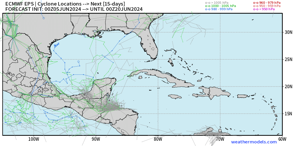
Still not buying the GFS at all. It's all alone in the prediction of a Gulf TS/H. It may be right in predicting some moisture moving across the Gulf next week, but that's about it.
1 likes
-
skyline385

- Category 5
- Posts: 2728
- Age: 35
- Joined: Wed Aug 26, 2020 11:15 pm
- Location: Houston TX
Re: 2024 Global Model Runs Discussion (Out thru day 16)
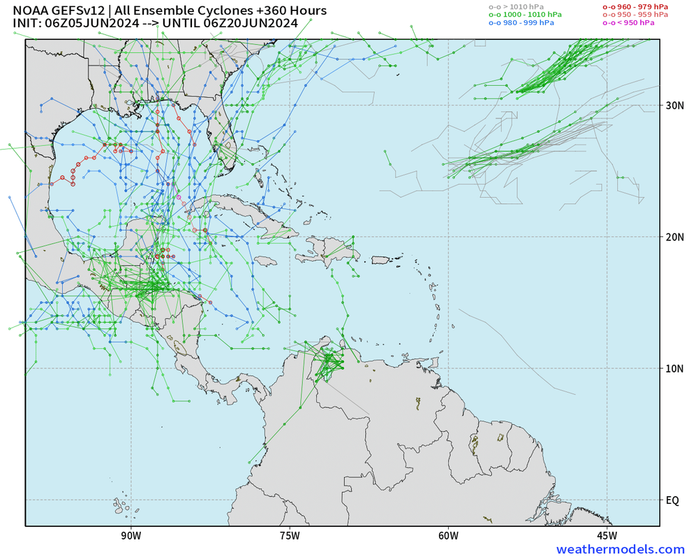
GEFS and EPS are still quite far off from each other and knowing GFS' history I tend to believe more towards the EPS' chances
2 likes
-
Kingarabian

- S2K Supporter

- Posts: 16379
- Joined: Sat Aug 08, 2009 3:06 am
- Location: Honolulu, Hawaii
Re: 2024 Global Model Runs Discussion (Out thru day 16)
From the CAG, Euro has a TC in the EPAC while the GFS has it in the GOM.
2 likes
RIP Kobe Bryant
-
lsuhurricane
- Category 1

- Posts: 270
- Joined: Tue Aug 15, 2017 2:53 pm
Re: 2024 Global Model Runs Discussion (Out thru day 16)
Would appear that both the 12s suites of GFS and CMC are both sniffing development around the Yucatan 6-7 day range.
Upper level continental shear appears to be prohibiting factor in both cases.
Upper level continental shear appears to be prohibiting factor in both cases.
0 likes
-
Ivanhater

- Storm2k Moderator

- Posts: 11222
- Age: 39
- Joined: Fri Jul 01, 2005 8:25 am
- Location: Pensacola
Re: RE: Re: 2024 Global Model Runs Discussion (Out thru day 16)
12 Z Canadian jumps onboard with GFSwxman57 wrote:Still not buying the GFS at all. It's all alone in the prediction of a Gulf TS/H. It may be right in predicting some moisture moving across the Gulf next week, but that's about it.

Sent from my motorola razr plus 2023 using Tapatalk
2 likes
Michael
-
wxman57
- Moderator-Pro Met
- Posts: 23175
- Age: 68
- Joined: Sat Jun 21, 2003 8:06 pm
- Location: Houston, TX (southwest)
Re: RE: Re: 2024 Global Model Runs Discussion (Out thru day 16)
Ivanhater wrote:12 Z Canadian jumps onboard with GFS https://uploads.tapatalk-cdn.com/20240605/79468a9a516a2c88ae8524ec7fc99d75.jpgwxman57 wrote:Still not buying the GFS at all. It's all alone in the prediction of a Gulf TS/H. It may be right in predicting some moisture moving across the Gulf next week, but that's about it.
Sent from my motorola razr plus 2023 using Tapatalk
I think that there is a good chance moisture will move across the Gulf toward Florida next week. 12Z GFS is backing off on the TS/H forecast in favor of a weak low.
0 likes
Re: 2024 Global Model Runs Discussion (Out thru day 16)
A non storm is the likely scenario. Hopefully we get a slug of deep tropical moisture pulling up and over Florida to help jump start our rainy season. That appears increasingly likely
1 likes
-
Stratton23
- Category 5
- Posts: 3577
- Joined: Fri Jul 21, 2023 10:59 pm
- Location: Katy, Tx
Re: 2024 Global Model Runs Discussion (Out thru day 16)
Euro looks like it is slowly caving towards the GFS with a weak circulation trying to develop, but instead of florida ita taking whatever “ circulation “ their is or even a strong open wave, further west , its sitting in the NW gulf, but do to what will likey be a very broad system, florida should still see a good amount of rain, unfortunately the GFS and Euro have trended toward the front that supposed to come down and stall, weakening and allowing high pressure to build in over the central US, blocking this system from truely coming ashore in florida, Euro takes it toward florida initially, but then feels the ridge and gets shunted off to the west
0 likes

Re: 2024 Global Model Runs Discussion (Out thru day 16)
Stratton23 wrote:Euro looks like it is slowly caving towards the GFS with a weak circulation trying to develop, but instead of florida ita taking whatever “ circulation “ their is or even a strong open wave, further west , its sitting in the NW gulf, but do to what will likey be a very broad system, florida should still see a good amount of rain, unfortunately the GFS and Euro have trended toward the front that supposed to come down and stall, weakening and allowing high pressure to build in over the central US, blocking this system from truely coming ashore in florida, Euro takes it toward florida initially, but then feels the ridge and gets shunted off to the west
12Z euro 24hr QPF amount forecast shows storms entering the gulf from the Caribbean starting about Tuesday
next week. Looks like most of the precip will be from the eastern quadrants of the surface low but the system persists out past 230 hours so there would be time for a low level center to gradually form.
0 likes
-
cycloneye

- Admin

- Posts: 149727
- Age: 69
- Joined: Thu Oct 10, 2002 10:54 am
- Location: San Juan, Puerto Rico
Re: 2024 Global Model Runs Discussion (Out thru day 16)
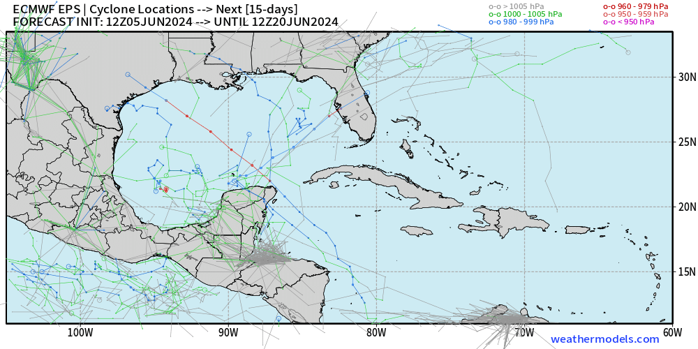
The new Euro EC-AIFS has a storm in NW GOM, but is at 360 hours.

2 likes
Visit the Caribbean-Central America Weather Thread where you can find at first post web cams,radars
and observations from Caribbean basin members Click Here
and observations from Caribbean basin members Click Here
Re: 2024 Global Model Runs Discussion (Out thru day 16)
WPC and CPC guidance is tilting wet over the Florida peninsula which fits well with climo along with the expected longwave pattern over north America. Probably a slug of tropical juice gets pulled north and northeast ward over FL. At this early point...looking for trends in those products is probably the best course of action.
2 likes
-
skyline385
- Category 5
- Posts: 2728
- Age: 35
- Joined: Wed Aug 26, 2020 11:15 pm
- Location: Houston TX
Re: 2024 Global Model Runs Discussion (Out thru day 16)
cycloneye wrote:The new Euro EC-AIFS has a storm in NW GOM, but is at 360 hours.
https://i.imgur.com/QWH5n2t.png
That looks just like the one strong EPS member from 12z, AIFS has been performing great for mid latitude features afaik
1 likes
-
jlauderdal
- S2K Supporter
- Posts: 7240
- Joined: Wed May 19, 2004 5:46 am
- Location: NE Fort Lauderdale
- Contact:
Re: RE: Re: 2024 Global Model Runs Discussion (Out thru day 16)
The atlantic basin isnt ready, we see this every year, lots of early season noise, minimal development. Listen to wxman57. Take this time to prepare, everyone has been warned.skyline385 wrote:cycloneye wrote:The new Euro EC-AIFS has a storm in NW GOM, but is at 360 hours.
https://i.imgur.com/QWH5n2t.png
That looks just like the one strong EPS member from 12z, AIFS has been performing great for mid latitude features afaik
1 likes
-
DunedinDave
- Category 1
- Posts: 269
- Joined: Fri Aug 25, 2023 10:31 am
Re: RE: Re: 2024 Global Model Runs Discussion (Out thru day 16)
jlauderdal wrote:The atlantic basin isnt ready, we see this every year, lots of early season noise, minimal development. Listen to wxman57. Take this time to prepare, everyone has been warned.skyline385 wrote:cycloneye is wrote:The new Euro EC-AIFS has a storm in NW GOM, but is at 360 hours.
https://i.imgur.com/QWH5n2t.png
That looks just like the one strong EPS member from 12z, AIFS has been performing great for mid latitude features afaik
[url]https://i.postimg.cc/B64wb1yJ/image.png [/url]
I’ll admit I was expecting something early in June given the forecasts and how hot the water is already. A lot of times we get something the first half of June and then get nothing until late August.
0 likes
-
Stratton23
- Category 5
- Posts: 3577
- Joined: Fri Jul 21, 2023 10:59 pm
- Location: Katy, Tx
Re: 2024 Global Model Runs Discussion (Out thru day 16)
The rising air phase of the MJO or positive phase will be settling in over the atlantic basin soon, so i do expect to see activity increasing as we get past mid month (13th or so and beyond)
0 likes
-
Hurricane2022

- Category 5
- Posts: 2093
- Joined: Tue Aug 23, 2022 11:38 pm
- Location: Araçatuba, Brazil
Re: 2024 Global Model Runs Discussion (Out thru day 16)
Can we now start canceling 2024 or is it too early? 

2 likes
Sorry for the bad English sometimes...!
For reliable and detailed information for any meteorological phenomenon, please consult the National Hurricane Center, Joint Typhoon Warning Center , or your local Meteo Center.
--------
ECCE OMNIA NOVA FACIAM (Ap 21,5).
For reliable and detailed information for any meteorological phenomenon, please consult the National Hurricane Center, Joint Typhoon Warning Center , or your local Meteo Center.
--------
ECCE OMNIA NOVA FACIAM (Ap 21,5).
Who is online
Users browsing this forum: Ulf and 119 guests