 pouring out here in Shackelford County
Texas Fall 2023
Moderator: S2k Moderators
Forum rules

The posts in this forum are NOT official forecast and should not be used as such. They are just the opinion of the poster and may or may not be backed by sound meteorological data. They are NOT endorsed by any professional institution or STORM2K.
-
Fifty Rock
- Tropical Storm

- Posts: 153
- Joined: Mon Sep 11, 2023 10:08 am
- Location: Albany, Texas
-
cheezyWXguy

- Category 5

- Posts: 6282
- Joined: Mon Feb 13, 2006 12:29 am
- Location: Dallas, TX
Re: Texas Fall 2023
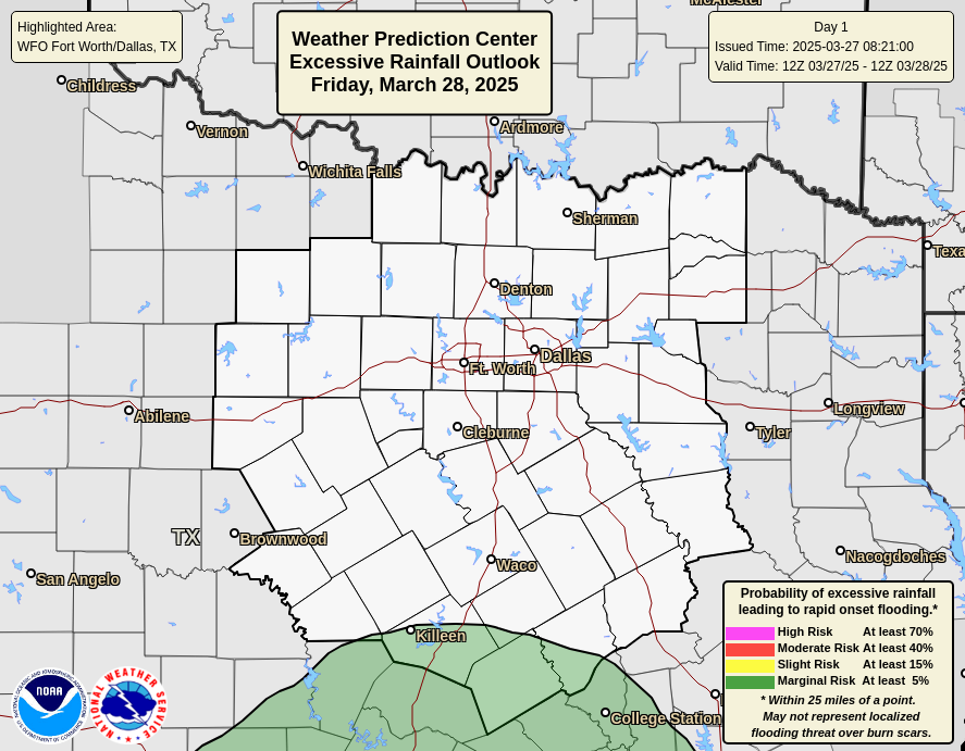
Moderate risk of excessive rainfall was expanded east in the latest update, looks like it includes the dfw metro now
3 likes
-
rwfromkansas
- Category 5
- Posts: 3038
- Joined: Sat Aug 27, 2005 12:47 am
- Location: North Fort Worth
Re: Texas Fall 2023
The line seems to be moving pretty fast east, not sure if that will have much of an impact. But FWD did say they will expand the watch east.
1 likes
-
HockeyTx82
- S2K Supporter

- Posts: 2797
- Joined: Tue Oct 27, 2009 11:17 am
- Location: Ponder, TX
Re: Texas Fall 2023
That storm in front of the line SW of Fort Worth, is that a supercell?
0 likes
Don't hold me accountable for anything I post on this forum. Leave the real forecasting up to the professionals.
Location: Ponder, TX (all observation posts are this location unless otherwise noted)
Location: Ponder, TX (all observation posts are this location unless otherwise noted)
-
bubba hotep

- S2K Supporter
- Posts: 6014
- Joined: Wed Dec 28, 2016 1:00 am
- Location: Collin County Texas
Re: Texas Fall 2023
cheezyWXguy wrote:Moderate risk of excessive rainfall was expanded east in the latest update, looks like it includes the dfw metro now
2 likes
Winter time post are almost exclusively focused on the DFW area.
-
Fifty Rock
- Tropical Storm
- Posts: 153
- Joined: Mon Sep 11, 2023 10:08 am
- Location: Albany, Texas
Re: Texas Fall 2023
rwfromkansas wrote:The line seems to be moving pretty fast east, not sure if that will have much of an impact. But FWD did say they will expand the watch east.
We got just over 2 inches out of the front end of the line out in Shackelford County and still have rain falling. Most of the storms are heading Northeast while the line is moving East at a slower pace. It's also picked up in intensity on radar. Would not be surprised to see the metro with a few inches as well.
1 likes
-
cheezyWXguy
- Category 5
- Posts: 6282
- Joined: Mon Feb 13, 2006 12:29 am
- Location: Dallas, TX
Re: Texas Fall 2023
HockeyTx82 wrote:That storm in front of the line SW of Fort Worth, is that a supercell?
Doesn’t look like much to me at this point, but an outside shot of a tornado is possible later this evening with storms along or ahead of the line. SPC highlights a 2% risk for the area, as low level shear should improve tonight, but capping of the surface and meager instability should keep things in check for the most part
0 likes

Re: Texas Fall 2023
They also increased the rainfall totals in the flood watch to 2-5 inches with isolated 7+ possible.
1 likes
-
rwfromkansas
- Category 5
- Posts: 3038
- Joined: Sat Aug 27, 2005 12:47 am
- Location: North Fort Worth
Re: Texas Fall 2023
That cell coming up into the FW area will probably help ramp up totals a bit ahead of the main line.
Radarscope can be a bit deceiving when you zoom in when I thought it was moving faster, but really the line overall is pretty slow. With things filling in, could have some flooding issues.
Radarscope can be a bit deceiving when you zoom in when I thought it was moving faster, but really the line overall is pretty slow. With things filling in, could have some flooding issues.
1 likes
-
jasons2k

- Storm2k Executive

- Posts: 8290
- Age: 52
- Joined: Wed Jul 06, 2005 12:32 pm
- Location: The Woodlands, TX
Re: Texas Fall 2023
We’ve had a few showers at my office in The Woodlands. Doesn’t look like anything at the house yet though.
0 likes
-
WacoWx
- Category 2

- Posts: 692
- Joined: Mon Dec 28, 2009 4:14 pm
- Location: NOT Waco, TX ----> Dallas, TX
Re: Texas Fall 2023
Is this current line to the west of DFW the line that was supposed to be arriving ~9:00p?
0 likes


Re: Texas Fall 2023
WacoWx wrote:Is this current line to the west of DFW the line that was supposed to be arriving ~9:00p?
Yes, it was over Abilene this morning and taken a long time to get close to I-35W. Some models take the bulk and shifts it north and fades the line out to the south. Dewpoints are in the 70s ahead of it, hopefully we will overperform.
0 likes
The above post and any post by Ntxw is NOT an official forecast and should not be used as such. It is just the opinion of the poster and may or may not be backed by sound meteorological data. It is NOT endorsed by any professional institution including Storm2k. For official information, please refer to NWS products.
Help support Storm2K!
-
bubba hotep
- S2K Supporter
- Posts: 6014
- Joined: Wed Dec 28, 2016 1:00 am
- Location: Collin County Texas
Re: Texas Fall 2023

Mesoscale Precipitation Discussion 1159
NWS Weather Prediction Center College Park MD
607 PM EDT Wed Oct 25 2023
Areas affected...South-Central Texas into South-Central Oklahoma
Concerning...Heavy rainfall...Flash flooding likely
Valid 252206Z - 260405Z
SUMMARY...Axis of heavy thunderstorms continues to drift east to
the Texas I-35 corridor through this evening. Rainfall of 2 to 5"
should cause scattered flash flooding through this evening.
DISCUSSION...Upper trough will continue to lift northeast from its
current position over eastern New Mexico through this evening. A
scattered line of thunderstorms continues to develop along a
surface trough on the east side of the dry conveyor belt/SSWly jet
east of this upper trough axis which remains anchored near Del Rio
with the northern portion drifting east over North Texas and
south-central OK. This area is in the right entrance region of
this SSWly jet which is aiding lift and further development. 30kt
southerly low level flow is providing ample moisture
advection/1.8" PW from south Texas where tropical moisture ahead
of the remnants of Otis is streaming in. Repeating activity is
occurring with slow eastward movement and recent max hourly
rainfall estimates are 1 to 2" from regional radars.
This slow eastward progression of heavy thunderstorms will persist
through the evening with deep mean layer flow holding steady at
SSWly around 40kt with SWly upwind propagation vectors and cold
pool development providing an eastward nudge. PWs surge up around
2" (2.5 to 3 standard deviations above normal) this evening,
particularly with the increasing LLJ with Sly 850mb flow reaching
35kt this evening. SBCAPE of 1000-2000 J/kg will allow
redevelopment with repeating activity bringing max hourly rainfall
up to 3". Recent HRRRs continue to project six-hour totals of 5",
but with the increased PWs these totals may be more common than
this afternoon. With 3hr FFG generally 2 to 2.5", scattered flash
flooding is considered likely, especially as the activity
approaches the more urbanized I-35 corridor.
Further development of heavy rain is likely overnight, so further
MPDs are expected on this prolonged heavy rainfall event lasting
through tonight.
Jackson
ATTN...WFO...EWX...FWD...OUN...SJT...
ATTN...RFC...ABRFC...WGRFC...NWC...
2 likes
Winter time post are almost exclusively focused on the DFW area.
-
rwfromkansas
- Category 5
- Posts: 3038
- Joined: Sat Aug 27, 2005 12:47 am
- Location: North Fort Worth
Re: Texas Fall 2023
Quite a few gaps in the line so it’s only rained heavily in small spirts. But, it is heavy when it does.
1 likes
-
tajmahal
- Tropical Storm
- Posts: 168
- Age: 68
- Joined: Tue Jan 10, 2012 10:09 am
- Location: Austin, TX area & eastern Africa
Re: Texas Fall 2023
Still no flash flood watch for the IH–35 corridor from Williamson County southwards.
0 likes
-
tajmahal
- Tropical Storm
- Posts: 168
- Age: 68
- Joined: Tue Jan 10, 2012 10:09 am
- Location: Austin, TX area & eastern Africa
Re: Texas Fall 2023
lukem wrote:Will Otis bring moisture to Texas or is it making landfall to far south? Just 18 hours ago they were expecting a tropical storm, so I bet most of the models were discounting it. Praying for those in Mexico that are in its Path.
Yes, it will tonight into Thursday morning according to the U. S. Weather Prediction Center.
0 likes
-
rwfromkansas
- Category 5
- Posts: 3038
- Joined: Sat Aug 27, 2005 12:47 am
- Location: North Fort Worth
Re: Texas Fall 2023
Okay, that was impressive. Got 2.50 inch an hour rates currently, pouring.
Up to 1.20 today. So approaching 2.50 total, not bad!
Up to 1.20 today. So approaching 2.50 total, not bad!
3 likes
Re: Texas Fall 2023
gpsnowman wrote:This is the slowest moving batch of rain I have ever seen.
Yet it's a walk in the park for Houston. LOL
0 likes
-
HockeyTx82
- S2K Supporter
- Posts: 2797
- Joined: Tue Oct 27, 2009 11:17 am
- Location: Ponder, TX
Re: Texas Fall 2023
1.48" and counting for the day.
2.91" and counting for the last three days.....
My digital rain bucket here in Ponder

2.91" and counting for the last three days.....
My digital rain bucket here in Ponder
3 likes
Don't hold me accountable for anything I post on this forum. Leave the real forecasting up to the professionals.
Location: Ponder, TX (all observation posts are this location unless otherwise noted)
Location: Ponder, TX (all observation posts are this location unless otherwise noted)
Return to “USA & Caribbean Weather”
Who is online
Users browsing this forum: No registered users and 84 guests