EPAC: OTIS - Aftermath - Discussion
Moderator: S2k Moderators
-
doomhaMwx

- Category 5

- Posts: 2495
- Age: 27
- Joined: Tue Apr 18, 2017 4:01 am
- Location: Baguio/Benguet, Philippines
- Contact:
Re: EPAC: OTIS - Hurricane - Discussion
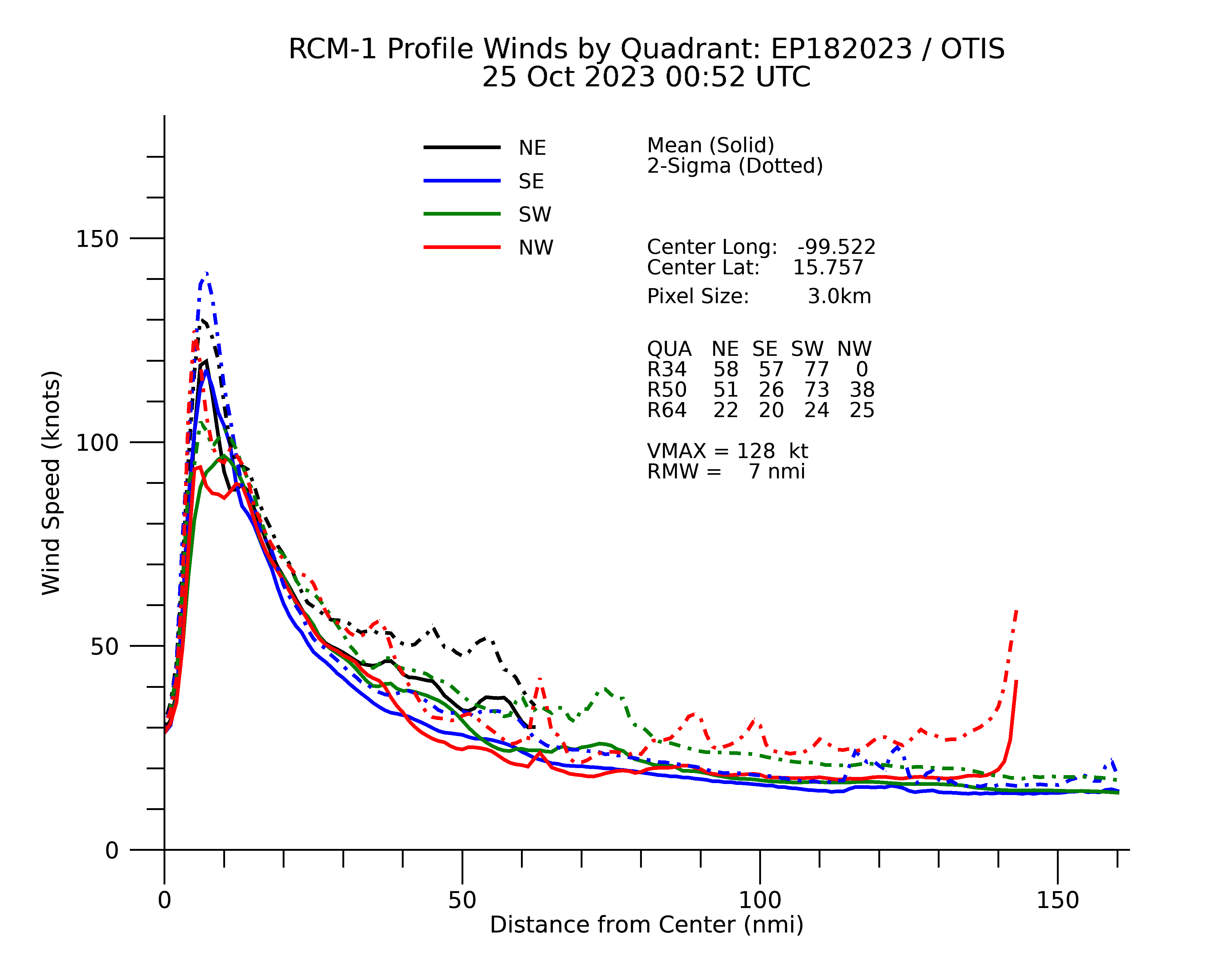
SAR pass at ~00Z found 128kts. Matches well with NHC's estimate at that time.
0 likes
-
CrazyC83
- Professional-Met

- Posts: 34316
- Joined: Tue Mar 07, 2006 11:57 pm
- Location: Deep South, for the first time!
Re: EPAC: OTIS - Hurricane - Discussion
Astromanía wrote:Does anyone know which was the strongest hurricane by wind speed to make landfall on Mexico? I know Gilbert had 140 kt at landfall but Idk about Dean
Dean was 150 kt, and I believe Janet in 1955 was as well.
Strongest on the EPAC side was Patricia (130 kt).
4 likes

Re: EPAC: OTIS - Hurricane - Discussion
If one is thinking about storm surge from a small system, Hurricane Andrew's surge was about 8ft.
0 likes
-
Astromanía
- Category 2

- Posts: 798
- Age: 27
- Joined: Sat Aug 25, 2018 10:34 pm
- Location: Monterrey, N.L, México
Re: EPAC: OTIS - Hurricane - Discussion
So this means it has a shot to be the strongest landfalling hurricane by wind speed in overall Mexico as well? 
1 likes
-
CrazyC83
- Professional-Met
- Posts: 34316
- Joined: Tue Mar 07, 2006 11:57 pm
- Location: Deep South, for the first time!
Re: EPAC: OTIS - Hurricane - Discussion
Astromanía wrote:So this means it has a shot to be the strongest landfalling hurricane by wind speed in overall Mexico as well?
That's correct.
If it hits at 155 kt or higher, it would be the strongest storm to EVER hit the North American mainland I believe. The only landfalls at such intensities were on islands.
7 likes
-
cheezyWXguy

- Category 5
- Posts: 6282
- Joined: Mon Feb 13, 2006 12:29 am
- Location: Dallas, TX
Re: EPAC: OTIS - Hurricane - Discussion
shah83 wrote:If one is thinking about storm surge from a small system, Hurricane Andrew's surge was about 8ft.
Andrew’s surge was kept low by the small continental shelf and sharp water depth increase off the east coast of Florida. Not sure of the characteristics of the shelf off the west coast of mexico, but Acapulco being on a bay will likely result in higher surge values from water being funneled in
Last edited by cheezyWXguy on Tue Oct 24, 2023 11:55 pm, edited 1 time in total.
0 likes

Re: EPAC: OTIS - Hurricane - Discussion
shah83 wrote:If one is thinking about storm surge from a small system, Hurricane Andrew's surge was about 8ft.
16.9 feet in S. Florida: 15 miles S. of downtown Miami, 11 miles north of Homestead was highest

2 likes
List of 79 tropical cyclones intercepted by Richard Horodner:
http://www.canebeard.com/page/page/572246.htm
former storm2k screenname Beoumont 2009+
http://www.canebeard.com/page/page/572246.htm
former storm2k screenname Beoumont 2009+
-
CrazyC83
- Professional-Met
- Posts: 34316
- Joined: Tue Mar 07, 2006 11:57 pm
- Location: Deep South, for the first time!
Re: EPAC: OTIS - Hurricane - Discussion
Hurricane Otis Tropical Cyclone Update
NWS National Hurricane Center Miami FL EP182023
1200 AM CDT Wed Oct 25 2023
...EYEWALL OF POTENTIALLY CATASTROPHIC CATEGORY 5 HURRICANE OTIS
MOVING ASHORE NEAR ACAPULCO MEXICO...
...12 AM POSITION UPDATE...
Satellite imagery indicates that the eyewall of potentially
catastrophic Hurricane Otis is moving ashore the southern coast of
Mexico near Acapulco. Maximum sustained winds are estimated to be
165 mph (270 km/h) with higher gusts. Otis is a category 5
hurricane on the Saffir-Simpson Hurricane Wind Scale. Otis is
forecast to remain a category 5 hurricane through landfall within
the next few hours.
SUMMARY OF 1200 AM CDT...0500 UTC...INFORMATION
-----------------------------------------------
LOCATION...16.5 99.7W
ABOUT 30 MI...50 KM SSE OF ACAPULCO MEXICO
MAXIMUM SUSTAINED WINDS...165 MPH...270 KM/H
PRESENT MOVEMENT...NNW OR 345 DEGREES AT 9 MPH...15 KM/H
MINIMUM CENTRAL PRESSURE...923 MB...27.26 INCHES
$$
Forecaster Brown/Kelly
0 likes
-
CrazyC83
- Professional-Met
- Posts: 34316
- Joined: Tue Mar 07, 2006 11:57 pm
- Location: Deep South, for the first time!
Re: EPAC: OTIS - Hurricane - Discussion
The true eyewall is probably still 1-2 hours away but winds are likely at hurricane force now at least nearby.
I suspect landfall will be around 4 am CDT at this rate.
I suspect landfall will be around 4 am CDT at this rate.
2 likes
Re: EPAC: OTIS - Hurricane - Discussion
Are there any reliable weather stations in Acapulco that would provide data that might help with a better guesstimate as to peak intensity?
This is truly a nightmare scenario. It happened so fast and unexpectedly that no one really had time to prepare for a Cat 5 buzzsaw, especially in a location that has never seen a major hurricane and barely sees tropical system landfalls of any sort as is.
This feels rather like the hurricane version of the Joplin EF5. A sudden surprise monster strikes a major population center. Hoping that the people of Acapulco pull through and it surprises everyone by falling WAY short of the anticipated catastrophe.
7 likes
Solar Aquarian
Lunar Cancerian
 Sagittarian
Lunar Cancerian

Re: EPAC: OTIS - Hurricane - Discussion
Seeing Acapulco on this loop makes me sick.
https://twitter.com/zoom_earth/status/1717039322858176677
Edit to add this:
https://twitter.com/pppapin/status/1717049289514365163
https://twitter.com/zoom_earth/status/1717039322858176677
Edit to add this:
https://twitter.com/pppapin/status/1717049289514365163
0 likes
TC naming lists: retirements and intensity
Most aggressive Advisory #1's in North Atlantic (cr. kevin for starting the list)
Most aggressive Advisory #1's in North Atlantic (cr. kevin for starting the list)
-
CrazyC83
- Professional-Met
- Posts: 34316
- Joined: Tue Mar 07, 2006 11:57 pm
- Location: Deep South, for the first time!
Re: EPAC: OTIS - Hurricane - Discussion
Chris90 wrote:Are there any reliable weather stations in Acapulco that would provide data that might help with a better guesstimate as to peak intensity?
This is truly a nightmare scenario. It happened so fast and unexpectedly that no one really had time to prepare for a Cat 5 buzzsaw, especially in a location that has never seen a major hurricane and barely sees tropical system landfalls of any sort as is.
This feels rather like the hurricane version of the Joplin EF5. A sudden surprise monster strikes a major population center. Hoping that the people of Acapulco pull through and it surprises everyone by falling WAY short of the anticipated catastrophe.
I'm not sure, although I would think we would get some unofficial pressure readings after the fact. The airport - if it holds up - might get some data too.
2 likes
Re: EPAC: OTIS - Hurricane - Discussion
There may be some parallax error coming from both GOES-16 and GOES-18 satellites due to their large viewing angles. Unfortunately there is no radar coverage and we can’t even pinpoint the exact location.
Location estimates from satellites can be off by 10 to 20 miles at such a large angle.
Location estimates from satellites can be off by 10 to 20 miles at such a large angle.
1 likes
Personal Forecast Disclaimer:
The posts in this forum are NOT official forecast and should not be used as such. They are just the opinion of the poster and may or may not be backed by sound meteorological data. They are NOT endorsed by any professional institution or storm2k.org. For official information, please refer to RSMC and NWS products.
The posts in this forum are NOT official forecast and should not be used as such. They are just the opinion of the poster and may or may not be backed by sound meteorological data. They are NOT endorsed by any professional institution or storm2k.org. For official information, please refer to RSMC and NWS products.
-
Astromanía
- Category 2
- Posts: 798
- Age: 27
- Joined: Sat Aug 25, 2018 10:34 pm
- Location: Monterrey, N.L, México
Re: EPAC: OTIS - Hurricane - Discussion
It is already weakening due to land interaction, dont know if it will stay at 165 mph at landfall
0 likes
Re: EPAC: OTIS - Hurricane - Discussion
Hurricane Otis Intermediate Advisory Number 12A
NWS National Hurricane Center Miami FL EP182023
100 AM CDT Wed Oct 25 2023
...EYE OF CATEGORY 5 HURRICANE OTIS ABOUT TO MAKE LANDFALL NEAR
ACAPULCO MEXICO...
...CATASTROPHIC DAMAGE LIKELY WHERE THE CORE MOVES ONSHORE...
SUMMARY OF 100 AM CDT...0600 UTC...INFORMATION
----------------------------------------------
LOCATION...16.7N 99.8W
ABOUT 15 MI...25 KM SSE OF ACAPULCO MEXICO
MAXIMUM SUSTAINED WINDS...165 MPH...270 KM/H
PRESENT MOVEMENT...NNW OR 345 DEGREES AT 10 MPH...17 KM/H
MINIMUM CENTRAL PRESSURE...923 MB...27.26 INCHES
0 likes
TC naming lists: retirements and intensity
Most aggressive Advisory #1's in North Atlantic (cr. kevin for starting the list)
Most aggressive Advisory #1's in North Atlantic (cr. kevin for starting the list)
-
mmmmsnouts
- Tropical Storm

- Posts: 217
- Joined: Tue Sep 05, 2023 10:04 pm
- Location: Arlington, TX
Re: EPAC: OTIS - Hurricane - Discussion
Chris90 wrote:This is truly a nightmare scenario. It happened so fast and unexpectedly that no one really had time to prepare for a Cat 5 buzzsaw, especially in a location that has never seen a major hurricane and barely sees tropical system landfalls of any sort as is.
This feels rather like the hurricane version of the Joplin EF5. A sudden surprise monster strikes a major population center. Hoping that the people of Acapulco pull through and it surprises everyone by falling WAY short of the anticipated catastrophe.
I was thinking if I was in this situation, I wouldn’t even try to prepare my house. There’s not enough time and it would probably be a futile effort anyway. I would treat it like an EF5, grab my valuables and ID and medicine and some clothes and just get out of there.
1 likes
-
CrazyC83
- Professional-Met
- Posts: 34316
- Joined: Tue Mar 07, 2006 11:57 pm
- Location: Deep South, for the first time!
Re: EPAC: OTIS - Hurricane - Discussion
Webcams suggest that the eyewall is starting to come in. 90% of Acapulco was without power at 0500Z, which was about the time it came in. It will quickly become 100% and structural damage should begin soon.
1 likes
-
ElectricStorm

- Category 5
- Posts: 5155
- Age: 25
- Joined: Tue Aug 13, 2019 11:23 pm
- Location: Norman, OK
Re: EPAC: OTIS - Hurricane - Discussion
Praying for everyone involved, this is unbelievable...
2 likes
B.S Meteorology, University of Oklahoma '25
Please refer to the NHC, NWS, or SPC for official information.
Please refer to the NHC, NWS, or SPC for official information.
-
MarioProtVI
- Category 5
- Posts: 1039
- Age: 24
- Joined: Sun Sep 29, 2019 7:33 pm
- Location: New Jersey
Re: EPAC: OTIS - Hurricane - Discussion
I’m more appalled at how EVERY single model managed to completely miss this - GFS didn’t even have a closed isobar when it first developed IIRC, and HAFS-A/B had extreme GFS bias and poorly handled it which led to it not developing it at all. Even HWRF which is bullish had like a C1-2 peak. I am very interested to see how NHC will explain this come its TCR. It’s not really a failure on their part, they just were fed data that was poorly handling a situation - think Patricia’s modeled RI failure (where models undershot it by at least ~70 kt and 75 mb) but WAY worse.
8 likes
Who is online
Users browsing this forum: No registered users and 68 guests