This is the general tropical discussion area. Anyone can take their shot at predicting a storms path.
Moderator: S2k Moderators
Forum rules
The posts in this forum are NOT official forecasts and should not be used as such. They are just the opinion of the poster and may or may not be backed by sound meteorological data. They are NOT endorsed by any professional institution or
STORM2K. For official information, please refer to products from the
National Hurricane Center and
National Weather Service.
-
cycloneye
- Admin
- Posts: 139604
- Age: 67
- Joined: Thu Oct 10, 2002 10:54 am
- Location: San Juan, Puerto Rico
#441 Postby cycloneye » Sat Sep 30, 2023 6:32 pm
Tropical Weather Outlook
NWS National Hurricane Center Miami FL
500 PM PDT Sat Sep 30 2023
For the eastern North Pacific...east of 140 degrees west longitude:
South of Southwestern Mexico:
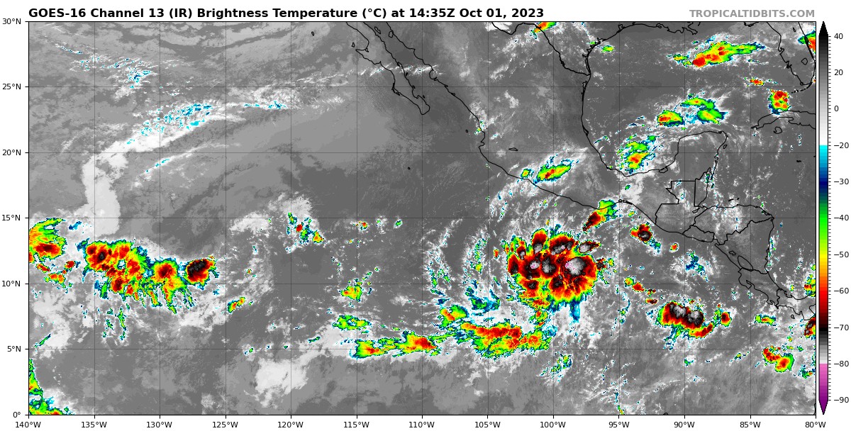
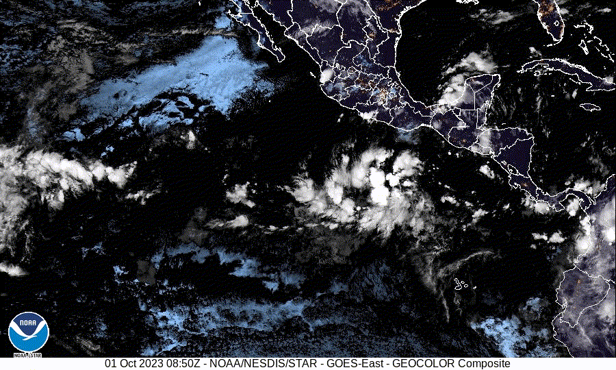
An area of disorganized showers and thunderstorms associated with a
tropical wave is located several hundred miles south of the coast of
southern Mexico. Environmental conditions appear favorable for
gradual development of this system, and a tropical depression is
likely to form during the middle to latter part of next week while
it moves generally northwestward.
* Formation chance through 48 hours...low...20 percent.
* Formation chance through 7 days...high...70 percent.
$$
Forecaster Hogsett/Pasch
0 likes
Visit the Caribbean-Central America Weather Thread where you can find at first post web cams,radars
and observations from Caribbean basin members
Click Here
-
Kingarabian
- S2K Supporter
- Posts: 15462
- Joined: Sat Aug 08, 2009 3:06 am
- Location: Honolulu, Hawaii
#442 Postby Kingarabian » Sat Sep 30, 2023 7:16 pm
Kingarabian wrote:Welp the EPAC seems to have gone dormant.
Soon as I posted this, global models immediately started showing development.
1 likes
RIP Kobe Bryant
-
xtyphooncyclonex
- Category 5
- Posts: 3688
- Age: 22
- Joined: Sat Dec 08, 2012 9:07 am
- Location: Cebu City
-
Contact:
#443 Postby xtyphooncyclonex » Sat Sep 30, 2023 7:57 pm
GFS and the Euro now agree on two pretty strong systems forming. GFS leaning towards two majors. More than enough to take it well above-average.
0 likes
REMINDER: My opinions that I, or any other NON Pro-Met in this forum, are unofficial. Please do not take my opinions as an official forecast and warning. I am NOT a meteorologist. Following my forecasts blindly may lead to false alarm, danger and risk if official forecasts from agencies are ignored.
-
Astromanía
- Category 2
- Posts: 741
- Age: 25
- Joined: Sat Aug 25, 2018 10:34 pm
- Location: Monterrey, N.L, México
#444 Postby Astromanía » Sat Sep 30, 2023 9:03 pm
Hey, I'm going to travel to mazatlan from Oct 8th to 11th, what models says about the potential systems? I know they tend to recurve in Octuber and affect land, I don't want a major in my way lol
0 likes
-
Yellow Evan
- Professional-Met
- Posts: 15960
- Age: 25
- Joined: Fri Jul 15, 2011 12:48 pm
- Location: Henderson, Nevada/Honolulu, HI
-
Contact:
#445 Postby Yellow Evan » Sat Sep 30, 2023 11:41 pm
Potential exists for significant TC activity but not sure if upper environment will cooperate for more potent systems due to the usual easterly shear.
Last edited by
Yellow Evan on Sat Sep 30, 2023 11:46 pm, edited 1 time in total.
0 likes
-
Yellow Evan
- Professional-Met
- Posts: 15960
- Age: 25
- Joined: Fri Jul 15, 2011 12:48 pm
- Location: Henderson, Nevada/Honolulu, HI
-
Contact:
#446 Postby Yellow Evan » Sat Sep 30, 2023 11:45 pm
Astromanía wrote:Hey, I'm going to travel to mazatlan from Oct 8th to 11th, what models says about the potential systems? I know they tend to recurve in Octuber and affect land, I don't want a major in my way lol
Second system is the one to watch that hasn’t been tagged yet that globals and their ensembles still want to recurve.
0 likes
-
cycloneye
- Admin
- Posts: 139604
- Age: 67
- Joined: Thu Oct 10, 2002 10:54 am
- Location: San Juan, Puerto Rico
#447 Postby cycloneye » Sun Oct 01, 2023 6:41 am
Tropical Weather Outlook
NWS National Hurricane Center Miami FL
500 AM PDT Sun Oct 1 2023
For the eastern North Pacific...east of 140 degrees west longitude:
South of Southwestern Mexico:
Shower and thunderstorm activity has increased since yesterday in
association with a tropical wave located several hundred miles south
of the coast of southern Mexico. Environmental conditions are
expected to be favorable for development of this system during the
next several days, and a tropical depression is likely to form
during the middle part of this week while it moves generally
northwestward.
* Formation chance through 48 hours...medium...40 percent.
* Formation chance through 7 days...high...80 percent.
$$
Forecaster Reinhart
0 likes
Visit the Caribbean-Central America Weather Thread where you can find at first post web cams,radars
and observations from Caribbean basin members
Click Here
-
Kingarabian
- S2K Supporter
- Posts: 15462
- Joined: Sat Aug 08, 2009 3:06 am
- Location: Honolulu, Hawaii
#448 Postby Kingarabian » Sun Oct 01, 2023 9:50 am
The GFS has the first system as a big ACE maker cat.4. Euro makes it a cat.1 then kills it quickly. Interests in Mexico should monitor the second system as the global do show a landfalling system and it will be over some of the warmest waters in the Pacific.
0 likes
RIP Kobe Bryant
-
Kingarabian
- S2K Supporter
- Posts: 15462
- Joined: Sat Aug 08, 2009 3:06 am
- Location: Honolulu, Hawaii
#449 Postby Kingarabian » Sun Oct 01, 2023 9:51 am
Theme of the season: Extra large system that takes a little while to get going.
0 likes
RIP Kobe Bryant
-
cycloneye
- Admin
- Posts: 139604
- Age: 67
- Joined: Thu Oct 10, 2002 10:54 am
- Location: San Juan, Puerto Rico
#450 Postby cycloneye » Sun Oct 01, 2023 12:32 pm
The second one added.
Tropical Weather Outlook
NWS National Hurricane Center Miami FL
1100 AM PDT Sun Oct 1 2023
For the eastern North Pacific...east of 140 degrees west longitude:
South of Southwestern Mexico:
A tropical wave located several hundred miles south of the coast of
southern and southwestern Mexico continues to produce a large area
of showers and thunderstorms. Environmental conditions are expected
to be conducive for development of this system during the next
several days, and a tropical depression is expected to form during
the middle part of this week while it moves west-northwestward to
northwestward at about 10 mph.
* Formation chance through 48 hours...medium...50 percent.
* Formation chance through 7 days...high...90 percent.
South of Central America:
A broad area of low pressure could form a few hundred miles south of
the coast of Central America during the middle to latter part of
this week. Thereafter, some gradual development of this system is
possible while it moves slowly westward to west-northwestward.
* Formation chance through 48 hours...low...near 0 percent.
* Formation chance through 7 days...low...20 percent.
$$
Forecaster Reinhart
0 likes
Visit the Caribbean-Central America Weather Thread where you can find at first post web cams,radars
and observations from Caribbean basin members
Click Here
-
cycloneye
- Admin
- Posts: 139604
- Age: 67
- Joined: Thu Oct 10, 2002 10:54 am
- Location: San Juan, Puerto Rico
#452 Postby cycloneye » Sun Oct 01, 2023 1:44 pm
0 likes
Visit the Caribbean-Central America Weather Thread where you can find at first post web cams,radars
and observations from Caribbean basin members
Click Here
-
cycloneye
- Admin
- Posts: 139604
- Age: 67
- Joined: Thu Oct 10, 2002 10:54 am
- Location: San Juan, Puerto Rico
#453 Postby cycloneye » Sun Oct 01, 2023 2:15 pm
GFS and Euro are very bullish on future 99E close to the CA and Mexican coasts. GFS has 954 mbs at landfall while Euro has 969 mbs.
0 likes
Visit the Caribbean-Central America Weather Thread where you can find at first post web cams,radars
and observations from Caribbean basin members
Click Here
-
cycloneye
- Admin
- Posts: 139604
- Age: 67
- Joined: Thu Oct 10, 2002 10:54 am
- Location: San Juan, Puerto Rico
#454 Postby cycloneye » Sun Oct 01, 2023 6:33 pm
South of Central America:
A broad area of low pressure could form a few hundred miles south of
the coast of Central America toward the end of this week.
Thereafter, some gradual development of this system is possible
while it moves slowly westward to west-northwestward.
* Formation chance through 48 hours...low...near 0 percent.
* Formation chance through 7 days...low...30 percent.
Forecaster Roberts
0 likes
Visit the Caribbean-Central America Weather Thread where you can find at first post web cams,radars
and observations from Caribbean basin members
Click Here
-
cycloneye
- Admin
- Posts: 139604
- Age: 67
- Joined: Thu Oct 10, 2002 10:54 am
- Location: San Juan, Puerto Rico
#455 Postby cycloneye » Mon Oct 02, 2023 6:59 am
South of Central America:
An area of low pressure is expected to form a few hundred miles
south of the coast of Central America during the second half of this
week. Environmental conditions are forecast to be favorable for
gradual development of the low pressure system after it forms, and a
tropical depression could develop late this week or over the weekend
while the disturbance moves generally westward to west-northwestward
at around 10 mph.
* Formation chance through 48 hours...low...near 0 percent.
* Formation chance through 7 days...medium...60 percent.
0 likes
Visit the Caribbean-Central America Weather Thread where you can find at first post web cams,radars
and observations from Caribbean basin members
Click Here
-
cycloneye
- Admin
- Posts: 139604
- Age: 67
- Joined: Thu Oct 10, 2002 10:54 am
- Location: San Juan, Puerto Rico
#456 Postby cycloneye » Mon Oct 02, 2023 1:10 pm
South of Central America:
An area of low pressure is expected to form a few hundred miles
south of the coast of Central America during the second half of this
week. Environmental conditions are expected to be favorable for at
least gradual development of the disturbance after it forms, and a
tropical depression could develop late this week or over the weekend
while the system moves slowly westward or west-northwestward.
* Formation chance through 48 hours...low...near 0 percent.
* Formation chance through 7 days...high...70 percent.
0 likes
Visit the Caribbean-Central America Weather Thread where you can find at first post web cams,radars
and observations from Caribbean basin members
Click Here
-
cycloneye
- Admin
- Posts: 139604
- Age: 67
- Joined: Thu Oct 10, 2002 10:54 am
- Location: San Juan, Puerto Rico
#457 Postby cycloneye » Mon Oct 02, 2023 6:53 pm
South of Central America:
An area of low pressure is expected to form a few hundred miles
south of the coast of Central America during the next few days.
Afterward, environmental conditions are expected to be conducive
for gradual development of the disturbance, and a tropical
depression could form late this week or over the weekend while
the system moves slowly westward or west-northwestward.
* Formation chance through 48 hours...low...near 0 percent.
* Formation chance through 7 days...high...70 percent.
0 likes
Visit the Caribbean-Central America Weather Thread where you can find at first post web cams,radars
and observations from Caribbean basin members
Click Here
-
cycloneye
- Admin
- Posts: 139604
- Age: 67
- Joined: Thu Oct 10, 2002 10:54 am
- Location: San Juan, Puerto Rico
#458 Postby cycloneye » Tue Oct 03, 2023 6:58 pm
South of Central America:
An area of low pressure is expected to form a few hundred miles
south of the coast of Central America during the next few days.
Afterward, environmental conditions are expected to be conducive for
gradual development of this system, and a tropical depression is
likely to form late this week or over the weekend while the system
moves slowly westward or west-northwestward.
* Formation chance through 48 hours...low...near 0 percent.
* Formation chance through 7 days...high...70 percent.
0 likes
Visit the Caribbean-Central America Weather Thread where you can find at first post web cams,radars
and observations from Caribbean basin members
Click Here
-
cycloneye
- Admin
- Posts: 139604
- Age: 67
- Joined: Thu Oct 10, 2002 10:54 am
- Location: San Juan, Puerto Rico
#459 Postby cycloneye » Wed Oct 04, 2023 7:28 am
1. South of Central America:
A large area of showers and thunderstorms located well south of the
coast of Guatemala is associated with a trough of low pressure.
Environmental conditions are expected to be conducive for gradual
development during the next several days, and a tropical depression
is likely to form this weekend or early next week while the
disturbance moves slowly west-northwestward.
* Formation chance through 48 hours...low...10 percent.
* Formation chance through 7 days...high...80 percent.
2. Western East Pacific:
An area of low pressure located about 1200 miles southwest of the
southern tip of the Baja California peninsula is producing
disorganized showers and thunderstorms. Development of this system,
if any, should be slow to occur while it moves little during the
next couple of days. By this weekend, environmental conditions are
forecast to become less conducive for further development.
* Formation chance through 48 hours...low...10 percent.
* Formation chance through 7 days...low...10 percent.
0 likes
Visit the Caribbean-Central America Weather Thread where you can find at first post web cams,radars
and observations from Caribbean basin members
Click Here
-
cycloneye
- Admin
- Posts: 139604
- Age: 67
- Joined: Thu Oct 10, 2002 10:54 am
- Location: San Juan, Puerto Rico
#460 Postby cycloneye » Wed Oct 04, 2023 1:18 pm
1. South of Central America:
A large, elongated area of showers and thunderstorms located well
south of the coast of Guatemala is associated with a trough of low
pressure. Environmental conditions are expected to be conducive for
gradual development during the next several days, and a tropical
depression is likely to form this weekend or early next week while
the disturbance moves slowly west-northwestward.
* Formation chance through 48 hours...low...10 percent.
* Formation chance through 7 days...high...80 percent.
2. Western East Pacific:
An area of low pressure located about 1200 miles southwest of the
southern tip of the Baja California peninsula is producing
disorganized showers and thunderstorms. Development of this system,
if any, should be slow to occur while it moves little during the
next couple of days. By this weekend, environmental conditions are
forecast to become less conducive for further development.
* Formation chance through 48 hours...low...10 percent.
* Formation chance through 7 days...low...10 percent.
Forecaster Kelly
0 likes
Visit the Caribbean-Central America Weather Thread where you can find at first post web cams,radars
and observations from Caribbean basin members
Click Here
Return to “Talkin' Tropics”
Who is online
Users browsing this forum: cainjamin, Cpv17, Datsaintsfan09, Google Adsense [Bot], HurakaYoshi, IcyTundra, JaviT, kenayers, KirbyDude25, Landy, lolitx, Old-TimeCane, South Texas Storms, sphelps8681, Stratton23, Tireman4, Wampadawg, weatherSnoop, wwizard and 103 guests