2023 Global Model Runs Discussion (Out thru day 16)

This is the general tropical discussion area. Anyone can take their shot at predicting a storms path.

Moderator: S2k Moderators

Forum rules

The posts in this forum are NOT official forecasts and should not be used as such. They are just the opinion of the poster and may or may not be backed by sound meteorological data. They are NOT endorsed by any professional institution or STORM2K. For official information, please refer to products from the National Hurricane Center and National Weather Service.

Help Support Storm2K
Message
Author
User avatar
WalterWhite
Category 1
Category 1
Posts: 342
Joined: Fri Mar 17, 2023 5:53 pm

Re: 2023 Global Model Runs Discussion (Out thru day 16)

#1481 Postby WalterWhite » Sun Sep 17, 2023 12:33 pm

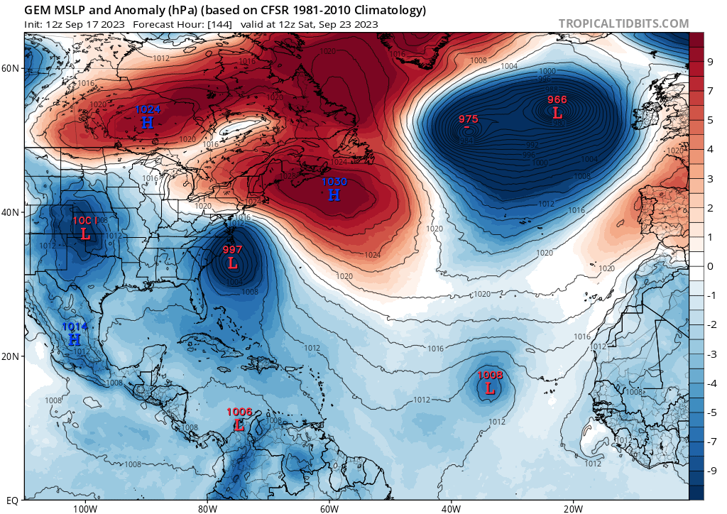
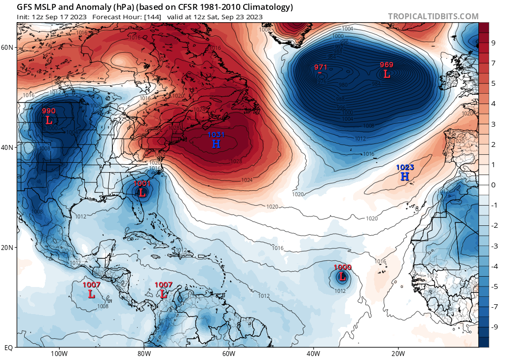
Both the CMC and the GFS show future Ophelia (the area of low pressure near Cape Verde) and future Philippe (the area of low pressure near the Carolinas) forming later this month.

Image

Image
0 likes   

User avatar
AnnularCane
S2K Supporter
S2K Supporter
Posts: 2862
Joined: Thu Jun 08, 2006 9:18 am
Location: Wytheville, VA

Re: 2023 Global Model Runs Discussion (Out thru day 16)

#1482 Postby AnnularCane » Sun Sep 17, 2023 1:21 pm

WalterWhite wrote:Both the CMC and the GFS show future Ophelia (the area of low pressure near Cape Verde) and future Philippe (the area of low pressure near the Carolinas) forming later this month.

https://i.postimg.cc/SK8hF4R0/gem-mslpa-atl-25.png

https://i.postimg.cc/nhXx2Bth/gfs-mslpa-atl-25.png


How do you know the names won't be reversed? :P
0 likes   
"But it never rained rain. It never snowed snow. And it never blew just wind. It rained things like soup and juice. It snowed mashed potatoes and green peas. And sometimes the wind blew in storms of hamburgers." -- Judi Barrett, Cloudy with a Chance of Meatballs

Ianswfl
Category 1
Category 1
Posts: 482
Joined: Thu Mar 23, 2023 11:11 pm

Re: 2023 Global Model Runs Discussion (Out thru day 16)

#1483 Postby Ianswfl » Mon Sep 18, 2023 4:06 pm

The euro ensembles 12z still running but starting to hint at cag season possibly starting soon! Cags are my favorite.
0 likes   

Ianswfl
Category 1
Category 1
Posts: 482
Joined: Thu Mar 23, 2023 11:11 pm

Re: 2023 Global Model Runs Discussion (Out thru day 16)

#1484 Postby Ianswfl » Mon Sep 18, 2023 5:13 pm

Canadian ensembles really kicking cag season into gear early oct with south fl strikes.
0 likes   

Ianswfl
Category 1
Category 1
Posts: 482
Joined: Thu Mar 23, 2023 11:11 pm

Re: 2023 Global Model Runs Discussion (Out thru day 16)

#1485 Postby Ianswfl » Tue Sep 19, 2023 12:57 pm

12z gefs giving off more western Caribbean signals including a SWFL hurricane strike from CAG.
0 likes   

User avatar
chris_fit
Category 5
Category 5
Posts: 3222
Age: 42
Joined: Wed Sep 10, 2003 11:58 pm
Location: Tampa Bay Area, FL

Re: 2023 Global Model Runs Discussion (Out thru day 16)

#1486 Postby chris_fit » Tue Sep 19, 2023 1:12 pm

12Z GFS has something in the Caribbean, turning N through Cuba and out through the Bahamas.


Image
0 likes   

User avatar
SouthFLTropics
Category 5
Category 5
Posts: 4236
Age: 50
Joined: Thu Aug 14, 2003 8:04 am
Location: Port St. Lucie, Florida

Re: 2023 Global Model Runs Discussion (Out thru day 16)

#1487 Postby SouthFLTropics » Tue Sep 19, 2023 2:30 pm

Ianswfl wrote:12z gefs giving off more western Caribbean signals including a SWFL hurricane strike from CAG.

That 12z GEFS is giving off serious 1999 Irene vibes.


Sent from my iPhone using Tapatalk
0 likes   
Fourth Generation Florida Native

Personal Storm History: David 79, Andrew 92, Erin 95, Floyd 99, Irene 99, Frances 04, Jeanne 04, Wilma 05, Matthew 16, Irma 17, Ian 22, Nicole 22, Milton 24

User avatar
Nimbus
Category 5
Category 5
Posts: 5300
Joined: Mon Jul 19, 2004 10:54 am

Re: 2023 Global Model Runs Discussion (Out thru day 16)

#1488 Postby Nimbus » Tue Sep 19, 2023 2:40 pm

Ianswfl wrote:
jlauderdal wrote:We need a seperate thread for SWFL.


Do you think enough signals are there yet for a thread for a possible end of September cag threat though?


The GFS run has the Cuba crossing 10 days out.
Good question though, how many runs do we need to see with the same synoptic (on Storm2k) and do we need to see a model consensus before starting a new thread for a non invest?
0 likes   

Ianswfl
Category 1
Category 1
Posts: 482
Joined: Thu Mar 23, 2023 11:11 pm

Re: 2023 Global Model Runs Discussion (Out thru day 16)

#1489 Postby Ianswfl » Tue Sep 19, 2023 3:03 pm

SouthFLTropics wrote:
Ianswfl wrote:12z gefs giving off more western Caribbean signals including a SWFL hurricane strike from CAG.

That 12z GEFS is giving off serious 1999 Irene vibes.


Sent from my iPhone using Tapatalk


a few other members weaker and further north too. The 368 hr euro ensembles are not out yet, the 240hr one has a bunch of TD members in the carribean. With the pattern this year IMO the OCt and Nov Gulf threats will be Florida storms.
0 likes   

Ianswfl
Category 1
Category 1
Posts: 482
Joined: Thu Mar 23, 2023 11:11 pm

Re: 2023 Global Model Runs Discussion (Out thru day 16)

#1490 Postby Ianswfl » Tue Sep 19, 2023 3:07 pm

The Weathernerds model pages is easier to read but is stuck on hour 288 right now. TT site beyond that has some more members as well. As you can see it looks like the eastern Gulf end of the month the place to watch.

https://www.weathernerds.org/models/gef ... latlon=Off
0 likes   

jlauderdal
S2K Supporter
S2K Supporter
Posts: 7182
Joined: Wed May 19, 2004 5:46 am
Location: NE Fort Lauderdale
Contact:

Re: 2023 Global Model Runs Discussion (Out thru day 16)

#1491 Postby jlauderdal » Tue Sep 19, 2023 3:07 pm

Ianswfl wrote:
SouthFLTropics wrote:
Ianswfl wrote:12z gefs giving off more western Caribbean signals including a SWFL hurricane strike from CAG.

That 12z GEFS is giving off serious 1999 Irene vibes.


Sent from my iPhone using Tapatalk


a few other members weaker and further north too. The 368 hr euro ensembles are not out yet, the 240hr one has a bunch of TD members in the carribean. With the pattern this year IMO the OCt and Nov Gulf threats will be Florida storms.
240 is max we need to go and that is often a bridge to far
0 likes   

Ianswfl
Category 1
Category 1
Posts: 482
Joined: Thu Mar 23, 2023 11:11 pm

Re: 2023 Global Model Runs Discussion (Out thru day 16)

#1492 Postby Ianswfl » Tue Sep 19, 2023 3:28 pm

jlauderdal wrote:
Ianswfl wrote:
SouthFLTropics wrote:That 12z GEFS is giving off serious 1999 Irene vibes.


Sent from my iPhone using Tapatalk


a few other members weaker and further north too. The 368 hr euro ensembles are not out yet, the 240hr one has a bunch of TD members in the carribean. With the pattern this year IMO the OCt and Nov Gulf threats will be Florida storms.
240 is max we need to go and that is often a bridge to far


The GFS keeps shifting the future wave further west. This time over the Bahamas and up and away. The 12z euro is out to sea but much further west than previous runs. Do you think that is one for us to watch in addition to the western Caribbean possible system at the end of sept?

The main difference this year is with the hot Gulf temps could make a stronger system than a typical oct cat2 or cat3 FL usually sees on those tracks. Having water temps around 88 degrees versus 83 degrees like most mid oct years.
0 likes   

User avatar
SouthFLTropics
Category 5
Category 5
Posts: 4236
Age: 50
Joined: Thu Aug 14, 2003 8:04 am
Location: Port St. Lucie, Florida

Re: 2023 Global Model Runs Discussion (Out thru day 16)

#1493 Postby SouthFLTropics » Tue Sep 19, 2023 5:46 pm

jlauderdal wrote:
Ianswfl wrote:
SouthFLTropics wrote:That 12z GEFS is giving off serious 1999 Irene vibes.


Sent from my iPhone using Tapatalk


a few other members weaker and further north too. The 368 hr euro ensembles are not out yet, the 240hr one has a bunch of TD members in the carribean. With the pattern this year IMO the OCt and Nov Gulf threats will be Florida storms.
240 is max we need to go and that is often a bridge to far


This is very true... As always, a long way to go. 18z GFS pattern at 240 is extremely different than the 12z and the 12z was different from 06z and so on and so on. Based on how things have been for quite some time now, the smart money is on a trough being established over the eastern CONUS. Anything that develops in the Eastern Caribbean should get pulled north, up, and out. However, if something waits to spin up in the Western Caribbean, that could be a problem for us in South Florida. What saves us in August and September can hurt us in October. My gut tells me we will see at least one sloppy system spin up out of the Western Caribbean on the tail of a front before the end of October.
0 likes   
Fourth Generation Florida Native

Personal Storm History: David 79, Andrew 92, Erin 95, Floyd 99, Irene 99, Frances 04, Jeanne 04, Wilma 05, Matthew 16, Irma 17, Ian 22, Nicole 22, Milton 24

Ianswfl
Category 1
Category 1
Posts: 482
Joined: Thu Mar 23, 2023 11:11 pm

Re: 2023 Global Model Runs Discussion (Out thru day 16)

#1494 Postby Ianswfl » Tue Sep 19, 2023 7:05 pm

18z gefs has a cat2 into SWFL, a major into the Keys and south FL as well and some weak systems on it. These seem to originate from the Caribbean, not the wave coming off Africa. The cat2 seems to weaken at landfall, likely shear. But that major member into the Keys could be a monster. Not getting pushed back much so I'd say I'd expect stronger signals in future GEFS runs.
2 likes   

User avatar
ThunderForce
Tropical Storm
Tropical Storm
Posts: 208
Age: 25
Joined: Tue Sep 27, 2022 6:20 pm
Location: Calhoun County, Florida

Re: 2023 Global Model Runs Discussion (Out thru day 16)

#1495 Postby ThunderForce » Tue Sep 19, 2023 8:12 pm

Ianswfl wrote:18z gefs has a cat2 into SWFL, a major into the Keys and south FL as well and some weak systems on it. These seem to originate from the Caribbean, not the wave coming off Africa. The cat2 seems to weaken at landfall, likely shear. But that major member into the Keys could be a monster. Not getting pushed back much so I'd say I'd expect stronger signals in future GEFS runs.

For the most part they haven't really shown much development until around the forecast hour 180 mark or later, which is usually about when the operational GFS starts getting into fantasy land and things can shift drastically from run to run. In fact, comparing 18z GEFS to the last run, sub-1000 development has been pushed back to roughly hour 204 whereas the last run (12z) had the first one form at forecast hour 186. The first sub-1000 I've seen in the current 18z GEFS run from that area and not from the current tropical wave pops in at about 06z Thursday. In total, I've counted roughly 3-4 members not related to the current tropical wave that go sub-1000 or so. For comparison, here is the 18z GEFS run from 14th of September compared to the current run.
Image
Image
Overall, the run on the 14th was more actually active than the current one is. This is around the time of season where CAGs start allowing storms to brew more easily in the western Caribbean and Gulf though, so it definitely needs to be watched.
1 likes   
Please refer to the NWS, NHC, SPC or a professional meteorologist for information and decision making during storms.

Ianswfl
Category 1
Category 1
Posts: 482
Joined: Thu Mar 23, 2023 11:11 pm

Re: 2023 Global Model Runs Discussion (Out thru day 16)

#1496 Postby Ianswfl » Tue Sep 19, 2023 8:36 pm

ThunderForce wrote:
Ianswfl wrote:18z gefs has a cat2 into SWFL, a major into the Keys and south FL as well and some weak systems on it. These seem to originate from the Caribbean, not the wave coming off Africa. The cat2 seems to weaken at landfall, likely shear. But that major member into the Keys could be a monster. Not getting pushed back much so I'd say I'd expect stronger signals in future GEFS runs.

For the most part they haven't really shown much development until around the forecast hour 180 mark or later, which is usually about when the operational GFS starts getting into fantasy land and things can shift drastically from run to run. In fact, comparing 18z GEFS to the last run, sub-1000 development has been pushed back to roughly hour 204 whereas the last run (12z) had the first one form at forecast hour 186. The first sub-1000 I've seen in the current 18z GEFS run from that area and not from the current tropical wave pops in at about 06z Thursday. In total, I've counted roughly 3-4 members not related to the current tropical wave that go sub-1000 or so. For comparison, here is the 18z GEFS run from 14th of September compared to the current run.
https://i.imgur.com/gE14ytD.png
https://i.imgur.com/YZ9kOeb.png
Overall, the run on the 14th was more actually active than the current one is. This is around the time of season where CAGs start allowing storms to brew more easily in the western Caribbean and Gulf though, so it definitely needs to be watched.


While the operational gfs shows nothing down there late in the run it does have lower than normal pressures in that area of the basin.

Anything that forms down there could be an eastern gulf threat due to the pattern. I suspect even Nov could be risky. The waters will still be over 80 most likely so if something does get sucked up it could still be strong. Even a mid nov storm sucked up into swfl with upper 70s waters wouldnt have much time to weaken enough if moving fast.

I suspect 10 years from now November will be more like a October for hurricanes due to warmer waters in the Gulf.
1 likes   

User avatar
ThunderForce
Tropical Storm
Tropical Storm
Posts: 208
Age: 25
Joined: Tue Sep 27, 2022 6:20 pm
Location: Calhoun County, Florida

Re: 2023 Global Model Runs Discussion (Out thru day 16)

#1497 Postby ThunderForce » Tue Sep 19, 2023 8:44 pm

Ianswfl wrote:
ThunderForce wrote:
Ianswfl wrote:18z gefs has a cat2 into SWFL, a major into the Keys and south FL as well and some weak systems on it. These seem to originate from the Caribbean, not the wave coming off Africa. The cat2 seems to weaken at landfall, likely shear. But that major member into the Keys could be a monster. Not getting pushed back much so I'd say I'd expect stronger signals in future GEFS runs.

For the most part they haven't really shown much development until around the forecast hour 180 mark or later, which is usually about when the operational GFS starts getting into fantasy land and things can shift drastically from run to run. In fact, comparing 18z GEFS to the last run, sub-1000 development has been pushed back to roughly hour 204 whereas the last run (12z) had the first one form at forecast hour 186. The first sub-1000 I've seen in the current 18z GEFS run from that area and not from the current tropical wave pops in at about 06z Thursday. In total, I've counted roughly 3-4 members not related to the current tropical wave that go sub-1000 or so. For comparison, here is the 18z GEFS run from 14th of September compared to the current run.
https://i.imgur.com/gE14ytD.png
https://i.imgur.com/YZ9kOeb.png
Overall, the run on the 14th was more actually active than the current one is. This is around the time of season where CAGs start allowing storms to brew more easily in the western Caribbean and Gulf though, so it definitely needs to be watched.


While the operational gfs shows nothing down there late in the run it does have lower than normal pressures in that area of the basin.

Anything that forms down there could be an eastern gulf threat due to the pattern. I suspect even Nov could be risky. The waters will still be over 80 most likely so if something does get sucked up it could still be strong. Even a mid nov storm sucked up into swfl with upper 70s waters wouldnt have much time to weaken enough if moving fast.

I suspect 10 years from now November will be more like a October for hurricanes due to warmer waters in the Gulf.

That's the thing though, anything after forecast hour 180/200 on the operational GFS should be taken with a grain of salt because of how wildly things can fluctuate between them. Compare how the current tropical wave storm was way further west before recurving in the last 12z run compared to the current 18z one. The further into the run you get, the less accurate the forecast is. They can be useful for certain data and trends though, of course.

I know how problematic Gulf storms are considering I directly went through Michael back in 2018 and had my entire hometown nearly wiped out. Letting my guard down is the last thing I plan on doing.
0 likes   
Please refer to the NWS, NHC, SPC or a professional meteorologist for information and decision making during storms.

Ianswfl
Category 1
Category 1
Posts: 482
Joined: Thu Mar 23, 2023 11:11 pm

Re: 2023 Global Model Runs Discussion (Out thru day 16)

#1498 Postby Ianswfl » Tue Sep 19, 2023 8:59 pm

ThunderForce wrote:
Ianswfl wrote:
ThunderForce wrote:For the most part they haven't really shown much development until around the forecast hour 180 mark or later, which is usually about when the operational GFS starts getting into fantasy land and things can shift drastically from run to run. In fact, comparing 18z GEFS to the last run, sub-1000 development has been pushed back to roughly hour 204 whereas the last run (12z) had the first one form at forecast hour 186. The first sub-1000 I've seen in the current 18z GEFS run from that area and not from the current tropical wave pops in at about 06z Thursday. In total, I've counted roughly 3-4 members not related to the current tropical wave that go sub-1000 or so. For comparison, here is the 18z GEFS run from 14th of September compared to the current run.
https://i.imgur.com/gE14ytD.png
https://i.imgur.com/YZ9kOeb.png
Overall, the run on the 14th was more actually active than the current one is. This is around the time of season where CAGs start allowing storms to brew more easily in the western Caribbean and Gulf though, so it definitely needs to be watched.


While the operational gfs shows nothing down there late in the run it does have lower than normal pressures in that area of the basin.

Anything that forms down there could be an eastern gulf threat due to the pattern. I suspect even Nov could be risky. The waters will still be over 80 most likely so if something does get sucked up it could still be strong. Even a mid nov storm sucked up into swfl with upper 70s waters wouldnt have much time to weaken enough if moving fast.

I suspect 10 years from now November will be more like a October for hurricanes due to warmer waters in the Gulf.

That's the thing though, anything after forecast hour 180/200 on the operational GFS should be taken with a grain of salt because of how wildly things can fluctuate between them. Compare how the current tropical wave storm was way further west before recurving in the last 12z run compared to the current 18z one. The further into the run you get, the less accurate the forecast is. They can be useful for certain data and trends though, of course.

I know how problematic Gulf storms are considering I directly went through Michael back in 2018 and had my entire hometown nearly wiped out. Letting my guard down is the last thing I plan on doing.


The GFS and ensembles did snuff out Ian and Idalia though long range. Of course landfall points vary each run but they give hints something will form. Seems last year and this year less phantom storms on the models.
0 likes   

IcyTundra
Category 5
Category 5
Posts: 1205
Joined: Mon Jun 07, 2021 9:32 pm
Location: Dickinson, Texas

Re: 2023 Global Model Runs Discussion (Out thru day 16)

#1499 Postby IcyTundra » Tue Sep 19, 2023 9:29 pm

Ianswfl wrote:
ThunderForce wrote:
Ianswfl wrote:
While the operational gfs shows nothing down there late in the run it does have lower than normal pressures in that area of the basin.

Anything that forms down there could be an eastern gulf threat due to the pattern. I suspect even Nov could be risky. The waters will still be over 80 most likely so if something does get sucked up it could still be strong. Even a mid nov storm sucked up into swfl with upper 70s waters wouldnt have much time to weaken enough if moving fast.

I suspect 10 years from now November will be more like a October for hurricanes due to warmer waters in the Gulf.

That's the thing though, anything after forecast hour 180/200 on the operational GFS should be taken with a grain of salt because of how wildly things can fluctuate between them. Compare how the current tropical wave storm was way further west before recurving in the last 12z run compared to the current 18z one. The further into the run you get, the less accurate the forecast is. They can be useful for certain data and trends though, of course.

I know how problematic Gulf storms are considering I directly went through Michael back in 2018 and had my entire hometown nearly wiped out. Letting my guard down is the last thing I plan on doing.


The GFS and ensembles did snuff out Ian and Idalia though long range. Of course landfall points vary each run but they give hints something will form. Seems last year and this year less phantom storms on the models.


Operational GFS performed poorly with the genesis of Idalia compared to the Euro. GFS refused to show Idalia developing until it became clear that there would be development. Can’t remember how the GEFS did.
1 likes   

LarryWx
S2K Supporter
S2K Supporter
Posts: 6305
Joined: Sun Sep 07, 2003 2:04 pm
Location: GA

Re: 2023 Global Model Runs Discussion (Out thru day 16)

#1500 Postby LarryWx » Wed Sep 20, 2023 1:52 pm

12Z Euro says “Ridge Over Troubled Water” part two late next week with a second big (actually stronger) NE US surface high:

https://www.tropicaltidbits.com/analysi ... 012&fh=216
0 likes   
Personal Forecast Disclaimer:
The posts in this forum are NOT official forecasts and should not be used as such. They are just the opinion of the poster and may or may not be backed by sound meteorological data. They are NOT endorsed by any professional institution or storm2k.org. For official information, please refer to the NHC and NWS products.


Return to “Talkin' Tropics”

Who is online

Users browsing this forum: No registered users and 41 guests