ATL: LEE - Post-Tropical - Discussion

Moderator: S2k Moderators

Message
Author
User avatar
Blown Away
S2K Supporter
S2K Supporter
Posts: 10145
Joined: Wed May 26, 2004 6:17 am

Re: ATL: LEE - Tropical Storm - Discussion

#401 Postby Blown Away » Tue Sep 05, 2023 7:36 pm

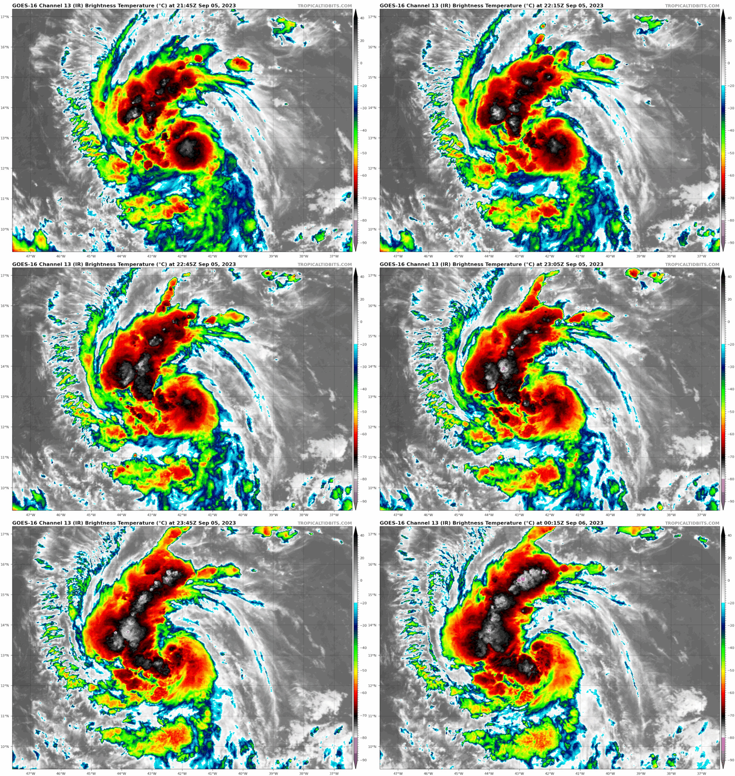
IsabelaWeather wrote:Hard to tell from IR, but I dont really see much, if any, northward movement.

https://imgur.com/a/ZiMlhec

NHC says WNW @ 290* but I am not so sure.
Image

I question the 290* heading too. :double:
0 likes   
Hurricane Eye Experience: David 79, Irene 99, Frances 04, Jeanne 04, Wilma 05... EYE COMING MY WAY IN 2024…
Hurricane Brush Experience: Andrew 92, Erin 95, Floyd 99, Matthew 16, Irma 17, Ian 22, Nicole 22…

User avatar
cycloneye
Admin
Admin
Posts: 145313
Age: 68
Joined: Thu Oct 10, 2002 10:54 am
Location: San Juan, Puerto Rico

Re: ATL: LEE - Tropical Storm - Discussion

#402 Postby cycloneye » Tue Sep 05, 2023 7:38 pm

7 likes   
Visit the Caribbean-Central America Weather Thread where you can find at first post web cams,radars
and observations from Caribbean basin members Click Here

User avatar
cycloneye
Admin
Admin
Posts: 145313
Age: 68
Joined: Thu Oct 10, 2002 10:54 am
Location: San Juan, Puerto Rico

Re: ATL: LEE - Tropical Storm - Discussion

#403 Postby cycloneye » Tue Sep 05, 2023 7:43 pm

Dvorak SAB has 3.5 and is almost a hurricane.

TXNT22 KNES 060020
TCSNTL

A. 13L (LEE)

B. 06/0000Z

C. 13.0N

D. 42.4W

E. THREE/GOES-E

F. T3.5/3.5

G. IR/EIR/SWIR

H. REMARKS...9/10 BANDING RESULTS IN A DT OF 3.5. THE MET IS 3.0 DUE
TO A RAPID DEVELOPMENT TREND OVER 24 HOURS. THE PT IS 3.5. THE FT IS
BASED ON THE DT.

I. ADDL POSITIONS

NIL


...BROWN
2 likes   
Visit the Caribbean-Central America Weather Thread where you can find at first post web cams,radars
and observations from Caribbean basin members Click Here

User avatar
InfernoFlameCat
Category 5
Category 5
Posts: 2102
Age: 22
Joined: Mon Dec 14, 2020 10:52 am
Location: Buford, GA

Re: ATL: LEE - Tropical Storm - Discussion

#404 Postby InfernoFlameCat » Tue Sep 05, 2023 7:46 pm

Lee does sound formidable. It will be a very fun storm to track. Hopefully it looks beautiful. But, on the other hand, very few models show a harmless recurve. This storm will claim lives, even if it goes to sea. Riptides are a real danger that will be especially potent with this storm should it get large enough.
12 likes   
I am by no means a professional. DO NOT look at my forecasts for official information or make decisions based on what I post.

Goal: to become a registered expert over tropical and subtropical cyclones.

User avatar
cycloneye
Admin
Admin
Posts: 145313
Age: 68
Joined: Thu Oct 10, 2002 10:54 am
Location: San Juan, Puerto Rico

Re: ATL: LEE - Tropical Storm - Discussion

#405 Postby cycloneye » Tue Sep 05, 2023 7:51 pm

I thought they would go to 60kts following dvorak.

AL, 13, 2023090600, , BEST, 0, 133N, 424W, 45, 1003, TS
1 likes   
Visit the Caribbean-Central America Weather Thread where you can find at first post web cams,radars
and observations from Caribbean basin members Click Here

User avatar
aspen
Category 5
Category 5
Posts: 8818
Joined: Sat Oct 12, 2019 7:10 pm
Location: Connecticut, USA

Re: ATL: LEE - Tropical Storm - Discussion

#406 Postby aspen » Tue Sep 05, 2023 7:56 pm

cycloneye wrote:I thought they would go to 60kts following dvorak.

AL, 13, 2023090600, , BEST, 0, 133N, 424W, 45, 1003, TS

They may go 5kt higher in the advisory like they did at 5. I doubt this is already a borderline hurricane.
2 likes   
Irene '11 Sandy '12 Hermine '16 5/15/2018 Derecho Fay '20 Isaias '20 Elsa '21 Henri '21 Ida '21

I am only a meteorology enthusiast who knows a decent amount about tropical cyclones. Look to the professional mets, the NHC, or your local weather office for the best information.

CryHavoc
Tropical Storm
Tropical Storm
Posts: 201
Age: 43
Joined: Thu Aug 24, 2017 5:18 pm
Location: Bay Area CA

Re: ATL: LEE - Tropical Storm - Discussion

#407 Postby CryHavoc » Tue Sep 05, 2023 7:59 pm

SconnieCane wrote:
IsabelaWeather wrote:Hard to tell from IR, but I dont really see much, if any, northward movement.

https://imgur.com/a/ZiMlhec

NHC says WNW @ 290* but I am not so sure.


When I click that link it says "This post may contain erotic or adult imagery. By continuing, you acknowledge that you are 18+ years of age."

Not sure if imgur just puts that disclaimer on everything now, or if they've read enough of Josh Morgerman's descriptions of tropical cyclones. :lol:


Weirdest thing, I ran into that on FB today with an image of Jupiter.

These AI algorithms that are designed to detect that stuff are atrocious.

(Sorry for OT)
3 likes   

User avatar
Hurrilurker
Category 2
Category 2
Posts: 719
Joined: Mon Jun 09, 2003 3:32 pm
Location: San Francisco, CA

Re: ATL: LEE - Tropical Storm - Discussion

#408 Postby Hurrilurker » Tue Sep 05, 2023 8:06 pm


Looks like dry air infiltrating toward the core from the NE side?
1 likes   

User avatar
canebeard
Tropical Depression
Tropical Depression
Posts: 98
Joined: Sun Jul 05, 2009 4:06 pm
Contact:

Re: ATL: LEE - Tropical Storm - Discussion

#409 Postby canebeard » Tue Sep 05, 2023 8:11 pm

Lee can be a lady's name, or a man's name.
Not much doubt now which it is.

Image
22 likes   
List of 79 tropical cyclones intercepted by Richard Horodner:
http://www.canebeard.com/page/page/572246.htm
former storm2k screenname Beoumont 2009+

User avatar
ScottNAtlanta
Category 5
Category 5
Posts: 2367
Joined: Sat May 25, 2013 3:11 pm
Location: Atlanta, GA

Re: ATL: LEE - Tropical Storm - Discussion

#410 Postby ScottNAtlanta » Tue Sep 05, 2023 8:13 pm

canebeard wrote:Lee can be a lady's name, or a man's name.
Not much doubt now which it is.

https://i.imgur.com/7wGV3ii.jpg

If it was a lady's name it would be Leigh
4 likes   
The posts in this forum are NOT official forecast and should not be used as such. They are just the opinion of the poster and may or may not be backed by sound meteorological data. They are NOT endorsed by any professional institution or storm2k.org. For official information, please refer to the NHC and NWS products.

User avatar
ScottNAtlanta
Category 5
Category 5
Posts: 2367
Joined: Sat May 25, 2013 3:11 pm
Location: Atlanta, GA

Re: ATL: LEE - Tropical Storm - Discussion

#411 Postby ScottNAtlanta » Tue Sep 05, 2023 8:14 pm

0 likes   
The posts in this forum are NOT official forecast and should not be used as such. They are just the opinion of the poster and may or may not be backed by sound meteorological data. They are NOT endorsed by any professional institution or storm2k.org. For official information, please refer to the NHC and NWS products.

IsabelaWeather
Category 1
Category 1
Posts: 287
Age: 35
Joined: Tue Jul 07, 2020 7:29 am
Location: Isabela, Puerto Rico

Re: ATL: LEE - Tropical Storm - Discussion

#412 Postby IsabelaWeather » Tue Sep 05, 2023 8:15 pm

Why do people think that band is an issue? Looks like a large inflow convergence band to me.

Does the inflow band need to be on the SE side of the storm to help it? Or can it be the mirror opposite as well?
1 likes   

User avatar
Emmett_Brown
Category 5
Category 5
Posts: 1432
Joined: Wed Aug 24, 2005 9:10 pm
Location: Sarasota FL

Re: ATL: LEE - Tropical Storm - Discussion

#413 Postby Emmett_Brown » Tue Sep 05, 2023 8:23 pm

IsabelaWeather wrote:Why do people think that band is an issue? Looks like a large inflow convergence band to me.

Does the inflow band need to be on the SE side of the storm to help it? Or can it be the mirror opposite as well?


Not sure, but sometimes when large lobes of convection form outside the area of the formative core, it is because of moist air colliding with dry air. So it may mean that dry air could be entrained into the core at some point as it organizes, but that's just a guess. However, I have heard just as many comments that this "shrimp" like appearance portends rapid organization.
1 likes   

User avatar
Meteorcane
Category 2
Category 2
Posts: 559
Joined: Thu Jul 21, 2011 6:49 am
Location: North Platte Nebraska

Re: ATL: LEE - Tropical Storm - Discussion

#414 Postby Meteorcane » Tue Sep 05, 2023 8:34 pm

Emmett_Brown wrote:
IsabelaWeather wrote:Why do people think that band is an issue? Looks like a large inflow convergence band to me.

Does the inflow band need to be on the SE side of the storm to help it? Or can it be the mirror opposite as well?


Not sure, but sometimes when large lobes of convection form outside the area of the formative core, it is because of moist air colliding with dry air. So it may mean that dry air could be entrained into the core at some point as it organizes, but that's just a guess. However, I have heard just as many comments that this "shrimp" like appearance portends rapid organization.


Yeah, definitely in drier mid-lvl environments, peripheral convection can generate stable outflows (which propagate inwards toward the TC center) which inhibit the ability of convection to form near the core. In more moist environments though, peripheral convection can actually help moisten and pre-condition the environment surrounding the TC and actually enhance the development of near core convection.

Outside of the moisture component, strong outer bands can sometimes inhibit the overall system upper-lvl outflow (thus inhibiting the deepening of the low-lvl vortex). That being said, any issues Lee has with ventilation will likely be solved in the next day or two as the upper-lvl pattern becomes very conducive for it, with at least 3 clear outflow channels devleoping.
4 likes   

Ianswfl
Category 1
Category 1
Posts: 482
Joined: Thu Mar 23, 2023 11:11 pm

Re: ATL: LEE - Tropical Storm - Discussion

#415 Postby Ianswfl » Tue Sep 05, 2023 8:40 pm


18z euro and the 18z euro ensembles shifted south yet again. Watch the NHC cone shift south naturally and people around here will start freaking out buying supplies just because the cone is pointed towards FL even though it's not even near it yet.
0 likes   

User avatar
cycloneye
Admin
Admin
Posts: 145313
Age: 68
Joined: Thu Oct 10, 2002 10:54 am
Location: San Juan, Puerto Rico

Re: ATL: LEE - Tropical Storm - Discussion

#416 Postby cycloneye » Tue Sep 05, 2023 8:55 pm

2 likes   
Visit the Caribbean-Central America Weather Thread where you can find at first post web cams,radars
and observations from Caribbean basin members Click Here

mantis83
Tropical Storm
Tropical Storm
Posts: 198
Joined: Fri Dec 05, 2003 4:47 pm

Re: ATL: LEE - Tropical Storm - Discussion

#417 Postby mantis83 » Tue Sep 05, 2023 9:01 pm


could be a best case scenario if that happened
0 likes   

CryHavoc
Tropical Storm
Tropical Storm
Posts: 201
Age: 43
Joined: Thu Aug 24, 2017 5:18 pm
Location: Bay Area CA

Re: ATL: LEE - Tropical Storm - Discussion

#418 Postby CryHavoc » Tue Sep 05, 2023 9:04 pm

1 likes   

Sciencerocks
Category 5
Category 5
Posts: 9155
Age: 39
Joined: Thu Jul 06, 2017 1:51 am

Re: ATL: LEE - Tropical Storm - Discussion

#419 Postby Sciencerocks » Tue Sep 05, 2023 9:13 pm

Image
0 likes   

Craters
Category 1
Category 1
Posts: 421
Joined: Sat Aug 24, 2013 2:34 pm
Location: Alvin, TX (south of Houston)

Re: ATL: LEE - Tropical Storm - Discussion

#420 Postby Craters » Tue Sep 05, 2023 9:16 pm

ScottNAtlanta wrote:
canebeard wrote:Lee can be a lady's name, or a man's name.
Not much doubt now which it is.

https://i.imgur.com/7wGV3ii.jpg

If it was a lady's name it would be Leigh


Not necessarily. Catwoman (in the original TV Batman series) was played by Lee Meriwether...
2 likes   
Nothing that I post here should ever be treated as a forecast or anything resembling one. Please check with your local NWS office or the NHC for forecasts, watches, and warnings.


Return to “2023”

Who is online

Users browsing this forum: No registered users and 5 guests