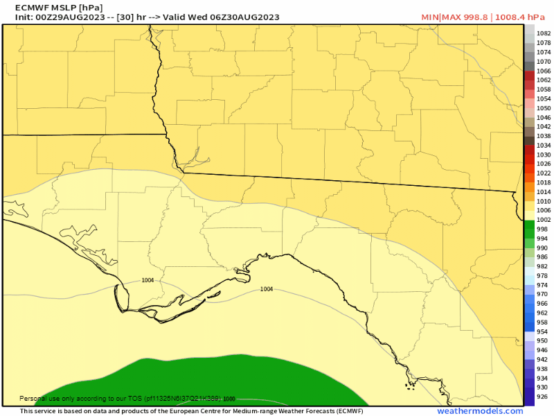
12z ICON
ATL: IDALIA - Models
Moderator: S2k Moderators
-
Blown Away

- S2K Supporter

- Posts: 10253
- Joined: Wed May 26, 2004 6:17 am
Re: ATL: IDALIA - Models
12z ICON
1 likes
Hurricane Eye Experience: David 79, Irene 99, Frances 04, Jeanne 04, Wilma 05… Hurricane Brush Experience: Andrew 92, Erin 95, Floyd 99, Matthew 16, Irma 17, Ian 22, Nicole 22…
Re: ATL: IDALIA - Models
The ICON is trying to form another low in the Gulf on Idalias tail on the 12z??
0 likes
-
tolakram
- Admin

- Posts: 20178
- Age: 62
- Joined: Sun Aug 27, 2006 8:23 pm
- Location: Florence, KY (name is Mark)
Re: ATL: IDALIA - Models
HAFS-A

HAFS-B

HAFS-B
0 likes
M a r k
- - - - -
Join us in chat: Storm2K Chatroom Invite. Android and IOS apps also available.
The posts in this forum are NOT official forecasts and should not be used as such. Posts are NOT endorsed by any professional institution or STORM2K.org. For official information and forecasts, please refer to NHC and NWS products.
-
tolakram
- Admin
- Posts: 20178
- Age: 62
- Joined: Sun Aug 27, 2006 8:23 pm
- Location: Florence, KY (name is Mark)
Re: ATL: IDALIA - Models
HWRF

0 likes
M a r k
- - - - -
Join us in chat: Storm2K Chatroom Invite. Android and IOS apps also available.
The posts in this forum are NOT official forecasts and should not be used as such. Posts are NOT endorsed by any professional institution or STORM2K.org. For official information and forecasts, please refer to NHC and NWS products.
- - - - -
Join us in chat: Storm2K Chatroom Invite. Android and IOS apps also available.
The posts in this forum are NOT official forecasts and should not be used as such. Posts are NOT endorsed by any professional institution or STORM2K.org. For official information and forecasts, please refer to NHC and NWS products.
-
tolakram
- Admin
- Posts: 20178
- Age: 62
- Joined: Sun Aug 27, 2006 8:23 pm
- Location: Florence, KY (name is Mark)
Re: ATL: IDALIA - Models
HMON

0 likes
M a r k
- - - - -
Join us in chat: Storm2K Chatroom Invite. Android and IOS apps also available.
The posts in this forum are NOT official forecasts and should not be used as such. Posts are NOT endorsed by any professional institution or STORM2K.org. For official information and forecasts, please refer to NHC and NWS products.
- - - - -
Join us in chat: Storm2K Chatroom Invite. Android and IOS apps also available.
The posts in this forum are NOT official forecasts and should not be used as such. Posts are NOT endorsed by any professional institution or STORM2K.org. For official information and forecasts, please refer to NHC and NWS products.
-
tolakram
- Admin
- Posts: 20178
- Age: 62
- Joined: Sun Aug 27, 2006 8:23 pm
- Location: Florence, KY (name is Mark)
Re: ATL: IDALIA - Models
12Z UKMET

1 likes
M a r k
- - - - -
Join us in chat: Storm2K Chatroom Invite. Android and IOS apps also available.
The posts in this forum are NOT official forecasts and should not be used as such. Posts are NOT endorsed by any professional institution or STORM2K.org. For official information and forecasts, please refer to NHC and NWS products.
- - - - -
Join us in chat: Storm2K Chatroom Invite. Android and IOS apps also available.
The posts in this forum are NOT official forecasts and should not be used as such. Posts are NOT endorsed by any professional institution or STORM2K.org. For official information and forecasts, please refer to NHC and NWS products.

-
USTropics
- Professional-Met

- Posts: 2737
- Joined: Sun Aug 12, 2007 3:45 am
- Location: Florida State University
Re: ATL: IDALIA - Models
USTropics wrote:
It's very subtle, but notice the extension of ridging over northern Cuba at 200mb on the GFS, this nudges Idalia every so subtly to the NW during this timeframe:
https://i.imgur.com/KhvCpAU.png
This feature does not exist on the 12z ECMWF operational at the same timeframe:
https://i.imgur.com/jqVXbgb.png
While it'll be easy to call the GFS solution crazy, I would caution against that. The 12z ECMWF ensembles had split camps on this scenario, so the GFS solution is definitely not out of the realm of possibility:
https://i.imgur.com/PZ76reI.png
The difference is likely due to how the operational models handle Franklin. A stronger (and more westward) Franklin on the GFS vs ECMWF appears to create this extension of ridging through adiabatic processes.
In the end, it appears the GFS solution ended up verifying closer to reality. This is a lesson in why recency bias (how one models performs compared to another in a specific situation) and which model is "better" is not a useful way to use these tools.
3 likes
-
Blown Away
- S2K Supporter
- Posts: 10253
- Joined: Wed May 26, 2004 6:17 am
Re: ATL: IDALIA - Models
12z EURO
0 likes
Hurricane Eye Experience: David 79, Irene 99, Frances 04, Jeanne 04, Wilma 05… Hurricane Brush Experience: Andrew 92, Erin 95, Floyd 99, Matthew 16, Irma 17, Ian 22, Nicole 22…
-
cycloneye

- Admin
- Posts: 149275
- Age: 69
- Joined: Thu Oct 10, 2002 10:54 am
- Location: San Juan, Puerto Rico
Re: ATL: IDALIA - Models
0 likes
Visit the Caribbean-Central America Weather Thread where you can find at first post web cams,radars
and observations from Caribbean basin members Click Here
and observations from Caribbean basin members Click Here
-
Hypercane_Kyle

- Category 5

- Posts: 3465
- Joined: Sat Mar 07, 2015 7:58 pm
- Location: Cape Canaveral, FL
Re: ATL: IDALIA - Models
Just to appreciate how quickly Idalia is going to ramp up tonight:
The 12z GFS initialized the storm at 989mb, about 10mb too high. Even considering that, the GFS drops the central pressure down to <957mb before landfall tomorrow morning.
The 12z GFS initialized the storm at 989mb, about 10mb too high. Even considering that, the GFS drops the central pressure down to <957mb before landfall tomorrow morning.
0 likes
My posts are my own personal opinion, defer to the National Hurricane Center (NHC) and other NOAA products for decision making during hurricane season.
-
tolakram
- Admin
- Posts: 20178
- Age: 62
- Joined: Sun Aug 27, 2006 8:23 pm
- Location: Florence, KY (name is Mark)
Re: ATL: IDALIA - Models
12Z Euro

0 likes
M a r k
- - - - -
Join us in chat: Storm2K Chatroom Invite. Android and IOS apps also available.
The posts in this forum are NOT official forecasts and should not be used as such. Posts are NOT endorsed by any professional institution or STORM2K.org. For official information and forecasts, please refer to NHC and NWS products.
- - - - -
Join us in chat: Storm2K Chatroom Invite. Android and IOS apps also available.
The posts in this forum are NOT official forecasts and should not be used as such. Posts are NOT endorsed by any professional institution or STORM2K.org. For official information and forecasts, please refer to NHC and NWS products.
-
Hurricaneman

- Category 5
- Posts: 7404
- Age: 45
- Joined: Tue Aug 31, 2004 3:24 pm
- Location: central florida
Re: ATL: IDALIA - Models
My feeling looking at the global models and their ensembles this could very well be a problem again for Florida sometime next week as some of them loop back, something to keep an eye on
0 likes
-
Bluehawk
- Tropical Low

- Posts: 33
- Joined: Wed Sep 27, 2017 10:29 pm
- Location: Boca Raton, Palm Beach County, FL
Re: ATL: IDALIA - Models
Hurricaneman wrote:My feeling looking at the global models and their ensembles this could very well be a problem again for Florida sometime next week as some of them loop back, something to keep an eye on
Hello! I have only posted a few times throughout the years, but I am always following this forum with a mix of gratitude, fascination, and desire to learn. We live in PB, so, for now, we are praying for whoever is in Idalia's path to be safe. I too was wondering about the models showing her returning for a "take two"—this time on the East Coast. I started seeing such posts on this forum since yesterday, I want to say, but, of course, I realize many things can change. What would be the time frame for that eventuality? And with what strength? Once again, I am beyond grateful for all the wealth of information to be found here!
3 likes
-
Blown Away
- S2K Supporter
- Posts: 10253
- Joined: Wed May 26, 2004 6:17 am
Re: ATL: IDALIA - Models
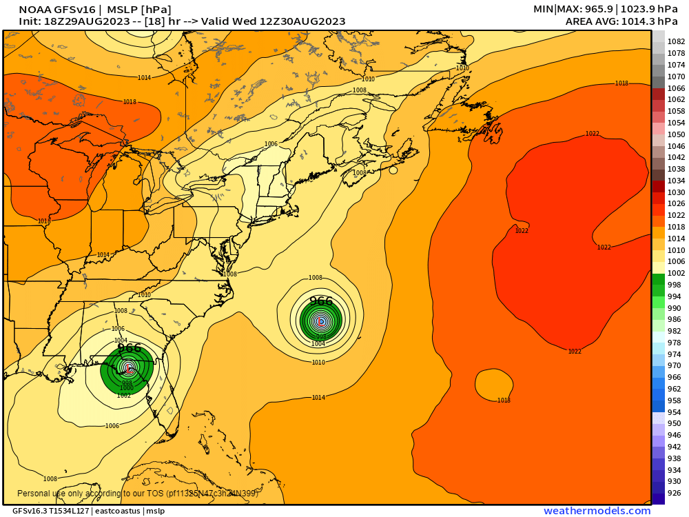
18z GFS... Slight E shift and pressure up 8mb to 966 compared to 12z
0 likes
Hurricane Eye Experience: David 79, Irene 99, Frances 04, Jeanne 04, Wilma 05… Hurricane Brush Experience: Andrew 92, Erin 95, Floyd 99, Matthew 16, Irma 17, Ian 22, Nicole 22…
Re: ATL: IDALIA - Models
Hurricane Donna in the 60’s headed for Jacksonville and did a complete turnaround and hit Miami. I know because I was 8 years old and got to play in the eye.
Also Wilma did a turnaround in October and hit Miami to the shock of the citizenry.
Also Wilma did a turnaround in October and hit Miami to the shock of the citizenry.
1 likes

Re: ATL: IDALIA - Models
Blown Away wrote:[url]https://i.postimg.cc/dtVVmQk3/GFS-Pressure-Lev-3h-MSLP-MSLP-18.png [/url]
18z GFS... Slight E shift and pressure up 8mb to 966 compared to 12z
now that's a graphic you don't see everyday!
0 likes
-
jlauderdal
- S2K Supporter
- Posts: 7240
- Joined: Wed May 19, 2004 5:46 am
- Location: NE Fort Lauderdale
- Contact:
Re: RE: Re: ATL: IDALIA - Models
2 weeks ago, all was quiet on the western atlantic frontjdjaguar wrote:Blown Away wrote:[url]https://i.postimg.cc/dtVVmQk3/GFS-Pressure-Lev-3h-MSLP-MSLP-18.png [/url]
18z GFS... Slight E shift and pressure up 8mb to 966 compared to 12z
now that's a graphic you don't see everyday!
1 likes
-
skillz305
- Category 1

- Posts: 312
- Joined: Sat Sep 08, 2018 11:10 am
- Location: Miami, Florida --> Vero Beach, Florida
Re: ATL: IDALIA - Models
When you realize the GFS and some others sniffed all this out happening in the gulf with a decent Hurricane chance, well over a week ago in some of Franklins south of DR/Haiti runs *mindblown*. Give the models some credit. 
3 likes
 Hurricanes: Andrew 1992 - Irene 1999 - Frances 2004 - Jeanne 2004 - Katrina 2005 - Wilma 2005 - Matthew 2016 - Irma 2017 - Ian 2022 - Nicole 2022 - Milton 2024
Re: ATL: IDALIA - Models
skillz305 wrote:When you realize the GFS and some others sniffed all this out happening in the gulf with a decent Hurricane chance, well over a week ago in some of Franklins south of DR/Haiti runs *mindblown*. Give the models some credit.
The GFS post on the first page of this thread has landfall extremely close to that predicted on last page of this thread.
That doesn't happen often!
1 likes
I'm not a meteorologist, I'm an electronics engineer. While I can probably fix your toaster oven, you're not going to learn about storms from me!
New Mexico had no hurricanes. Then I moved to NC right before Fran.....
New Mexico had no hurricanes. Then I moved to NC right before Fran.....
Who is online
Users browsing this forum: No registered users and 29 guests