

ATL: FRANKLIN - Post-Tropical - Discussion
Moderator: S2k Moderators
-
Sciencerocks
- Category 5

- Posts: 10180
- Age: 39
- Joined: Thu Jul 06, 2017 1:51 am

-
ElectricStorm

- Category 5
- Posts: 5124
- Age: 24
- Joined: Tue Aug 13, 2019 11:23 pm
- Location: Norman, OK
Re: ATL: FRANKLIN - Hurricane - Discussion
Looks like recon is about to make its first pass. Looks like there could be a bit of dry air trying to get in there, I'm guessing recon will find a similar intensity to the last mission
Edit: extrap pressure 975 so looks like I've been proved wrong in about 10 seconds
Edit: extrap pressure 975 so looks like I've been proved wrong in about 10 seconds
0 likes
B.S Meteorology, University of Oklahoma '25
Please refer to the NHC, NWS, or SPC for official information.
Please refer to the NHC, NWS, or SPC for official information.

Re: ATL: FRANKLIN - Hurricane - Discussion
ElectricStorm wrote:Looks like recon is about to make its first pass. Looks like there could be a bit of dry air trying to get in there, I'm guessing recon will find a similar intensity to the last mission
Edit: extrap pressure 975 so looks like I've been proved wrong in about 10 seconds
I’m guessing the pressure is catching up to the winds, which so far seem lower than last flight. But they haven’t sampled the NE quad yet.
0 likes
Irene '11 Sandy '12 Hermine '16 5/15/2018 Derecho Fay '20 Isaias '20 Elsa '21 Henri '21 Ida '21
I am only a meteorology enthusiast who knows a decent amount about tropical cyclones. Look to the professional mets, the NHC, or your local weather office for the best information.
I am only a meteorology enthusiast who knows a decent amount about tropical cyclones. Look to the professional mets, the NHC, or your local weather office for the best information.


-
Sciencerocks
- Category 5
- Posts: 10180
- Age: 39
- Joined: Thu Jul 06, 2017 1:51 am

-
cycloneye

- Admin

- Posts: 148835
- Age: 69
- Joined: Thu Oct 10, 2002 10:54 am
- Location: San Juan, Puerto Rico
Re: ATL: FRANKLIN - Hurricane - Discussion
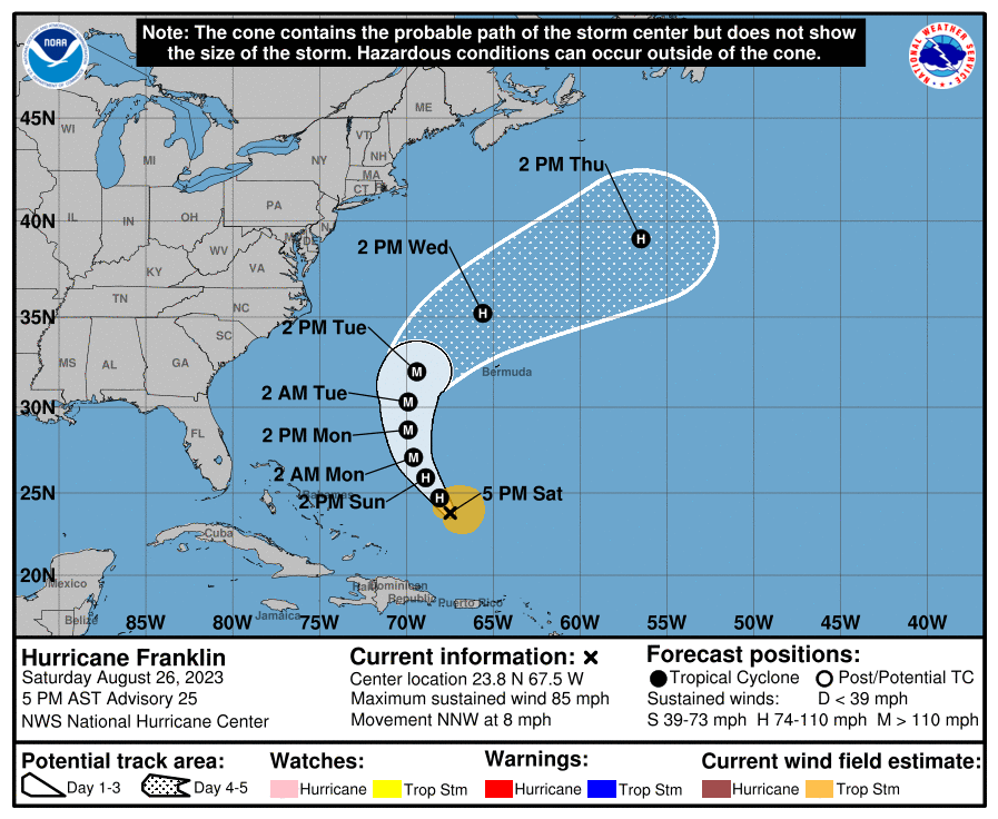
AL, 08, 2023082700, , BEST, 0, 239N, 679W, 75, 976, HU
0 likes
Visit the Caribbean-Central America Weather Thread where you can find at first post web cams,radars
and observations from Caribbean basin members Click Here
and observations from Caribbean basin members Click Here
Re: ATL: FRANKLIN - Hurricane - Discussion
Pressure has dropped a lot, however winds are not picking up.
1 likes
-
ScottNAtlanta

- Category 5
- Posts: 2535
- Joined: Sat May 25, 2013 3:11 pm
- Location: Atlanta, GA
Re: ATL: FRANKLIN - Hurricane - Discussion
zzzh wrote:Pressure has dropped a lot, however winds are not picking up.
75kts was the highest surface wind I saw. Looks like they missed the center on the dropsonde since it had 55kts at splashdown (AF plane)
0 likes
The posts in this forum are NOT official forecast and should not be used as such. They are just the opinion of the poster and may or may not be backed by sound meteorological data. They are NOT endorsed by any professional institution or storm2k.org. For official information, please refer to the NHC and NWS products.
-
Sciencerocks
- Category 5
- Posts: 10180
- Age: 39
- Joined: Thu Jul 06, 2017 1:51 am


Re: ATL: FRANKLIN - Hurricane - Discussion
I would not be surprised if Franklin becomes a major hurricane by tomorrow.
1 likes

Re: ATL: FRANKLIN - Hurricane - Discussion
Is Franklin's inflow (from the s.w.) drawing energy from #10? Weakening #10?
0 likes
Re: ATL: FRANKLIN - Hurricane - Discussion
NHC now forecasting Franklin to become a cat 4 with 130 mph winds at peak intensity.
3 likes
-
Sciencerocks
- Category 5
- Posts: 10180
- Age: 39
- Joined: Thu Jul 06, 2017 1:51 am

-
ScottNAtlanta
- Category 5
- Posts: 2535
- Joined: Sat May 25, 2013 3:11 pm
- Location: Atlanta, GA
Re: ATL: FRANKLIN - Hurricane - Discussion
There has been very little northward component to Franklin's motion in the last 6 hours. It isn't forecast to cross 70w until Monday at 2am. I believe it is going to cross that by sunrise. Looking at the water vapor loop, the trough that is supposed to steer it out is fairly flat right now, and the further west this gets, the more it looks like it might miss the trough
0 likes
The posts in this forum are NOT official forecast and should not be used as such. They are just the opinion of the poster and may or may not be backed by sound meteorological data. They are NOT endorsed by any professional institution or storm2k.org. For official information, please refer to the NHC and NWS products.

Re: ATL: FRANKLIN - Hurricane - Discussion
0 likes
TC naming lists: retirements and intensity
Most aggressive Advisory #1's in North Atlantic (cr. kevin for starting the list)
Most aggressive Advisory #1's in North Atlantic (cr. kevin for starting the list)
Re: ATL: FRANKLIN - Hurricane - Discussion
Recon is about to fly into Franklin. Will it find a Cat 2 or a steady high-end Cat 1?
0 likes
Irene '11 Sandy '12 Hermine '16 5/15/2018 Derecho Fay '20 Isaias '20 Elsa '21 Henri '21 Ida '21
I am only a meteorology enthusiast who knows a decent amount about tropical cyclones. Look to the professional mets, the NHC, or your local weather office for the best information.
I am only a meteorology enthusiast who knows a decent amount about tropical cyclones. Look to the professional mets, the NHC, or your local weather office for the best information.
-
weeniepatrol

- Category 5
- Posts: 1339
- Joined: Sat Aug 22, 2020 5:30 pm
- Location: WA State

-
Hurricane2022

- Category 5
- Posts: 1993
- Joined: Tue Aug 23, 2022 11:38 pm
- Location: Araçatuba, Brazil
Re: ATL: FRANKLIN - Hurricane - Discussion
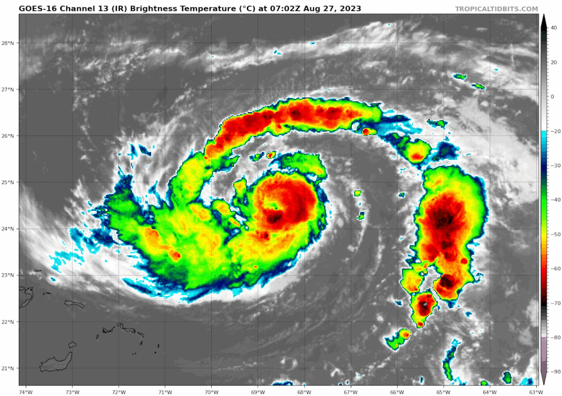
000
URNT12 KNHC 271312
VORTEX DATA MESSAGE AL082023
A. 27/12:51:30Z
B. 24.99 deg N 069.15 deg W
C. 700 mb 2870 m
D. 972 mb
E. 200 deg 6 kt
F. CLOSED
G. C20
H. 66 kt
I. 320 deg 9 nm 12:48:30Z
J. 051 deg 66 kt
K. 319 deg 11 nm 12:48:00Z
L. 62 kt
M. 139 deg 8 nm 12:54:00Z
N. 233 deg 63 kt
O. 137 deg 10 nm 12:54:30Z
P. 12 C / 3042 m
Q. 16 C / 3048 m
R. 4 C / NA
S. 12345 / 07
T. 0.02 / 1 nm
U. AF300 1308A FRANKLIN OB 10
MAX FL WIND 84 KT 046 / 13 NM 11:20:30Z
CONCENTRIC BAND FORMING AROUND EYEWALL, ~70NM DIAMETER
;
Last edited by Hurricane2022 on Sun Aug 27, 2023 8:23 am, edited 1 time in total.
0 likes
Sorry for the bad English sometimes...!
For reliable and detailed information for any meteorological phenomenon, please consult the National Hurricane Center, Joint Typhoon Warning Center , or your local Meteo Center.
--------
ECCE OMNIA NOVA FACIAM (Ap 21,5).
For reliable and detailed information for any meteorological phenomenon, please consult the National Hurricane Center, Joint Typhoon Warning Center , or your local Meteo Center.
--------
ECCE OMNIA NOVA FACIAM (Ap 21,5).
-
cycloneye
- Admin
- Posts: 148835
- Age: 69
- Joined: Thu Oct 10, 2002 10:54 am
- Location: San Juan, Puerto Rico
Re: ATL: FRANKLIN - Hurricane - Discussion
0 likes
Visit the Caribbean-Central America Weather Thread where you can find at first post web cams,radars
and observations from Caribbean basin members Click Here
and observations from Caribbean basin members Click Here
Who is online
Users browsing this forum: No registered users and 33 guests