
ATL: IDALIA - Models
Moderator: S2k Moderators
-
tolakram
- Admin

- Posts: 20179
- Age: 62
- Joined: Sun Aug 27, 2006 8:23 pm
- Location: Florence, KY (name is Mark)
Re: ATL: TEN - Models
1 likes
M a r k
- - - - -
Join us in chat: Storm2K Chatroom Invite. Android and IOS apps also available.
The posts in this forum are NOT official forecasts and should not be used as such. Posts are NOT endorsed by any professional institution or STORM2K.org. For official information and forecasts, please refer to NHC and NWS products.
-
Blown Away

- S2K Supporter

- Posts: 10253
- Joined: Wed May 26, 2004 6:17 am
Re: ATL: TEN - Models
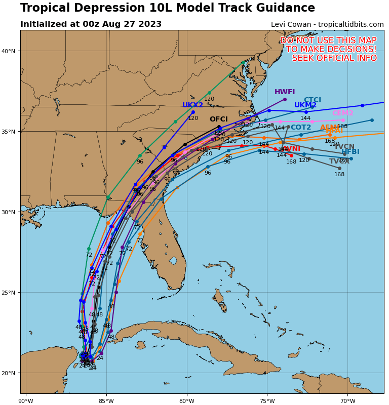
tolakram wrote:https://i.imgur.com/WAc9eIj.png
I can’t imagine what Cedar Key and Steinhatchee would look like if this happened.
2 likes
Hurricane Eye Experience: David 79, Irene 99, Frances 04, Jeanne 04, Wilma 05… Hurricane Brush Experience: Andrew 92, Erin 95, Floyd 99, Matthew 16, Irma 17, Ian 22, Nicole 22…

Re: ATL: TEN - Models
tolakram wrote:https://i.imgur.com/ipdohf8.png
Another east shift by the HWRF. The Hafs models big shift too. Mroe shifts, and SWFL will be in the cone too.
1 likes
-
toad strangler

- S2K Supporter
- Posts: 4546
- Joined: Sun Jul 28, 2013 3:09 pm
- Location: Earth
- Contact:
Re: ATL: TEN - Models
johngaltfla wrote:toad strangler wrote:Category5Kaiju wrote:
I actually had to blink twice to make sure that wasn't a mistake. As in, the animation you shared wasn't that of Ian from last year.
Kind of hard to believe the Gulf Coast of Florida's peninsula is under the gun yet again with another I storm.
I don’t think it’s hard to believe at all. It’s that sweet spot zone of barreling towards peak season in a climatological area bursting with historic activity. The name thing is secondary. I is in a favorable spot in the alphabet to be up to bat in prime season. That’s all probability…. Not anything sinister.
We actually live for this. Because this insanity will not end until they fix the GFS.
In the mean time, back to model talk, I really want to see what happens after the 0600 data tomorrow gets added to the mix. I have a feeling everything changes dramatically between 0800-1200 ET as the flight data holds the key.
“Fix the GFS”?
What does that even mean? Every model has its bright spots, bias, and flaws. The GFS with all its perceived problems isn’t at the bottom half of recent verification scores. Posted earlier today by another member.
2 likes
My Weather Station
https://www.wunderground.com/dashboard/pws/KFLPORTS603
https://www.wunderground.com/dashboard/pws/KFLPORTS603

Re: ATL: TEN - Models
that looks like Ft meyers bound. Let’s hope not
0 likes
Robbielyn McCrary
I know just about enough to sound like I know what I'm talking about sometimes. But for your safety please follow the nhc for truly professional forecasting.
I know just about enough to sound like I know what I'm talking about sometimes. But for your safety please follow the nhc for truly professional forecasting.
-
hohnywx
- Category 2

- Posts: 511
- Age: 34
- Joined: Sun Jul 19, 2009 8:34 pm
- Location: Hastings-on-Hudson, NY
Re: ATL: TEN - Models
GTStorm wrote:
What's the story with the HAFS model…is it fairly new? Reliable? Seems to be a track model..is it related to HWRF?
NOAA put them into service in June 2023 to eventually replace the HWRF and HMON - https://www.noaa.gov/news-release/noaa- ... rts-strong
2 likes
-
chris_fit

- Category 5

- Posts: 3261
- Age: 43
- Joined: Wed Sep 10, 2003 11:58 pm
- Location: Tampa Bay Area, FL
Re: ATL: TEN - Models
18z EPS... Eyeballing it but looks like the mean will be a decent W shift?
0 likes
Re: ATL: TEN - Models
robbielyn wrote:
that looks like Ft meyers bound. Let’s hope not
More like Bradenton. I doubt the approach is as sharp as Charley this time.
0 likes
-
tolakram
- Admin
- Posts: 20179
- Age: 62
- Joined: Sun Aug 27, 2006 8:23 pm
- Location: Florence, KY (name is Mark)
Re: ATL: TEN - Models
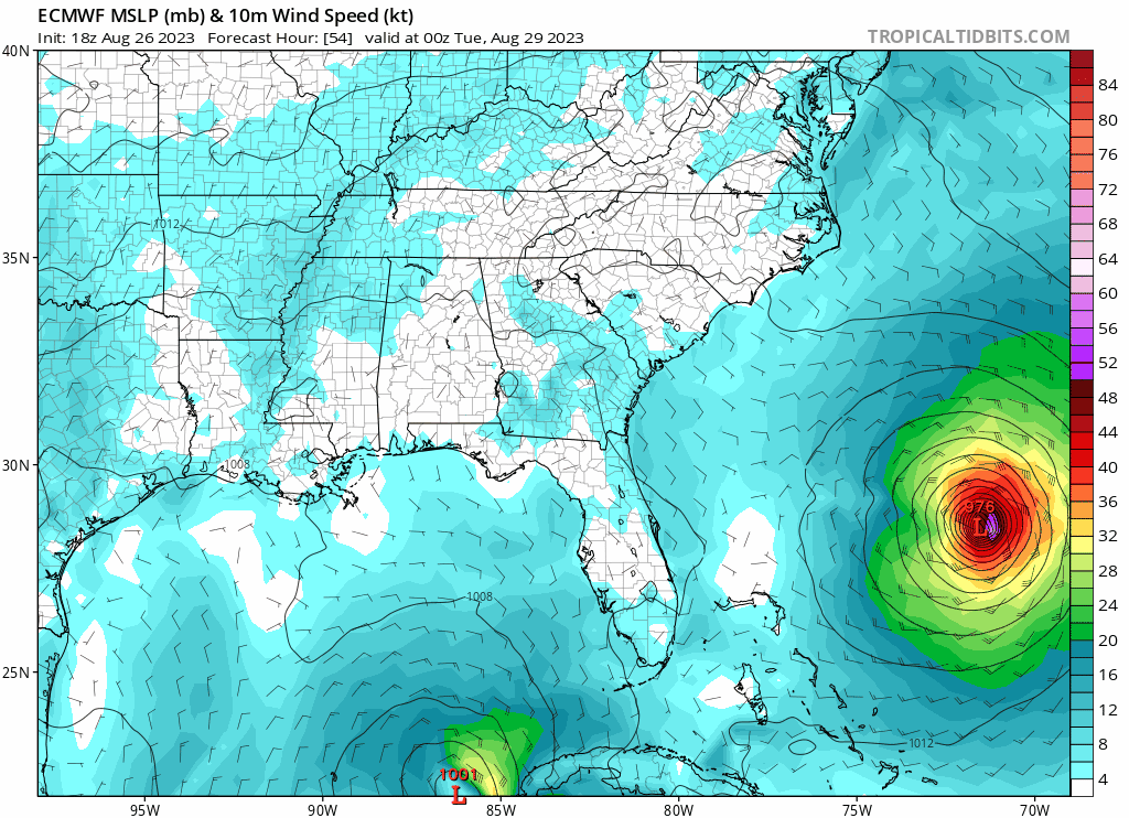
18Z Euro

0 likes
M a r k
- - - - -
Join us in chat: Storm2K Chatroom Invite. Android and IOS apps also available.
The posts in this forum are NOT official forecasts and should not be used as such. Posts are NOT endorsed by any professional institution or STORM2K.org. For official information and forecasts, please refer to NHC and NWS products.
- - - - -
Join us in chat: Storm2K Chatroom Invite. Android and IOS apps also available.
The posts in this forum are NOT official forecasts and should not be used as such. Posts are NOT endorsed by any professional institution or STORM2K.org. For official information and forecasts, please refer to NHC and NWS products.
Re: ATL: TEN - Models
0 likes
-
gatorcane

- S2K Supporter
- Posts: 23708
- Age: 48
- Joined: Sun Mar 13, 2005 3:54 pm
- Location: Boca Raton, FL
Re: ATL: TEN - Models
18Z Euro loop. Looks like it shifted slightly east and a bit faster. With Tampa area, west-central Florida on dirty side and with SW onshore winds, would see some decent impacts and you wonder if the storm would be stronger than what the Euro is modeling:
1 likes
-
Spacecoast

- Category 2
- Posts: 773
- Joined: Thu Aug 31, 2017 2:03 pm

-
tolakram
- Admin
- Posts: 20179
- Age: 62
- Joined: Sun Aug 27, 2006 8:23 pm
- Location: Florence, KY (name is Mark)
Re: ATL: TEN - Models
Interesting that stronger runs are both left and right of the main track estimate.
1 likes
M a r k
- - - - -
Join us in chat: Storm2K Chatroom Invite. Android and IOS apps also available.
The posts in this forum are NOT official forecasts and should not be used as such. Posts are NOT endorsed by any professional institution or STORM2K.org. For official information and forecasts, please refer to NHC and NWS products.
- - - - -
Join us in chat: Storm2K Chatroom Invite. Android and IOS apps also available.
The posts in this forum are NOT official forecasts and should not be used as such. Posts are NOT endorsed by any professional institution or STORM2K.org. For official information and forecasts, please refer to NHC and NWS products.
Re: ATL: TEN - Models
tolakram wrote:Interesting that stronger runs are both left and right of the main track estimate.
A cat2 member right up tampa bay and now a couple into ft. Myers area and one way south. Ddint see that on 12z
0 likes
Re: ATL: TEN - Models
Ianswfl wrote:tolakram wrote:https://i.imgur.com/ipdohf8.png
Another east shift by the HWRF. The Hafs models big shift too. Mroe shifts, and SWFL will be in the cone too.
Yeah, Accuweather cone includes SWFL.
0 likes
Cleo - 1964, Betsy - 1965, David - 1979, Andrew - 1992, Charlie (Francis, Ivan, Jeanne) - 2004, Irma - 2017, Ian - 2022, Milton - 2024
-
jlauderdal
- S2K Supporter
- Posts: 7240
- Joined: Wed May 19, 2004 5:46 am
- Location: NE Fort Lauderdale
- Contact:
Re: RE: Re: ATL: TEN - Models
The lack of real movement is a drag on model performance for sure.Ianswfl wrote:tolakram wrote:Interesting that stronger runs are both left and right of the main track estimate.
A cat2 member right up tampa bay and now a couple into ft. Myers area and one way south. Ddint see that on 12z
1 likes
Re: RE: Re: ATL: TEN - Models
jlauderdal wrote:The lack of real movement is a drag on model performance for sure.Ianswfl wrote:tolakram wrote:Interesting that stronger runs are both left and right of the main track estimate.
A cat2 member right up tampa bay and now a couple into ft. Myers area and one way south. Ddint see that on 12z
Don't they use the data from the highs/lows/trofs, ect. moving in upper atmosphere to calculate its movements? May not be ideal for intensification, but I would think it would be simpler to forecast movement based on air currents.
0 likes
Cleo - 1964, Betsy - 1965, David - 1979, Andrew - 1992, Charlie (Francis, Ivan, Jeanne) - 2004, Irma - 2017, Ian - 2022, Milton - 2024
-
Spacecoast
- Category 2
- Posts: 773
- Joined: Thu Aug 31, 2017 2:03 pm
Re: ATL: TEN - Models
According to the18z EPS, the next 48hr will determine how far E, or W it will eventually take.
A SW dive, looping clockwise into Yucatan, or a SE dive looping counterclockwise towards Cuba....

A SW dive, looping clockwise into Yucatan, or a SE dive looping counterclockwise towards Cuba....
1 likes
Who is online
Users browsing this forum: No registered users and 25 guests