
ATL: IDALIA - Models
Moderator: S2k Moderators
Re: ATL: TEN - Models
18z Canadian (last frame) compared to 12z 2mb stronger and slightly right.
0 likes
-
jlauderdal
- S2K Supporter

- Posts: 7240
- Joined: Wed May 19, 2004 5:46 am
- Location: NE Fort Lauderdale
- Contact:
Re: RE: Re: ATL: TEN - Models
The gfs has been terrible with this system and that continues until proven otherwise...a few days ago the nhc completly blew off its solution of no system and started probabilitieschaser1 wrote:So, just a thought. GFS showing only a 5 mb drop in pressure in 60 hr's? Given the significant amout of organization that occured today and assuming no near term land interaction then i'm not sure what mitigating factor would prevent moderate deepening resulting faster pressure falls (especially given the bath water below). Upwelling? Misalligned LLC/MLC? Increase in shear? A stronger storm at 60 hr's. then what the GFS is depicting "may" impact the further downstream GFS forecast.
1 likes
Re: ATL: TEN - Models
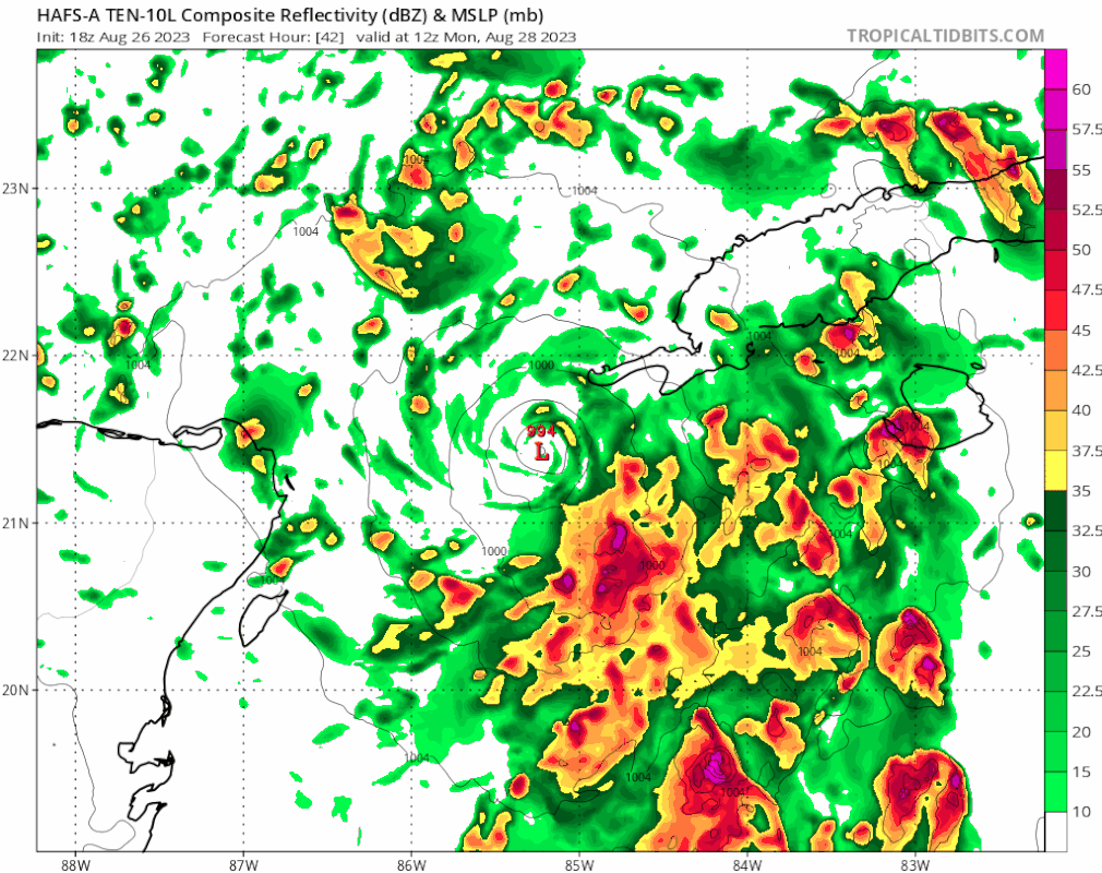
Hurricane models are coming in (To monday).
still around Yucatan
HMON has it cat 2 by monday morning.
HAFS A/B has it cat 1.
still around Yucatan
HMON has it cat 2 by monday morning.
HAFS A/B has it cat 1.
0 likes
-
gatorcane

- S2K Supporter
- Posts: 23704
- Age: 47
- Joined: Sun Mar 13, 2005 3:54 pm
- Location: Boca Raton, FL
Re: ATL: TEN - Models
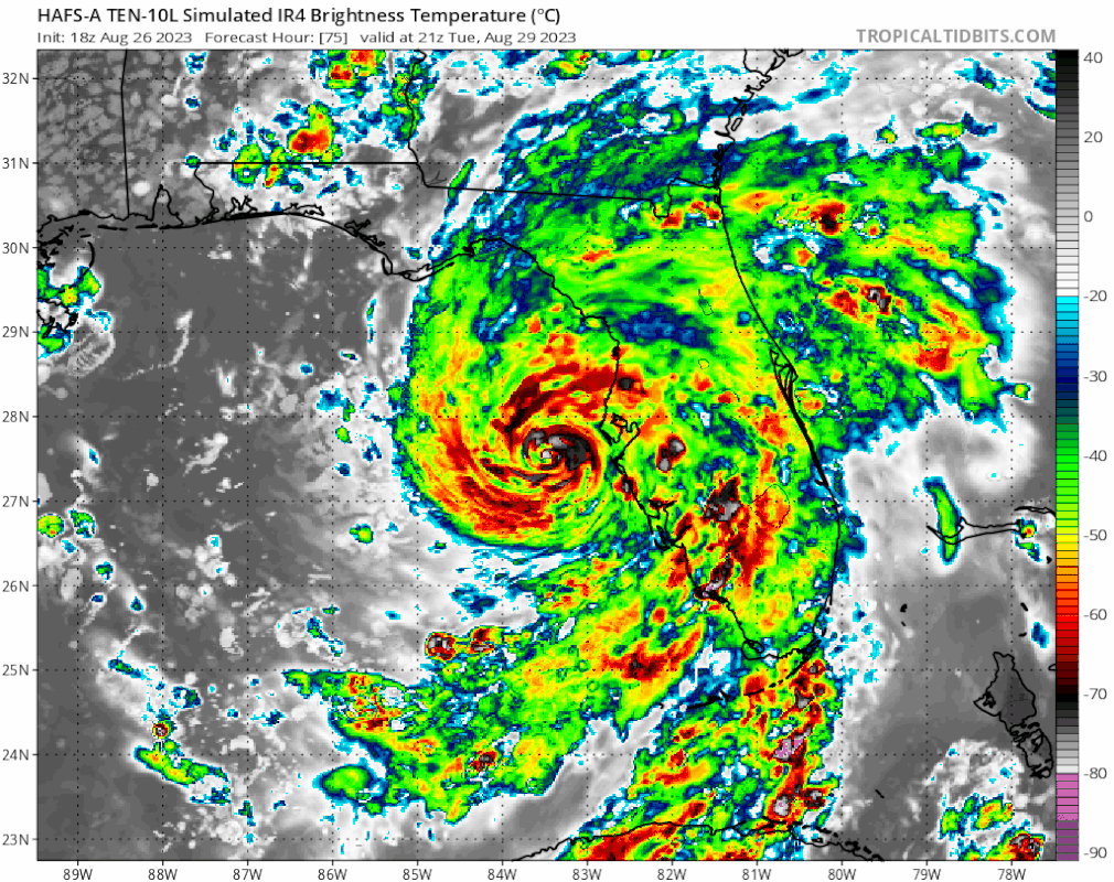
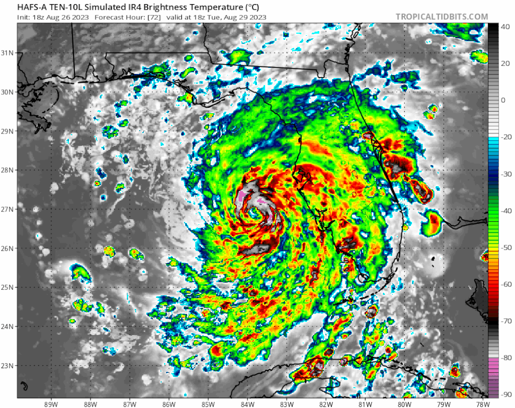
Huge shift east by HAFS-A. Looks to be heading close to the Tampa area:
2 likes
-
gatorcane
- S2K Supporter
- Posts: 23704
- Age: 47
- Joined: Sun Mar 13, 2005 3:54 pm
- Location: Boca Raton, FL
Re: ATL: TEN - Models
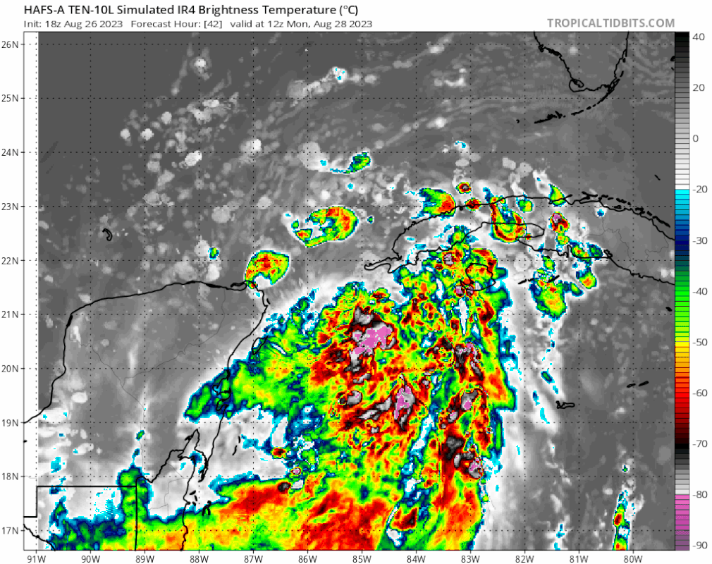
Here is the simulated IR from HAFS-A. No bueno for surge-prone Tampa area and west coast of Florida 
1 likes
-
SFLcane

- S2K Supporter
- Posts: 10281
- Age: 48
- Joined: Sat Jun 05, 2010 1:44 pm
- Location: Lake Worth Florida
Re: ATL: TEN - Models
Right turn? This model did great with Ian
https://twitter.com/ericburriswesh/status/1695551215759687852
https://twitter.com/ericburriswesh/status/1695551215759687852
1 likes
-
Category5Kaiju

- Category 5

- Posts: 4317
- Joined: Thu Dec 24, 2020 12:45 pm
- Location: Seattle and Phoenix
Re: ATL: TEN - Models
SFLcane wrote:Right turn? This model did great with Ian
https://twitter.com/ericburriswesh/status/1695551215759687852?s=46&t=sStb56JhzYdUjITqDzKFmQ
I actually had to blink twice to make sure that wasn't a mistake. As in, the animation you shared wasn't that of Ian from last year.
Kind of hard to believe the Gulf Coast of Florida's peninsula is under the gun yet again with another I storm.
2 likes
Unless explicitly stated, all info in my posts is based on my own opinions and observations. Tropical storms and hurricanes can be extremely dangerous. Refer to an accredited weather research agency or meteorologist if you need to make serious decisions regarding an approaching storm.
-
PavelGaborik10
- Category 1

- Posts: 472
- Joined: Tue Sep 04, 2018 3:23 pm
Re: ATL: TEN - Models
Certainly still not ideal but worth pointing out that those are gusts, not sustained winds.
1 likes
-
SFLcane
- S2K Supporter
- Posts: 10281
- Age: 48
- Joined: Sat Jun 05, 2010 1:44 pm
- Location: Lake Worth Florida
Re: ATL: TEN - Models
SFLcane wrote:Right turn? This model did great with Ian
https://twitter.com/ericburriswesh/status/1695551215759687852?s=46&t=sStb56JhzYdUjITqDzKFmQ
If that is a a right turn that’s pretty concerning.
1 likes
-
SFLcane
- S2K Supporter
- Posts: 10281
- Age: 48
- Joined: Sat Jun 05, 2010 1:44 pm
- Location: Lake Worth Florida
Re: ATL: TEN - Models
Category5Kaiju wrote:SFLcane wrote:Right turn? This model did great with Ian
https://twitter.com/ericburriswesh/status/1695551215759687852?s=46&t=sStb56JhzYdUjITqDzKFmQ
I actually had to blink twice to make sure that wasn't a mistake. As in, the animation you shared wasn't that of Ian from last year.
Kind of hard to believe the Gulf Coast of Florida's peninsula is under the gun yet again with another I storm.
Ian? Nope that’s TD10
0 likes

-
SFLcane
- S2K Supporter
- Posts: 10281
- Age: 48
- Joined: Sat Jun 05, 2010 1:44 pm
- Location: Lake Worth Florida
Re: ATL: TEN - Models
Trended east again…
Last edited by SFLcane on Sat Aug 26, 2023 6:54 pm, edited 1 time in total.
1 likes
-
tolakram
- Admin

- Posts: 20170
- Age: 62
- Joined: Sun Aug 27, 2006 8:23 pm
- Location: Florence, KY (name is Mark)
Re: ATL: TEN - Models
HWRF going all in on the far east track.

0 likes
M a r k
- - - - -
Join us in chat: Storm2K Chatroom Invite. Android and IOS apps also available.
The posts in this forum are NOT official forecasts and should not be used as such. Posts are NOT endorsed by any professional institution or STORM2K.org. For official information and forecasts, please refer to NHC and NWS products.
-
tolakram
- Admin
- Posts: 20170
- Age: 62
- Joined: Sun Aug 27, 2006 8:23 pm
- Location: Florence, KY (name is Mark)
Re: ATL: TEN - Models
HAFS-A

B

B
1 likes
M a r k
- - - - -
Join us in chat: Storm2K Chatroom Invite. Android and IOS apps also available.
The posts in this forum are NOT official forecasts and should not be used as such. Posts are NOT endorsed by any professional institution or STORM2K.org. For official information and forecasts, please refer to NHC and NWS products.
- - - - -
Join us in chat: Storm2K Chatroom Invite. Android and IOS apps also available.
The posts in this forum are NOT official forecasts and should not be used as such. Posts are NOT endorsed by any professional institution or STORM2K.org. For official information and forecasts, please refer to NHC and NWS products.
-
toad strangler

- S2K Supporter
- Posts: 4546
- Joined: Sun Jul 28, 2013 3:09 pm
- Location: Earth
- Contact:
Re: ATL: TEN - Models
Category5Kaiju wrote:SFLcane wrote:Right turn? This model did great with Ian
https://twitter.com/ericburriswesh/status/1695551215759687852?s=46&t=sStb56JhzYdUjITqDzKFmQ
I actually had to blink twice to make sure that wasn't a mistake. As in, the animation you shared wasn't that of Ian from last year.
Kind of hard to believe the Gulf Coast of Florida's peninsula is under the gun yet again with another I storm.
I don’t think it’s hard to believe at all. It’s that sweet spot zone of barreling towards peak season in a climatological area bursting with historic activity. The name thing is secondary. I is in a favorable spot in the alphabet to be up to bat in prime season. That’s all probability…. Not anything sinister.
7 likes
My Weather Station
https://www.wunderground.com/dashboard/pws/KFLPORTS603
https://www.wunderground.com/dashboard/pws/KFLPORTS603
-
tolakram
- Admin
- Posts: 20170
- Age: 62
- Joined: Sun Aug 27, 2006 8:23 pm
- Location: Florence, KY (name is Mark)
Re: ATL: TEN - Models

0 likes
M a r k
- - - - -
Join us in chat: Storm2K Chatroom Invite. Android and IOS apps also available.
The posts in this forum are NOT official forecasts and should not be used as such. Posts are NOT endorsed by any professional institution or STORM2K.org. For official information and forecasts, please refer to NHC and NWS products.
- - - - -
Join us in chat: Storm2K Chatroom Invite. Android and IOS apps also available.
The posts in this forum are NOT official forecasts and should not be used as such. Posts are NOT endorsed by any professional institution or STORM2K.org. For official information and forecasts, please refer to NHC and NWS products.
-
johngaltfla

- Category 5
- Posts: 2073
- Joined: Sun Jul 10, 2005 9:17 pm
- Location: Sarasota County, FL
- Contact:
Re: ATL: TEN - Models
toad strangler wrote:Category5Kaiju wrote:SFLcane wrote:Right turn? This model did great with Ian
https://twitter.com/ericburriswesh/status/1695551215759687852?s=46&t=sStb56JhzYdUjITqDzKFmQ
I actually had to blink twice to make sure that wasn't a mistake. As in, the animation you shared wasn't that of Ian from last year.
Kind of hard to believe the Gulf Coast of Florida's peninsula is under the gun yet again with another I storm.
I don’t think it’s hard to believe at all. It’s that sweet spot zone of barreling towards peak season in a climatological area bursting with historic activity. The name thing is secondary. I is in a favorable spot in the alphabet to be up to bat in prime season. That’s all probability…. Not anything sinister.
We actually live for this. Because this insanity will not end until they fix the GFS.
In the mean time, back to model talk, I really want to see what happens after the 0600 data tomorrow gets added to the mix. I have a feeling everything changes dramatically between 0800-1200 ET as the flight data holds the key.
0 likes
-
SFLcane
- S2K Supporter
- Posts: 10281
- Age: 48
- Joined: Sat Jun 05, 2010 1:44 pm
- Location: Lake Worth Florida
Re: ATL: TEN - Models
johngaltfla wrote:toad strangler wrote:Category5Kaiju wrote:
I actually had to blink twice to make sure that wasn't a mistake. As in, the animation you shared wasn't that of Ian from last year.
Kind of hard to believe the Gulf Coast of Florida's peninsula is under the gun yet again with another I storm.
I don’t think it’s hard to believe at all. It’s that sweet spot zone of barreling towards peak season in a climatological area bursting with historic activity. The name thing is secondary. I is in a favorable spot in the alphabet to be up to bat in prime season. That’s all probability…. Not anything sinister.
We actually live for this. Because this insanity will not end until they fix the GFS.
In the mean time, back to model talk, I really want to see what happens after the 0600 data tomorrow gets added to the mix. I have a feeling everything changes dramatically between 0800-1200 ET as the flight data holds the key.
+1
1 likes

Re: ATL: TEN - Models
What's the story with the HAFS model…is it fairly new? Reliable? Seems to be a track model..is it related to HWRF?
0 likes
Who is online
Users browsing this forum: No registered users and 13 guests