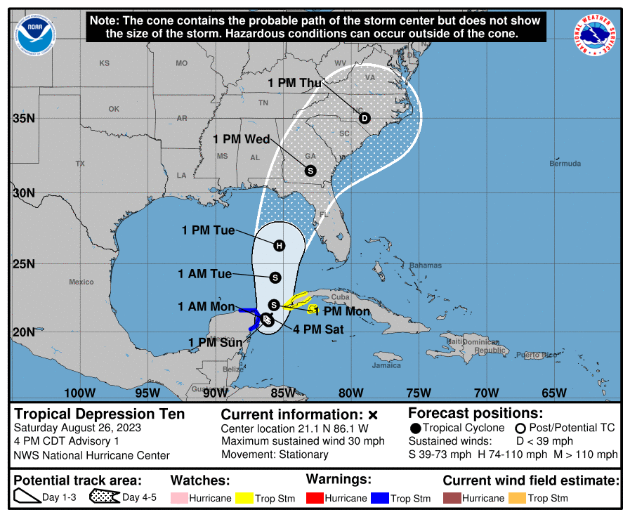
ATL: IDALIA - Post-Tropical - Discussion

Moderator: S2k Moderators

Message
Author
User avatar
ConvergenceZone
Category 5
Category 5
Posts: 5194
Joined: Fri Jul 29, 2005 1:40 am
Location: Northern California

Re: ATL: TEN - Tropical Depression - Discussion

#421 Postby ConvergenceZone » Sat Aug 26, 2023 4:46 pm

ElectricStorm wrote:
ConvergenceZone wrote:
SconnieCane wrote:
They go with 65 kts at the 72-hour forecast point, which is at about the latitude of Fort Myers. Plenty of water between there and landfall.


Now that I re-read it, I think they are calling for 65 knots at PEAK though, so I'm assuming that means that they expect shear much more after that. If they aren't calling for 65 knots at peak, feel free to correct me. But then again I guess there isn't much difference between a 65 MPH or a 75 mph at landfall.

They don't mention increasing shear after that
The tropical cyclone will be moving over very warm waters with only
moderate vertical wind shear anticipated during the next several
days. Therefore, gradual strengthening is forecast. The official
forecast is similar to the latest LGEM guidance and shows the
system becoming a hurricane over the eastern Gulf of Mexico. Users
are reminded that there is significant uncertainty in 3-4 day
intensity predictions and are urged to monitor changes to future
forecasts.


We'll see what the hurricane models have for the 18z runs but the last cycle all showed it strengthening all the way up to landfall. Considering how much space is between the 65kt point and land I would imagine it would probably get a little stronger than that.

That being said it's still a bit far out to know what exactly will happen. The first step is avoiding any land interaction with the Yucatan or Cuba like the current NHC track has. If it can do that I think it opens the door for a stronger system later in the gulf.


Guess I"m just going with Met Wxman said, which is a very sheared system at landfall. There is also no indication that the expected Shear suppose to abate at all...
0 likes   

tolakram
Admin
Admin
Posts: 20009
Age: 62
Joined: Sun Aug 27, 2006 8:23 pm
Location: Florence, KY (name is Mark)

Re: ATL: TEN - Tropical Depression - Discussion

#422 Postby tolakram » Sat Aug 26, 2023 4:54 pm

saved loop Image
3 likes   
M a r k
- - - - -
Join us in chat: Storm2K Chatroom Invite. Android and IOS apps also available.

The posts in this forum are NOT official forecasts and should not be used as such. Posts are NOT endorsed by any professional institution or STORM2K.org. For official information and forecasts, please refer to NHC and NWS products.

Keldeo1997
Category 2
Category 2
Posts: 637
Joined: Fri Oct 11, 2019 11:35 pm

Re: ATL: TEN - Tropical Depression - Discussion

#423 Postby Keldeo1997 » Sat Aug 26, 2023 4:56 pm

2 likes   

Keldeo1997
Category 2
Category 2
Posts: 637
Joined: Fri Oct 11, 2019 11:35 pm

Re: ATL: TEN - Tropical Depression - Discussion

#424 Postby Keldeo1997 » Sat Aug 26, 2023 5:12 pm

2 likes   

User avatar
REDHurricane
Category 1
Category 1
Posts: 396
Age: 27
Joined: Sun Jul 03, 2022 2:36 pm
Location: Northeast Pacific Ocean

Re: ATL: TEN - Tropical Depression - Discussion

#425 Postby REDHurricane » Sat Aug 26, 2023 5:17 pm

Image
2 likes   

jlauderdal
S2K Supporter
S2K Supporter
Posts: 7183
Joined: Wed May 19, 2004 5:46 am
Location: NE Fort Lauderdale
Contact:

Re: RE: Re: ATL: TEN - Tropical Depression - Discussion

#426 Postby jlauderdal » Sat Aug 26, 2023 5:21 pm

Blown Away wrote:
gatorcane wrote:First track. From around Bradenton to Destin:

https://i.postimg.cc/HshVDykY/205449-5day-cone-no-line-and-wind.png


That’s a very rare hurricane track into the Big Bend arm pit. Just like with Ian, I’ll play the big odds that doesn’t happen. JMHO
Where do you think its going?
1 likes   

Stormlover1970
Tropical Low
Tropical Low
Posts: 32
Age: 55
Joined: Sun May 22, 2022 9:26 am
Location: New Port Richey, Florida

Re: RE: Re: ATL: TEN - Tropical Depression - Discussion

#427 Postby Stormlover1970 » Sat Aug 26, 2023 5:41 pm

jlauderdal wrote:
Blown Away wrote:
gatorcane wrote:First track. From around Bradenton to Destin:

https://i.postimg.cc/HshVDykY/205449-5day-cone-no-line-and-wind.png


That’s a very rare hurricane track into the Big Bend arm pit. Just like with Ian, I’ll play the big odds that doesn’t happen. JMHO
Where do you think it’s going?
We will know better with recon
0 likes   

floridasun
Tropical Storm
Tropical Storm
Posts: 201
Joined: Tue Sep 14, 2021 3:59 pm

Re: ATL: TEN - Tropical Depression - Discussion

#428 Postby floridasun » Sat Aug 26, 2023 5:46 pm


will nhc move center that area and will that change track anyway?
0 likes   

User avatar
robbielyn
Category 5
Category 5
Posts: 1298
Joined: Wed May 07, 2003 9:45 am
Location: brooksville, fl

Re: ATL: TEN - Tropical Depression - Discussion

#429 Postby robbielyn » Sat Aug 26, 2023 5:51 pm

check out Levi Cowan’s YT video that just came out. He’s talking possible strong hurricane only possible impediment dry air.
4 likes   
Robbielyn McCrary
I know just about enough to sound like I know what I'm talking about sometimes. But for your safety please follow the nhc for truly professional forecasting. :D

TomballEd
Category 2
Category 2
Posts: 695
Age: 61
Joined: Wed Aug 16, 2023 4:52 pm
Location: Spring/Klein area, not Tomball

Re: ATL: TEN - Tropical Depression - Discussion

#430 Postby TomballEd » Sat Aug 26, 2023 5:55 pm

GFS (Tropical Tidbits 700-300 mb mid level humidity) hour 90 seems to imply dry air as it nears Florida should keep TD 10 from becoming 'too' strong.
0 likes   

User avatar
Blown Away
S2K Supporter
S2K Supporter
Posts: 10145
Joined: Wed May 26, 2004 6:17 am

Re: RE: Re: ATL: TEN - Tropical Depression - Discussion

#431 Postby Blown Away » Sat Aug 26, 2023 5:56 pm

jlauderdal wrote:
Blown Away wrote:
gatorcane wrote:First track. From around Bradenton to Destin:

https://i.postimg.cc/HshVDykY/205449-5day-cone-no-line-and-wind.png


That’s a very rare hurricane track into the Big Bend arm pit. Just like with Ian, I’ll play the big odds that doesn’t happen. JMHO
Where do you think its going?


If a hurricane, west of Appalachicola or a very small slot @Cedar Key or south of Punta Gorda. Those spots are high odds historically for a hurricane moving towards FL West coast. Cedar Key is looking like the spot now, but 18z models started swinging back E so we have plenty of time for big moves.
0 likes   
Hurricane Eye Experience: David 79, Irene 99, Frances 04, Jeanne 04, Wilma 05... EYE COMING MY WAY IN 2024…
Hurricane Brush Experience: Andrew 92, Erin 95, Floyd 99, Matthew 16, Irma 17, Ian 22, Nicole 22…

caneman
Category 5
Category 5
Posts: 1447
Joined: Fri Sep 05, 2014 5:44 am
Location: Clearwater Beach, Fl

Re: ATL: TEN - Tropical Depression - Discussion

#432 Postby caneman » Sat Aug 26, 2023 5:57 pm

robbielyn wrote:check out Levi Cowan’s YT video that just came out. He’s talking possible strong hurricane only possible impediment dry air.


Link?
1 likes   

caneman
Category 5
Category 5
Posts: 1447
Joined: Fri Sep 05, 2014 5:44 am
Location: Clearwater Beach, Fl

Re: RE: Re: ATL: TEN - Tropical Depression - Discussion

#433 Postby caneman » Sat Aug 26, 2023 6:00 pm

Blown Away wrote:
jlauderdal wrote:
Blown Away wrote:
That’s a very rare hurricane track into the Big Bend arm pit. Just like with Ian, I’ll play the big odds that doesn’t happen. JMHO
Where do you think its going?


If a hurricane, west of Appalachicola or a very small slot @Cedar Key or south of Punta Gorda. Those spots are high odds historically for a hurricane moving towards FL West coast. Cedar Key is looking like the spot now, but 18z models started swinging back E so we have plenty of time for big moves.


Climatology can give you a guidance but isn't hard and fast. Tampa Bay dodged Charley, Ian and irma major impacts by a slight shift right. That will end at some point
3 likes   

User avatar
aspen
Category 5
Category 5
Posts: 8818
Joined: Sat Oct 12, 2019 7:10 pm
Location: Connecticut, USA

Re: ATL: TEN - Tropical Depression - Discussion

#434 Postby aspen » Sat Aug 26, 2023 6:01 pm

caneman wrote:
robbielyn wrote:check out Levi Cowan’s YT video that just came out. He’s talking possible strong hurricane only possible impediment dry air.


Link?

Here it is: https://m.youtube.com/watch?v=rHHcfZZzAVw
2 likes   
Irene '11 Sandy '12 Hermine '16 5/15/2018 Derecho Fay '20 Isaias '20 Elsa '21 Henri '21 Ida '21

I am only a meteorology enthusiast who knows a decent amount about tropical cyclones. Look to the professional mets, the NHC, or your local weather office for the best information.

User avatar
lilbump3000
Category 4
Category 4
Posts: 966
Age: 38
Joined: Sat Sep 20, 2003 10:09 am
Location: New Orleans, Louisiana
Contact:

Re: ATL: TEN - Tropical Depression - Discussion

#435 Postby lilbump3000 » Sat Aug 26, 2023 6:03 pm

Continues to become better organized this evening.

Image
1 likes   

TallyTracker
Category 2
Category 2
Posts: 734
Joined: Thu Oct 11, 2018 2:46 pm

Re: ATL: TEN - Tropical Depression - Discussion

#436 Postby TallyTracker » Sat Aug 26, 2023 6:12 pm

The cyclone appears to be drifting south. Erratic movement in any direction is expected for the next 36 hours. That is probably gonna result in some significant shifts in the model output run to run. The recon data is what I’m waiting for.

As long as it doesn’t park itself over the Yucatán or Cuba for that 36 hours, it should gradually continue to intensify. I could see some brief quicker intensification in the southern Gulf before the shear kicks in. Typically, storms moving toward the FL Panhandle peak and weaken on approach to landfall. Not always as Michael, Hermine, Fred and other storms have shown. I’m still expecting at least a Cat 2 or 3 at landfall personally. Since I am near the center of the cone, I am planning accordingly for a major or near major hurricane impact though certainly hoping for a much weaker outcome.
2 likes   
Fran '96, Georges '98, Gordon '00, Gabrielle '01, Charley '04, Frances '04, Jeanne '04, Barry '07, Fay '08, Debby '12, Matthew '16, Emily '17, Irma '17, Michael ‘18, Elsa ‘21, Fred ‘21, Mindy ‘21, Nicole ‘22, Idalia ‘23, Debby ‘24, Helene ‘24

caneman
Category 5
Category 5
Posts: 1447
Joined: Fri Sep 05, 2014 5:44 am
Location: Clearwater Beach, Fl

Re: ATL: TEN - Tropical Depression - Discussion

#437 Postby caneman » Sat Aug 26, 2023 6:21 pm

aspen wrote:
caneman wrote:
robbielyn wrote:check out Levi Cowan’s YT video that just came out. He’s talking possible strong hurricane only possible impediment dry air.


Link?

Here it is: https://m.youtube.com/watch?v=rHHcfZZzAVw


Thank you
0 likes   

User avatar
Blown Away
S2K Supporter
S2K Supporter
Posts: 10145
Joined: Wed May 26, 2004 6:17 am

Re: RE: Re: ATL: TEN - Tropical Depression - Discussion

#438 Postby Blown Away » Sat Aug 26, 2023 6:23 pm

caneman wrote:
Blown Away wrote:
jlauderdal wrote:Where do you think its going?


If a hurricane, west of Appalachicola or a very small slot @Cedar Key or south of Punta Gorda. Those spots are high odds historically for a hurricane moving towards FL West coast. Cedar Key is looking like the spot now, but 18z models started swinging back E so we have plenty of time for big moves.


Climatology can give you a guidance but isn't hard and fast. Tampa Bay dodged Charley, Ian and irma major impacts by a slight shift right. That will end at some point


I just play the odds in situations like this and a hurricane (not TS) moving towards the FL W coast will fall in the 3 areas I highlighted.
Last edited by Blown Away on Sat Aug 26, 2023 6:25 pm, edited 1 time in total.
0 likes   
Hurricane Eye Experience: David 79, Irene 99, Frances 04, Jeanne 04, Wilma 05... EYE COMING MY WAY IN 2024…
Hurricane Brush Experience: Andrew 92, Erin 95, Floyd 99, Matthew 16, Irma 17, Ian 22, Nicole 22…

User avatar
SFLcane
S2K Supporter
S2K Supporter
Posts: 10163
Age: 47
Joined: Sat Jun 05, 2010 1:44 pm
Location: Lake Worth Florida

Re: ATL: TEN - Tropical Depression - Discussion

#439 Postby SFLcane » Sat Aug 26, 2023 6:23 pm

2 likes   

LandoWill
Tropical Storm
Tropical Storm
Posts: 154
Joined: Sun Sep 25, 2022 10:25 pm

Re: ATL: TEN - Tropical Depression - Discussion

#440 Postby LandoWill » Sat Aug 26, 2023 6:24 pm

My 30 years of watching these storms as a Florida west coast resident, has taught me a few things. Wherever they say it's going on the first few advisories, is never where it actually goes.
3 likes   


Return to “2023”

Who is online

Users browsing this forum: No registered users and 1 guest