ATL: IDALIA - Models

Moderator: S2k Moderators

Message
Author
USTropics
Professional-Met
Professional-Met
Posts: 2650
Joined: Sun Aug 12, 2007 3:45 am
Location: Florida State University

Re: ATL: INVEST 93L - Models

#201 Postby USTropics » Sat Aug 26, 2023 12:48 pm

hohnywx wrote:
USTropics wrote:Just a reminder, the HWRF had the third worst verification score last year for track guidance in the first 48 hours:
https://i.imgur.com/Vluqb3A.jpg

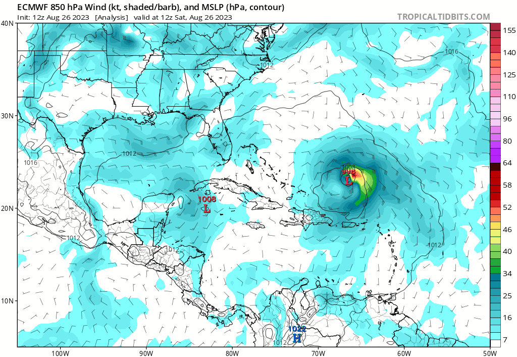
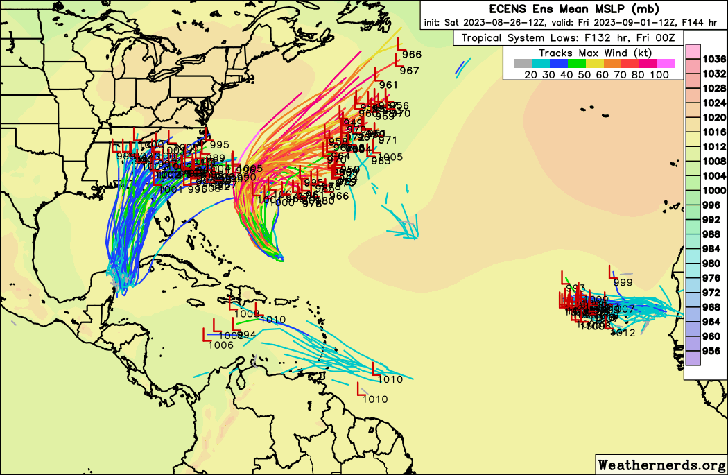
What is concerning is the uptick in intensity on all of the 12z guidance of the mesoscale hurricane models, where they typically are more useful:
https://i.imgur.com/UDSeUX0.jpg


Thank you for sharing. Can you share the link to this data on the web?


Jeff Masters does this yearly in his blog, can get all the details here - https://capeweather.com/which-hurricane-models-should-you-trust-in-2023-yale-climate-connections/
1 likes   

Fancy1002
Tropical Storm
Tropical Storm
Posts: 134
Joined: Sun Dec 25, 2022 3:47 pm

Re: ATL: INVEST 93L - Models

#202 Postby Fancy1002 » Sat Aug 26, 2023 12:53 pm

The latest HWRF run is looking interesting.
0 likes   

LAF92
Tropical Depression
Tropical Depression
Posts: 51
Joined: Fri Aug 18, 2023 6:27 pm

Re: ATL: INVEST 93L - Models

#203 Postby LAF92 » Sat Aug 26, 2023 1:00 pm

Fancy1002 wrote:The latest HWRF run is looking interesting.

We’ve all got to remember the HWRF is always on the strong side there’s not indication this storm will bomb out like the HWRF is showing. Especially with no COC formed yet
0 likes   

User avatar
Teban54
Category 5
Category 5
Posts: 3204
Joined: Sat May 19, 2018 1:19 pm

Re: ATL: INVEST 93L - Models

#204 Postby Teban54 » Sat Aug 26, 2023 1:03 pm

LAF92 wrote:Especially with no COC formed yet

I beg to differ.
Last edited by Teban54 on Sat Aug 26, 2023 1:09 pm, edited 1 time in total.
1 likes   

User avatar
gatorcane
S2K Supporter
S2K Supporter
Posts: 23691
Age: 47
Joined: Sun Mar 13, 2005 3:54 pm
Location: Boca Raton, FL

Re: ATL: INVEST 93L - Models

#205 Postby gatorcane » Sat Aug 26, 2023 1:05 pm

12Z HWRF shifts west and much stronger:

Image
0 likes   

SconnieCane
Category 4
Category 4
Posts: 998
Joined: Thu Aug 02, 2018 5:29 pm
Location: Madison, WI

Re: ATL: INVEST 93L - Models

#206 Postby SconnieCane » Sat Aug 26, 2023 1:06 pm

LAF92 wrote:
Fancy1002 wrote:The latest HWRF run is looking interesting.

We’ve all got to remember the HWRF is always on the strong side there’s not indication this storm will bomb out like the HWRF is showing. Especially with no COC formed yet


HAFS A & B also ate their Wheaties (or rather, their simulated 93L did) on today's 12Z run, so it's not like the HWRF is on an island.
1 likes   

Stormlover1970
Tropical Low
Tropical Low
Posts: 32
Age: 55
Joined: Sun May 22, 2022 9:26 am
Location: New Port Richey, Florida

Re: ATL: INVEST 93L - Models

#207 Postby Stormlover1970 » Sat Aug 26, 2023 1:10 pm

This isn’t even a storm yet let alone a hurricane. That’s why I trust Denis Phillips he never hypes anything. I would like to see all model runs not just the doomsday worst case scenario.
0 likes   

User avatar
Zonacane
Category 1
Category 1
Posts: 361
Joined: Tue Aug 03, 2021 2:23 pm

Re: ATL: INVEST 93L - Models

#208 Postby Zonacane » Sat Aug 26, 2023 1:14 pm

Stormlover1970 wrote:This isn’t even a storm yet let alone a hurricane. That’s why I trust Denis Phillips he never hypes anything. I would like to see all model runs not just the doomsday worst case scenario.

Global models should never really be used for intensity guidance. The concern, however, is both global and meso models are getting more intense. The potential for a high end hurricane is certainly there.
1 likes   

User avatar
gatorcane
S2K Supporter
S2K Supporter
Posts: 23691
Age: 47
Joined: Sun Mar 13, 2005 3:54 pm
Location: Boca Raton, FL

Re: ATL: INVEST 93L - Models

#209 Postby gatorcane » Sat Aug 26, 2023 1:19 pm

12Z Euro with Tampa on the dirty side. The Euro is quite a bit further east than the GFS. Normally it is the other way around so models will shift more:

Image
1 likes   

User avatar
chaser1
S2K Supporter
S2K Supporter
Posts: 5464
Age: 64
Joined: Sat Oct 15, 2005 5:59 pm
Location: Longwood, Fl

Re: ATL: INVEST 93L - Models

#210 Postby chaser1 » Sat Aug 26, 2023 1:25 pm

SconnieCane wrote:
LAF92 wrote:
Fancy1002 wrote:The latest HWRF run is looking interesting.

We’ve all got to remember the HWRF is always on the strong side there’s not indication this storm will bomb out like the HWRF is showing. Especially with no COC formed yet


HAFS A & B also ate their Wheaties (or rather, their simulated 93L did) on today's 12Z run, so it's not like the HWRF is on an island.


True, but i've become leary of all of them. I've found them to be inconsistant from a run-to-run perspective. In fairness I suppose we'll have to give both HAFS time to monitor how their forecasts verify
2 likes   
Andy D

(For official information, please refer to the NHC and NWS products.)

LarryWx
S2K Supporter
S2K Supporter
Posts: 6305
Joined: Sun Sep 07, 2003 2:04 pm
Location: GA

Re: ATL: INVEST 93L - Models

#211 Postby LarryWx » Sat Aug 26, 2023 1:32 pm

gatorcane wrote:12Z Euro with Tampa on the dirty side. The Euro is quite a bit further east than the GFS. Normally it is the other way around so models will shift more:

https://i.postimg.cc/ZYL4Jc94/ec-fast-mslp-uv850-watl-fh0-96.gif


The GFS was NW of Euro with Ian early on with a number of runs.
1 likes   
Personal Forecast Disclaimer:
The posts in this forum are NOT official forecasts and should not be used as such. They are just the opinion of the poster and may or may not be backed by sound meteorological data. They are NOT endorsed by any professional institution or storm2k.org. For official information, please refer to the NHC and NWS products.

User avatar
aspen
Category 5
Category 5
Posts: 8818
Joined: Sat Oct 12, 2019 7:10 pm
Location: Connecticut, USA

Re: ATL: INVEST 93L - Models

#212 Postby aspen » Sat Aug 26, 2023 1:48 pm

12z HWRF depicts the worst possible scenario for Florida: 93L/Idalia continues this rapid pace of organization and has minimal land interaction before getting into the Gulf, and travels in a way that makes it less impacted by shear. A Cat 4 as depicted in this run is quite unlikely to verify IMO, but I think we do need to watch out for something similar to Michael and Ian where the expected Gulf shear actually helps it strengthen.
1 likes   
Irene '11 Sandy '12 Hermine '16 5/15/2018 Derecho Fay '20 Isaias '20 Elsa '21 Henri '21 Ida '21

I am only a meteorology enthusiast who knows a decent amount about tropical cyclones. Look to the professional mets, the NHC, or your local weather office for the best information.

User avatar
cycloneye
Admin
Admin
Posts: 145299
Age: 68
Joined: Thu Oct 10, 2002 10:54 am
Location: San Juan, Puerto Rico

Re: ATL: INVEST 93L - Models

#213 Postby cycloneye » Sat Aug 26, 2023 2:04 pm

Bermuda is hit again by Idalia after Franklin did the same.

Image
2 likes   
Visit the Caribbean-Central America Weather Thread where you can find at first post web cams,radars
and observations from Caribbean basin members Click Here

User avatar
Ivanhater
Storm2k Moderator
Storm2k Moderator
Posts: 11161
Age: 38
Joined: Fri Jul 01, 2005 8:25 am
Location: Pensacola

Re: ATL: INVEST 93L - Models

#214 Postby Ivanhater » Sat Aug 26, 2023 2:06 pm

18Z Guidance in good agreement

Image

Sent from my moto g stylus 5G (2022) using Tapatalk
2 likes   
Michael

xironman
S2K Supporter
S2K Supporter
Posts: 2522
Joined: Sun Jun 10, 2007 4:53 pm
Location: NoVA

Re: ATL: INVEST 93L - Models

#215 Postby xironman » Sat Aug 26, 2023 2:10 pm

Ivanhater wrote:18Z Guidance in good agreement

https://uploads.tapatalk-cdn.com/20230826/4d25ed36933c49c55c8c8c3854ddb1c3.jpg

Sent from my moto g stylus 5G (2022) using Tapatalk


No land interaction. Plenty of tropical heat. It is all up to the upper levels and how fast it can form a core. Looks like it is taking in one last gulp of drier air. Then we will see.
1 likes   

TallyTracker
Category 2
Category 2
Posts: 734
Joined: Thu Oct 11, 2018 2:46 pm

Re: ATL: INVEST 93L - Models

#216 Postby TallyTracker » Sat Aug 26, 2023 2:24 pm

Ivanhater wrote:18Z Guidance in good agreement

https://uploads.tapatalk-cdn.com/20230826/4d25ed36933c49c55c8c8c3854ddb1c3.jpg

Sent from my moto g stylus 5G (2022) using Tapatalk


Glad I gassed both cars up and topped off my supplies last night! lol The supply rush is starting to ramp up here in Tally.
2 likes   
Fran '96, Georges '98, Gordon '00, Gabrielle '01, Charley '04, Frances '04, Jeanne '04, Barry '07, Fay '08, Debby '12, Matthew '16, Emily '17, Irma '17, Michael ‘18, Elsa ‘21, Fred ‘21, Mindy ‘21, Nicole ‘22, Idalia ‘23, Debby ‘24, Helene ‘24

User avatar
Nimbus
Category 5
Category 5
Posts: 5300
Joined: Mon Jul 19, 2004 10:54 am

Re: ATL: INVEST 93L - Models

#217 Postby Nimbus » Sat Aug 26, 2023 2:34 pm

gatorcane wrote:12Z Euro with Tampa on the dirty side. The Euro is quite a bit further east than the GFS. Normally it is the other way around so models will shift more:

https://i.postimg.cc/ZYL4Jc94/ec-fast-mslp-uv850-watl-fh0-96.gif


That is what WXman57 gave us many runs ago.
A 995 tropical storm off Tampa bay area takes out the power with 55+ mph winds.
Good warning although todays 18Z consensus is still a little farther west.
1 likes   

User avatar
gatorcane
S2K Supporter
S2K Supporter
Posts: 23691
Age: 47
Joined: Sun Mar 13, 2005 3:54 pm
Location: Boca Raton, FL

Re: ATL: INVEST 93L - Models

#218 Postby gatorcane » Sat Aug 26, 2023 2:50 pm

12Z Euro ensembles:

Image
0 likes   

User avatar
JetFuel_SE
Category 1
Category 1
Posts: 282
Age: 25
Joined: Thu Apr 30, 2020 3:57 pm

Re: ATL: INVEST 93L - Models

#219 Postby JetFuel_SE » Sat Aug 26, 2023 2:51 pm

Nimbus wrote:
gatorcane wrote:12Z Euro with Tampa on the dirty side. The Euro is quite a bit further east than the GFS. Normally it is the other way around so models will shift more:

https://i.postimg.cc/ZYL4Jc94/ec-fast-mslp-uv850-watl-fh0-96.gif


That is what WXman57 gave us many runs ago.
A 995 tropical storm off Tampa bay area takes out the power with 55+ mph winds.
Good warning although todays 18Z consensus is still a little farther west.

The Euro pretty much always underestimates storms, I wouldn't count on it for intensity.
0 likes   

User avatar
chaser1
S2K Supporter
S2K Supporter
Posts: 5464
Age: 64
Joined: Sat Oct 15, 2005 5:59 pm
Location: Longwood, Fl

Re: ATL: INVEST 93L - Models

#220 Postby chaser1 » Sat Aug 26, 2023 2:53 pm

Toughest part is that until we have a confirmed well defined core, then its reasonable to think that modeling will potentially fluctuate given the uncertainty of good initialization. Of course this is especially true with regard to timing. The point "when" forward motion occurs (sooner or later) will largely bear out the timing of interplay with other factors that may dictate how much (or little) upper level shear will factor in
0 likes   
Andy D

(For official information, please refer to the NHC and NWS products.)


Return to “2023”

Who is online

Users browsing this forum: No registered users and 1 guest