ATL: IDALIA - Models
Moderator: S2k Moderators
-
chris_fit

- Category 5

- Posts: 3261
- Age: 43
- Joined: Wed Sep 10, 2003 11:58 pm
- Location: Tampa Bay Area, FL
Re: ATL: INVEST 93L - Models
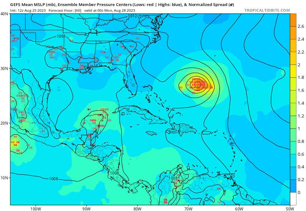
Most 12Z GFS coming in well E of the 12z GFS OP Run.
GFS Ens trending stronger.

GFS Ens trending stronger.
0 likes
-
gatorcane

- S2K Supporter

- Posts: 23708
- Age: 48
- Joined: Sun Mar 13, 2005 3:54 pm
- Location: Boca Raton, FL
Re: ATL: INVEST 93L - Models
Loop of 12Z GEFS. A bit stronger and a bit more west than the 06Z GEFS.
1 likes
-
cycloneye

- Admin

- Posts: 149826
- Age: 69
- Joined: Thu Oct 10, 2002 10:54 am
- Location: San Juan, Puerto Rico
Re: ATL: INVEST 93L - Models
First run from SHIP and is bullish. It will be interesting to see the first runs from HWRF, HMON and HAFS A-B.

1 likes
Visit the Caribbean-Central America Weather Thread where you can find at first post web cams,radars
and observations from Caribbean basin members Click Here
and observations from Caribbean basin members Click Here
Re: ATL: INVEST 93L - Models
For record-keeping purposes, I'm putting the last four 12 hourly UKMET runs here:
1) 8/24 0Z run:
Has a TD forming just S of W Cuba that later moves NE over S FL:
NEW TROPICAL CYCLONE FORECAST TO DEVELOP AFTER 96 HOURS
FORECAST POSITION AT T+ 96 : 22.1N 83.2W
LEAD CENTRAL MAXIMUM WIND
VERIFYING TIME TIME POSITION PRESSURE (MB) SPEED (KNOTS)
-------------- ---- -------- ------------- -------------
0000UTC 28.08.2023 96 22.1N 83.2W 1004 26
1200UTC 28.08.2023 108 23.6N 82.2W 1005 33
0000UTC 29.08.2023 120 24.9N 81.8W 1005 26
1200UTC 29.08.2023 132 27.2N 80.2W 1007 26
0000UTC 30.08.2023 144 28.2N 80.5W 1005 27
1200UTC 30.08.2023 156 30.3N 78.3W 1007 27
0000UTC 31.08.2023 168 32.1N 76.1W 1006 28
-----------------------------
2) 8/24 12Z run:
This run is significantly stronger than the 8/24 0Z run (partially due to being over water longer) with a TS instead of just a TD. Also, instead of it moving NE across S FL, it moves NE from the FL Big Bend across N FL into the Atlantic:
NEW TROPICAL CYCLONE FORECAST TO DEVELOP AFTER 72 HOURS
FORECAST POSITION AT T+ 72 : 20.9N 86.3W
LEAD CENTRAL MAXIMUM WIND
VERIFYING TIME TIME POSITION PRESSURE (MB) SPEED (KNOTS)
-------------- ---- -------- ------------- -------------
1200UTC 27.08.2023 72 20.9N 86.3W 1005 22
0000UTC 28.08.2023 84 21.2N 85.7W 1003 24
1200UTC 28.08.2023 96 22.8N 84.8W 1002 36
0000UTC 29.08.2023 108 24.8N 83.7W 1000 36
1200UTC 29.08.2023 120 27.2N 83.6W 997 38
0000UTC 30.08.2023 132 28.6N 83.4W 994 37
1200UTC 30.08.2023 144 30.3N 82.1W 994 40
0000UTC 31.08.2023 156 32.3N 79.5W 993 41
1200UTC 31.08.2023 168 34.4N 77.1W 996 39
-----------------------------
3) 8/25 0Z run:
a bit stronger than 8/24 12Z run (60 mph when goes offshore E US at end) (UKMET often conservative with winds as 990 mb usually corresponds to stronger TS than 50 mph) with similar to 8/24 12Z run but with slight NW shift. It again landfalls in the FL Big Bend and then goes NE through SE GA and then offshore from SC:
NEW TROPICAL CYCLONE FORECAST TO DEVELOP AFTER 66 HOURS
FORECAST POSITION AT T+ 66 : 21.4N 88.3W
LEAD CENTRAL MAXIMUM WIND
VERIFYING TIME TIME POSITION PRESSURE (MB) SPEED (KNOTS)
-------------- ---- -------- ------------- -------------
0000UTC 28.08.2023 72 21.3N 87.9W 1004 22
1200UTC 28.08.2023 84 23.4N 86.2W 1000 43
0000UTC 29.08.2023 96 25.1N 84.9W 996 39
1200UTC 29.08.2023 108 27.6N 84.8W 992 40
0000UTC 30.08.2023 120 29.2N 83.9W 990 43
1200UTC 30.08.2023 132 31.3N 82.0W 993 44
0000UTC 31.08.2023 144 33.1N 78.5W 991 45
1200UTC 31.08.2023 156 34.4N 74.6W 991 48
0000UTC 01.09.2023 168 35.2N 70.6W 993 52
-------------------------------
4) 8/25 12Z run (latest):
track is SE of 8/25 0Z run but still landfalls near FL Big Bend; then moves NE to off the SE US; still a TS but a bit weaker than 0Z run due maybe to the further SE track:
NEW TROPICAL CYCLONE FORECAST TO DEVELOP AFTER 84 HOURS
FORECAST POSITION AT T+ 84 : 23.2N 85.4W
LEAD CENTRAL MAXIMUM WIND
VERIFYING TIME TIME POSITION PRESSURE (MB) SPEED (KNOTS)
-------------- ---- -------- ------------- -------------
0000UTC 29.08.2023 84 23.2N 85.4W 1005 31
1200UTC 29.08.2023 96 25.8N 83.9W 1002 38
0000UTC 30.08.2023 108 28.3N 82.7W 999 32
1200UTC 30.08.2023 120 31.7N 80.4W 1000 34
0000UTC 31.08.2023 132 32.8N 77.9W 1000 35
1200UTC 31.08.2023 144 33.9N 74.5W 1000 32
0000UTC 01.09.2023 156 34.3N 71.9W 1001 39
1200UTC 01.09.2023 168 34.2N 69.2W 1002 36
0 likes
Personal Forecast Disclaimer:
The posts in this forum are NOT official forecasts and should not be used as such. They are just the opinion of the poster and may or may not be backed by sound meteorological data. They are NOT endorsed by any professional institution or storm2k.org. For official information, please refer to the NHC and NWS products.
The posts in this forum are NOT official forecasts and should not be used as such. They are just the opinion of the poster and may or may not be backed by sound meteorological data. They are NOT endorsed by any professional institution or storm2k.org. For official information, please refer to the NHC and NWS products.
-
wxman57

- Moderator-Pro Met

- Posts: 23177
- Age: 68
- Joined: Sat Jun 21, 2003 8:06 pm
- Location: Houston, TX (southwest)
Re: ATL: INVEST 93L - Models
Models trending a little farther north with FL landfall. Maybe Big Bend to northern Peninsula. I'm working Franklin an Damrey. Coworker has 93L and Saola.
4 likes
-
SFLcane

- S2K Supporter
- Posts: 10281
- Age: 48
- Joined: Sat Jun 05, 2010 1:44 pm
- Location: Lake Worth Florida
Re: ATL: INVEST 93L - Models
LarryWx wrote:For record-keeping purposes, I'm putting the last four 12 hourly UKMET runs here:
1) 8/24 0Z run:
Has a TD forming just S of W Cuba that later moves NE over S FL:
NEW TROPICAL CYCLONE FORECAST TO DEVELOP AFTER 96 HOURS
FORECAST POSITION AT T+ 96 : 22.1N 83.2W
LEAD CENTRAL MAXIMUM WIND
VERIFYING TIME TIME POSITION PRESSURE (MB) SPEED (KNOTS)
-------------- ---- -------- ------------- -------------
0000UTC 28.08.2023 96 22.1N 83.2W 1004 26
1200UTC 28.08.2023 108 23.6N 82.2W 1005 33
0000UTC 29.08.2023 120 24.9N 81.8W 1005 26
1200UTC 29.08.2023 132 27.2N 80.2W 1007 26
0000UTC 30.08.2023 144 28.2N 80.5W 1005 27
1200UTC 30.08.2023 156 30.3N 78.3W 1007 27
0000UTC 31.08.2023 168 32.1N 76.1W 1006 28
-----------------------------
2) 8/24 12Z run:
This run is significantly stronger than the 8/24 0Z run (partially due to being over water longer) with a TS instead of just a TD. Also, instead of it moving NE across S FL, it moves NE from the FL Big Bend across N FL into the Atlantic:
NEW TROPICAL CYCLONE FORECAST TO DEVELOP AFTER 72 HOURS
FORECAST POSITION AT T+ 72 : 20.9N 86.3W
LEAD CENTRAL MAXIMUM WIND
VERIFYING TIME TIME POSITION PRESSURE (MB) SPEED (KNOTS)
-------------- ---- -------- ------------- -------------
1200UTC 27.08.2023 72 20.9N 86.3W 1005 22
0000UTC 28.08.2023 84 21.2N 85.7W 1003 24
1200UTC 28.08.2023 96 22.8N 84.8W 1002 36
0000UTC 29.08.2023 108 24.8N 83.7W 1000 36
1200UTC 29.08.2023 120 27.2N 83.6W 997 38
0000UTC 30.08.2023 132 28.6N 83.4W 994 37
1200UTC 30.08.2023 144 30.3N 82.1W 994 40
0000UTC 31.08.2023 156 32.3N 79.5W 993 41
1200UTC 31.08.2023 168 34.4N 77.1W 996 39
-----------------------------
3) 8/25 0Z run:
a bit stronger than 8/24 12Z run (60 mph when goes offshore E US at end) (UKMET often conservative with winds as 990 mb usually corresponds to stronger TS than 50 mph) with similar to 8/24 12Z run but with slight NW shift. It again landfalls in the FL Big Bend and then goes NE through SE GA and then offshore from SC:
NEW TROPICAL CYCLONE FORECAST TO DEVELOP AFTER 66 HOURS
FORECAST POSITION AT T+ 66 : 21.4N 88.3W
LEAD CENTRAL MAXIMUM WIND
VERIFYING TIME TIME POSITION PRESSURE (MB) SPEED (KNOTS)
-------------- ---- -------- ------------- -------------
0000UTC 28.08.2023 72 21.3N 87.9W 1004 22
1200UTC 28.08.2023 84 23.4N 86.2W 1000 43
0000UTC 29.08.2023 96 25.1N 84.9W 996 39
1200UTC 29.08.2023 108 27.6N 84.8W 992 40
0000UTC 30.08.2023 120 29.2N 83.9W 990 43
1200UTC 30.08.2023 132 31.3N 82.0W 993 44
0000UTC 31.08.2023 144 33.1N 78.5W 991 45
1200UTC 31.08.2023 156 34.4N 74.6W 991 48
0000UTC 01.09.2023 168 35.2N 70.6W 993 52
-------------------------------
4) 8/25 12Z run (latest):
track is SE of 8/25 0Z run but still landfalls near FL Big Bend; then moves NE to off the SE US; still a TS but a bit weaker than 0Z run due maybe to the further SE track:
NEW TROPICAL CYCLONE FORECAST TO DEVELOP AFTER 84 HOURS
FORECAST POSITION AT T+ 84 : 23.2N 85.4W
LEAD CENTRAL MAXIMUM WIND
VERIFYING TIME TIME POSITION PRESSURE (MB) SPEED (KNOTS)
-------------- ---- -------- ------------- -------------
0000UTC 29.08.2023 84 23.2N 85.4W 1005 31
1200UTC 29.08.2023 96 25.8N 83.9W 1002 38
0000UTC 30.08.2023 108 28.3N 82.7W 999 32
1200UTC 30.08.2023 120 31.7N 80.4W 1000 34
0000UTC 31.08.2023 132 32.8N 77.9W 1000 35
1200UTC 31.08.2023 144 33.9N 74.5W 1000 32
0000UTC 01.09.2023 156 34.3N 71.9W 1001 39
1200UTC 01.09.2023 168 34.2N 69.2W 1002 36
0 likes

Re: ATL: INVEST 93L - Models
SFLcane wrote:LarryWx wrote:For record-keeping purposes, I'm putting the last four 12 hourly UKMET runs here:
1) 8/24 0Z run:
Has a TD forming just S of W Cuba that later moves NE over S FL:
NEW TROPICAL CYCLONE FORECAST TO DEVELOP AFTER 96 HOURS
FORECAST POSITION AT T+ 96 : 22.1N 83.2W
LEAD CENTRAL MAXIMUM WIND
VERIFYING TIME TIME POSITION PRESSURE (MB) SPEED (KNOTS)
-------------- ---- -------- ------------- -------------
0000UTC 28.08.2023 96 22.1N 83.2W 1004 26
1200UTC 28.08.2023 108 23.6N 82.2W 1005 33
0000UTC 29.08.2023 120 24.9N 81.8W 1005 26
1200UTC 29.08.2023 132 27.2N 80.2W 1007 26
0000UTC 30.08.2023 144 28.2N 80.5W 1005 27
1200UTC 30.08.2023 156 30.3N 78.3W 1007 27
0000UTC 31.08.2023 168 32.1N 76.1W 1006 28
-----------------------------
2) 8/24 12Z run:
This run is significantly stronger than the 8/24 0Z run (partially due to being over water longer) with a TS instead of just a TD. Also, instead of it moving NE across S FL, it moves NE from the FL Big Bend across N FL into the Atlantic:
NEW TROPICAL CYCLONE FORECAST TO DEVELOP AFTER 72 HOURS
FORECAST POSITION AT T+ 72 : 20.9N 86.3W
LEAD CENTRAL MAXIMUM WIND
VERIFYING TIME TIME POSITION PRESSURE (MB) SPEED (KNOTS)
-------------- ---- -------- ------------- -------------
1200UTC 27.08.2023 72 20.9N 86.3W 1005 22
0000UTC 28.08.2023 84 21.2N 85.7W 1003 24
1200UTC 28.08.2023 96 22.8N 84.8W 1002 36
0000UTC 29.08.2023 108 24.8N 83.7W 1000 36
1200UTC 29.08.2023 120 27.2N 83.6W 997 38
0000UTC 30.08.2023 132 28.6N 83.4W 994 37
1200UTC 30.08.2023 144 30.3N 82.1W 994 40
0000UTC 31.08.2023 156 32.3N 79.5W 993 41
1200UTC 31.08.2023 168 34.4N 77.1W 996 39
-----------------------------
3) 8/25 0Z run:
a bit stronger than 8/24 12Z run (60 mph when goes offshore E US at end) (UKMET often conservative with winds as 990 mb usually corresponds to stronger TS than 50 mph) with similar to 8/24 12Z run but with slight NW shift. It again landfalls in the FL Big Bend and then goes NE through SE GA and then offshore from SC:
NEW TROPICAL CYCLONE FORECAST TO DEVELOP AFTER 66 HOURS
FORECAST POSITION AT T+ 66 : 21.4N 88.3W
LEAD CENTRAL MAXIMUM WIND
VERIFYING TIME TIME POSITION PRESSURE (MB) SPEED (KNOTS)
-------------- ---- -------- ------------- -------------
0000UTC 28.08.2023 72 21.3N 87.9W 1004 22
1200UTC 28.08.2023 84 23.4N 86.2W 1000 43
0000UTC 29.08.2023 96 25.1N 84.9W 996 39
1200UTC 29.08.2023 108 27.6N 84.8W 992 40
0000UTC 30.08.2023 120 29.2N 83.9W 990 43
1200UTC 30.08.2023 132 31.3N 82.0W 993 44
0000UTC 31.08.2023 144 33.1N 78.5W 991 45
1200UTC 31.08.2023 156 34.4N 74.6W 991 48
0000UTC 01.09.2023 168 35.2N 70.6W 993 52
-------------------------------
4) 8/25 12Z run (latest):
track is SE of 8/25 0Z run but still landfalls near FL Big Bend; then moves NE to off the SE US; still a TS but a bit weaker than 0Z run due maybe to the further SE track:
NEW TROPICAL CYCLONE FORECAST TO DEVELOP AFTER 84 HOURS
FORECAST POSITION AT T+ 84 : 23.2N 85.4W
LEAD CENTRAL MAXIMUM WIND
VERIFYING TIME TIME POSITION PRESSURE (MB) SPEED (KNOTS)
-------------- ---- -------- ------------- -------------
0000UTC 29.08.2023 84 23.2N 85.4W 1005 31
1200UTC 29.08.2023 96 25.8N 83.9W 1002 38
0000UTC 30.08.2023 108 28.3N 82.7W 999 32
1200UTC 30.08.2023 120 31.7N 80.4W 1000 34
0000UTC 31.08.2023 132 32.8N 77.9W 1000 35
1200UTC 31.08.2023 144 33.9N 74.5W 1000 32
0000UTC 01.09.2023 156 34.3N 71.9W 1001 39
1200UTC 01.09.2023 168 34.2N 69.2W 1002 36
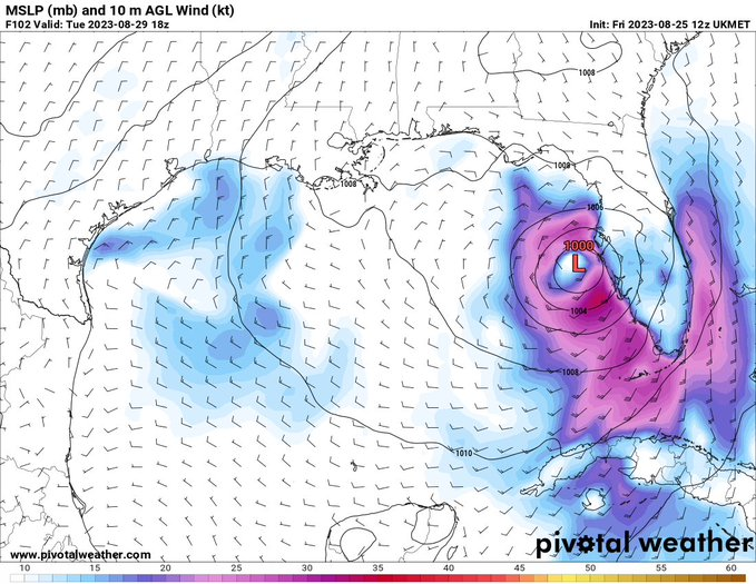
https://i.postimg.cc/wTf9m0Kr/uk.png
Euro and uk are similar a lot of times. Lets see if 12z euro trends back east a bit
0 likes
-
Spacecoast

- Category 2

- Posts: 773
- Joined: Thu Aug 31, 2017 2:03 pm

-
CrazyC83
- Professional-Met

- Posts: 34316
- Joined: Tue Mar 07, 2006 11:57 pm
- Location: Deep South, for the first time!
Re: ATL: INVEST 93L - Models
This calls for additional balloon launches. That fast track to the Panhandle is very reasonable with a faster movement - and it would be less than 120 hours away. That's not a lot of time.
2 likes

Re: ATL: INVEST 93L - Models
The GFS goes from totally ignoring it, to the strongest model run of them all. Nice and consistent modeling 
2 likes
Re: ATL: INVEST 93L - Models
CrazyC83 wrote:This calls for additional balloon launches. That fast track to the Panhandle is very reasonable with a faster movement - and it would be less than 120 hours away. That's not a lot of time.
Faster movement favors an eastern track. Models have slowed down timing of impact allowing high pressure to build in from the east.
0 likes

Re: ATL: INVEST 93L - Models
Salute!
Hate to see some projections, especially ones with landfall following the foot steps of Ian. Sheesh. I remember Elena back in 1985.
In any case, the Gulf plays many games with these things, including mysterious dissipation sometimes.
And how do we pronouce the possible name Idalia? Like with short "i" as in "Italy" ? or stong "i" as in "idle"?
Gums sends...
1 likes
-
AnnularCane

- S2K Supporter
- Posts: 2965
- Joined: Thu Jun 08, 2006 9:18 am
- Location: Wytheville, VA
Re: ATL: INVEST 93L - Models
Gums wrote:Salute!
Hate to see some projections, especially ones with landfall following the foot steps of Ian. Sheesh. I remember Elena back in 1985.
In any case, the Gulf plays many games with these things, including mysterious dissipation sometimes.
And how do we pronouce the possible name Idalia? Like with short "i" as in "Italy" ? or stong "i" as in "idle"?
Gums sends...
Someone here said "ee-DAL-ya" or something like that. I was thinking "i-DAIL-ya", which I thought was prettier, but okay.
0 likes
"But it never rained rain. It never snowed snow. And it never blew just wind. It rained things like soup and juice. It snowed mashed potatoes and green peas. And sometimes the wind blew in storms of hamburgers." -- Judi Barrett, Cloudy with a Chance of Meatballs
-
chris_fit
- Category 5
- Posts: 3261
- Age: 43
- Joined: Wed Sep 10, 2003 11:58 pm
- Location: Tampa Bay Area, FL
Re: ATL: INVEST 93L - Models
12Z EURO running and coming in with a slightly better defined signature through 36 hours. Maybe a hair E but meaningless.
0 likes
-
tolakram
- Admin
- Posts: 20188
- Age: 62
- Joined: Sun Aug 27, 2006 8:23 pm
- Location: Florence, KY (name is Mark)
Re: ATL: INVEST 93L - Models
12Z GFS

12Z CMC

12Z ICON

12Z Euro

12Z CMC
12Z ICON
12Z Euro
0 likes
M a r k
- - - - -
Join us in chat: Storm2K Chatroom Invite. Android and IOS apps also available.
The posts in this forum are NOT official forecasts and should not be used as such. Posts are NOT endorsed by any professional institution or STORM2K.org. For official information and forecasts, please refer to NHC and NWS products.
-
Spacecoast
- Category 2
- Posts: 773
- Joined: Thu Aug 31, 2017 2:03 pm


Re: ATL: INVEST 93L - Models
It seems like the 12z euro isn't staying over land as much (or as far into the yucatan) as the 0/6z.
0 likes

Who is online
Users browsing this forum: No registered users and 14 guests