Low Pressure in the Northwest Caribbean Sea (Is Invest 93L)

This is the general tropical discussion area. Anyone can take their shot at predicting a storms path.

Moderator: S2k Moderators

Forum rules

The posts in this forum are NOT official forecasts and should not be used as such. They are just the opinion of the poster and may or may not be backed by sound meteorological data. They are NOT endorsed by any professional institution or STORM2K. For official information, please refer to products from the National Hurricane Center and National Weather Service.

Help Support Storm2K
Message
Author
User avatar
Spacecoast
Category 2
Category 2
Posts: 758
Joined: Thu Aug 31, 2017 2:03 pm

Re: Possible Development in the Northwestern Caribbean

#201 Postby Spacecoast » Thu Aug 24, 2023 6:33 pm

Ran across this real-time Genesis product.... FWIW, I believe it is GFS-centric.

Image
Tropical Cyclone Genesis Index
The main goal of this project is to develop a disturbance-following tropical cyclone (TC) genesis index (TCGI) to provide forecasters with an objective tool for identifying the 0-48hr and 0-120hr probability of TC genesis in the North Atlantic basin. Predictors from a variety of sources were tested and potentially integrated into this new scheme and included Dvorak T-number / CI value estimates, environmental and convective parameters currently used in the NESDIS TC Formation Probability (TCFP) product (fixed grid scheme), environmental parameters from the Statistical Hurricane Intensity Prediction Scheme (SHIPS) that are relevant to TC genesis, and total precipitable water (TPW) retrievals from microwave satellites. Six robust TCGI predictors were identified and have been incorporated into an experimental real-time version of TCGI.
Last edited by Spacecoast on Thu Aug 24, 2023 6:56 pm, edited 2 times in total.
0 likes   

User avatar
cycloneye
Admin
Admin
Posts: 145292
Age: 68
Joined: Thu Oct 10, 2002 10:54 am
Location: San Juan, Puerto Rico

Re: Possible Development in the Northwestern Caribbean

#202 Postby cycloneye » Thu Aug 24, 2023 6:37 pm

Code Red

Northwestern Caribbean Sea and eastern Gulf of Mexico:
A broad area of low pressure has developed over the northwestern
Caribbean Sea just off the northeastern coast of Honduras, producing
disorganized shower and thunderstorm activity. Environmental
conditions appear conducive for gradual development of this system
during the next several days, and a tropical depression is likely to
form late this weekend or early next week while moving generally
northward over the northwestern Caribbean Sea and eastern Gulf of
Mexico. Interests in the Yucatan Peninsula of Mexico, western Cuba,
and Florida should monitor the progress of this system.
* Formation chance through 48 hours...low...20 percent.
* Formation chance through 7 days...high...70 percent.


Image
3 likes   
Visit the Caribbean-Central America Weather Thread where you can find at first post web cams,radars
and observations from Caribbean basin members Click Here

User avatar
CronkPSU
S2K Supporter
S2K Supporter
Posts: 2014
Joined: Sun Aug 07, 2005 10:44 pm
Location: Avalon Park, FL

Re: Possible Development in the Northwestern Caribbean

#203 Postby CronkPSU » Thu Aug 24, 2023 6:40 pm

Spacecoast wrote:Ran across this real-time Genesis product.... FWIW

https://i.ibb.co/1MfwcW1/ef32.jpg
Tropical Cyclone Genesis Index
The main goal of this project is to develop a disturbance-following tropical cyclone (TC) genesis index (TCGI) to provide forecasters with an objective tool for identifying the 0-48hr and 0-120hr probability of TC genesis in the North Atlantic basin. Predictors from a variety of sources were tested and potentially integrated into this new scheme and included Dvorak T-number / CI value estimates, environmental and convective parameters currently used in the NESDIS TC Formation Probability (TCFP) product (fixed grid scheme), environmental parameters from the Statistical Hurricane Intensity Prediction Scheme (SHIPS) that are relevant to TC genesis, and total precipitable water (TPW) retrievals from microwave satellites. Six robust TCGI predictors were identified and have been incorporated into an experimental real-time version of TCGI.


so this is saying there is NO chance of this developing? that seems...odd...considering a few major models have something developing
1 likes   
Just like Jon Snow..."I know nothing" except what I know, and most of what I know is gathered by the fine people of the NHC

Stratton23
Category 5
Category 5
Posts: 2518
Joined: Fri Jul 21, 2023 10:59 pm
Location: Katy, Tx

Re: Possible Development in the Northwestern Caribbean: 8 PM TWO=Code Red

#204 Postby Stratton23 » Thu Aug 24, 2023 6:43 pm

I would say the GFS, and GEFS are very likely going to bust badly, i wouldnt even bother using that guidance for this system, its actually comical how bad that model has been with genesis this year lol
2 likes   

User avatar
MetroMike
Category 4
Category 4
Posts: 952
Joined: Sun Aug 29, 2004 8:13 pm
Location: Tampa Bay
Contact:

Re: Possible Development in the Northwestern Caribbean: 8 PM TWO=Code Red

#205 Postby MetroMike » Thu Aug 24, 2023 6:45 pm

When do we think it will be tagged an Invest?
1 likes   

User avatar
cycloneye
Admin
Admin
Posts: 145292
Age: 68
Joined: Thu Oct 10, 2002 10:54 am
Location: San Juan, Puerto Rico

Re: Possible Development in the Northwestern Caribbean: 8 PM TWO=Code Red

#206 Postby cycloneye » Thu Aug 24, 2023 6:46 pm

MetroMike wrote:When do we think it will be tagged an Invest?


At anytime they may pull the trigger.
2 likes   
Visit the Caribbean-Central America Weather Thread where you can find at first post web cams,radars
and observations from Caribbean basin members Click Here

User avatar
Spacecoast
Category 2
Category 2
Posts: 758
Joined: Thu Aug 31, 2017 2:03 pm

Re: Possible Development in the Northwestern Caribbean

#207 Postby Spacecoast » Thu Aug 24, 2023 6:46 pm

CronkPSU wrote:
Spacecoast wrote:Ran across this real-time Genesis product.... FWIW

https://i.ibb.co/1MfwcW1/ef32.jpg
Tropical Cyclone Genesis Index
The main goal of this project is to develop a disturbance-following tropical cyclone (TC) genesis index (TCGI) to provide forecasters with an objective tool for identifying the 0-48hr and 0-120hr probability of TC genesis in the North Atlantic basin. Predictors from a variety of sources were tested and potentially integrated into this new scheme and included Dvorak T-number / CI value estimates, environmental and convective parameters currently used in the NESDIS TC Formation Probability (TCFP) product (fixed grid scheme), environmental parameters from the Statistical Hurricane Intensity Prediction Scheme (SHIPS) that are relevant to TC genesis, and total precipitable water (TPW) retrievals from microwave satellites. Six robust TCGI predictors were identified and have been incorporated into an experimental real-time version of TCGI.


so this is saying there is NO chance of this developing? that seems...odd...considering a few major models have something developing


It does appear to use the GFS as one of the major inputs, so that explains the 'no chance' output. What seems odd (to me), is that the GFS/GEFS still hasn't hinted at development, and the genesis averse Euro has been very agressive.
You can see other 'swirls' spinning up on the GFS happy hour run, so it's not like it has become suddenly shy.
Last edited by Spacecoast on Thu Aug 24, 2023 6:53 pm, edited 2 times in total.
2 likes   

User avatar
SFLcane
S2K Supporter
S2K Supporter
Posts: 10163
Age: 47
Joined: Sat Jun 05, 2010 1:44 pm
Location: Lake Worth Florida

Re: Possible Development in the Northwestern Caribbean: 8 PM TWO=Code Red

#208 Postby SFLcane » Thu Aug 24, 2023 6:52 pm

The heck with the gfs… per nhc lol
5 likes   

StormPyrate
Category 1
Category 1
Posts: 279
Joined: Sun May 27, 2018 8:41 pm
Location: Clearwater, FL

Re: Possible Development in the Northwestern Caribbean: 8 PM TWO=Code Red

#209 Postby StormPyrate » Thu Aug 24, 2023 6:58 pm

its quite interesting, did the GFS not get major upgrades this year?
For the NHS to totally ignore it, is wild.
1 likes   
St Petersburg Florida

jlauderdal
S2K Supporter
S2K Supporter
Posts: 7182
Joined: Wed May 19, 2004 5:46 am
Location: NE Fort Lauderdale
Contact:

Re: RE: Re: Possible Development in the Northwestern Caribbean: 8 PM TWO=Code Red

#210 Postby jlauderdal » Thu Aug 24, 2023 6:58 pm

SFLcane wrote:The heck with the gfs… per nhc lol
A rare tossing out the gfs
3 likes   

User avatar
SFLcane
S2K Supporter
S2K Supporter
Posts: 10163
Age: 47
Joined: Sat Jun 05, 2010 1:44 pm
Location: Lake Worth Florida

Re: Possible Development in the Northwestern Caribbean: 8 PM TWO=Code Red

#211 Postby SFLcane » Thu Aug 24, 2023 7:07 pm

Now can we just get some hwrf going! :slime:
0 likes   

User avatar
N2FSU
S2K Supporter
S2K Supporter
Posts: 1062
Joined: Thu Sep 04, 2003 2:04 pm
Location: Tallahassee, FL

Re: Possible Development in the Northwestern Caribbean: 8 PM TWO=Code Red

#212 Postby N2FSU » Thu Aug 24, 2023 7:07 pm

It's quite obvious the NHC is tossing out the GFS with their increase to a 70% chance of development.
2 likes   

Sciencerocks
Category 5
Category 5
Posts: 9155
Age: 39
Joined: Thu Jul 06, 2017 1:51 am

Re: Possible Development in the Northwestern Caribbean: 8 PM TWO=Code Red

#213 Postby Sciencerocks » Thu Aug 24, 2023 7:10 pm

Image
0 likes   

User avatar
Kingarabian
S2K Supporter
S2K Supporter
Posts: 15980
Joined: Sat Aug 08, 2009 3:06 am
Location: Honolulu, Hawaii

Re: Possible Development in the Northwestern Caribbean: 8 PM TWO=Code Red

#214 Postby Kingarabian » Thu Aug 24, 2023 7:12 pm

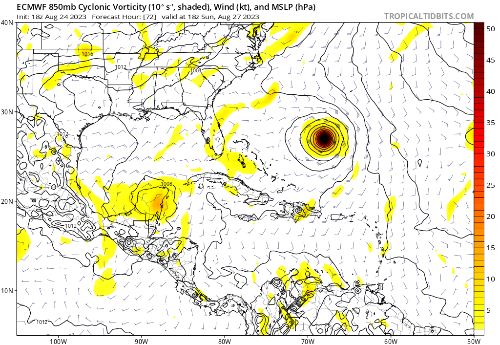
18z Euro has the 850mb vort attempting to consolidate more NW and over the Yucatan through 72 hours.

Image
1 likes   
RIP Kobe Bryant

User avatar
Hypercane_Kyle
Category 5
Category 5
Posts: 3352
Joined: Sat Mar 07, 2015 7:58 pm
Location: Cape Canaveral, FL

Re: Possible Development in the Northwestern Caribbean: 8 PM TWO=Code Red

#215 Postby Hypercane_Kyle » Thu Aug 24, 2023 7:16 pm

Surprised the GFS is struggling so much with this one, normally it's the Euro struggling with these setups and GFS predicting genesis.
2 likes   
My posts are my own personal opinion, defer to the National Hurricane Center (NHC) and other NOAA products for decision making during hurricane season.

IcyTundra
Category 5
Category 5
Posts: 1205
Joined: Mon Jun 07, 2021 9:32 pm
Location: Dickinson, Texas

Re: Possible Development in the Northwestern Caribbean: 8 PM TWO=Code Red

#216 Postby IcyTundra » Thu Aug 24, 2023 7:19 pm

Probably not going to happen but I hope that it stalls long enough to miss the trough and we can get some of that moisture to come to Texas. Central Texas coast to the Upper Texas coast is in a extreme drought right now.
0 likes   

Ianswfl
Category 1
Category 1
Posts: 482
Joined: Thu Mar 23, 2023 11:11 pm

Re: Possible Development in the Northwestern Caribbean

#217 Postby Ianswfl » Thu Aug 24, 2023 7:28 pm

NHC 8pm has shifted it slightly eastwawrd and has the X over water now. Seems they think this will consolidate more east.
0 likes   

User avatar
GCANE
S2K Supporter
S2K Supporter
Posts: 11496
Joined: Mon Oct 22, 2007 8:03 am

Re: Possible Development in the Northwestern Caribbean

#218 Postby GCANE » Thu Aug 24, 2023 7:30 pm

Will be interesting to see how this model pans out.
AI based Pangu
Latest run has Tampa Bay taking the hit.

https://charts.ecmwf.int/products/pangu ... 2308300000
0 likes   

User avatar
wxman57
Moderator-Pro Met
Moderator-Pro Met
Posts: 22978
Age: 67
Joined: Sat Jun 21, 2003 8:06 pm
Location: Houston, TX (southwest)

Re: Possible Development in the Northwestern Caribbean

#219 Postby wxman57 » Thu Aug 24, 2023 7:33 pm

TomballEd wrote:
wxman57 wrote:
Hurricaneman wrote:Looks as though there’s a broad low over the borders of El Salvador, Honduras and Nicaragua, might be in the Caribbean by tonight or tomorrow


Shows up clearly on the Euro 850mb vorticity maps. While I'm not inclined to believe the Euro's hurricane hit, I do think it could be a TD/TS. I'll take one of those for SE TX.


Sadly there is one of 50 Euro ensembles through 240 hours that would rain on Houston, and a 941 hurricane as a drought breaker probably isn't a good thing. Houston just broke the record with 109°F and another hour to go up another degree. Someone should start a fire weather page for Texas.


I hear thunder here in SW Houston. Passed about 5 miles to my north along I-10.
0 likes   

User avatar
wxman57
Moderator-Pro Met
Moderator-Pro Met
Posts: 22978
Age: 67
Joined: Sat Jun 21, 2003 8:06 pm
Location: Houston, TX (southwest)

Re: Possible Development in the Northwestern Caribbean: 8 PM TWO=Code Red

#220 Postby wxman57 » Thu Aug 24, 2023 7:34 pm

IcyTundra wrote:Probably not going to happen but I hope that it stalls long enough to miss the trough and we can get some of that moisture to come to Texas. Central Texas coast to the Upper Texas coast is in a extreme drought right now.


Not much chance of it coming our way.
1 likes   


Return to “Talkin' Tropics”

Who is online

Users browsing this forum: Ulf, USTropics and 40 guests