2023 Indicators (SST, SAL, MSLP, Wind shear, Steering, Instability) and Day 16+ Models

This is the general tropical discussion area. Anyone can take their shot at predicting a storms path.

Moderator: S2k Moderators

Forum rules

The posts in this forum are NOT official forecasts and should not be used as such. They are just the opinion of the poster and may or may not be backed by sound meteorological data. They are NOT endorsed by any professional institution or STORM2K. For official information, please refer to products from the National Hurricane Center and National Weather Service.

Help Support Storm2K
Message
Author
IsabelaWeather
Category 1
Category 1
Posts: 287
Age: 35
Joined: Tue Jul 07, 2020 7:29 am
Location: Isabela, Puerto Rico

Re: 2023 Indicators (SST, SAL, MSLP, Wind shear, Steering, Instability) and Day 16+ Models

#1241 Postby IsabelaWeather » Fri Aug 18, 2023 8:19 pm

Teban54 wrote:
WiscoWx02 wrote:
IcyTundra wrote:
I get that he thinks el nino is going to dominate the atlantic basin but this is definently downcasting and just a ridiculous statement.


I don’t think it’s a ridiculous statement at all. Think it’s quite plausible we go another August without a named storm. Conditions are just not good out there and I don’t for see that changing even as we head through peak season. Dry air will let up and should allow some development in the cracks in the wall of shear that will only become more prevalent as the season continues thanks to El Nino and the relentless parade of TUTT’s that are almost sure to come. I’m not saying no storms this season or season canceling but I definitely think those above average season outlooks are out the window. Below average is the most likely scenario imo based on what we have in front of us. Of course everyone interprets signals differently, just sharing my view point. If you look at the MJO graph on the CPC sight you can clearly see El Nino coupling with the atmosphere in the last month. The MJO was very progressive until mid July then it anchored itself in Phase 7-8 and has been there ever since. Rising air has also been over the Atlantic since the beginning of the month as someone else alluded to earlier in the discussion yet shear seems to have actually increased out there as we head through the month. Just what I see. 8-)

People said the exact same thing after Earl became post-tropical last year, and that's after an actual storm-free August and Earl massively busting. We know how that turned out.

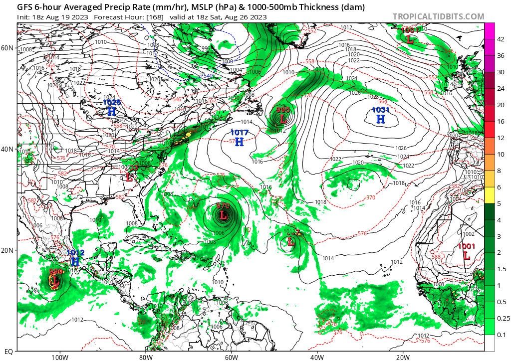
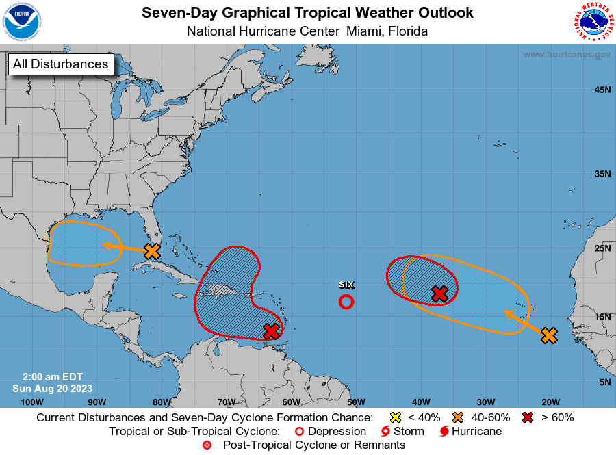
Calling for another storm-free August when we have 4 active AOIs - one of which (99L) has been claimed by weather enthusiasts to look like a TD already - is indeed ridiculous.


His severe bias is showing, just a week ago there was nothing, and now we have much more moisture, and convection than then and we arent even to bell ringing day. I think endless posts about nothing happening is very premature to say the least. It doesn't even seem like a fair viewpoint when conditions have improved as much as they have and how we have already had 5 TC's.

Its just crazy seeing this year after year before we even get to the main part of the season.

Overall so far there has been less SAL's, warmer water than usual and less shear than usual.
3 likes   

User avatar
CyclonicFury
Category 5
Category 5
Posts: 2025
Age: 26
Joined: Sun Jul 02, 2017 12:32 pm
Location: NC
Contact:

Re: 2023 Indicators (SST, SAL, MSLP, Wind shear, Steering, Instability) and Day 16+ Models

#1242 Postby CyclonicFury » Fri Aug 18, 2023 11:40 pm

While the MDR hasn't produced a TC yet in July or August, I do think it's about to really take off (at least east of the Caribbean). Record warm SSTs, below-average shear, and above-average mid level RH is a recipe for an active MDR over the next month or so. We're seeing models try to develop numerous different waves. SAL and climo have been a big inhibitor for a while, but with all these disturbances likely moistening up the MDR and climo becoming more favorable, I'd be shocked if we don't see several MDR storms (including a couple hurricanes) over the next several weeks.
4 likes   
NCSU B.S. in Meteorology Class of 2021. Tropical weather blogger at http://www.cyclonicfury.com. My forecasts and thoughts are NOT official, for official forecasts please consult the National Hurricane Center.

tolakram
Admin
Admin
Posts: 20009
Age: 62
Joined: Sun Aug 27, 2006 8:23 pm
Location: Florence, KY (name is Mark)

Re: 2023 Indicators (SST, SAL, MSLP, Wind shear, Steering, Instability) and Day 16+ Models

#1243 Postby tolakram » Sat Aug 19, 2023 8:05 am

Nothing is ridiculous, in fact calling opinions ridiculous is how we get a bunch of people all thinking the same thing. Let's see what happens.

Look at the daily runs of each model, I've never seen so much inconsistency. It makes perfect sense to this non-forecaster brain. You have incredibly good conditions EXCEPT el nino running upper air interference. Even that is below normal for an el nino year. Get some vorticity in the right place for long enough and we will get a storm.
3 likes   
M a r k
- - - - -
Join us in chat: Storm2K Chatroom Invite. Android and IOS apps also available.

The posts in this forum are NOT official forecasts and should not be used as such. Posts are NOT endorsed by any professional institution or STORM2K.org. For official information and forecasts, please refer to NHC and NWS products.

User avatar
SFLcane
S2K Supporter
S2K Supporter
Posts: 10163
Age: 47
Joined: Sat Jun 05, 2010 1:44 pm
Location: Lake Worth Florida

Re: 2023 Indicators (SST, SAL, MSLP, Wind shear, Steering, Instability) and Day 16+ Models

#1244 Postby SFLcane » Sat Aug 19, 2023 9:21 am

CyclonicFury wrote:Typical Andy Hazelton. I don't know how a pro met could season cancel so much when we have so many signals across the basin. :roll:

https://twitter.com/AndyHazelton/status/1692627920169140492?s=20

This would be so incredibly unlikely that every current AOI would have to bust, plus the CAG-like system, plus all future waves for the next 13 days.


Frankly the repetitive nature on social media daily is quite annoying. All it takes is one to find the right conditions close to were you live. We are just getting started this season
1 likes   

User avatar
Category5Kaiju
Category 5
Category 5
Posts: 4097
Joined: Thu Dec 24, 2020 12:45 pm
Location: Seattle

Re: 2023 Indicators (SST, SAL, MSLP, Wind shear, Steering, Instability) and Day 16+ Models

#1245 Postby Category5Kaiju » Sat Aug 19, 2023 9:51 am

SFLcane wrote:
CyclonicFury wrote:Typical Andy Hazelton. I don't know how a pro met could season cancel so much when we have so many signals across the basin. :roll:

https://twitter.com/AndyHazelton/status/1692627920169140492?s=20

This would be so incredibly unlikely that every current AOI would have to bust, plus the CAG-like system, plus all future waves for the next 13 days.


Frankly the repetitive nature on social media daily is quite annoying. All it takes is one to find the right conditions close to were you live. We are just getting started this season


To be honest, I'd consider Andy as a "conditional bear." What I mean by that is his default nature is to be skeptical of a season going bonkers/producing crazy storms, but when signs fall into place of such happening (and of course when they actually do happen), he does become much more serious. I remember this specifically when he was monitoring Ian. Some trackers are bullish by nature, and some are bearish by nature. But once a season is over, I think they can all reach some sort of agreement on the overall performance :)
2 likes   
Unless explicitly stated, all info in my posts is based on my own opinions and observations. Tropical storms and hurricanes can be extremely dangerous. Do not think you can beat Mother Nature. Refer to an accredited weather research agency or meteorologist if you need to make serious decisions regarding an approaching storm.

User avatar
Hypercane_Kyle
Category 5
Category 5
Posts: 3352
Joined: Sat Mar 07, 2015 7:58 pm
Location: Cape Canaveral, FL

Re: 2023 Indicators (SST, SAL, MSLP, Wind shear, Steering, Instability) and Day 16+ Models

#1246 Postby Hypercane_Kyle » Sat Aug 19, 2023 9:54 am

IcyTundra wrote:
CyclonicFury wrote:Typical Andy Hazelton. I don't know how a pro met could season cancel so much when we have so many signals across the basin. :roll:

https://twitter.com/AndyHazelton/status/1692627920169140492?s=20

This would be so incredibly unlikely that every current AOI would have to bust, plus the CAG-like system, plus all future waves for the next 13 days.


I get that he thinks el nino is going to dominate the atlantic basin but this is definently downcasting and just a ridiculous statement.


I don't think that statement is unrealistic at all. Last year was active and had no storms whatsoever in August. We're tracking a ton of systems, but almost all of the models are bearish on their output.

We appear to be heading to somewhere in the ballpark of 14-16 named this season. I think that's impressive for a moderate El Nino year.
2 likes   
My posts are my own personal opinion, defer to the National Hurricane Center (NHC) and other NOAA products for decision making during hurricane season.

User avatar
Ntxw
Storm2k Moderator
Storm2k Moderator
Posts: 22785
Joined: Wed Oct 21, 2009 6:34 pm
Location: DFW, Texas

Re: 2023 Indicators (SST, SAL, MSLP, Wind shear, Steering, Instability) and Day 16+ Models

#1247 Postby Ntxw » Sat Aug 19, 2023 11:14 am

Atlantic should see some chances. Rising motion heading over to the favored regions (Africa - IO) at least in the short to intermediate term. Beyond that we'll have to see what the low freq Nino standing wave does but at least the window will be open for a time.

Image
1 likes   
The above post and any post by Ntxw is NOT an official forecast and should not be used as such. It is just the opinion of the poster and may or may not be backed by sound meteorological data. It is NOT endorsed by any professional institution including Storm2k. For official information, please refer to NWS products.

  Help support Storm2K!
Help Support Storm2K

User avatar
Landy
Category 1
Category 1
Posts: 338
Joined: Wed Aug 11, 2021 7:43 pm
Location: Port Orange, FL

Re: 2023 Indicators (SST, SAL, MSLP, Wind shear, Steering, Instability) and Day 16+ Models

#1248 Postby Landy » Sat Aug 19, 2023 1:03 pm

One day before the bell rings. :D
Image
1 likes   

User avatar
Extratropical94
Professional-Met
Professional-Met
Posts: 3538
Age: 30
Joined: Wed Oct 20, 2010 6:36 am
Location: Hamburg, Germany
Contact:

Tropical Wave Near the Coast of Africa

#1249 Postby Extratropical94 » Sat Aug 19, 2023 1:20 pm

6 simultaneous AOIs isn't something you see everyday

Image
7 likes   
54° 11' 59'' N, 9° 9' 20'' E
Boomer Sooner!
Go Broncos! Go Cards! Go Niners!
- Daniel

User avatar
chaser1
S2K Supporter
S2K Supporter
Posts: 5464
Age: 64
Joined: Sat Oct 15, 2005 5:59 pm
Location: Longwood, Fl

Re: 2023 Indicators (SST, SAL, MSLP, Wind shear, Steering, Instability) and Day 16+ Models

#1250 Postby chaser1 » Sat Aug 19, 2023 1:28 pm

tolakram wrote:Nothing is ridiculous, in fact calling opinions ridiculous is how we get a bunch of people all thinking the same thing. Let's see what happens.

Look at the daily runs of each model, I've never seen so much inconsistency. It makes perfect sense to this non-forecaster brain. You have incredibly good conditions EXCEPT el nino running upper air interference. Even that is below normal for an el nino year. Get some vorticity in the right place for long enough and we will get a storm.


Those of us who have been around for quite some time can attest to certain years where endless days and weeks during July, August and in fewer years even September presented an Atlantic that seemed barren of moisture, or an extremely southward suppressed ITCZ, or that occasional overextended stay by Uncle Sal. Even weirder (to me), does anyone recall those few years where healthy disturbances would launch off the African coastline and convectively march themselves all the way across the MDR and into the Caribbean, with most never showing the slightest evidence of turning at any level?? Jeez, was THAT exasperating for those who simply enjoy watching the evolutionary process of genesis occur. It's kind of wild to see how each season unfolds and presents it's unique swag LOL. This year, it would seem that you can't keep disturbances from spinning; Practically everything displays some level of vorticity. Heck, it's getting to a point where I'll log onto Tidbits satellite page, hit the link displaying the entire N. Atlantic.... and half expect to see Hispaniola or Iceland turning counterclockwise. So here we are on the eve of "Gray Tropical Bell Day" with the very reasonable prospect of us seeing 2 or 3 newly named storms between now and end of month. Given how we seem to have areas of low pressure expected to develop, mid or upper-level areas of shear-induced areas of disturbed weather, and a string of tropical waves extending across the MDR it certainly wouldn't shock me to see four newly minted storms develop by Sept. 1st. Over the years we've seen plenty of tropical depressions and storms develop under less than ideal conditions and in a somewhat sheared environment, even if many remained weak, disorganized or short-lived. We've seen inactive months of August as a result of seemingly dessert like conditions throughout the tropics before yet not necessarily representative of a robust September and October. Be honest though. With all of the strong disturbances out there now, wouldn't you be a little surprised if none of them developed into a NS? If that were to occur, I think this would be telling. No "season-cancel", and still a very real risk of a deadly landfall... but quite possibly an average to below average season under a slowly increasingly coupling El Nino impact.
9 likes   
Andy D

(For official information, please refer to the NHC and NWS products.)

IcyTundra
Category 5
Category 5
Posts: 1205
Joined: Mon Jun 07, 2021 9:32 pm
Location: Dickinson, Texas

Re: 2023 Indicators (SST, SAL, MSLP, Wind shear, Steering, Instability) and Day 16+ Models

#1251 Postby IcyTundra » Sat Aug 19, 2023 4:11 pm

tolakram wrote:Nothing is ridiculous, in fact calling opinions ridiculous is how we get a bunch of people all thinking the same thing. Let's see what happens.

Look at the daily runs of each model, I've never seen so much inconsistency. It makes perfect sense to this non-forecaster brain. You have incredibly good conditions EXCEPT el nino running upper air interference. Even that is below normal for an el nino year. Get some vorticity in the right place for long enough and we will get a storm.


Yeah I agree it's good to have different opinions. I should have said that his statement that the Atlantic might have 0 tropical cyclones for the rest of August was unlikely to pan out in my opinion.
3 likes   

User avatar
gatorcane
S2K Supporter
S2K Supporter
Posts: 23691
Age: 47
Joined: Sun Mar 13, 2005 3:54 pm
Location: Boca Raton, FL

Re: 2023 Indicators (SST, SAL, MSLP, Wind shear, Steering, Instability) and Day 16+ Models

#1252 Postby gatorcane » Sat Aug 19, 2023 6:19 pm

Not surprisingly the Atlantic looks like it will become more active as we head into the last week in August and as we head towards the climo peak. Here at 168 hours, the 18Z GFS pretty much depicts my thoughts on this season from the beginning: 1) active EPAC due to El Niño 2) quiet Gulf and Caribbean due to El Niño (though we would still see sheared systems moving through those regions) and 3) big storms way out in the Atlantic with threats to the US around the mid-Atlantic northward as well as SE Canada and Bermuda due to a weaker than normal Bermuda High and above normal Atlantic SSTs:

Image
0 likes   

User avatar
SFLcane
S2K Supporter
S2K Supporter
Posts: 10163
Age: 47
Joined: Sat Jun 05, 2010 1:44 pm
Location: Lake Worth Florida

Re: 2023 Indicators (SST, SAL, MSLP, Wind shear, Steering, Instability) and Day 16+ Models

#1253 Postby SFLcane » Sat Aug 19, 2023 7:37 pm

0 likes   

User avatar
Steve
S2K Supporter
S2K Supporter
Posts: 9621
Joined: Sat Apr 05, 2003 11:41 pm
Location: Not a state-caster

Re: 2023 Indicators (SST, SAL, MSLP, Wind shear, Steering, Instability) and Day 16+ Models

#1254 Postby Steve » Sat Aug 19, 2023 11:48 pm

gatorcane wrote:Not surprisingly the Atlantic looks like it will become more active as we head into the last week in August and as we head towards the climo peak. Here at 168 hours, the 18Z GFS pretty much depicts my thoughts on this season from the beginning: 1) active EPAC due to El Niño 2) quiet Gulf and Caribbean due to El Niño (though we would still see sheared systems moving through those regions) and 3) big storms way out in the Atlantic with threats to the US around the mid-Atlantic northward as well as SE Canada and Bermuda due to a weaker than normal Bermuda High and above normal Atlantic SSTs:

https://i.postimg.cc/d0m1w996/gfs-mslp-pcpn-atl-28.png


Mostly agree. Looks almost like ACE will double in the next 2 1/2 weeks or so.
0 likes   

User avatar
Teban54
Category 5
Category 5
Posts: 3206
Joined: Sat May 19, 2018 1:19 pm

Re: 2023 Indicators (SST, SAL, MSLP, Wind shear, Steering, Instability) and Day 16+ Models

#1255 Postby Teban54 » Sun Aug 20, 2023 2:01 am

Bell-ringing day!
Image
Further updates possible later in the day.
1 likes   

Mouton
S2K Supporter
S2K Supporter
Posts: 221
Age: 79
Joined: Sat Jul 30, 2011 8:13 am
Location: Amelia Island Florida

Re: 2023 Indicators (SST, SAL, MSLP, Wind shear, Steering, Instability) and Day 16+ Models

#1256 Postby Mouton » Sun Aug 20, 2023 7:50 am

Please keep in mind Andrew, with an A as in first, was a August 25th 0f 1992 landfall in Florida. It only takes one.
1 likes   

WeatherBoy2000
Category 1
Category 1
Posts: 346
Joined: Mon Apr 10, 2023 9:29 am

Re: 2023 Indicators (SST, SAL, MSLP, Wind shear, Steering, Instability) and Day 16+ Models

#1257 Postby WeatherBoy2000 » Sun Aug 20, 2023 8:08 am

 https://twitter.com/Matthew12418302/status/1693121772059873518


 https://twitter.com/webberweather/status/1693128245640929702


 https://twitter.com/dmorris9661/status/1693215063606206793


 https://twitter.com/webberweather/status/1693232642945409215


From now until about the 10th of Sep looks rather favorable for above average Atlantic activity. This period will likely determine how well these above average activity forecasts verify. Imo this could be kind of like 2018 again, another el nino season where a relatively short window of favorable conditions allowed for a lot of activity in September and even into October: Image


.
0 likes   

User avatar
Category5Kaiju
Category 5
Category 5
Posts: 4097
Joined: Thu Dec 24, 2020 12:45 pm
Location: Seattle

Re: 2023 Indicators (SST, SAL, MSLP, Wind shear, Steering, Instability) and Day 16+ Models

#1258 Postby Category5Kaiju » Sun Aug 20, 2023 9:45 am

Emily just formed.

Take that, 2022 :x :lol: (*in all seriousness, I always found it hard to believe that 2023 would have a nameless August like last year; it really takes a lot of unusual, unfoavorable factors to have something like that happen)
4 likes   
Unless explicitly stated, all info in my posts is based on my own opinions and observations. Tropical storms and hurricanes can be extremely dangerous. Do not think you can beat Mother Nature. Refer to an accredited weather research agency or meteorologist if you need to make serious decisions regarding an approaching storm.

User avatar
Woofde
Category 1
Category 1
Posts: 480
Joined: Tue Jul 06, 2021 11:33 am

Re: 2023 Indicators (SST, SAL, MSLP, Wind shear, Steering, Instability) and Day 16+ Models

#1259 Postby Woofde » Sun Aug 20, 2023 12:57 pm

Significantly less dust and dry air out there compared to 2 weeks ago, though it does still exist. Pretty much right on climatological queue the Atlantic is waking up. With multiple named storms and likely a couple hurricanes in the next few days, those predictions of a quiet August are likely to bust.ImageImage
0 likes   

User avatar
Ntxw
Storm2k Moderator
Storm2k Moderator
Posts: 22785
Joined: Wed Oct 21, 2009 6:34 pm
Location: DFW, Texas

Re: 2023 Indicators (SST, SAL, MSLP, Wind shear, Steering, Instability) and Day 16+ Models

#1260 Postby Ntxw » Sun Aug 20, 2023 1:29 pm

Looks like we will get that sub-seasonal movement. Even though it's not a strong signal, it's enough to get some things going. The only adverse is the competing Nino 3 and 1+2 areas in terms of rising motion. Models only go out to about early Sept in regards. Aug 20-Sept 10 might be the best time for the Atlantic. I think 30-50 ACE is possible during this time.

Image

After that natural progression would extrapolate back into the Pacific and by then the Nino will be stronger than now.
0 likes   
The above post and any post by Ntxw is NOT an official forecast and should not be used as such. It is just the opinion of the poster and may or may not be backed by sound meteorological data. It is NOT endorsed by any professional institution including Storm2k. For official information, please refer to NWS products.


  Help support Storm2K!

Help Support Storm2K


Return to “Talkin' Tropics”

Who is online

Users browsing this forum: jconsor, Ulf and 54 guests