2023 Global Model Runs Discussion (Out thru day 16)

This is the general tropical discussion area. Anyone can take their shot at predicting a storms path.

Moderator: S2k Moderators

Forum rules

The posts in this forum are NOT official forecasts and should not be used as such. They are just the opinion of the poster and may or may not be backed by sound meteorological data. They are NOT endorsed by any professional institution or STORM2K. For official information, please refer to products from the National Hurricane Center and National Weather Service.

Help Support Storm2K
Message
Author
IsabelaWeather
Category 1
Category 1
Posts: 287
Age: 36
Joined: Tue Jul 07, 2020 7:29 am
Location: Isabela, Puerto Rico

Re: 2023 Global Model Runs Discussion (Out thru day 16)

#781 Postby IsabelaWeather » Wed Aug 09, 2023 3:05 pm

AutoPenalti wrote:
gatorcane wrote:The GFS only has EPAC development, nothing in the Altantic through the next 10 days. The wave some of the other models are developing is exiting Africa on that image:

https://i.postimg.cc/26fFwBB7/gfs-mslp-pcpn-atl-28.png

GFS seems like the more realistic scenario here, but it's also over estimating the amount of dry air in the MDR.


Why? It's all alone. I have seen this exact scenario before and it is legit always wrong. GFS blows up the EPAC often, maybe this year is different, but I doubt it.
1 likes   

User avatar
gatorcane
S2K Supporter
S2K Supporter
Posts: 23691
Age: 47
Joined: Sun Mar 13, 2005 3:54 pm
Location: Boca Raton, FL

Re: 2023 Global Model Runs Discussion (Out thru day 16)

#782 Postby gatorcane » Wed Aug 09, 2023 4:58 pm

IsabelaWeather wrote:
AutoPenalti wrote:
gatorcane wrote:The GFS only has EPAC development, nothing in the Altantic through the next 10 days. The wave some of the other models are developing is exiting Africa on that image:

https://i.postimg.cc/26fFwBB7/gfs-mslp-pcpn-atl-28.png

GFS seems like the more realistic scenario here, but it's also over estimating the amount of dry air in the MDR.


Why? It's all alone. I have seen this exact scenario before and it is legit always wrong. GFS blows up the EPAC often, maybe this year is different, but I doubt it.


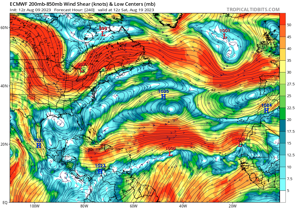
12Z Euro ramps up the shear at the end and likely why it is more strung out with no development compared to 00Z:

Image
0 likes   

User avatar
Spacecoast
Category 2
Category 2
Posts: 758
Joined: Thu Aug 31, 2017 2:03 pm

Re: 2023 Global Model Runs Discussion (Out thru day 16)

#783 Postby Spacecoast » Wed Aug 09, 2023 5:19 pm

GFS shows some shear also
Image
0 likes   

LarryWx
S2K Supporter
S2K Supporter
Posts: 6311
Joined: Sun Sep 07, 2003 2:04 pm
Location: GA

Re: 2023 Global Model Runs Discussion (Out thru day 16)

#784 Postby LarryWx » Wed Aug 09, 2023 6:53 pm

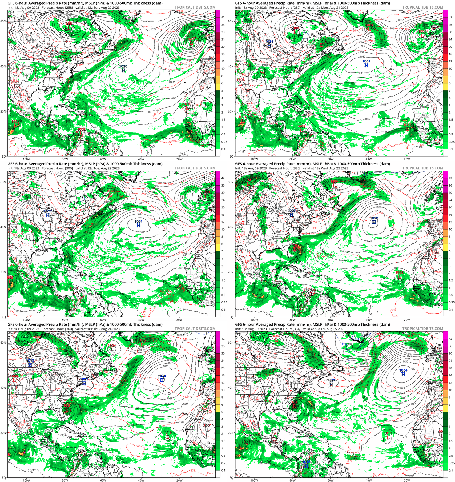
For the 40 GFS runs since July 31st, an unusually low 10% of them (four runs) have had a hurricane in the Atlantic basin at any point during the 384 hours (all have been within fantasy range) with the latest run being just the first Happy Hour run with one:

-7/31 12Z: hit SC 8/16
-8/3 6Z: hit MX/TX border 8/16
-8/6 0Z: MDR 8/18-21
-8/9 18Z: just off SC 8/25
2 likes   
Personal Forecast Disclaimer:
The posts in this forum are NOT official forecasts and should not be used as such. They are just the opinion of the poster and may or may not be backed by sound meteorological data. They are NOT endorsed by any professional institution or storm2k.org. For official information, please refer to the NHC and NWS products.

User avatar
Blown Away
S2K Supporter
S2K Supporter
Posts: 10147
Joined: Wed May 26, 2004 6:17 am

Re: 2023 Global Model Runs Discussion (Out thru day 16)

#785 Postby Blown Away » Wed Aug 09, 2023 7:07 pm

LarryWx wrote:For the 40 GFS runs since July 31st, an unusually low 10% of them (four runs) have had a hurricane in the Atlantic basin at any point during the 384 hours (all have been within fantasy range) with the latest run being just the first Happy Hour run with one:

-7/31 12Z: hit SC 8/16
-8/3 6Z: hit MX/TX border 8/16
-8/6 0Z: MDR 8/18-21
-8/9 18Z: just off SC 8/25


Image
2 likes   
Hurricane Eye Experience: David 79, Irene 99, Frances 04, Jeanne 04, Wilma 05... EYE COMING MY WAY IN 2024…
Hurricane Brush Experience: Andrew 92, Erin 95, Floyd 99, Matthew 16, Irma 17, Ian 22, Nicole 22…

User avatar
Spacecoast
Category 2
Category 2
Posts: 758
Joined: Thu Aug 31, 2017 2:03 pm

Re: 2023 Global Model Runs Discussion (Out thru day 16)

#786 Postby Spacecoast » Wed Aug 09, 2023 7:31 pm

LarryWx wrote:For the 40 GFS runs since July 31st, an unusually low 10% of them (four runs) have had a hurricane in the Atlantic basin at any point during the 384 hours (all have been within fantasy range) with the latest run being just the first Happy Hour run with one:

8-)
An unusually low number of 10%, compared to the usual number of xx %?

Meanwhile, the 18z GEFS run seems be running into some shear...
Image
1 likes   

LarryWx
S2K Supporter
S2K Supporter
Posts: 6311
Joined: Sun Sep 07, 2003 2:04 pm
Location: GA

Re: 2023 Global Model Runs Discussion (Out thru day 16)

#787 Postby LarryWx » Wed Aug 09, 2023 7:44 pm

Spacecoast wrote:
LarryWx wrote:For the 40 GFS runs since July 31st, an unusually low 10% of them (four runs) have had a hurricane in the Atlantic basin at any point during the 384 hours (all have been within fantasy range) with the latest run being just the first Happy Hour run with one:

8-)
An unusually low number of 10%, compared to the usual number of xx %?

Meanwhile, the 18z GEFS run seems be running into some shear...
https://i.ibb.co/jfs5MBd/ee8.jpg


I don't know the exact answer. Also, I should have been more specific and said that 10% is unusually low for runs during late July through August.
What would you and others guess is the % of runs with a H on it during then? My guess based on the past per my recollection is 2/3-3/4 of them at a minimum keeping in mind that a good number of those runs were modeling real hurricanes over a 16 day period, when the odds of at least one materializing are pretty high. Of course, some are missed, too. Due to the extreme quiet of August of 2022, the GFS may have had a similarly low % with hurricanes. But I'm talking overall.
1 likes   
Personal Forecast Disclaimer:
The posts in this forum are NOT official forecasts and should not be used as such. They are just the opinion of the poster and may or may not be backed by sound meteorological data. They are NOT endorsed by any professional institution or storm2k.org. For official information, please refer to the NHC and NWS products.

User avatar
Spacecoast
Category 2
Category 2
Posts: 758
Joined: Thu Aug 31, 2017 2:03 pm

Re: 2023 Global Model Runs Discussion (Out thru day 16)

#788 Postby Spacecoast » Wed Aug 09, 2023 7:56 pm

"What would you and others guess is the % of runs with a H on it during then?"
I would agree with 60-75%.
Image
Approx 40% real, 60% false

Source: Halperin et al Oct 2020 "A Comparison of Tropical Cyclone Genesis Forecast Verification from Three
Global Forecast System (GFS)"
GFS 1314: 2013–14 operational configuration
GFS 2015: 2015 GFS configuration
GFS 2016: 2016 GFS configuration
Last edited by Spacecoast on Wed Aug 09, 2023 9:36 pm, edited 1 time in total.
2 likes   

OuterBanker
S2K Supporter
S2K Supporter
Posts: 1731
Joined: Wed Feb 26, 2003 10:53 am
Location: Nags Head, NC
Contact:

Re: 2023 Global Model Runs Discussion (Out thru day 16)

#789 Postby OuterBanker » Wed Aug 09, 2023 9:07 pm

Spacecoast wrote:https://i.ibb.co/R2PZdHL/ee9.jpg
Approx 40% real, 60% false

Source: Halperin et al Oct 2020 "A Comparison of Tropical Cyclone Genesis Forecast Verification from Three
Global Forecast System (GFS)"


Wow, I didn't realize that the GFS went back all the way to 1314 :D
0 likes   

LarryWx
S2K Supporter
S2K Supporter
Posts: 6311
Joined: Sun Sep 07, 2003 2:04 pm
Location: GA

Re: 2023 Global Model Runs Discussion (Out thru day 16)

#790 Postby LarryWx » Wed Aug 09, 2023 11:57 pm

Spacecoast wrote:"What would you and others guess is the % of runs with a H on it during then?"
I would agree with 60-75%.
https://i.ibb.co/R2PZdHL/ee9.jpg
Approx 40% real, 60% false

Source: Halperin et al Oct 2020 "A Comparison of Tropical Cyclone Genesis Forecast Verification from Three
Global Forecast System (GFS)"
GFS 1314: 2013–14 operational configuration
GFS 2015: 2015 GFS configuration
GFS 2016: 2016 GFS configuration


Perhaps I overdid it with guessing 2/3 to 3/4 of GFS runs typically having a H. The reason is looking at 2021. But first here are the 7/31-8/9/2022 GFS runs I know had a H:

1. 8/1 6Z hits S TX after a W Car 8/9 TCG
2. 8/8 6Z forms in SW ATL 8/19 and skirts E coast 8/22-3
3. 8/8 18Z forms MDR 8/24

So, unless one was missed, 2022 was actually a tad quieter than the 10% of 2023 with only 3 of 40 runs (8%) with a H.

Next, I decided to look at a fairly active 2021. Although it had no NS 7/31-8/9, it did have these soon afterward when looking ahead:

-TD Fred form on 8/11 in the NE Caribbean and soon become a TS
-TD Grace form in MDR on 8/13 although not a H til the WCar 8/18

These are the known GFS 7/31-8/9/21 runs with a H (I could have missed a couple of others but hopefully not):

1. 8/1 6Z forms in MDR by 8/11 (Future Grace??)
2. 8/4 18Z 92L
3. 8/6 12Z forms 8/13 Bahamas and hits S FL (Future Fred?)
4. 8/7 0Z 93L MDR 8/11
5. 8/7 6Z 93L forms by 8/10 W MDR
6. 8/7 12Z 93L hits PR 8/13
7. 8/9 0Z 95L Caribbean/GOM
8. 8/9 12Z 95L forms 8/22 hits MX 8/23

So, assuming I missed none and despite it being pretty active when looking ahead, there were still only 8 out of 40 (20%) with GFS hurricanes. Even if missed, say, 5, that would still only make 13 of 40 or ~1/3. So, whereas I still think 10% is quiet for the GFS, it may not be as quiet relative to other seasons as I earlier thought although it is much quieter than it was in July.
2 likes   
Personal Forecast Disclaimer:
The posts in this forum are NOT official forecasts and should not be used as such. They are just the opinion of the poster and may or may not be backed by sound meteorological data. They are NOT endorsed by any professional institution or storm2k.org. For official information, please refer to the NHC and NWS products.

User avatar
cycloneye
Admin
Admin
Posts: 145379
Age: 68
Joined: Thu Oct 10, 2002 10:54 am
Location: San Juan, Puerto Rico

Re: 2023 Global Model Runs Discussion (Out thru day 16)

#791 Postby cycloneye » Thu Aug 10, 2023 4:42 am

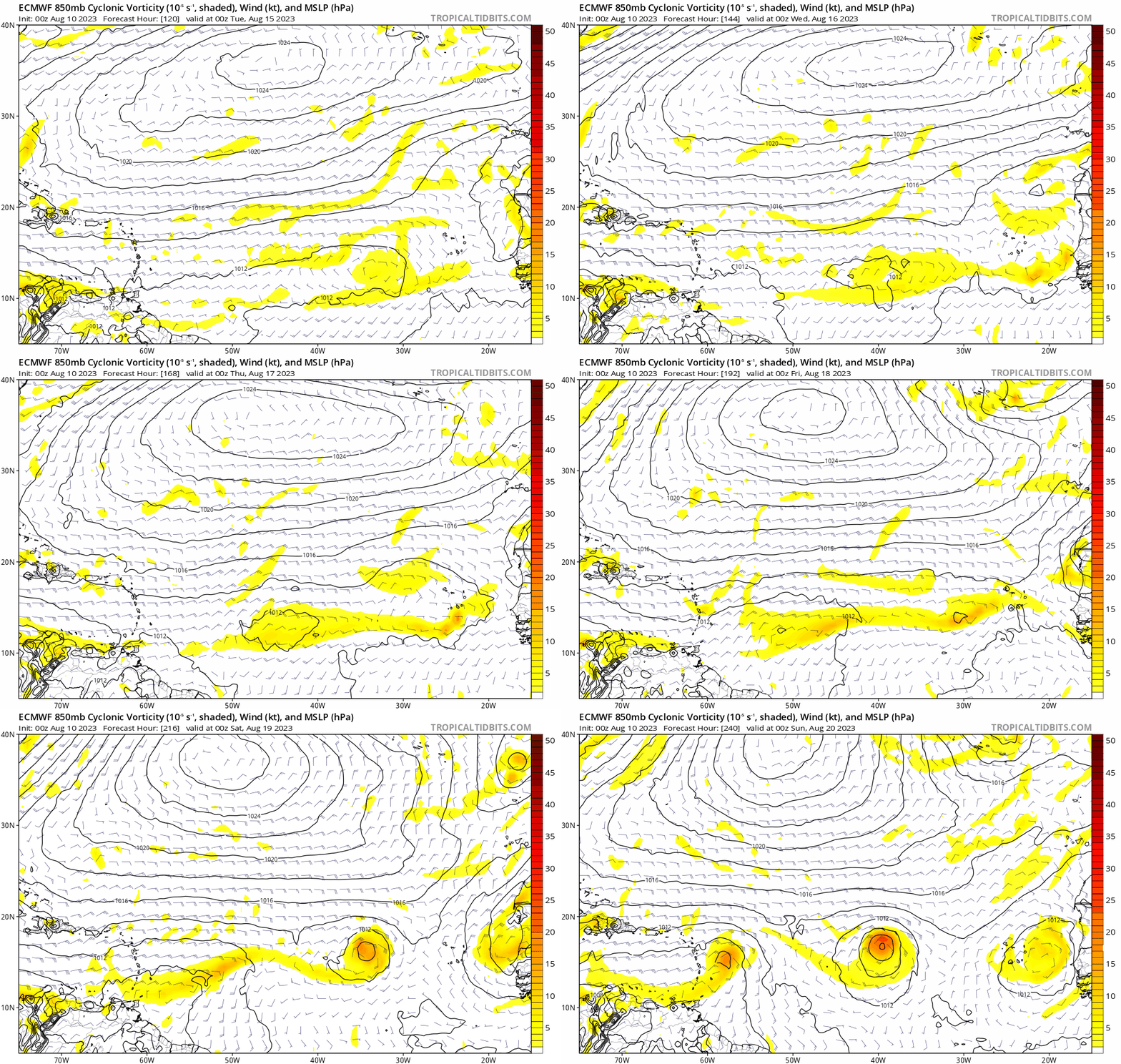
Surprised that the 00z Euro was not posted. It has two MDR posibilities.

Image
1 likes   
Visit the Caribbean-Central America Weather Thread where you can find at first post web cams,radars
and observations from Caribbean basin members Click Here

User avatar
SFLcane
S2K Supporter
S2K Supporter
Posts: 10163
Age: 47
Joined: Sat Jun 05, 2010 1:44 pm
Location: Lake Worth Florida

Re: 2023 Global Model Runs Discussion (Out thru day 16)

#792 Postby SFLcane » Thu Aug 10, 2023 5:09 am

cycloneye wrote:Surprised that the 00z Euro was not posted. It has two MDR posibilities.

https://i.imgur.com/C0QJPLJ.gif


Image
0 likes   

User avatar
Blown Away
S2K Supporter
S2K Supporter
Posts: 10147
Joined: Wed May 26, 2004 6:17 am

Re: 2023 Global Model Runs Discussion (Out thru day 16)

#793 Postby Blown Away » Thu Aug 10, 2023 5:12 am

cycloneye wrote:Surprised that the 00z Euro was not posted. It has two MDR posibilities.

https://i.imgur.com/C0QJPLJ.gif

Image
00z Euro
Image
00z CMC
Image
00z Icon
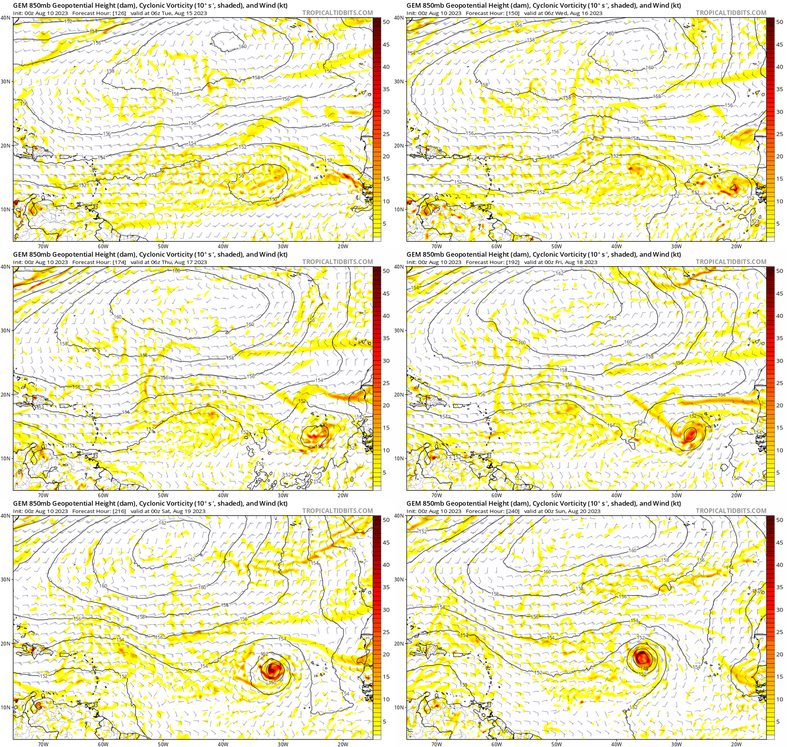
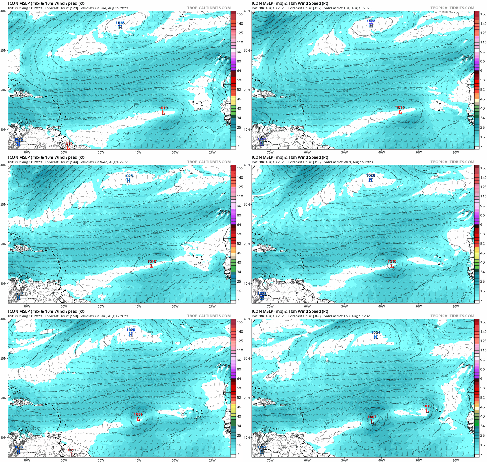
Yeah, 00z Euro vorticity/TS near the islands moving WNW into the Hebert Box. That pattern not good for NE Caribbean. Bahamas, and CONUS. Central Atlantic low is popping on all the models except the GFS. Activity starting on time again. :D
1 likes   
Hurricane Eye Experience: David 79, Irene 99, Frances 04, Jeanne 04, Wilma 05... EYE COMING MY WAY IN 2024…
Hurricane Brush Experience: Andrew 92, Erin 95, Floyd 99, Matthew 16, Irma 17, Ian 22, Nicole 22…

jlauderdal
S2K Supporter
S2K Supporter
Posts: 7183
Joined: Wed May 19, 2004 5:46 am
Location: NE Fort Lauderdale
Contact:

Re: 2023 Global Model Runs Discussion (Out thru day 16)

#794 Postby jlauderdal » Thu Aug 10, 2023 5:33 am

Blown Away wrote:
cycloneye wrote:Surprised that the 00z Euro was not posted. It has two MDR posibilities.

https://i.imgur.com/C0QJPLJ.gif

[url]https://i.postimg.cc/D0SGVrnJ/bb48ad03-a6bc-4343-b7bf-7c5384e3ba6a.gif [/url]
00z Euro
[url]https://i.postimg.cc/kggvwbtS/6fef0264-f6eb-4d5c-8d51-d0e8614a20d2.gif [/url]
00z CMC
[url]https://i.postimg.cc/j2zCzZXb/eb496926-591b-4453-af25-c2fa40f2cd9a.gif [/url]
00z Icon
Yeah, 00z Euro vorticity/TS near the islands moving WNW into the Hebert Box. That pattern not good for NE Caribbean. Bahamas, and CONUS. Central Atlantic low is popping on all the models except the GFS. Activity starting on time again. :D


Now we can spend days discussing the ridge instead of looking for vorticity on 300+ hour models....buckle up; plenty of available energy for the rest of the way; something over the next 60 days will be able to take advantage of the SST's; gulf looks really prime if something can get in there.
1 likes   

jlauderdal
S2K Supporter
S2K Supporter
Posts: 7183
Joined: Wed May 19, 2004 5:46 am
Location: NE Fort Lauderdale
Contact:

Re: 2023 Global Model Runs Discussion (Out thru day 16)

#795 Postby jlauderdal » Thu Aug 10, 2023 5:35 am

SFLcane wrote:
cycloneye wrote:Surprised that the 00z Euro was not posted. It has two MDR posibilities.

https://i.imgur.com/C0QJPLJ.gif


https://i.postimg.cc/qBmDVv5R/IMG-7400.png

Look at those members plowing into the ridge, i know its the ensembles, but still.
0 likes   

User avatar
SFLcane
S2K Supporter
S2K Supporter
Posts: 10163
Age: 47
Joined: Sat Jun 05, 2010 1:44 pm
Location: Lake Worth Florida

Re: 2023 Global Model Runs Discussion (Out thru day 16)

#796 Postby SFLcane » Thu Aug 10, 2023 5:48 am

jlauderdal wrote:
SFLcane wrote:
cycloneye wrote:Surprised that the 00z Euro was not posted. It has two MDR posibilities.

https://i.imgur.com/C0QJPLJ.gif


https://i.postimg.cc/qBmDVv5R/IMG-7400.png

Look at those members plowing into the ridge, i know its the ensembles, but still.


Thankfully for now majority recurve before 60w.
0 likes   

User avatar
Blown Away
S2K Supporter
S2K Supporter
Posts: 10147
Joined: Wed May 26, 2004 6:17 am

Re: 2023 Global Model Runs Discussion (Out thru day 16)

#797 Postby Blown Away » Thu Aug 10, 2023 7:25 am

SFLcane wrote:
jlauderdal wrote:

Look at those members plowing into the ridge, i know its the ensembles, but still.


Thankfully for now majority recurve before 60w.


Image
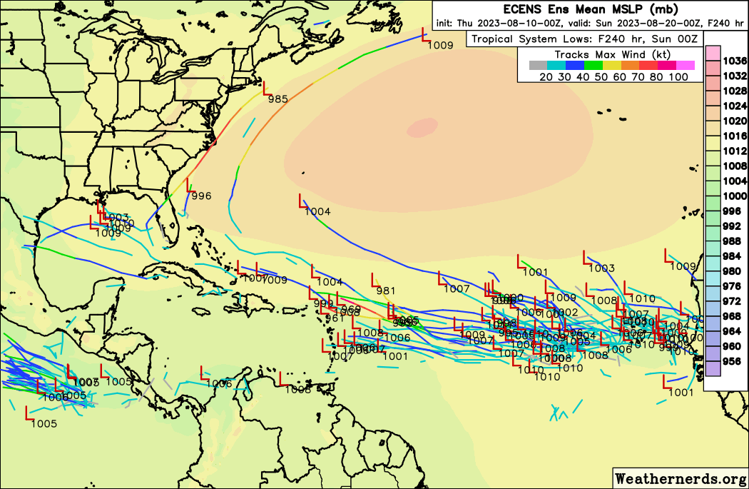
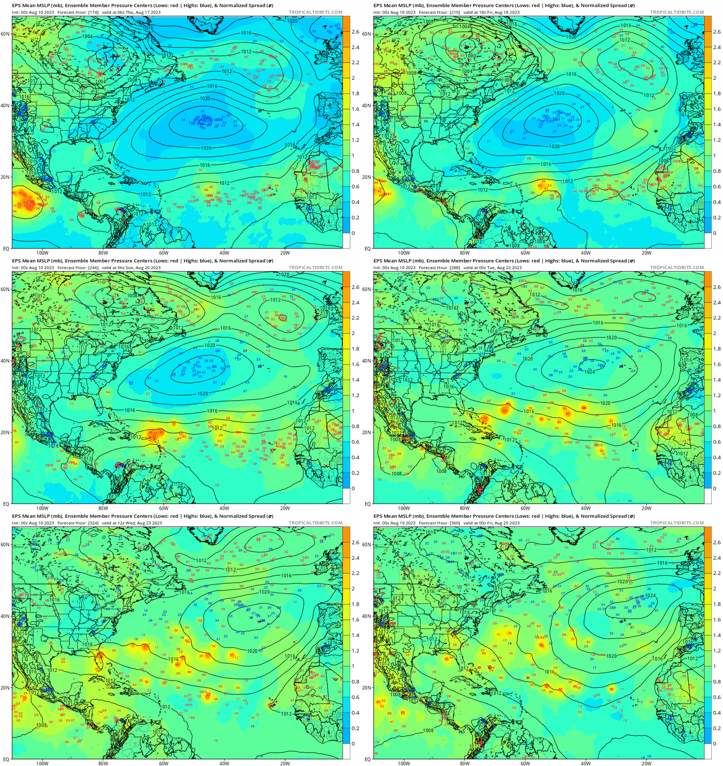
00z EPS... The 00z EURO TW near NE Caribbean in 10 days is the one that could impact points farther west, Euro only model showing development for this TW. Euro, Icon, CMC and GFS show a large TW in Central Atl in 10 days, that's the one that appears OTS.
0 likes   
Hurricane Eye Experience: David 79, Irene 99, Frances 04, Jeanne 04, Wilma 05... EYE COMING MY WAY IN 2024…
Hurricane Brush Experience: Andrew 92, Erin 95, Floyd 99, Matthew 16, Irma 17, Ian 22, Nicole 22…

LarryWx
S2K Supporter
S2K Supporter
Posts: 6311
Joined: Sun Sep 07, 2003 2:04 pm
Location: GA

Re: 2023 Global Model Runs Discussion (Out thru day 16)

#798 Postby LarryWx » Thu Aug 10, 2023 8:40 am

The various ensembles are suggesting E US ridging 8/21-4 followed by a hint of a trough moving in 8/25-6. That period as is often the case may be a risky one for the CONUS.
0 likes   
Personal Forecast Disclaimer:
The posts in this forum are NOT official forecasts and should not be used as such. They are just the opinion of the poster and may or may not be backed by sound meteorological data. They are NOT endorsed by any professional institution or storm2k.org. For official information, please refer to the NHC and NWS products.

User avatar
SFLcane
S2K Supporter
S2K Supporter
Posts: 10163
Age: 47
Joined: Sat Jun 05, 2010 1:44 pm
Location: Lake Worth Florida

Re: 2023 Global Model Runs Discussion (Out thru day 16)

#799 Postby SFLcane » Thu Aug 10, 2023 8:46 am

LarryWx wrote:The various ensembles are suggesting E US ridging 8/21-4 followed by a hint of a trough moving in 8/25-6. That period as is often the case may be a risky one for the CONUS.


Can you post?
0 likes   

Tailgater33
Tropical Depression
Tropical Depression
Posts: 88
Joined: Thu Jun 02, 2022 9:15 am

Re: 2023 Global Model Runs Discussion (Out thru day 16)

#800 Postby Tailgater33 » Thu Aug 10, 2023 8:48 am

As some of the models are suggesting I’m Hoping the little disturbed area entering the SE Bahamas/Eastern Cuba can bring a little pocket of moisture to south Louisiana or S/E Texas for some much needed rain, I’d take some heavy clouds at this point.
Last edited by Tailgater33 on Thu Aug 10, 2023 9:22 am, edited 1 time in total.
1 likes   


Return to “Talkin' Tropics”

Who is online

Users browsing this forum: cajungal, flstorms, JtSmarts, TomballEd and 36 guests