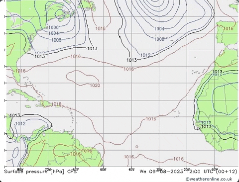
cycloneye wrote:The CPC hazards forecast has areas on weeks 2 and 3 in Western Atlantic and MDR.
https://i.imgur.com/SU37TzZ.png
Hi Luis, hmmm that's interesting right on cue to start cv season.
Moderator: S2k Moderators


cycloneye wrote:The CPC hazards forecast has areas on weeks 2 and 3 in Western Atlantic and MDR.
https://i.imgur.com/SU37TzZ.png
gatorcane wrote:LarryWx wrote:As mentioned, the 12Z GEFS has strong Caribbean shear starting August 12th. That continues for about a week but then decreases to near normal Aug 20-23 while the strong shear zone shifts just to the north of the Greater Antilles.
Meanwhile as SFLcane showed, E US 500 mb ridging takes over on this run 8/19-8/23, which if it were to verify would potentially open the door to the E US for anything that might be in the W Atlantic then. Hopefully that would be shortlived if it happens.
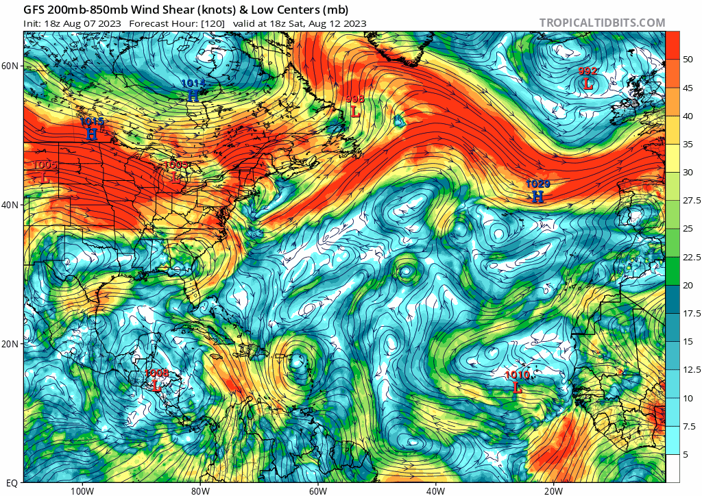
Yes indeed looks like quite a bit of shear. Here is the 18Z GFS animation from 120 to 258 hours. Maybe an early indicator of the El Niño shear which we could see later as we head into September and October across the Caribbean:
https://i.postimg.cc/0NxnYBWR/gfs-shear-atl-fh120-258.gif


WiscoWx02 wrote:gatorcane wrote:LarryWx wrote:As mentioned, the 12Z GEFS has strong Caribbean shear starting August 12th. That continues for about a week but then decreases to near normal Aug 20-23 while the strong shear zone shifts just to the north of the Greater Antilles.
Meanwhile as SFLcane showed, E US 500 mb ridging takes over on this run 8/19-8/23, which if it were to verify would potentially open the door to the E US for anything that might be in the W Atlantic then. Hopefully that would be shortlived if it happens.
Yes indeed looks like quite a bit of shear. Here is the 18Z GFS animation from 120 to 258 hours. Maybe an early indicator of the El Niño shear which we could see later as we head into September and October across the Caribbean:
https://i.postimg.cc/0NxnYBWR/gfs-shear-atl-fh120-258.gif
Reality is starting to set in that we are in an El Nino it seems. Ben Noll alludes to what is most likely in my opinion, a stunted Atlantic hurricane season. Ben Noll also agrees in one of his comment responses that warm SST’s aren’t likely to win the battle against subsidence and shear the Atlantic will be facing through peak season. We aren’t seeing El Nino’s full blown effects yet, but they seem to be just on the horizon.
Jr0d wrote:I noticed CAPE values above 3500 for Miami and Key West from last night's weather balloon sounding. I dont think I have ever seen higher values from weather balloon data. ( 0Z 8August23 )
https://weather.rap.ucar.edu/upper/


WiscoWx02 wrote:gatorcane wrote:LarryWx wrote:As mentioned, the 12Z GEFS has strong Caribbean shear starting August 12th. That continues for about a week but then decreases to near normal Aug 20-23 while the strong shear zone shifts just to the north of the Greater Antilles.
Meanwhile as SFLcane showed, E US 500 mb ridging takes over on this run 8/19-8/23, which if it were to verify would potentially open the door to the E US for anything that might be in the W Atlantic then. Hopefully that would be shortlived if it happens.
Yes indeed looks like quite a bit of shear. Here is the 18Z GFS animation from 120 to 258 hours. Maybe an early indicator of the El Niño shear which we could see later as we head into September and October across the Caribbean:
https://i.postimg.cc/0NxnYBWR/gfs-shear-atl-fh120-258.gif
Reality is starting to set in that we are in an El Nino it seems. Ben Noll alludes to what is most likely in my opinion, a stunted Atlantic hurricane season. Ben Noll also agrees in one of his comment responses that warm SST’s aren’t likely to win the battle against subsidence and shear the Atlantic will be facing through peak season. We aren’t seeing El Nino’s full blown effects yet, but they seem to be just on the horizon.
August angst for sure! I do love how consistent it is year after year. Another 10 days and everything starts to magically come to life. The climatology chart shows we are very much normal at the moment.tolakram wrote:WiscoWx02 wrote:gatorcane wrote:Yes indeed looks like quite a bit of shear. Here is the 18Z GFS animation from 120 to 258 hours. Maybe an early indicator of the El Niño shear which we could see later as we head into September and October across the Caribbean:
https://i.postimg.cc/0NxnYBWR/gfs-shear-atl-fh120-258.gif
Reality is starting to set in that we are in an El Nino it seems. Ben Noll alludes to what is most likely in my opinion, a stunted Atlantic hurricane season. Ben Noll also agrees in one of his comment responses that warm SST’s aren’t likely to win the battle against subsidence and shear the Atlantic will be facing through peak season. We aren’t seeing El Nino’s full blown effects yet, but they seem to be just on the horizon.
Looking at the long range GFS and believing what it says is a pretty risky bet. I don't see that anything has changed yet, except August angst.

Jr0d wrote:I have noticed that its like a switch turns on around August 15th- 20th. I tell people all the time the hurricane season doesn't really start to August 15th and many are confused are try to tell me it's June 1st like I didn't know. Maybe the NHC should declare August 15th thru October the "active hurricane season). 10 years ago I would hace thru October 15th...now I would call all of October active.
Like clock work the Ensembles are coming alive around August 20th...how would have guessed?

jlauderdal wrote:Jr0d wrote:I have noticed that its like a switch turns on around August 15th- 20th. I tell people all the time the hurricane season doesn't really start to August 15th and many are confused are try to tell me it's June 1st like I didn't know. Maybe the NHC should declare August 15th thru October the "active hurricane season). 10 years ago I would hace thru October 15th...now I would call all of October active.
Like clock work the Ensembles are coming alive around August 20th...how would have guessed?
Climatology is a pretty good indicator, look at the distribution of hurricanes over time
https://www.nhc.noaa.gov/climo/
October most active for Florida.
Meanwhile, its all about the heat for the time being.


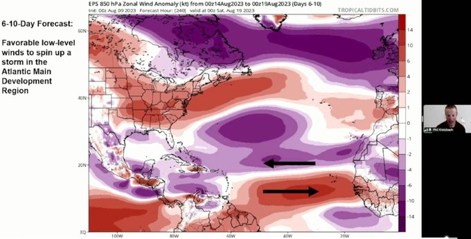
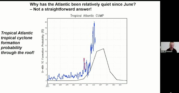
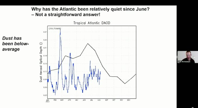

SFLcane wrote:Things should get going in about 6-10 days...
Very interesting chat with Phil k this morning.
https://i.postimg.cc/HnjsBkBt/jjj.png
cycloneye wrote:SFLcane wrote:Things should get going in about 6-10 days...
Very interesting chat with Phil k this morning.
https://i.postimg.cc/HnjsBkBt/jjj.png
Had things to do so did not hear it.. What were the highlights Adrian?

Ntxw wrote:One good lesson learned this early season is that hot SSTs do not necessarily translate to big activity. This is actively being shown in the Atlantic and EPAC of reverse effect. EPAC is generating ACE with normal to below normal SSTA (Dora) while Atlantic is dealing with dry air and unfavorable winds, regardless of SST. It's the atmosphere that really is the determining player.
Suspect activity may pick up in the Atlantic once the hemispheric pattern cools and breaks down the stagnant trough-ridge pattern in the mid latitudes.
Users browsing this forum: No registered users and 31 guests


