WPAC: DORA - Post-Tropical - Discussion
Moderator: S2k Moderators
-
Kingarabian

- S2K Supporter

- Posts: 16348
- Joined: Sat Aug 08, 2009 3:06 am
- Location: Honolulu, Hawaii
Re: EPAC: DORA - Tropical Storm - Discussion
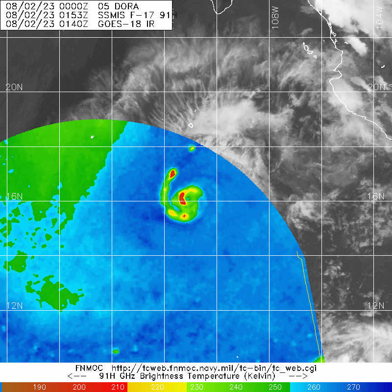
Is a hurricane for sure, probably has been one for the past 6hrs or so. IR structure has detoriated some though.
0 likes
RIP Kobe Bryant
-
Yellow Evan

- Professional-Met

- Posts: 16231
- Age: 27
- Joined: Fri Jul 15, 2011 12:48 pm
- Location: Henderson, Nevada/Honolulu, HI
- Contact:
Re: EPAC: DORA - Tropical Storm - Discussion: 00z Best Track up to Hurricane at 65 kt
* GFS version *
* EAST PACIFIC 2023 SHIPS INTENSITY FORECAST *
* IR SAT DATA AVAILABLE, OHC AVAILABLE *
* DORA EP052023 08/02/23 00 UTC *
TIME (HR) 0 6 12 18 24 36 48 60 72 84 96 108 120 132 144 156 168
V (KT) NO LAND 65 73 80 86 91 96 95 95 91 89 85 88 88 87 85 84 81
V (KT) LAND 65 73 80 86 91 96 95 95 91 89 85 88 88 87 85 84 81
V (KT) LGEM 65 74 81 87 93 101 102 101 98 97 97 97 96 92 88 86 85
Storm Type TROP TROP TROP TROP TROP TROP TROP TROP TROP TROP TROP TROP TROP TROP TROP TROP TROP
SHEAR (KT) 8 2 4 7 10 14 14 10 13 4 3 4 6 5 3 3 8
SHEAR ADJ (KT) -6 1 0 -3 -4 -1 -3 -1 -3 0 2 2 5 2 3 5 1
SHEAR DIR 153 94 78 41 60 71 86 87 83 139 309 308 73 97 56 334 2
SST (C) 29.7 29.5 29.2 29.1 29.0 28.6 27.0 27.5 26.6 26.9 26.6 26.8 27.1 27.1 26.7 26.9 27.0
POT. INT. (KT) 164 161 158 157 156 152 136 141 132 135 132 134 136 137 132 135 135
200 MB T (C) -50.8 -50.9 -50.9 -50.9 -50.8 -51.2 -50.8 -51.5 -51.3 -52.0 -51.7 -52.3 -52.2 -52.5 -52.4 -52.6 -52.3
200 MB VXT (C) 0.3 0.5 0.4 0.4 0.5 0.7 0.7 1.0 0.7 0.6 0.3 0.4 0.3 0.1 -0.1 0.0 0.0
TH_E DEV (C) 7 7 6 6 6 5 5 4 4 4 4 4 4 4 4 4 5
700-500 MB RH 59 58 58 58 58 56 55 57 55 57 58 62 61 57 48 45 45
MODEL VTX (KT) 13 11 13 15 15 16 15 18 18 19 17 20 19 18 16 14 12
850 MB ENV VOR 5 8 10 16 19 30 57 69 78 73 63 69 79 84 73 49 20
200 MB DIV 3 -11 -15 -1 -13 -34 -61 -55 25 11 -4 -10 -6 -16 3 -3 -17
700-850 TADV 1 -3 -3 -2 -2 0 1 -2 0 1 -3 -4 -3 -3 -3 -1 0
LAND (KM) 708 783 840 932 1036 1298 1554 1824 2094 2362 2224 1932 1691 1399 1115 895 787
LAT (DEG N) 16.2 16.2 16.2 16.0 15.8 15.3 14.9 14.3 13.8 13.5 13.2 12.8 12.4 xx.x xx.x xx.x xx.x
LONG(DEG W) 110.8 112.3 113.7 115.1 116.4 119.4 122.6 125.5 128.6 131.8 135.0 138.1 140.8 xxx.x xxx.x xxx.x xxx.x
STM SPEED (KT) 14 14 13 13 14 15 15 15 15 16 15 15 14 15 15 15 13
HEAT CONTENT 28 21 17 18 18 18 3 12 1 2 8 7 16 4 4 3 3
FORECAST TRACK FROM OFCI INITIAL HEADING/SPEED (DEG/KT):275/ 14 CX,CY: -13/ 1
T-12 MAX WIND: 45 PRESSURE OF STEERING LEVEL (MB): 522 (MEAN=588)
GOES IR BRIGHTNESS TEMP. STD DEV. 50-200 KM RAD: 7.7 (MEAN=14.5)
% GOES IR PIXELS WITH T < -20 C 50-200 KM RAD: 96.0 (MEAN=65.0)
PRELIM RI PROB (DV .GE. 35 KT IN 36 HR): 39.2
INDIVIDUAL CONTRIBUTIONS TO INTENSITY CHANGE
6 12 18 24 36 48 60 72 84 96 108 120 132 144 156 168
--------------------------------------------------------------------------------------------
SAMPLE MEAN CHANGE 0. 1. 1. 1. 1. 2. 2. 1. 1. -0. -1. -1. -2. -3. -3. -4.
SST POTENTIAL 1. 3. 4. 6. 8. 9. 10. 12. 12. 13. 14. 15. 14. 14. 14. 13.
VERTICAL SHEAR MAG 0. 1. 1. 1. 1. -0. 0. 0. 1. 4. 5. 6. 7. 9. 11. 12.
VERTICAL SHEAR ADJ 0. 0. 1. 1. 2. 2. 2. 2. 1. 1. 0. 0. 0. 0. 0. 0.
VERTICAL SHEAR DIR 0. 0. 1. 1. 3. 4. 5. 6. 6. 5. 3. 3. 3. 2. 1. 0.
PERSISTENCE 4. 6. 7. 7. 5. 4. 3. 2. 1. 1. 1. 1. 1. 1. 1. 1.
200/250 MB TEMP. -0. -0. -1. -1. -1. -1. -0. -0. -0. 0. 1. 1. 2. 2. 1. 1.
THETA_E EXCESS 0. 0. 0. 0. 0. -0. -1. -1. -2. -2. -2. -2. -2. -2. -2. -2.
700-500 MB RH -0. -0. -0. -0. -0. -0. -0. -1. -1. -0. -0. -0. -0. -0. -0. -0.
MODEL VTX TENDENCY -0. 0. 1. 2. 3. 2. 6. 7. 8. 5. 8. 6. 5. 2. 1. -1.
850 MB ENV VORTICITY -0. -0. -0. -0. -0. -0. -0. -0. -0. -0. -0. -0. -1. -1. -1. -0.
200 MB DIVERGENCE -0. -0. -0. -1. -1. -1. -3. -4. -4. -4. -3. -2. -1. 0. 1. 1.
850-700 T ADVEC 0. 0. 0. 0. 0. 0. 0. 0. 0. 0. 0. -0. -0. -0. -0. -1.
ZONAL STORM MOTION 0. -0. -0. -0. 0. 0. 0. -0. -0. -0. -1. -0. -1. -1. -2. -3.
STEERING LEVEL PRES -0. -0. -0. -0. -1. -1. -1. -1. -1. -1. -1. -2. -1. -1. -1. -0.
DAYS FROM CLIM. PEAK 0. 0. 0. 0. 0. 0. 0. 0. 0. 0. 1. 1. 1. 1. 1. 1.
GOES PREDICTORS 1. 2. 2. 2. 2. 2. 2. 2. 2. 2. 3. 3. 3. 2. 2. 2.
OCEAN HEAT CONTENT -0. -0. -0. -0. -0. -0. -0. -0. 0. 0. 0. 0. 0. 1. 1. 2.
RI POTENTIAL 1. 2. 4. 6. 10. 9. 5. 1. -1. -3. -5. -5. -5. -5. -5. -5.
--------------------------------------------------------------------------------------------
TOTAL CHANGE 8. 15. 21. 26. 31. 30. 30. 26. 24. 20. 23. 23. 22. 20. 19. 16.
CURRENT MAX WIND (KT): 65. LAT, LON: 16.2 110.8
** 2023 E. PACIFIC RI INDEX EP052023 DORA 08/02/23 00 UTC **
(SHIPS-RII PREDICTOR TABLE for 30 KT OR MORE MAXIMUM WIND INCREASE IN NEXT 24-h)
Predictor Value RI Predictor Range Scaled Value(0-1) % Contribution
POT = MPI-VMAX (KT) : 94.3 36.9 to 148.5 0.51 14.4
12 HR PERSISTENCE (KT) : 20.0 -22.0 to 44.0 0.64 15.4
MULTI-LAYER SHEAR (KT) : 14.1 30.9 to 7.7 0.73 13.8
BL DRY-AIR FLUX (W/M2) : 392.4 816.2 to -81.4 0.47 -10.2
D200 (10**7s-1) : -7.4 -33.0 to 159.5 0.13 2.2
MAXIMUM WIND (KT) : 65.0 22.5 to 132.0 0.90 14.6
STD DEV OF IR BR TEMP : 7.7 37.8 to 2.1 0.84 11.3
HEAT CONTENT (KJ/CM2) : 20.4 2.7 to 103.4 0.18 1.4
%area of TPW <45 mm upshear : 0.0 49.8 to 0.0 1.00 5.2
2nd PC OF IR BR TEMP : -0.5 2.2 to -2.3 0.62 0.2
SHIPS Prob RI for 20kt/ 12hr RI threshold= 67% is 10.7 times climatological mean ( 6.3%)
SHIPS Prob RI for 25kt/ 24hr RI threshold= 71% is 5.3 times climatological mean (12.5%)
SHIPS Prob RI for 30kt/ 24hr RI threshold= 68% is 8.1 times climatological mean ( 8.6%)
SHIPS Prob RI for 35kt/ 24hr RI threshold= 67% is 11.6 times climatological mean ( 6.2%)
SHIPS Prob RI for 40kt/ 24hr RI threshold= 56% is 13.4 times climatological mean ( 4.2%)
SHIPS Prob RI for 45kt/ 36hr RI threshold= 40% is 6.0 times climatological mean ( 6.7%)
SHIPS Prob RI for 55kt/ 48hr RI threshold= 0% is 0.0 times climatological mean ( 5.9%)
SHIPS Prob RI for 65kt/ 72hr RI threshold= 0% is 0.0 times climatological mean ( 4.7%)
Matrix of RI probabilities
------------------------------------------------------------------------------
RI (kt / h) | 20/12 | 25/24 | 30/24 | 35/24 | 40/24 | 45/36 | 55/48 |65/72
------------------------------------------------------------------------------
SHIPS-RII: 67.2% 70.5% 68.3% 67.3% 56.2% 39.9% 0.0% 0.0%
Logistic: 40.8% 43.1% 34.2% 24.4% 24.0% 4.5% 0.8% 3.6%
Bayesian: 3.3% 14.3% 1.3% 0.6% 2.0% 0.6% 0.0% 0.0%
Consensus: 37.1% 42.6% 34.6% 30.8% 27.4% 15.0% 0.3% 1.2%
DTOPS: 60.0% 69.0% 60.0% 47.0% 29.0% 55.0% 31.0% 2.0%
## ANNULAR HURRICANE INDEX (AHI) EP052023 DORA 08/02/23 00 UTC ##
## STORM NOT ANNULAR, SCREENING STEP FAILED, NPASS=3 NFAIL=4 ##
## AHI= 0 (AHI OF 100 IS BEST FIT TO ANN. STRUC., 1 IS MARGINAL, 0 IS NOT ANNULAR) ##
0 likes
-
ElectricStorm

- Category 5

- Posts: 5140
- Age: 25
- Joined: Tue Aug 13, 2019 11:23 pm
- Location: Norman, OK
Re: EPAC: DORA - Tropical Storm - Discussion: 00z Best Track up to Hurricane at 65 kt
UW - CIMSS
ADVANCED DVORAK TECHNIQUE
ADT-Version 9.1
Tropical Cyclone Intensity Algorithm
----- Current Analysis -----
Date : 02 AUG 2023 Time : 004021 UTC
Lat : 16:06:21 N Lon : 110:59:32 W
CI# /Pressure/ Vmax
4.5 / 980.2mb/ 77.0kt
Final T# Adj T# Raw T#
4.5 4.5 4.5
Center Temp : -64.5C Cloud Region Temp : -66.1C
Scene Type : EMBEDDED CENTER CLOUD REGION w/ MW EYE
Subtropical Adjustment : OFF
Extratropical Adjustment : OFF
Positioning Method : FORECAST INTERPOLATION
Ocean Basin : EAST PACIFIC
Dvorak CI > MSLP Conversion Used : CKZ Method
Tno/CI Rules : Constraint Limits : MW ON
Weakening Flag : OFF
Rapid Dissipation Flag : OFF
C/K/Z MSLP Estimate Inputs :
- Average 34 knot radii : 27nmi
- Environmental MSLP : 1012mb
Satellite Name : GOES18
Satellite Viewing Angle : 35.3 degrees
0 likes
B.S Meteorology, University of Oklahoma '25
Please refer to the NHC, NWS, or SPC for official information.
Please refer to the NHC, NWS, or SPC for official information.
-
Sciencerocks
- Category 5
- Posts: 10181
- Age: 40
- Joined: Thu Jul 06, 2017 1:51 am

-
cycloneye

- Admin

- Posts: 149275
- Age: 69
- Joined: Thu Oct 10, 2002 10:54 am
- Location: San Juan, Puerto Rico
Re: EPAC: DORA - Hurricane - Discussion
Hurricane Dora Discussion Number 6
NWS National Hurricane Center Miami FL EP052023
500 PM HST Tue Aug 01 2023
Dora continues to improve structurally on GOES 1-min satellite, and
microwave imagery. An earlier AMSR microwave pass showed that Dora
has developed a tight inner core with a convective band wrapping
entirely around the center. The 36GHz microwave channel and visible
satellite also depict what probably is the developmental stages of a
tiny eye. Deep convection has persisted over the center, with cold
cloud tops throughout the afternoon. Subjective intensity estimates
from SAB and TAFB were T3.5 and T4.0, respectively. Objective
estimates from CIMMS AiDT and ADT range from 64 to 75 knots. Given
the improved satellite trends, system structure and a blend of the
various satellite estimates, the initial intensity is raised to 65
kt for this advisory. This makes Dora the fourth hurricane of the
eastern Pacific hurricane season.
The hurricane continues to move westward with a motion at 270/14 kt.
There is not much change in the track forecast as guidance continues
to be in good agreement. The large mid-level ridge north of the
system is expected to build north-northwest, which will steer Dora
westward with a gradual turn to the west-southwest tomorrow through
the end of the forecast period. The latest NHC track forecast is
very similar to the previous one, and lies near the consensus aids.
Dora is rapidly intensifying this afternoon, with an increase of 35
kt the last 24 hours. Vertical wind shear remains low and
sea-surface temperatures are very warm for the next 36 hours, so
rapid intensification is forecast to continue during that time,
which is supported by the latest SHIPS-RII guidance from both the
ECMWF and GFS. The intensity forecast lies near the corrected
consensus guidance, HCCA, through the next 72 hours. Afterwards,
SSTs begin to drop down to 27 C and an increase in easterly shear
may lead to some gradual weakening. The intensity guidance this
cycle was much lower than the previous from 72 hours through the end
of the forecast period, and thus the intensity guidance was lowered
slightly through 120 hrs. The NHC forecast intensity is still higher
than the consensus aids during this time frame, which showed further
weakening.
FORECAST POSITIONS AND MAX WINDS
INIT 02/0300Z 16.2N 111.5W 65 KT 75 MPH
12H 02/1200Z 16.1N 113.7W 80 KT 90 MPH
24H 03/0000Z 15.8N 116.4W 95 KT 110 MPH
36H 03/1200Z 15.5N 119.3W 110 KT 125 MPH
48H 04/0000Z 15.0N 122.3W 105 KT 120 MPH
60H 04/1200Z 14.4N 125.5W 100 KT 115 MPH
72H 05/0000Z 14.0N 128.7W 95 KT 110 MPH
96H 06/0000Z 13.1N 134.9W 85 KT 100 MPH
120H 07/0000Z 12.7N 140.8W 80 KT 90 MPH
$$
Forecaster Kelly/Blake
0 likes
Visit the Caribbean-Central America Weather Thread where you can find at first post web cams,radars
and observations from Caribbean basin members Click Here
and observations from Caribbean basin members Click Here
-
Kingarabian
- S2K Supporter
- Posts: 16348
- Joined: Sat Aug 08, 2009 3:06 am
- Location: Honolulu, Hawaii
Re: EPAC: DORA - Hurricane - Discussion
Looks like it's still mixing out dry air.
0 likes
RIP Kobe Bryant
-
Sciencerocks
- Category 5
- Posts: 10181
- Age: 40
- Joined: Thu Jul 06, 2017 1:51 am

Re: EPAC: DORA - Hurricane - Discussion
Given the latest convective bursts, looks like dry air issues have been sorted out:
0 likes
TC naming lists: retirements and intensity
Most aggressive Advisory #1's in North Atlantic (cr. kevin for starting the list)
Most aggressive Advisory #1's in North Atlantic (cr. kevin for starting the list)
-
Yellow Evan
- Professional-Met
- Posts: 16231
- Age: 27
- Joined: Fri Jul 15, 2011 12:48 pm
- Location: Henderson, Nevada/Honolulu, HI
- Contact:
Re: EPAC: DORA - Hurricane - Discussion

This is rotating from downshear to upshear super fast. Once it makes it downshear, I expect an eye to try to clear. If nothing (ie dry air) interrupts it, major hurricane within 12-15 hours.
Also of note is a ULAC to the NE ventilating the system especially its poleward outflow channel.
0 likes
-
Sciencerocks
- Category 5
- Posts: 10181
- Age: 40
- Joined: Thu Jul 06, 2017 1:51 am

-
Extratropical94

- Professional-Met
- Posts: 3545
- Age: 31
- Joined: Wed Oct 20, 2010 6:36 am
- Location: Hamburg, Germany
- Contact:
Re: EPAC: DORA - Hurricane - Discussion
EP, 05, 2023080206, , BEST, 0, 159N, 1119W, 80, 985, HU
80 knots, that’s a 45kt increase in 24 hours.
0 likes
54° 11' 59'' N, 9° 9' 20'' E
Boomer Sooner!
Go Broncos! Go Cards!
Clinching counties, one at a time: https://mob-rule.com/user-gifs/USA/xtrp94.gif
- Daniel
Boomer Sooner!
Go Broncos! Go Cards!
Clinching counties, one at a time: https://mob-rule.com/user-gifs/USA/xtrp94.gif
- Daniel
-
cycloneye
- Admin
- Posts: 149275
- Age: 69
- Joined: Thu Oct 10, 2002 10:54 am
- Location: San Juan, Puerto Rico
Re: EPAC: DORA - Hurricane - Discussion
Hurricane Dora Discussion Number 7
NWS National Hurricane Center Miami FL EP052023
1100 PM HST Tue Aug 01 2023
Dora is still rapidly intensifying and is well on its way to
becoming a major hurricane. An eye is apparent in microwave
imagery and is beginning to show up in geostationary images as well.
The current intensity has been boosted to 80 kt in agreement with
the latest objective and subjective Dvorak estimates, which is an
increase of about 45 kt over the past 24 hours. The system remains
quite small, with a radius of maximum winds of 10 n mi or even less.
The cirrus-level outflow pattern is quite symmetric and well
defined.
Dora has been moving just slightly south of due west, or about
260/14 kt. A 500 mb ridge is well established to the north of the
hurricane, and global model guidance indicates that the ridge
should build westward over the next couple of days. This steering
scenario should result in a continued westward to
west-southwestward motion over most of the forecast period. The
NHC track forecast lies between the latest simple and corrected
consensus, TVCE and HCCA, guidance and is near or just a bit south
of the previous official forecast.
The hurricane is moving over ocean waters with SSTs above 29 deg C
and in an environment of weak vertical wind shear. All
indications are that the rapid intensification (RI) episode should
continue for at least the next 24 hours. This is supported by the
various RI indices, for example the Deterministic to Probabilistic
Statistical Model (DTOPS) which shows a 63 percent chance of RI for
today. One complicating factor for the intensity forecast is a
possible eyewall replacement cycle which could slow Dora's rate of
strengthening. In 48 hours or so, some increase in easterly shear
and a cooler waters are expected to induce gradual weakening. The
official intensity forecast is generally near the high end of the
model guidance.
FORECAST POSITIONS AND MAX WINDS
INIT 02/0900Z 15.8N 112.6W 80 KT 90 MPH
12H 02/1800Z 15.7N 114.6W 95 KT 110 MPH
24H 03/0600Z 15.4N 117.4W 110 KT 125 MPH
36H 03/1800Z 14.8N 120.5W 110 KT 125 MPH
48H 04/0600Z 14.4N 123.5W 100 KT 115 MPH
60H 04/1800Z 14.0N 126.8W 90 KT 105 MPH
72H 05/0600Z 13.5N 130.0W 85 KT 100 MPH
96H 06/0600Z 12.9N 136.2W 80 KT 90 MPH
120H 07/0600Z 12.7N 142.6W 75 KT 85 MPH
$$
Forecaster Pasch
0 likes
Visit the Caribbean-Central America Weather Thread where you can find at first post web cams,radars
and observations from Caribbean basin members Click Here
and observations from Caribbean basin members Click Here
-
ElectricStorm
- Category 5
- Posts: 5140
- Age: 25
- Joined: Tue Aug 13, 2019 11:23 pm
- Location: Norman, OK
Re: EPAC: DORA - Hurricane - Discussion
Eye starting to appear on IR with new towers going up around the center. Well on its way to a major
0 likes
B.S Meteorology, University of Oklahoma '25
Please refer to the NHC, NWS, or SPC for official information.
Please refer to the NHC, NWS, or SPC for official information.
-
cycloneye
- Admin
- Posts: 149275
- Age: 69
- Joined: Thu Oct 10, 2002 10:54 am
- Location: San Juan, Puerto Rico
Re: EPAC: DORA - Hurricane - Discussion
EP, 05, 2023080212, , BEST, 0, 157N, 1135W, 90, 977, HU
0 likes
Visit the Caribbean-Central America Weather Thread where you can find at first post web cams,radars
and observations from Caribbean basin members Click Here
and observations from Caribbean basin members Click Here


Re: EPAC: DORA - Hurricane - Discussion
Once it can warm and clear the eye, this probably will make it cat 4.
0 likes
The above post and any post by Ntxw is NOT an official forecast and should not be used as such. It is just the opinion of the poster and may or may not be backed by sound meteorological data. It is NOT endorsed by any professional institution including Storm2k. For official information, please refer to NWS products.
Help support Storm2K!

-
cycloneye
- Admin
- Posts: 149275
- Age: 69
- Joined: Thu Oct 10, 2002 10:54 am
- Location: San Juan, Puerto Rico
Re: EPAC: DORA - Hurricane - Discussion

0 likes
Visit the Caribbean-Central America Weather Thread where you can find at first post web cams,radars
and observations from Caribbean basin members Click Here
and observations from Caribbean basin members Click Here
-
cheezyWXguy

- Category 5
- Posts: 6281
- Joined: Mon Feb 13, 2006 12:29 am
- Location: Dallas, TX
Re: EPAC: DORA - Hurricane - Discussion
Ntxw wrote:Once it can warm and clear the eye, this probably will make it cat 4.
Agreed. With an eye and core that small would expect continued RI as long as it remains unimpeded
0 likes
-
wxman57

- Moderator-Pro Met

- Posts: 23172
- Age: 68
- Joined: Sat Jun 21, 2003 8:06 pm
- Location: Houston, TX (southwest)
Re: EPAC: DORA - Hurricane - Discussion
Dvorak isn't taking into consideration the pinhole eye. It may already a Cat 4. Fortunately, it will not be any threat to Hawaii, as the ridge to its north is rather strong.
1 likes
-
cycloneye
- Admin
- Posts: 149275
- Age: 69
- Joined: Thu Oct 10, 2002 10:54 am
- Location: San Juan, Puerto Rico
Re: EPAC: DORA - Hurricane - Discussion
BULLETIN
Hurricane Dora Advisory Number 8
NWS National Hurricane Center Miami FL EP052023
500 AM HST Wed Aug 02 2023
...SMALL DORA CONTINUES RAPIDLY INTENSIFYING...
SUMMARY OF 500 AM HST...1500 UTC...INFORMATION
----------------------------------------------
LOCATION...15.6N 114.2W
ABOUT 575 MI...930 KM SSW OF THE SOUTHERN TIP OF BAJA CALIFORNIA
MAXIMUM SUSTAINED WINDS...105 MPH...165 KM/H
PRESENT MOVEMENT...W OR 260 DEGREES AT 16 MPH...26 KM/H
MINIMUM CENTRAL PRESSURE...977 MB...28.85 INCHES
Hurricane Dora Discussion Number 8
NWS National Hurricane Center Miami FL EP052023
500 AM HST Wed Aug 02 2023
Dora continues to rapidly intensify this morning. Overnight infrared
and first-light visible satellite imagery indicates that Dora has a
small but tight inner core, with a pinhole eye starting to emerge
from the central dense overcast cirrus. An AMSR2 microwave pass at
850 UTC showed this tiny core structure well, though some residual
dry air was still noted between the inner core and the curved
banding on Dora's west side. Subjective Dvorak intensity estimates
were T5.0/90 kt from TAFB and T4.5/77 kt form SAB, while the latest
objective ADT estimate was 84 kt. Given the improvement in structure
on satellite imagery since 1200 UTC, the initial intensity this
advisory is set at 90 kt, on the higher end of those estimates.
Dora continues to move just south of due west, at about 260/14 kt.
The track reasoning has not changed much over the past day, with a
well-established deep-layer ridge to the north of Dora expected to
steer the system westward to west-southwestward for most of the
forecast period. The latest NHC track continues to blend the simple
and corrected consensus aids (TVCE and HCCA), and is nearly on top
of the previous forecast track, if just a bit faster at the end of
the forecast period.
Dora is in the middle of a rapid intensification (RI) cycle, and
most of the guidance suggests that RI should continue for the next
12-24 h or so. Thus, the intensity forecast in the short-term was
raised again, now showing a peak of 115 kt in 24 h. This intensity
is just a little higher than the HCCA and IVCN consensus aids, but
remains lower than the latest HAFS-A/B guidance. Afterwards, Dora's
small inner core could begin to undergo structural changes, such as
an eyewall replacement cycle. GFS-SHIPS guidance also shows easterly
shear increasing over the system as sea-surface temperatures
gradually decrease down to 27 C. A combo of these factors should
result in some gradual weakening, which is reflected in the latest
NHC intensity forecast beginning at 36 h, following the consensus
aids most closely. However, the small size of Dora could make the
system prone to more rapid intensity changes than reflected here.
FORECAST POSITIONS AND MAX WINDS
INIT 02/1500Z 15.6N 114.2W 90 KT 105 MPH
12H 03/0000Z 15.4N 116.4W 105 KT 120 MPH
24H 03/1200Z 15.0N 119.3W 115 KT 130 MPH
36H 04/0000Z 14.6N 122.3W 110 KT 125 MPH
48H 04/1200Z 14.1N 125.4W 95 KT 110 MPH
60H 05/0000Z 13.7N 128.6W 85 KT 100 MPH
72H 05/1200Z 13.3N 131.8W 80 KT 90 MPH
96H 06/1200Z 12.7N 138.4W 80 KT 90 MPH
120H 07/1200Z 12.5N 145.0W 75 KT 85 MPH
$$
Forecaster Papin
0 likes
Visit the Caribbean-Central America Weather Thread where you can find at first post web cams,radars
and observations from Caribbean basin members Click Here
and observations from Caribbean basin members Click Here
-
Kingarabian
- S2K Supporter
- Posts: 16348
- Joined: Sat Aug 08, 2009 3:06 am
- Location: Honolulu, Hawaii
Re: EPAC: DORA - Hurricane - Discussion
That AMSR2 pass is about 6 hours old. While it is mixing in/out dry air it appears to be moving away from a curved band and getting that buzzsaw look. A buzzsaw hurricane while moving west in this area of the EPAC generally means a high end Cat.4 is very possible. Also slight increase in easterly shear decrease in SSTs won't impede this.
0 likes
RIP Kobe Bryant
Who is online
Users browsing this forum: No registered users and 27 guests