2023 Indicators (SST, SAL, MSLP, Wind shear, Steering, Instability) and Day 16+ Models
Moderator: S2k Moderators
Forum rules

The posts in this forum are NOT official forecasts and should not be used as such. They are just the opinion of the poster and may or may not be backed by sound meteorological data. They are NOT endorsed by any professional institution or STORM2K. For official information, please refer to products from the National Hurricane Center and National Weather Service.
Re: 2023 Indicators (SST, SAL, MSLP, Wind shear, Steering, Instability) and Day 16+ Models
Although not at all reliable, especially further out in time, I wonder if the 5 or so closed sfc lows the 0Z CFS shows in the MDR Aug 10-30th is an ominous sign of an active period then. Not many seasons actually have more activity than that during that period. Many recent CFS runs have been active in the MDR then along with one or so threatening the NE Caribbean to the SE US.
1 likes
Personal Forecast Disclaimer:
The posts in this forum are NOT official forecasts and should not be used as such. They are just the opinion of the poster and may or may not be backed by sound meteorological data. They are NOT endorsed by any professional institution or storm2k.org. For official information, please refer to the NHC and NWS products.
The posts in this forum are NOT official forecasts and should not be used as such. They are just the opinion of the poster and may or may not be backed by sound meteorological data. They are NOT endorsed by any professional institution or storm2k.org. For official information, please refer to the NHC and NWS products.
-
SFLcane

- S2K Supporter

- Posts: 10281
- Age: 48
- Joined: Sat Jun 05, 2010 1:44 pm
- Location: Lake Worth Florida
Re: 2023 Indicators (SST, SAL, MSLP, Wind shear, Steering, Instability) and Day 16+ Models
lsuhurricane wrote:12Z Euro Ensembles showing an eruption of development at the end of its run. Its that time....
https://i.ibb.co/2Px2qZh/Screenshot-2023-07-30-at-2-46-56-PM.png
Can you loop this run?
0 likes

Re: 2023 Indicators (SST, SAL, MSLP, Wind shear, Steering, Instability) and Day 16+ Models
The steering pattern setting up towards the second week of August would favor a Gulf track. Both the GEFS and EPS are showing this.
0 likes
-
SFLcane
- S2K Supporter
- Posts: 10281
- Age: 48
- Joined: Sat Jun 05, 2010 1:44 pm
- Location: Lake Worth Florida
Re: 2023 Indicators (SST, SAL, MSLP, Wind shear, Steering, Instability) and Day 16+ Models
Just the perfect timing for this. 

14 likes
-
Hurricane2022

- Category 5

- Posts: 1976
- Joined: Tue Aug 23, 2022 11:38 pm
- Location: Araçatuba, Brazil
Re: 2023 Indicators (SST, SAL, MSLP, Wind shear, Steering, Instability) and Day 16+ Models
2023 so far
7 likes
Sorry for the bad English sometimes...!
For reliable and detailed information for any meteorological phenomenon, please consult the National Hurricane Center, Joint Typhoon Warning Center , or your local Meteo Center.
--------
ECCE OMNIA NOVA FACIAM (Ap 21,5).
For reliable and detailed information for any meteorological phenomenon, please consult the National Hurricane Center, Joint Typhoon Warning Center , or your local Meteo Center.
--------
ECCE OMNIA NOVA FACIAM (Ap 21,5).
-
jlauderdal
- S2K Supporter
- Posts: 7240
- Joined: Wed May 19, 2004 5:46 am
- Location: NE Fort Lauderdale
- Contact:
Re: 2023 Indicators (SST, SAL, MSLP, Wind shear, Steering, Instability) and Day 16+ Models
The annual July season cancel anxiety. Ask the residents of Fort Myers how last years season cancel worked out.
1 likes
-
SFLcane
- S2K Supporter
- Posts: 10281
- Age: 48
- Joined: Sat Jun 05, 2010 1:44 pm
- Location: Lake Worth Florida
Re: 2023 Indicators (SST, SAL, MSLP, Wind shear, Steering, Instability) and Day 16+ Models
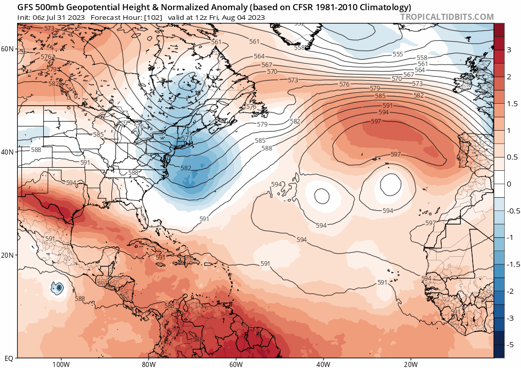
We’re is that trof? Long range Gfs illustrating would Could be a Pattern change just in time for cv season.
2 likes
-
Category5Kaiju

- Category 5
- Posts: 4313
- Joined: Thu Dec 24, 2020 12:45 pm
- Location: Seattle and Phoenix
Re: 2023 Indicators (SST, SAL, MSLP, Wind shear, Steering, Instability) and Day 16+ Models
I think there was a fellow Storm2k member who a few posts ago mentioned how there seems to be a tendency for the Atlantic basin to perform contrary to expectations. As in, high activity and high impacts happen when they are least expected to happen and that some of the more memorable storms and years (such as the entirety of 2017 or 2019's Hurricane Dorian) occurred when people least expected them to. Really interesting to think about for sure.
2 likes
Unless explicitly stated, all info in my posts is based on my own opinions and observations. Tropical storms and hurricanes can be extremely dangerous. Refer to an accredited weather research agency or meteorologist if you need to make serious decisions regarding an approaching storm.
-
SFLcane
- S2K Supporter
- Posts: 10281
- Age: 48
- Joined: Sat Jun 05, 2010 1:44 pm
- Location: Lake Worth Florida
Re: 2023 Indicators (SST, SAL, MSLP, Wind shear, Steering, Instability) and Day 16+ Models
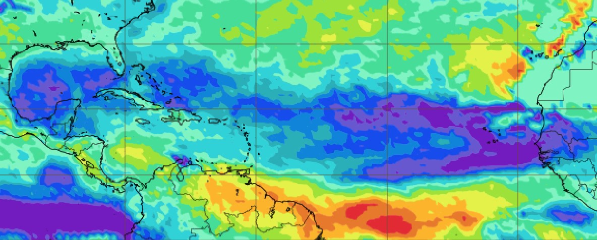
ECMWF Precipitation Probability distribution 8/14- 8/21
0 likes
-
wxman57

- Moderator-Pro Met

- Posts: 23118
- Age: 68
- Joined: Sat Jun 21, 2003 8:06 pm
- Location: Houston, TX (southwest)
Re: 2023 Indicators (SST, SAL, MSLP, Wind shear, Steering, Instability) and Day 16+ Models
August starts tomorrow and the deep tropics are dead. Gulf of Mexico is dominated by a death ridge, though there are some indications that the ridge will weaken in 10 days. Subtropics remain active, which is good. Let them all form in the subtropics and stay out to sea this season. Fine with me.
8 likes
Re: 2023 Indicators (SST, SAL, MSLP, Wind shear, Steering, Instability) and Day 16+ Models
wxman57 wrote:August starts tomorrow and the deep tropics are dead. Gulf of Mexico is dominated by a death ridge, though there are some indications that the ridge will weaken in 10 days. Subtropics remain active, which is good. Let them all form in the subtropics and stay out to sea this season. Fine with me.
The deep tropics are, indeed, pretty quiet, which as we know is quite common on July 31st. However, model consensus suggests that won't remain the case as we get into the 2nd half of August. In addition, the last 7 El Niño seasons (back to 2002) had a minimum of 3 NS with TCG in the MDR
Aug+. A very quiet Aug+ like in 1997 would mean little deep tropics activity, but you're forecasting a pretty active season and you didn't forecast that the activity would mainly originate in the subtropics as I recall.
Like you, I'd love the rest to all form in the subtropics and stay out to sea as I don't want any part of these monsters. But that wouldn't agree too well with your active forecast. Please correct me if I'm wrong about your forecast. Did you before or are you now forecasting mainly subtropical geneses from this point on?
2 likes
Personal Forecast Disclaimer:
The posts in this forum are NOT official forecasts and should not be used as such. They are just the opinion of the poster and may or may not be backed by sound meteorological data. They are NOT endorsed by any professional institution or storm2k.org. For official information, please refer to the NHC and NWS products.
The posts in this forum are NOT official forecasts and should not be used as such. They are just the opinion of the poster and may or may not be backed by sound meteorological data. They are NOT endorsed by any professional institution or storm2k.org. For official information, please refer to the NHC and NWS products.
Re: 2023 Indicators (SST, SAL, MSLP, Wind shear, Steering, Instability) and Day 16+ Models
I get it, seeing nothing on the ensembles or long range gfs at the start of August makes some people think it'll be a repeat of last year with nothing happening in August, but I really can't buy those odds two years in a row. (Although if 96/97L form we've already broken that, but I know most folks mean close in or MDR formation aka systems that impact land directly).
1 likes
-
Blown Away

- S2K Supporter
- Posts: 10253
- Joined: Wed May 26, 2004 6:17 am
Re: 2023 Indicators (SST, SAL, MSLP, Wind shear, Steering, Instability) and Day 16+ Models
BobHarlem wrote:I get it, seeing nothing on the ensembles or long range gfs at the start of August makes some people think it'll be a repeat of last year with nothing happening in August, but I really can't buy those odds two years in a row. (Although if 96/97L form we've already broken that, but I know most folks mean close in or MDR formation aka systems that impact land directly).
The lack of deep moisture IMO is the culprit, last year and this year so far. Sure there will be a few big hurricanes, but most systems are struggling w/ dry air.
0 likes
Hurricane Eye Experience: David 79, Irene 99, Frances 04, Jeanne 04, Wilma 05… Hurricane Brush Experience: Andrew 92, Erin 95, Floyd 99, Matthew 16, Irma 17, Ian 22, Nicole 22…
-
SFLcane
- S2K Supporter
- Posts: 10281
- Age: 48
- Joined: Sat Jun 05, 2010 1:44 pm
- Location: Lake Worth Florida
Re: 2023 Indicators (SST, SAL, MSLP, Wind shear, Steering, Instability) and Day 16+ Models
wxman57 wrote:August starts tomorrow and the deep tropics are dead. Gulf of Mexico is dominated by a death ridge, though there are some indications that the ridge will weaken in 10 days. Subtropics remain active, which is good. Let them all form in the subtropics and stay out to sea this season. Fine with me.
Not falling for this you seem to get all of S2K with this post about this time every year.
4 likes
Re: 2023 Indicators (SST, SAL, MSLP, Wind shear, Steering, Instability) and Day 16+ Models
For all years since 1995, avg # of Aug TCG for NS: 3.9 (1.5 during 8/1-15 and 2.4 during 8/16-31)
For 8 El Niño seasons, alone, since 1995: avg # of Aug TCG for NS: 3.1 (1.5 during 8/1-15 and 1.6 during 8/16-31)
For 8 El Niño seasons, alone, since 1995: avg # of Aug TCG for NS: 3.1 (1.5 during 8/1-15 and 1.6 during 8/16-31)
1 likes
Personal Forecast Disclaimer:
The posts in this forum are NOT official forecasts and should not be used as such. They are just the opinion of the poster and may or may not be backed by sound meteorological data. They are NOT endorsed by any professional institution or storm2k.org. For official information, please refer to the NHC and NWS products.
The posts in this forum are NOT official forecasts and should not be used as such. They are just the opinion of the poster and may or may not be backed by sound meteorological data. They are NOT endorsed by any professional institution or storm2k.org. For official information, please refer to the NHC and NWS products.
Re: 2023 Indicators (SST, SAL, MSLP, Wind shear, Steering, Instability) and Day 16+ Models
Assuming we're not about to have a 1997 or 2022 season of nothingness in Aug: IF there were to be no TCG Aug 1-15, that wouldn't at all mean to bet on a quiet 8/16-31.
During 1995-2022, seven seasons had no TCG 8/1-15. Those seven averaged 2.6 TCG 8/16-31 that became a NS. In comparison, the seasons with 1+ TCG during 8/1-15 had a similar 2.4 NS TCG 8/16-31. So, IF 8/1-15 of 2023 were to be very quiet, that would have little bearing on the expectation for 8/16-31 based strictly on these stats.
During 1995-2022, seven seasons had no TCG 8/1-15. Those seven averaged 2.6 TCG 8/16-31 that became a NS. In comparison, the seasons with 1+ TCG during 8/1-15 had a similar 2.4 NS TCG 8/16-31. So, IF 8/1-15 of 2023 were to be very quiet, that would have little bearing on the expectation for 8/16-31 based strictly on these stats.
4 likes
Personal Forecast Disclaimer:
The posts in this forum are NOT official forecasts and should not be used as such. They are just the opinion of the poster and may or may not be backed by sound meteorological data. They are NOT endorsed by any professional institution or storm2k.org. For official information, please refer to the NHC and NWS products.
The posts in this forum are NOT official forecasts and should not be used as such. They are just the opinion of the poster and may or may not be backed by sound meteorological data. They are NOT endorsed by any professional institution or storm2k.org. For official information, please refer to the NHC and NWS products.
-
CyclonicFury

- Category 5
- Posts: 2030
- Age: 27
- Joined: Sun Jul 02, 2017 12:32 pm
- Location: NC
- Contact:
Re: 2023 Indicators (SST, SAL, MSLP, Wind shear, Steering, Instability) and Day 16+ Models
It seems like every single year we have a modeled MDR system around this time of year that is expected to develop, gets assessed a high chance by NHC, then models drop it completely all at once and it fails to develop. After this happens, there's always the same discussion of how "it's always the next wave" and "maybe the MDR is just too hostile this year"
9 likes
NCSU B.S. in Meteorology Class of 2021. Tropical weather blogger at http://www.cyclonicfury.com. My forecasts and thoughts are NOT official, for official forecasts please consult the National Hurricane Center.
-
Category5Kaiju
- Category 5
- Posts: 4313
- Joined: Thu Dec 24, 2020 12:45 pm
- Location: Seattle and Phoenix
Re: 2023 Indicators (SST, SAL, MSLP, Wind shear, Steering, Instability) and Day 16+ Models
I honestly wouldn't be surprised if we see unenthusiastic models for the foreseeable future, and then all of a sudden one day they all become excited about activity and we find ourselves tracking storms in no time. Not sure if it's just me, but sometimes I feel that these models (particularly the GFS) are especially sensitive to dry air in late July/early August and don't really see far into the future well if there's a lot of dry air around at that moment.
2 likes
Unless explicitly stated, all info in my posts is based on my own opinions and observations. Tropical storms and hurricanes can be extremely dangerous. Refer to an accredited weather research agency or meteorologist if you need to make serious decisions regarding an approaching storm.
Re: 2023 Indicators (SST, SAL, MSLP, Wind shear, Steering, Instability) and Day 16+ Models
Category5Kaiju wrote:I honestly wouldn't be surprised if we see unenthusiastic models for the foreseeable future, and then all of a sudden one day they all become excited about activity and we find ourselves tracking storms in no time. Not sure if it's just me, but sometimes I feel that these models (particularly the GFS) are especially sensitive to dry air in late July/early August and don't really see far into the future well if there's a lot of dry air around at that moment.
After August 10th it wouldn’t surprise me if things start to pick up.
0 likes
Who is online
Users browsing this forum: No registered users and 20 guests