2023 Indicators (SST, SAL, MSLP, Wind shear, Steering, Instability) and Day 16+ Models

This is the general tropical discussion area. Anyone can take their shot at predicting a storms path.

Moderator: S2k Moderators

Forum rules

The posts in this forum are NOT official forecasts and should not be used as such. They are just the opinion of the poster and may or may not be backed by sound meteorological data. They are NOT endorsed by any professional institution or STORM2K. For official information, please refer to products from the National Hurricane Center and National Weather Service.

Help Support Storm2K
Message
Author
User avatar
SFLcane
S2K Supporter
S2K Supporter
Posts: 10163
Age: 47
Joined: Sat Jun 05, 2010 1:44 pm
Location: Lake Worth Florida

Re: 2023 Indicators (SST, SAL, MSLP, Wind shear, Steering, Instability) and Day 16+ Models

#1001 Postby SFLcane » Fri Jul 28, 2023 1:42 pm

LarryWx wrote:
gatorcane wrote:
SFLcane wrote:
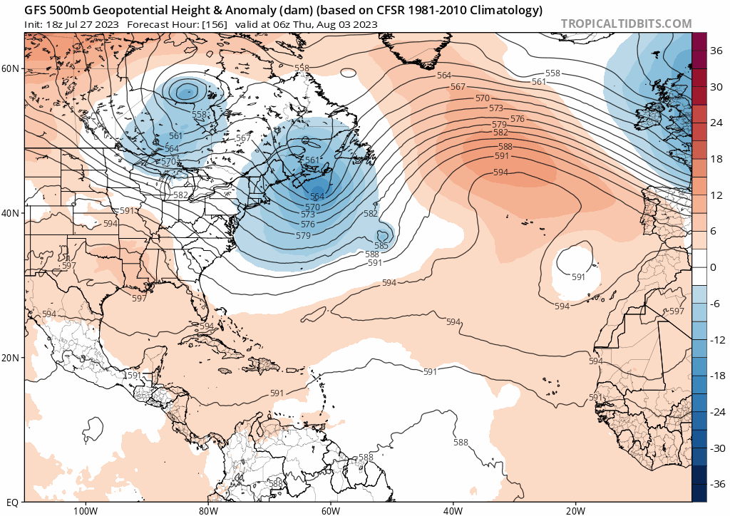
So should we cancel the season? That’s is an Impossible call to make in my opinion in late July. Things can change and unfortunately as stated by wxman57 there will be times when storms will not turn. Taking a peak at the long range gfs and cfs.

https://i.postimg.cc/Fz2sGR3r/IMG-7339.gif

https://i.postimg.cc/3wSym3SR/IMG-7340.png


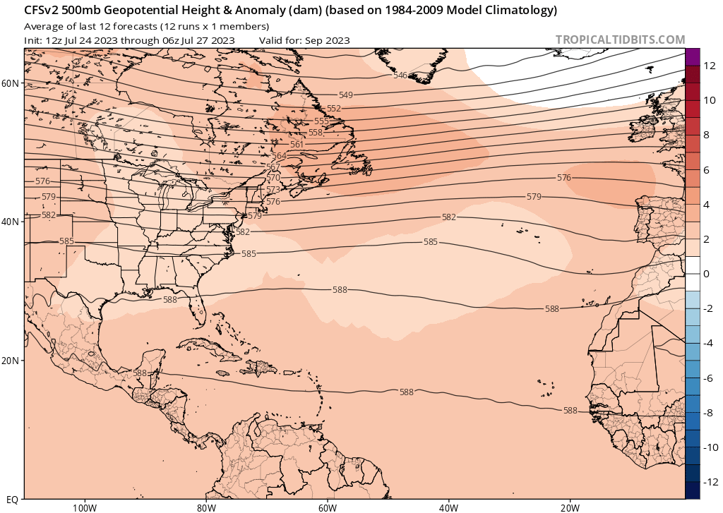
Long-range CFS model through Aug 29th shows mostly weak recurving systems some clipping the NE Caribbean, one gets close to the SE US at the end of the run. Overall pattern looks to be one of recurving storms, quiet Caribbean and Gulf:

https://www.pivotalweather.com/model.ph ... &dpdt=&mc=


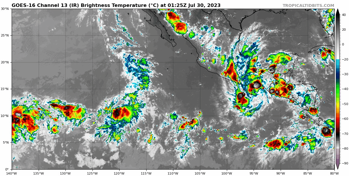
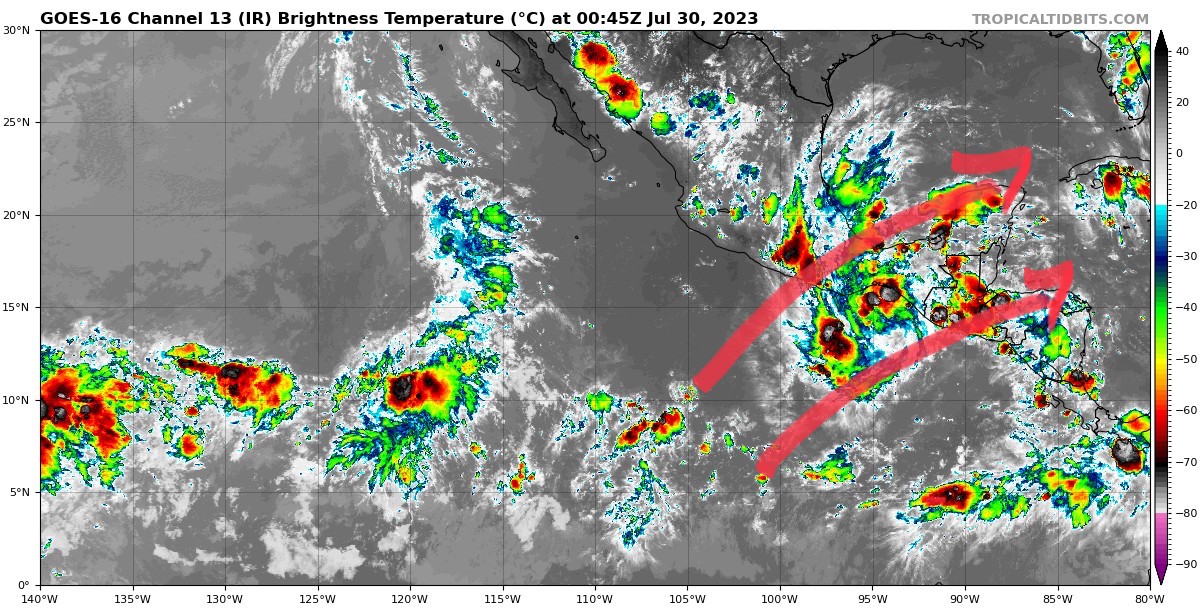
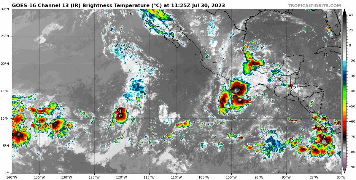
It does show them mainly recurving away from the CONUS or dissipating. However, we know that's what most MDR storms do even in August (say ~75%+) with an even higher % doing that during El Niño. But it does also suggest an active August MDR with four closed surface lows (excluding next week's potential). The lack of strong development may be a bias of the model for all I know.

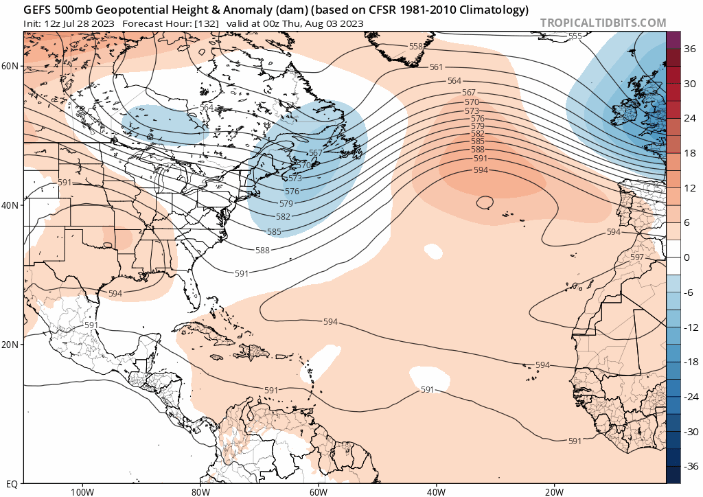
The one in late August near the SE coast along with the extended 7/27 GEFS that Adrian just posted remind me that late August is the start of the climo most active/dangerous period. So, even if there are three August MDR storms 8/7-8/20 that miss the Caribbean and stay way OTS from the CONUS, which is common anyway, it sometimes takes only one for a bad season. Thus the one shown at the end of the CFS in the Caribbean and then near the SE US would be enough to potentially make August, alone, a bad month if something akin to that were to actually occur. August wouldn't be remembered as a quiet month due to the first three if there's a bad one late. And that's not even considering what Sep and Oct might have in store!


Ridge builds just in time for capeverde season. :wink:

We shall see

Image
2 likes   

User avatar
Spacecoast
Category 2
Category 2
Posts: 758
Joined: Thu Aug 31, 2017 2:03 pm

Re: 2023 Indicators (SST, SAL, MSLP, Wind shear, Steering, Instability) and Day 16+ Models

#1002 Postby Spacecoast » Fri Jul 28, 2023 4:29 pm

7/28 Extended weekly :
TD's are anomalously higher % N of islands, Bahamas, and SFl..
Image
TStorm tracks:non-anomalous.
Image
2 likes   

User avatar
Hurricane2022
Category 5
Category 5
Posts: 1545
Joined: Tue Aug 23, 2022 11:38 pm
Location: Araçatuba, Brazil

Re: 2023 Indicators (SST, SAL, MSLP, Wind shear, Steering, Instability) and Day 16+ Models

#1003 Postby Hurricane2022 » Sat Jul 29, 2023 3:44 pm

1 likes   
Sorry for the bad English sometimes...!
For reliable and detailed information for any meteorological phenomenon, please consult the National Hurricane Center, Joint Typhoon Warning Center , or your local Meteo Center.

--------

Una cvm Christo, pro Christo, et in Christo. Sit nomen Domini benedictvm.

User avatar
Kingarabian
S2K Supporter
S2K Supporter
Posts: 15981
Joined: Sat Aug 08, 2009 3:06 am
Location: Honolulu, Hawaii

Re: 2023 Indicators (SST, SAL, MSLP, Wind shear, Steering, Instability) and Day 16+ Models

#1004 Postby Kingarabian » Sat Jul 29, 2023 6:11 pm

:uarrow: That is the control which is singular forecast. I would use the mean of the EPS to judge the concentration of sinking or rising motion over an area.
6 likes   
RIP Kobe Bryant

User avatar
SFLcane
S2K Supporter
S2K Supporter
Posts: 10163
Age: 47
Joined: Sat Jun 05, 2010 1:44 pm
Location: Lake Worth Florida

Re: 2023 Indicators (SST, SAL, MSLP, Wind shear, Steering, Instability) and Day 16+ Models

#1005 Postby SFLcane » Sat Jul 29, 2023 11:09 pm

Mark makes a good point we’re is the supposed windshear blowing from the epac into the Caribbean. 95L almost developed just ran into CA.

Image

I mean shear should be blowing the tops of 95L

Image
3 likes   

User avatar
crownweather
S2K Supporter
S2K Supporter
Posts: 595
Age: 50
Joined: Sat Aug 12, 2006 9:21 am
Location: Sturbridge, Massachusetts
Contact:

Re: 2023 Indicators (SST, SAL, MSLP, Wind shear, Steering, Instability) and Day 16+ Models

#1006 Postby crownweather » Sun Jul 30, 2023 5:51 am

Interesting statistic I found on the wettest Julys on record in Boston & what the rest of the hurricane season was like in terms of big hurricane landfalls.

 https://twitter.com/crownweather/status/1685597284229103616


0 likes   
Rob Lightbown
Crown Weather Services
https://crownweather.com

User avatar
SFLcane
S2K Supporter
S2K Supporter
Posts: 10163
Age: 47
Joined: Sat Jun 05, 2010 1:44 pm
Location: Lake Worth Florida

Re: 2023 Indicators (SST, SAL, MSLP, Wind shear, Steering, Instability) and Day 16+ Models

#1007 Postby SFLcane » Sun Jul 30, 2023 8:56 am

SFLcane wrote:Mark makes a good point we’re is the supposed windshear blowing from the epac into the Caribbean. 95L almost developed just ran into CA.

https://i.postimg.cc/5y4sq4sH/IMG-1316.gif

I mean shear should be blowing the tops of 95L

https://i.postimg.cc/Fsfytkkr/IMG-1317.jpg


Atlantic epac crossover during a strengthening El Niño? Ah yea no something is just a tad off.
1 likes   

User avatar
GCANE
S2K Supporter
S2K Supporter
Posts: 11497
Joined: Mon Oct 22, 2007 8:03 am

Re: 2023 Indicators (SST, SAL, MSLP, Wind shear, Steering, Instability) and Day 16+ Models

#1008 Postby GCANE » Sun Jul 30, 2023 8:56 am

Keeping an eye on the area north of Puerto Rico around 8/2 to 8/4.
Nothing on the models right now, but its a good setup if convection fires up.
High CAPE, low trades, ARWB
If pop ups fire over PR or Hispaniola and drift north, could spark something.
2 likes   

User avatar
SFLcane
S2K Supporter
S2K Supporter
Posts: 10163
Age: 47
Joined: Sat Jun 05, 2010 1:44 pm
Location: Lake Worth Florida

Re: 2023 Indicators (SST, SAL, MSLP, Wind shear, Steering, Instability) and Day 16+ Models

#1009 Postby SFLcane » Sun Jul 30, 2023 9:13 am

Those claiming we’re are the tc’s why is the Atlantic full of sinking dry air well it’s July 30th lol most of this in my opinion is just climo I would certainly wait another 25/30 days things can change pretty quick. We do this every year

Does this look to you like a sheared satellite were you typical have screaming shear going into the Caribbean tearing the tops of anything that tries to get going?

Image
2 likes   

User avatar
NDG
S2K Supporter
S2K Supporter
Posts: 15446
Joined: Sun Jul 09, 2006 10:14 pm
Location: Orlando, FL

Re: 2023 Indicators (SST, SAL, MSLP, Wind shear, Steering, Instability) and Day 16+ Models

#1010 Postby NDG » Sun Jul 30, 2023 10:34 am

I'm going to wait if the Atlantic responds to the CCKWs and MJO that are forecasted to come across the Basin during the month of August before saying that the high ACE forecasts are going to bust big time, shear during July across the Caribbean and Atlantic MDR has not been that bad compared to the recent EL Ninos.

Image
Image
Image
1 likes   

User avatar
cycloneye
Admin
Admin
Posts: 145351
Age: 68
Joined: Thu Oct 10, 2002 10:54 am
Location: San Juan, Puerto Rico

Re: 2023 Indicators (SST, SAL, MSLP, Wind shear, Steering, Instability) and Day 16+ Models

#1011 Postby cycloneye » Sun Jul 30, 2023 11:46 am

1 likes   
Visit the Caribbean-Central America Weather Thread where you can find at first post web cams,radars
and observations from Caribbean basin members Click Here

LarryWx
S2K Supporter
S2K Supporter
Posts: 6308
Joined: Sun Sep 07, 2003 2:04 pm
Location: GA

Re: 2023 Indicators (SST, SAL, MSLP, Wind shear, Steering, Instability) and Day 16+ Models

#1012 Postby LarryWx » Sun Jul 30, 2023 12:40 pm

SFLcane wrote: Does this look to you like a sheared satellite were you typical have screaming shear going into the Caribbean tearing the tops of anything that tries to get going?

https://i.postimg.cc/fTjmDpQ8/IMG-7355.gif


No, so far the "screaming shear" into the Caribbean common characteristic of moderate+ El Niños has not at all been dominant imho although that could always change later.
1 likes   
Personal Forecast Disclaimer:
The posts in this forum are NOT official forecasts and should not be used as such. They are just the opinion of the poster and may or may not be backed by sound meteorological data. They are NOT endorsed by any professional institution or storm2k.org. For official information, please refer to the NHC and NWS products.

LarryWx
S2K Supporter
S2K Supporter
Posts: 6308
Joined: Sun Sep 07, 2003 2:04 pm
Location: GA

Re: 2023 Indicators (SST, SAL, MSLP, Wind shear, Steering, Instability) and Day 16+ Models

#1013 Postby LarryWx » Sun Jul 30, 2023 1:02 pm

There's a very slight chance (~10%?) that 96L and 97L will both become TDs by tomorrow evening and also subsequently get named. If so, July 2023 would tie July 1997 at three for the most named storms with TCG in July in El Niño.
Last edited by LarryWx on Sun Jul 30, 2023 1:08 pm, edited 1 time in total.
1 likes   
Personal Forecast Disclaimer:
The posts in this forum are NOT official forecasts and should not be used as such. They are just the opinion of the poster and may or may not be backed by sound meteorological data. They are NOT endorsed by any professional institution or storm2k.org. For official information, please refer to the NHC and NWS products.

User avatar
Landy
Category 1
Category 1
Posts: 338
Joined: Wed Aug 11, 2021 7:43 pm
Location: Port Orange, FL

Re: 2023 Indicators (SST, SAL, MSLP, Wind shear, Steering, Instability) and Day 16+ Models

#1014 Postby Landy » Sun Jul 30, 2023 1:07 pm

LarryWx wrote:There's a very slight chance (~10%?) that 96L and 97L will both become TDs by tomorrow evening and also subsequently get named. If so, July 2023 would tie July 1997 at three for the most named storms with TCG in July at least in El Niño. I'll have to see if any other season had 4+. Anyone happen to know about non-El Nino record for NS with TCG in July?

2020 had 5 which seems pretty hard to beat.
2 likes   

User avatar
Category5Kaiju
Category 5
Category 5
Posts: 4097
Joined: Thu Dec 24, 2020 12:45 pm
Location: Seattle

Re: 2023 Indicators (SST, SAL, MSLP, Wind shear, Steering, Instability) and Day 16+ Models

#1015 Postby Category5Kaiju » Sun Jul 30, 2023 1:16 pm

The fact that we have a non-zero chance of seeing 2 more NSs form within the upcoming week for a total of 7 total nameable storms in the basin so far by early August....that's quite impressive, especially for a year that is expected to be at least a moderate El Nino later on. For a bit of context, at least since 1995:

- 2015 had 11 storms form throughout the entire season.
- 2014 had 8 storms form throughout the entire season.
- 2009 had 9 storms form throughout the entire season.
- 2006 had 10 storms form throughout the entire season.
- 2002 had 12 storms form throughout the entire season.
- 1997 had 8 storms form throughout the entire season.

Assuming there is no major period of silence going forward, we're on track to easily beat those years in total NS count.
1 likes   
Unless explicitly stated, all info in my posts is based on my own opinions and observations. Tropical storms and hurricanes can be extremely dangerous. Do not think you can beat Mother Nature. Refer to an accredited weather research agency or meteorologist if you need to make serious decisions regarding an approaching storm.

LarryWx
S2K Supporter
S2K Supporter
Posts: 6308
Joined: Sun Sep 07, 2003 2:04 pm
Location: GA

Re: 2023 Indicators (SST, SAL, MSLP, Wind shear, Steering, Instability) and Day 16+ Models

#1016 Postby LarryWx » Sun Jul 30, 2023 1:17 pm

Landy wrote:
LarryWx wrote:There's a very slight chance (~10%?) that 96L and 97L will both become TDs by tomorrow evening and also subsequently get named. If so, July 2023 would tie July 1997 at three for the most named storms with TCG in July at least in El Niño. I'll have to see if any other season had 4+. Anyone happen to know about non-El Nino record for NS with TCG in July?

2020 had 5 which seems pretty hard to beat.


Thank you. I also just saw that 2005 had five. But regarding just El Niño seasons, the record high number of July TCGs that became NSs for the last 50+ El Niño seasons is definitely three set in 1997.
1 likes   
Personal Forecast Disclaimer:
The posts in this forum are NOT official forecasts and should not be used as such. They are just the opinion of the poster and may or may not be backed by sound meteorological data. They are NOT endorsed by any professional institution or storm2k.org. For official information, please refer to the NHC and NWS products.

LarryWx
S2K Supporter
S2K Supporter
Posts: 6308
Joined: Sun Sep 07, 2003 2:04 pm
Location: GA

Re: 2023 Indicators (SST, SAL, MSLP, Wind shear, Steering, Instability) and Day 16+ Models

#1017 Postby LarryWx » Sun Jul 30, 2023 1:24 pm

Category5Kaiju wrote:The fact that we have a non-zero chance of seeing 2 more NSs form within the upcoming week for a total of 7 total nameable storms in the basin so far by early August....that's quite impressive, especially for a year that is expected to be at least a moderate El Nino later on. For a bit of context, at least since 1995:

- 2015 had 11 storms form throughout the entire season.
- 2014 had 8 storms form throughout the entire season.
- 2009 had 9 storms form throughout the entire season.
- 2006 had 10 storms form throughout the entire season.
- 2002 had 12 storms form throughout the entire season.
- 1997 had 8 storms form throughout the entire season.

Assuming there is no major period of silence going forward, we're on track to easily beat those years in total NS count.


And there's ample evidence that we've already been in a lower end moderate El Niño this month (~+1.1 Nino 3.4 SST anomaly averaged out this month per OISST) though they're normally officially declared retroactivity via ONI. But the July SOI has been pretty meager at -3 to -4.
2 likes   
Personal Forecast Disclaimer:
The posts in this forum are NOT official forecasts and should not be used as such. They are just the opinion of the poster and may or may not be backed by sound meteorological data. They are NOT endorsed by any professional institution or storm2k.org. For official information, please refer to the NHC and NWS products.

LarryWx
S2K Supporter
S2K Supporter
Posts: 6308
Joined: Sun Sep 07, 2003 2:04 pm
Location: GA

Re: 2023 Indicators (SST, SAL, MSLP, Wind shear, Steering, Instability) and Day 16+ Models

#1018 Postby LarryWx » Sun Jul 30, 2023 1:44 pm

LarryWx wrote:There's a very slight chance (~10%?) that 96L and 97L will both become TDs by tomorrow evening and also subsequently get named. If so, July 2023 would tie July 1997 at three for the most named storms with TCG in July in El Niño.


And arguably, the 12Z Euro at least gets close to step one, the two TDs by tomorrow evening.
0 likes   
Personal Forecast Disclaimer:
The posts in this forum are NOT official forecasts and should not be used as such. They are just the opinion of the poster and may or may not be backed by sound meteorological data. They are NOT endorsed by any professional institution or storm2k.org. For official information, please refer to the NHC and NWS products.

User avatar
ScottNAtlanta
Category 5
Category 5
Posts: 2367
Joined: Sat May 25, 2013 3:11 pm
Location: Atlanta, GA

Re: 2023 Indicators (SST, SAL, MSLP, Wind shear, Steering, Instability) and Day 16+ Models

#1019 Postby ScottNAtlanta » Sun Jul 30, 2023 2:02 pm

LarryWx wrote:
Category5Kaiju wrote:The fact that we have a non-zero chance of seeing 2 more NSs form within the upcoming week for a total of 7 total nameable storms in the basin so far by early August....that's quite impressive, especially for a year that is expected to be at least a moderate El Nino later on. For a bit of context, at least since 1995:

- 2015 had 11 storms form throughout the entire season.
- 2014 had 8 storms form throughout the entire season.
- 2009 had 9 storms form throughout the entire season.
- 2006 had 10 storms form throughout the entire season.
- 2002 had 12 storms form throughout the entire season.
- 1997 had 8 storms form throughout the entire season.

Assuming there is no major period of silence going forward, we're on track to easily beat those years in total NS count.


And there's ample evidence that we've already been in a lower end moderate El Niño this month (~+1.1 Nino 3.4 SST anomaly averaged out this month per OISST) though they're normally officially declared retroactivity via ONI. But the July SOI has been pretty meager at -3 to -4.

The SOI was on a real negative streak the last week, but it has come back to the positive range again
2 likes   
The posts in this forum are NOT official forecast and should not be used as such. They are just the opinion of the poster and may or may not be backed by sound meteorological data. They are NOT endorsed by any professional institution or storm2k.org. For official information, please refer to the NHC and NWS products.

lsuhurricane
Category 1
Category 1
Posts: 251
Joined: Tue Aug 15, 2017 2:53 pm

Re: 2023 Indicators (SST, SAL, MSLP, Wind shear, Steering, Instability) and Day 16+ Models

#1020 Postby lsuhurricane » Sun Jul 30, 2023 2:48 pm

12Z Euro Ensembles showing an eruption of development at the end of its run. Its that time....

Image
Last edited by lsuhurricane on Sun Jul 30, 2023 2:49 pm, edited 1 time in total.
0 likes   


Return to “Talkin' Tropics”

Who is online

Users browsing this forum: Cpv17 and 35 guests