-SOI is getting stronger, Daily SOI now in the -30s.
30-ay SOI is now in the negatives again, it literally took a nosedive!
Texas Summer 2023
Moderator: S2k Moderators
Forum rules

The posts in this forum are NOT official forecast and should not be used as such. They are just the opinion of the poster and may or may not be backed by sound meteorological data. They are NOT endorsed by any professional institution or STORM2K.
-
Iceresistance

- Category 5

- Posts: 9592
- Age: 22
- Joined: Sat Oct 10, 2020 9:45 am
- Location: Tecumseh, OK/Norman, OK
Re: Texas Summer 2023
4 likes
Bill 2015 & Beta 2020
Winter 2020-2021
All observations are in Tecumseh, OK unless otherwise noted.
Winter posts are focused mainly for Oklahoma & Texas.
Take any of my forecasts with a grain of salt, refer to the NWS, SPC, and NHC for official information
Never say Never with weather! Because ANYTHING is possible!
Winter 2020-2021
All observations are in Tecumseh, OK unless otherwise noted.
Winter posts are focused mainly for Oklahoma & Texas.
Take any of my forecasts with a grain of salt, refer to the NWS, SPC, and NHC for official information
Never say Never with weather! Because ANYTHING is possible!
Re: Texas Summer 2023
Ntxw wrote:869MB wrote:Edwards Limestone wrote:The runaway +AMO all but guarantees we will have droughts at least 50% of the time in Texas. We are at the PDOs mercy!
https://encrypted-tbn0.gstatic.com/images?q=tbn:ANd9GcT9511DuXlj9-7Fie4sr3eFcFq2rK7kPZihRoe9ZHbqP_gBEgV4JubWMhojmxQaF72NZgg&usqp=CAU
Am I crazy, or are we finally seeing some early signs that this persistent -PDO could be temporarily eroding now? Based upon the latest CDAS SST Anomaly 7-day Change map, we may finally be seeing some significant warming of the waters off of the US West Coast. We shall see if these trends persist through the rest of the Summer into the Fall...
https://www.tropicaltidbits.com/analysis/ocean/cdas-sflux_ssta7diff_global_1.png
You're not crazy it is happening. It has to because ENSO modulates the PDO. If longer term guidance is correct as others have mentioned and ridging pops further west would only speed up the PDO change.
Good deal, because it’s a change we badly need here in Texas because I’ve been waiting for these warmer anomalies to show up for months now. In fact, I should have also noted the cooler anomalies showing up further west of these warming SST’s which would be more representative of a +PDO orientation. I was somewhat hesitant to mention these initial changes because I didn’t want to jinx it.
Unfortunately, like I’ve mentioned before, we have been in this relatively cooler or negative phase of the PDO since around 2008 and probably got a minimum of several more years before we see a transition to a warmer or positive phase. Nevertheless, we will occasionally see these temporary warmer, ENSO modulated, spikes that may provide Texas with some breaks from the drier weather anomalies we usually see during these -PDO stretches.
1 likes
-
bubba hotep

- S2K Supporter

- Posts: 6014
- Joined: Wed Dec 28, 2016 1:00 am
- Location: Collin County Texas
Re: Texas Summer 2023
Iceresistance wrote:-SOI is getting stronger, Daily SOI now in the -30s.
30-ay SOI is now in the negatives again, it literally took a nosedive!

3 likes
Winter time post are almost exclusively focused on the DFW area.
-
Iceresistance
- Category 5
- Posts: 9592
- Age: 22
- Joined: Sat Oct 10, 2020 9:45 am
- Location: Tecumseh, OK/Norman, OK
Re: Texas Summer 2023
Pattern is similar to 2004, Modoki-like El Nino?
0 likes
Bill 2015 & Beta 2020
Winter 2020-2021
All observations are in Tecumseh, OK unless otherwise noted.
Winter posts are focused mainly for Oklahoma & Texas.
Take any of my forecasts with a grain of salt, refer to the NWS, SPC, and NHC for official information
Never say Never with weather! Because ANYTHING is possible!
Winter 2020-2021
All observations are in Tecumseh, OK unless otherwise noted.
Winter posts are focused mainly for Oklahoma & Texas.
Take any of my forecasts with a grain of salt, refer to the NWS, SPC, and NHC for official information
Never say Never with weather! Because ANYTHING is possible!
-
Texas Snowman

- Storm2k Moderator

- Posts: 6197
- Joined: Fri Jan 25, 2008 11:29 am
- Location: Denison, Texas
Re: Texas Summer 2023
By my count, today marked the 12th time we have been above 100 this summer here in the Denison/Sherman area. Definitely a lot better than some of the infamous summers I’ve lived through like the infamous 1980 (54 days above 100 during meteorological summer, 57 when counting three 100+ days in September).
Or the other infamous year, the summer of 2011. Found this Facebook memory for today referencing that difficult summer:
We went on to have 58 days above 100 during meteorological summer in 2011, 64 if you count the six days of 100+ in September.
Or the other infamous year, the summer of 2011. Found this Facebook memory for today referencing that difficult summer:
“As per KXII meterologist Steve LaNore on his weather blog: "Through July 25th, there have been 28 days of 100 temperatures at North Texas Regional Airport (2011). The average for a typical year is 15. The record is 56 days in 1956..not consecutive, but total for the year."
We went on to have 58 days above 100 during meteorological summer in 2011, 64 if you count the six days of 100+ in September.
1 likes
The above post and any post by Texas Snowman is NOT an official forecast and should not be used as such. It is just the opinion of the poster and may or may not be backed by sound meteorological data. It is NOT endorsed by any professional institution including storm2k.org. For official information, please refer to NWS products.
-
bubba hotep
- S2K Supporter
- Posts: 6014
- Joined: Wed Dec 28, 2016 1:00 am
- Location: Collin County Texas
Re: Texas Summer 2023
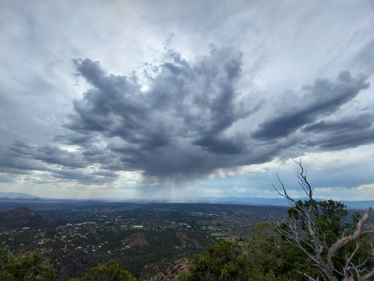
No snow on this trip, even the high country was hot and rainy. However, I did catch some storms on my run this afternoon.

3 likes
Winter time post are almost exclusively focused on the DFW area.

-
weatherdude1108
- Category 5
- Posts: 4228
- Joined: Tue Dec 13, 2011 1:04 pm
- Location: Northwest Austin/Cedar Park, TX
Re: Texas Summer 2023


000
FXUS64 KEWX 271922
AFDEWX
Area Forecast Discussion
National Weather Service Austin/San Antonio TX
222 PM CDT Thu Jul 27 2023
...New SHORT TERM, LONG TERM...
.SHORT TERM...
(Tonight through Friday night)
Issued at 222 PM CDT Thu Jul 27 2023
For this afternoon, elevated fire weather conditions are expected
across northern and western portions of the CWA as minRH`s fall to
around 15-20% and sustained winds increase into the 10-15 mph range.
Isolated areas across the Hill Country, southern Edwards Plateau,
and Rio Grande Plains may experience near-critical fire weather
conditions where the strongest winds (gusts in the 20-25 mph range
possible) and lowest RH overlap, especially considering the dry to
critically dry fuels across the region. Therefore, the decision was
made to go ahead and err on the side of caution by issuing a Fire
Danger Statement.
Tomorrow into Saturday, an inverted trough will work its way from
east to west along the southern periphery of the mid-upper ridge,
which will help keep temperatures relatively "cooler" through the
short term period. Unfortunately, this trough is just helping to
bring 500mb heights down to normal levels for this time of year, so
it won`t be bringing relief in the form of rain due to a lack of
lifting. However, the typical isolated seabreeze showers and storms
are still possible across far southeastern portions of the Coastal
Plains during the afternoon. At least elevated fire weather
conditions are expected again tomorrow afternoon with similar
conditions as today, so there may be a need to issue another Fire
Danger Statement in future forecast shifts.
&&
.LONG TERM...
(Saturday through Thursday)
Issued at 222 PM CDT Thu Jul 27 2023
Key message: Returning heat headlines are nearly guaranteed by
Sunday or Monday as upper ridging will recenter over the central to
southern high Plains and continues to dominate our weather in the
long term period. No rain, increasing temperatures, and slightly
higher humidity will characterize the forecast this weekend into
next week.
We`ll start out the long term period on Saturday with near to
slightly above normal temperatures, but height rises will quickly
follow and temperatures (both daytime highs and overnight lows) will
increase Sunday and again Monday. Could see the need for Heat
Advisories in a few areas on Sunday, and by Monday they`ll be a
guarantee for much of the region. Daytime highs Monday through
Thursday will be in the 98-106 degree range, and with slightly
higher afternoon humidity expected we`ll see many areas with heat
indices topping out near 108-112 along and east of I-35 once again
Tuesday through Thursday of next week.
Wish we had better news, but unfortunately we`ll continue to see
worsening drought impacts and a few more temperature records will be
threatened. By this time next week, we`ll likely be one day shy of
the all time record for consecutive 100 degree days at Austin Camp
Mabry (27, set in 2011). If Bergstrom (currently at 19 consecutive
days) can hit the century mark today through Saturday, it would then
be virtually guaranteed that site would break it`s record of 23
consecutive 100 degree days set in 1951 and tied in 1998.
0 likes
The preceding post is NOT an official forecast, and should not be used as such. It is only the opinion of the poster and may or may not be backed by sound meteorological data. It is NOT endorsed by any professional institution including storm2k.org. For Official Information please refer to the NHC and NWS products.

Re: Texas Summer 2023
Some good news, long range (take that for what it's worth) finally shows signs of the Aleutians ridge breaking down and replaced by a trough. We finally gut the lingering PDO/Nina like far North Pacific and try to couple with the El Nino.
Just got to get past this peak climo for heat averages...
Just got to get past this peak climo for heat averages...
4 likes
The above post and any post by Ntxw is NOT an official forecast and should not be used as such. It is just the opinion of the poster and may or may not be backed by sound meteorological data. It is NOT endorsed by any professional institution including Storm2k. For official information, please refer to NWS products.
Help support Storm2K!
-
South Texas Storms

- Professional-Met

- Posts: 4259
- Joined: Thu Jun 24, 2010 12:28 am
- Location: Houston, TX
Re: Texas Summer 2023
Ntxw wrote:Some good news, long range (take that for what it's worth) finally shows signs of the Aleutians ridge breaking down and replaced by a trough. We finally gut the lingering PDO/Nina like far North Pacific and try to couple with the El Nino.
Just got to get past this peak climo for heat averages...
Yeah the next few weeks still look rough for us unfortunately. I'm hopeful we'll finally see some changes in the pattern later in August and especially into September.
2 likes
-
cheezyWXguy

- Category 5
- Posts: 6282
- Joined: Mon Feb 13, 2006 12:29 am
- Location: Dallas, TX
Re: Texas Summer 2023
South Texas Storms wrote:Ntxw wrote:Some good news, long range (take that for what it's worth) finally shows signs of the Aleutians ridge breaking down and replaced by a trough. We finally gut the lingering PDO/Nina like far North Pacific and try to couple with the El Nino.
Just got to get past this peak climo for heat averages...
Yeah the next few weeks still look rough for us unfortunately. I'm hopeful we'll finally see some changes in the pattern later in August and especially into September.
Gfs has been going nuts with the ridge over the SWUS for several runs now, I don’t think I’ve ever seen a modeled 603dm contour the size of Arizona before… or ever
0 likes


-
Brent
- S2K Supporter
- Posts: 38755
- Age: 37
- Joined: Sun May 16, 2004 10:30 pm
- Location: Tulsa Oklahoma
- Contact:
Re: Texas Summer 2023
Well at least the days are getting noticeably shorter now..
1 likes
#neversummer

Re: Texas Summer 2023
Brent wrote:Well at least the days are getting noticeably shorter now..
Longer days > shorter days. Had this discussion before lol shorter days are for city folk who do nothing outside.
But hey if shorter days mean cooler weather then I’m all for it lol
0 likes
-
weatherdude1108
- Category 5
- Posts: 4228
- Joined: Tue Dec 13, 2011 1:04 pm
- Location: Northwest Austin/Cedar Park, TX
Re: Texas Summer 2023
The media nor the NWS is not mentioning this yet, they only go 7 days out, but I'm seeing signs in the future extended radar models of precipitation popping up in this area and no 100s, starting a week from this coming Monday. Model accuracy goes down the further out you go, so it could just be a mirage/radar fantasty land(?). Who knows?
Trying to keep vegetation (even native stuff) alive here is becoming more of a challenge, along with the poor wildlife (adding the recent years of hard freezes/ice storms), but we'll get through it, by golly! Gotta stay positive! The days are getting shorter! ☺️
Trying to keep vegetation (even native stuff) alive here is becoming more of a challenge, along with the poor wildlife (adding the recent years of hard freezes/ice storms), but we'll get through it, by golly! Gotta stay positive! The days are getting shorter! ☺️
4 likes
The preceding post is NOT an official forecast, and should not be used as such. It is only the opinion of the poster and may or may not be backed by sound meteorological data. It is NOT endorsed by any professional institution including storm2k.org. For Official Information please refer to the NHC and NWS products.
-
bubba hotep
- S2K Supporter
- Posts: 6014
- Joined: Wed Dec 28, 2016 1:00 am
- Location: Collin County Texas
Re: Texas Summer 2023
For North Texas, looks like another surge of heat next week, and then things should start to slowly improve. The ridge axis will shift westward, allowing for some NW flow and rain chances. Then after that climo will start working in our favor. I feel like we can almost start to see the light at the end of the tunnel... unless that light is a scorching September sun 
3 likes
Winter time post are almost exclusively focused on the DFW area.
-
TropicalTundra

- S2K Supporter
- Posts: 738
- Joined: Wed Oct 16, 2019 12:56 pm
- Location: Temple, Texas
Re: Texas Summer 2023
bubba hotep wrote:For North Texas, looks like another surge of heat next week, and then things should start to slowly improve. The ridge axis will shift westward, allowing for some NW flow and rain chances. Then after that climo will start working in our favor. I feel like we can almost start to see the light at the end of the tunnel... unless that light is a scorching September sun
Well as long as we get a lot of rain i'll "live".
Snowman better get to work on that fall thread
4 likes
Snow in Texas? What’s that?
Don't use my posts as forecast; I'm not a certified meteorologist! I just endorse cold weather, alright?
All observations I note are for Temple, Texas unless otherwise stated.
-
cheezyWXguy
- Category 5
- Posts: 6282
- Joined: Mon Feb 13, 2006 12:29 am
- Location: Dallas, TX
Re: Texas Summer 2023
bubba hotep wrote:For North Texas, looks like another surge of heat next week, and then things should start to slowly improve. The ridge axis will shift westward, allowing for some NW flow and rain chances. Then after that climo will start working in our favor. I feel like we can almost start to see the light at the end of the tunnel... unless that light is a scorching September sun
That trough around day 8-9 will be a much needed reprieve from the heat, and hopefully some good rain chances, but I’m not optimistic about it lasting long. Those cold sst anomalies off the west coast make me think the heat will stick around for a while afterward. Maybe not peak season heat, but persistent late summer heat. Really hoping for some good epac recurving hurricanes this fall, as that seems to be our best chance to put these heat waves to bed for the year imo
2 likes
-
bubba hotep
- S2K Supporter
- Posts: 6014
- Joined: Wed Dec 28, 2016 1:00 am
- Location: Collin County Texas
Re: Texas Summer 2023
It's fantasy land GFS but it's better than looking at bone dry scorcher fantasy land GFS

5 likes
Winter time post are almost exclusively focused on the DFW area.
Re: Texas Summer 2023
Wholesale NPAC change still in the cards, becoming more pronounced now to an El Nino Aleutian trough. Look for late summer trough in early August.
5 likes
The above post and any post by Ntxw is NOT an official forecast and should not be used as such. It is just the opinion of the poster and may or may not be backed by sound meteorological data. It is NOT endorsed by any professional institution including Storm2k. For official information, please refer to NWS products.
Help support Storm2K!
Help support Storm2K!
Return to “USA & Caribbean Weather”
Who is online
Users browsing this forum: Brent and 121 guests