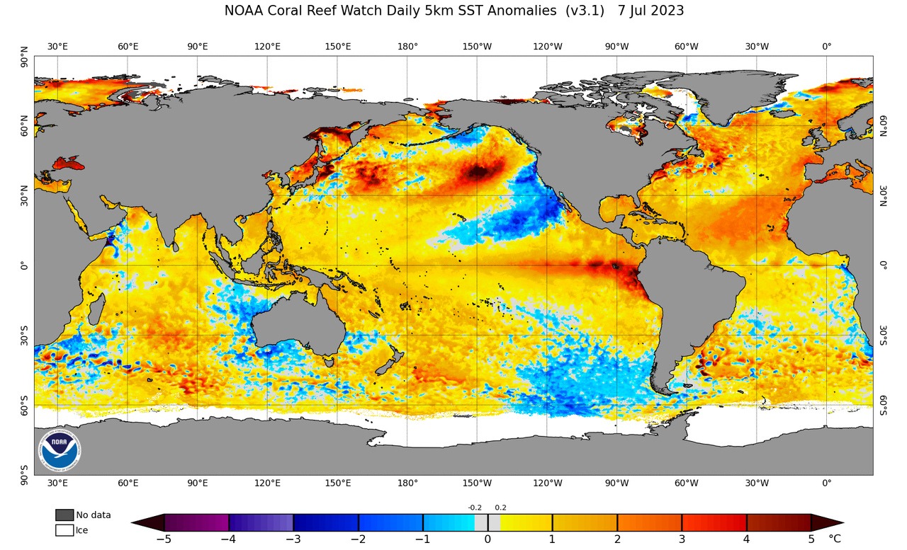
2023 Indicators (SST, SAL, MSLP, Wind shear, Steering, Instability) and Day 16+ Models

This is the general tropical discussion area. Anyone can take their shot at predicting a storms path.

Moderator: S2k Moderators

Forum rules

The posts in this forum are NOT official forecasts and should not be used as such. They are just the opinion of the poster and may or may not be backed by sound meteorological data. They are NOT endorsed by any professional institution or STORM2K. For official information, please refer to products from the National Hurricane Center and National Weather Service.

Help Support Storm2K
Message
Author
LarryWx
S2K Supporter
S2K Supporter
Posts: 6310
Joined: Sun Sep 07, 2003 2:04 pm
Location: GA

Re: 2023 Indicators (SST, SAL, MSLP, Wind shear, Steering, Instability) and Day 16+ Models

#761 Postby LarryWx » Sat Jul 08, 2023 7:42 am

Hurricane2022 wrote:
Iceresistance wrote:Almost the entire basin of the Atlantic is above average, what is going on?

Very likely due to Global Warming, since we are in a El Nino!


Indeed. Whichever way it is measured, whether it be the worldwide tropics, the N Hemisphere, or globally, there has been record or near record warmth for the last 60 days per the CFSR and the same for at least worldwide for ERA5. So, don't look for significant warm anomalies to go away anytime soon though a reduction is possible.

https://climate.copernicus.eu/copernicu ... d-globally

https://climatereanalyzer.org/clim/t2_daily/
1 likes   
Personal Forecast Disclaimer:
The posts in this forum are NOT official forecasts and should not be used as such. They are just the opinion of the poster and may or may not be backed by sound meteorological data. They are NOT endorsed by any professional institution or storm2k.org. For official information, please refer to the NHC and NWS products.

User avatar
Category5Kaiju
Category 5
Category 5
Posts: 4098
Joined: Thu Dec 24, 2020 12:45 pm
Location: Seattle

Re: 2023 Indicators (SST, SAL, MSLP, Wind shear, Steering, Instability) and Day 16+ Models

#762 Postby Category5Kaiju » Sat Jul 08, 2023 9:22 am

Interestingly, the sst anomaly profile we have now looks almost identical to the "very active" composite

 https://twitter.com/philklotzbach/status/1676970005081243649


1 likes   
Unless explicitly stated, all info in my posts is based on my own opinions and observations. Tropical storms and hurricanes can be extremely dangerous. Do not think you can beat Mother Nature. Refer to an accredited weather research agency or meteorologist if you need to make serious decisions regarding an approaching storm.

User avatar
gatorcane
S2K Supporter
S2K Supporter
Posts: 23691
Age: 47
Joined: Sun Mar 13, 2005 3:54 pm
Location: Boca Raton, FL

Re: 2023 Indicators (SST, SAL, MSLP, Wind shear, Steering, Instability) and Day 16+ Models

#763 Postby gatorcane » Sat Jul 08, 2023 8:10 pm

The waters across the Pacific south of Mexico near the equator continue to get warmer and are much above average now and spreading west. Hello El Niño, could be a strong one too.

Image
1 likes   

User avatar
Category5Kaiju
Category 5
Category 5
Posts: 4098
Joined: Thu Dec 24, 2020 12:45 pm
Location: Seattle

Re: 2023 Indicators (SST, SAL, MSLP, Wind shear, Steering, Instability) and Day 16+ Models

#764 Postby Category5Kaiju » Sat Jul 08, 2023 8:36 pm

gatorcane wrote:The waters across the Pacific south of Mexico near the equator continue to get warmer and are much above average now and spreading west. Hello El Niño, could be a strong one too.

https://i.postimg.cc/13hnjtbG/ssta-daily-current.png


That -PDO though stands out quite a bit. Quite fascinating to see how that is among the coldest regions of the global ocean currently, at least sst-anomaly-wise.
2 likes   
Unless explicitly stated, all info in my posts is based on my own opinions and observations. Tropical storms and hurricanes can be extremely dangerous. Do not think you can beat Mother Nature. Refer to an accredited weather research agency or meteorologist if you need to make serious decisions regarding an approaching storm.

User avatar
Spacecoast
Category 2
Category 2
Posts: 758
Joined: Thu Aug 31, 2017 2:03 pm

Re: 2023 Indicators (SST, SAL, MSLP, Wind shear, Steering, Instability) and Day 16+ Models

#765 Postby Spacecoast » Sun Jul 09, 2023 10:25 am

Decent SAL outbreak in process this week......
Image
3 likes   

LarryWx
S2K Supporter
S2K Supporter
Posts: 6310
Joined: Sun Sep 07, 2003 2:04 pm
Location: GA

Re: 2023 Indicators (SST, SAL, MSLP, Wind shear, Steering, Instability) and Day 16+ Models

#766 Postby LarryWx » Sun Jul 09, 2023 11:26 am

Spacecoast wrote:Decent SAL outbreak in process this week......
https://i.ibb.co/hgqLj81/ec3.jpg


Thanks for posting this. Is that typical SAL for mid July? I'm asking because July is during the heart of the strongest SAL on an average basis. SAL was near record weak in early June.
0 likes   
Personal Forecast Disclaimer:
The posts in this forum are NOT official forecasts and should not be used as such. They are just the opinion of the poster and may or may not be backed by sound meteorological data. They are NOT endorsed by any professional institution or storm2k.org. For official information, please refer to the NHC and NWS products.

User avatar
Spacecoast
Category 2
Category 2
Posts: 758
Joined: Thu Aug 31, 2017 2:03 pm

Re: 2023 Indicators (SST, SAL, MSLP, Wind shear, Steering, Instability) and Day 16+ Models

#767 Postby Spacecoast » Sun Jul 09, 2023 11:38 am

LarryWx wrote:
Spacecoast wrote:Decent SAL outbreak in process this week......
https://i.ibb.co/hgqLj81/ec3.jpg


Thanks for posting this. Is that typical SAL for mid July? I'm asking because July is during the heart of the strongest SAL on an average basis. SAL was near record weak in early June.

idk... I suspect this is not extra-ordinary for mid July.
Not being aware of any SAL anomaly charts, perhaps PWAT anomaly charts can be useful....
Image
Image
1 likes   

User avatar
Category5Kaiju
Category 5
Category 5
Posts: 4098
Joined: Thu Dec 24, 2020 12:45 pm
Location: Seattle

Re: 2023 Indicators (SST, SAL, MSLP, Wind shear, Steering, Instability) and Day 16+ Models

#768 Postby Category5Kaiju » Sun Jul 09, 2023 12:05 pm

Another thing I'd like to point out here is, I think the Atlantic hurricane season would experience more struggles if the PDO were to be + rather than -. Kind of like what happened in 2016, I'd argue that having a +PDO could really boost the EPAC while capping the Atlantic. Hence, if we were to have the same insanely warm MDR sst anomalies like we are seeing now but also have a +PDO with the El Nino, then that could still spell trouble for Atlantic activity, and I'd likely be more bearish with my outlook for the Atlantic.

But with the -PDO, at least as of recently, seemingly hurting EPAC activity, it kind of begs the question as to whether that should be more closely looked at aside from the Atlantic sst anomalies themselves in determining how active the Atlantic could possibly get this season.
2 likes   
Unless explicitly stated, all info in my posts is based on my own opinions and observations. Tropical storms and hurricanes can be extremely dangerous. Do not think you can beat Mother Nature. Refer to an accredited weather research agency or meteorologist if you need to make serious decisions regarding an approaching storm.

User avatar
Ntxw
Storm2k Moderator
Storm2k Moderator
Posts: 22786
Joined: Wed Oct 21, 2009 6:34 pm
Location: DFW, Texas

Re: 2023 Indicators (SST, SAL, MSLP, Wind shear, Steering, Instability) and Day 16+ Models

#769 Postby Ntxw » Sun Jul 09, 2023 12:16 pm

Category5Kaiju wrote:Another thing I'd like to point out here is, I think the Atlantic hurricane season would experience more struggles if the PDO were to be + rather than -. Kind of like what happened in 2016, I'd argue that having a +PDO could really boost the EPAC while capping the Atlantic. Hence, if we were to have the same insanely warm MDR sst anomalies like we are seeing now but also have a +PDO with the El Nino, then that could still spell trouble for Atlantic activity, and I'd likely be more bearish with my outlook for the Atlantic.

But with the -PDO, at least as of recently, seemingly hurting EPAC activity, it kind of begs the question as to whether that should be more closely looked at aside from the Atlantic sst anomalies themselves in determining how active the Atlantic could possibly get this season.


The PDO doesn't have a strong correlation with the Atlantic outside of the higher latitudes. If it did then last year would have gone gangbusters with very cold pdo and Nina. Aside with indirect relations from EPAC alongside PMM, ENSO itself is a higher energy budget for the globe overall due to its positioning in the deep tropics.

AMO is of more value on the Atlantic side for the basin.
2 likes   
The above post and any post by Ntxw is NOT an official forecast and should not be used as such. It is just the opinion of the poster and may or may not be backed by sound meteorological data. It is NOT endorsed by any professional institution including Storm2k. For official information, please refer to NWS products.

  Help support Storm2K!
Help Support Storm2K

User avatar
toad strangler
S2K Supporter
S2K Supporter
Posts: 4543
Joined: Sun Jul 28, 2013 3:09 pm
Location: Earth
Contact:

Re: 2023 Indicators (SST, SAL, MSLP, Wind shear, Steering, Instability) and Day 16+ Models

#770 Postby toad strangler » Sun Jul 09, 2023 2:51 pm

June 2023 Atlantic SST anomalies vs the Pat
 http://twitter.com/zlabe/status/1678101018473639937


0 likes   

User avatar
gatorcane
S2K Supporter
S2K Supporter
Posts: 23691
Age: 47
Joined: Sun Mar 13, 2005 3:54 pm
Location: Boca Raton, FL

Re: 2023 Indicators (SST, SAL, MSLP, Wind shear, Steering, Instability) and Day 16+ Models

#771 Postby gatorcane » Sun Jul 09, 2023 3:27 pm

toad strangler wrote:June 2023 Atlantic SST anomalies vs the Pat
http://twitter.com/zlabe/status/1678101018473639937?s=46&t=43ZHxVfHrYVe9pbpW8l0fg


Neat graphic. Most of the Atlantic anomalies are east so I could see an active MDR particularly east of the Lesser Antilles over the South-Central Atlantic out through the Cape Verde islands were those anomalously warm SSTs reside. But with the El Niño, it should keep the Gulf and Caribbean in check.
0 likes   

User avatar
toad strangler
S2K Supporter
S2K Supporter
Posts: 4543
Joined: Sun Jul 28, 2013 3:09 pm
Location: Earth
Contact:

Re: 2023 Indicators (SST, SAL, MSLP, Wind shear, Steering, Instability) and Day 16+ Models

#772 Postby toad strangler » Sun Jul 09, 2023 3:38 pm

gatorcane wrote:
toad strangler wrote:June 2023 Atlantic SST anomalies vs the Pat
http://twitter.com/zlabe/status/1678101018473639937?s=46&t=43ZHxVfHrYVe9pbpW8l0fg


Neat graphic. Most of the Atlantic anomalies are east so I could see an active MDR particularly east of the Lesser Antilles over the South-Central Atlantic out through the Cape Verde islands were those anomalously warm SSTs reside. But with the El Niño, it should keep the Gulf and Caribbean in check.


Yep, that’s what textbook climatology would infer. Except there isn’t any analogs to compare a Nino with off the charts Atlantic Basin SST warmth like this. Sometimes books get burned. Or rewritten with a new chapter added. We shall see.
1 likes   

User avatar
NDG
S2K Supporter
S2K Supporter
Posts: 15446
Joined: Sun Jul 09, 2006 10:14 pm
Location: Orlando, FL

Re: 2023 Indicators (SST, SAL, MSLP, Wind shear, Steering, Instability) and Day 16+ Models

#773 Postby NDG » Sun Jul 09, 2023 3:41 pm

gatorcane wrote:
toad strangler wrote:June 2023 Atlantic SST anomalies vs the Pat
http://twitter.com/zlabe/status/1678101018473639937?s=46&t=43ZHxVfHrYVe9pbpW8l0fg


Neat graphic. Most of the Atlantic anomalies are east so I could see an active MDR particularly east of the Lesser Antilles over the South-Central Atlantic out through the Cape Verde islands were those anomalously warm SSTs reside. But with the El Niño, it should keep the Gulf and Caribbean in check.


Which is what the Climate Models have shown all along, an active Tropical Atlantic MDR and in the SW Subtropical Atlantic, with dryer than average conditions for the Caribbean west of the Lesser Antilles.
IMO, the GOM could be a toss up, I wouldn't surprised if a few storms form there if the shear stays below average like it is right now.
2 likes   

User avatar
NDG
S2K Supporter
S2K Supporter
Posts: 15446
Joined: Sun Jul 09, 2006 10:14 pm
Location: Orlando, FL

Re: 2023 Indicators (SST, SAL, MSLP, Wind shear, Steering, Instability) and Day 16+ Models

#774 Postby NDG » Sun Jul 09, 2023 3:56 pm

Spacecoast wrote:Decent SAL outbreak in process this week......
https://i.ibb.co/hgqLj81/ec3.jpg


I find the Fox's Saharan dust graphics to be a bit exaggerating, according to this graphic and by looking at surface reports the current Saharan dust outbreaks are mostly average to below average in thickness.

Image
5 likes   

mantis83
Tropical Storm
Tropical Storm
Posts: 198
Joined: Fri Dec 05, 2003 4:47 pm

Re: 2023 Indicators (SST, SAL, MSLP, Wind shear, Steering, Instability) and Day 16+ Models

#775 Postby mantis83 » Sun Jul 09, 2023 4:24 pm

gatorcane wrote:
toad strangler wrote:June 2023 Atlantic SST anomalies vs the Pat
http://twitter.com/zlabe/status/1678101018473639937?s=46&t=43ZHxVfHrYVe9pbpW8l0fg


Neat graphic. Most of the Atlantic anomalies are east so I could see an active MDR particularly east of the Lesser Antilles over the South-Central Atlantic out through the Cape Verde islands were those anomalously warm SSTs reside. But with the El Niño, it should keep the Gulf and Caribbean in check.

good news for florida..... :lol:
0 likes   

User avatar
Hurricane2022
Category 5
Category 5
Posts: 1548
Joined: Tue Aug 23, 2022 11:38 pm
Location: Araçatuba, Brazil

Re: 2023 Indicators (SST, SAL, MSLP, Wind shear, Steering, Instability) and Day 16+ Models

#776 Postby Hurricane2022 » Sun Jul 09, 2023 5:02 pm

0 likes   
Sorry for the bad English sometimes...!
For reliable and detailed information for any meteorological phenomenon, please consult the National Hurricane Center, Joint Typhoon Warning Center , or your local Meteo Center.

--------

Una cvm Christo, pro Christo, et in Christo. Sit nomen Domini benedictvm.

User avatar
cycloneye
Admin
Admin
Posts: 145366
Age: 68
Joined: Thu Oct 10, 2002 10:54 am
Location: San Juan, Puerto Rico

Re: 2023 Indicators (SST, SAL, MSLP, Wind shear, Steering, Instability) and Day 16+ Models

#777 Postby cycloneye » Sun Jul 09, 2023 5:25 pm


Indeed, a great thread with different nuggets.
0 likes   
Visit the Caribbean-Central America Weather Thread where you can find at first post web cams,radars
and observations from Caribbean basin members Click Here

User avatar
Hurricane2022
Category 5
Category 5
Posts: 1548
Joined: Tue Aug 23, 2022 11:38 pm
Location: Araçatuba, Brazil

Re: 2023 Indicators (SST, SAL, MSLP, Wind shear, Steering, Instability) and Day 16+ Models

#778 Postby Hurricane2022 » Sun Jul 09, 2023 6:49 pm

1 likes   
Sorry for the bad English sometimes...!
For reliable and detailed information for any meteorological phenomenon, please consult the National Hurricane Center, Joint Typhoon Warning Center , or your local Meteo Center.

--------

Una cvm Christo, pro Christo, et in Christo. Sit nomen Domini benedictvm.

User avatar
Blown Away
S2K Supporter
S2K Supporter
Posts: 10147
Joined: Wed May 26, 2004 6:17 am

Re: 2023 Indicators (SST, SAL, MSLP, Wind shear, Steering, Instability) and Day 16+ Models

#779 Postby Blown Away » Sun Jul 09, 2023 7:11 pm

:uarrow:
Wow, that’s insane. Anything along the S FL Peninsula coast or GOM loop current would explode if upper conditions are good.
0 likes   
Hurricane Eye Experience: David 79, Irene 99, Frances 04, Jeanne 04, Wilma 05... EYE COMING MY WAY IN 2024…
Hurricane Brush Experience: Andrew 92, Erin 95, Floyd 99, Matthew 16, Irma 17, Ian 22, Nicole 22…

IsabelaWeather
Category 1
Category 1
Posts: 287
Age: 36
Joined: Tue Jul 07, 2020 7:29 am
Location: Isabela, Puerto Rico

Re: 2023 Indicators (SST, SAL, MSLP, Wind shear, Steering, Instability) and Day 16+ Models

#780 Postby IsabelaWeather » Sun Jul 09, 2023 8:20 pm

NDG wrote:
Spacecoast wrote:Decent SAL outbreak in process this week......
https://i.ibb.co/hgqLj81/ec3.jpg


I find the Fox's Saharan dust graphics to be a bit exaggerating, according to this graphic and by looking at surface reports the current Saharan dust outbreaks are mostly average to below average in thickness.

https://i.imgur.com/Y0Yotfa.gif


SAL gets talked about A LOT on this forum, but so far the outbreaks havent been very strong, the last one was decent; but more like a normal level. I like your graphic better than the exaggerated one.

2020 had insane SAL's and look how it ended up, I think SAL is talked about too much.
4 likes   


Return to “Talkin' Tropics”

Who is online

Users browsing this forum: jlauderdal, riapal, USTropics and 55 guests