2023 Indicators (SST, SAL, MSLP, Wind shear, Steering, Instability) and Day 16+ Models

This is the general tropical discussion area. Anyone can take their shot at predicting a storms path.

Moderator: S2k Moderators

Forum rules

The posts in this forum are NOT official forecasts and should not be used as such. They are just the opinion of the poster and may or may not be backed by sound meteorological data. They are NOT endorsed by any professional institution or STORM2K. For official information, please refer to products from the National Hurricane Center and National Weather Service.

Help Support Storm2K
Message
Author
User avatar
Category5Kaiju
Category 5
Category 5
Posts: 4097
Joined: Thu Dec 24, 2020 12:45 pm
Location: Seattle

Re: 2023 Indicators (SST, SAL, MSLP, Wind shear, Steering, Instability) and Day 16+ Models

#641 Postby Category5Kaiju » Thu Jun 22, 2023 9:33 pm

gatorcane wrote:
NDG wrote:
gatorcane wrote:Some aclimatological MDR activity could be a harbinger of an above normal or hyperactive Atlantic season, but a stout wall of shear looks to be sitting around Lesser Antilles and points wests which should be the demise of any system that tries to head west. That outcome would be supported by climatology but with an El Niño, and possibly a strong one, expected during the Atlantic peak months, what we are seeing now could also be a rinse and repeat come later, namely activity over the far eastern Atlantic and MDR only for systems to get sheared and struggle if they try to make a run west, unless they recurve and head north into the open Atlantic where better conditions would be present.


Compared to past El Ninos shear is currently much lower across the Caribbean & Atlantic MDR where it is usually fairly strong already in June as the El Nino cranks up. What is different this time is that where we usually find less wind shear during El Ninos is across the subtropical Atlantic, is the other way around this time so far. Time will tell but climate models continue to show much lower shear than you would expect during a moderate to strong El Nino during JAS period.

https://i.imgur.com/hdxMXj5.gif


The Atlantic may very well crank out a number of Cape Verde storms this year due to higher than normal SSTs there but the shear zone should reside during the climatological peaks months across the Caribbean due to the El Niño. The configuration tends to put Florida and the Gulf coast as well as the Caribbean islands less at risk with a higher risk to Bermuda and the east coast of the US particularly the mid-Atlantic north.

The other thing to note is the persistent, anomalously strong troughiness we have seen across the Eastern US with west to southwest windflow across the Gulf, Florida, and out into the Bahamas which we have seen for basically the past month. At times we were seeing west winds with gusts to 30mph across portions of the peninsula in June indicative of a complete lack of any kind of Bermuda High. This pattern is common during El Niños and could be an indicator that threats from the east for Florida and the SE US might be substantially reduced and with the shear zone across the Caribbean, threats from the south could be as well.


Your general analysis is correct, but of course we should all be mindful and careful that sometimes storms can "sneak through the cracks," like we saw with 1965's Betsy and 1929's Hurricane Two, both of which brought impacts to Southeastern Florida and the Bahamas in an El Nino year.
0 likes   
Unless explicitly stated, all info in my posts is based on my own opinions and observations. Tropical storms and hurricanes can be extremely dangerous. Do not think you can beat Mother Nature. Refer to an accredited weather research agency or meteorologist if you need to make serious decisions regarding an approaching storm.

User avatar
NDG
S2K Supporter
S2K Supporter
Posts: 15446
Joined: Sun Jul 09, 2006 10:14 pm
Location: Orlando, FL

Re: 2023 Indicators (SST, SAL, MSLP, Wind shear, Steering, Instability) and Day 16+ Models

#642 Postby NDG » Thu Jun 22, 2023 9:39 pm

gatorcane wrote:
NDG wrote:
gatorcane wrote:Some aclimatological MDR activity could be a harbinger of an above normal or hyperactive Atlantic season, but a stout wall of shear looks to be sitting around Lesser Antilles and points wests which should be the demise of any system that tries to head west. That outcome would be supported by climatology but with an El Niño, and possibly a strong one, expected during the Atlantic peak months, what we are seeing now could also be a rinse and repeat come later, namely activity over the far eastern Atlantic and MDR only for systems to get sheared and struggle if they try to make a run west, unless they recurve and head north into the open Atlantic where better conditions would be present.


Compared to past El Ninos shear is currently much lower across the Caribbean & Atlantic MDR where it is usually fairly strong already in June as the El Nino cranks up. What is different this time is that where we usually find less wind shear during El Ninos is across the subtropical Atlantic, is the other way around this time so far. Time will tell but climate models continue to show much lower shear than you would expect during a moderate to strong El Nino during JAS period.

https://i.imgur.com/hdxMXj5.gif


The Atlantic may very well crank out a number of Cape Verde storms this year due to higher than normal SSTs there but the shear zone should reside during the climatological peaks months across the Caribbean due to the El Niño. The configuration tends to put Florida and the Gulf coast as well as the Caribbean islands less at risk with a higher risk to Bermuda and the east coast of the US particularly the mid-Atlantic north.

The other thing to note is the persistent, anomalously strong troughiness we have seen across the Eastern US with west to southwest windflow across the Gulf, Florida, and out into the Bahamas which we have seen for basically the past month. At times we were seeing west winds with gusts to 30mph across portions of the peninsula in June indicative of a complete lack of any kind of Bermuda High. This pattern is common during El Niños and could be an indicator that threats from the east for Florida and the SE US might be substantially reduced and with the shear zone across the Caribbean, threats from the south could be as well.


There has never been the current scenario of a record +AMO and +ENSO in modern times. So far +AMO is winning the battle.
All I am saying is that so far Climate models have not backed down of a busy Atlantic season, where they track to is still up in the air but like you said if the constant eastern troughiness continues CV storms will most likely go out to sea, but if one sneaks out of the Caribbean the same troughiness can pull them out into the SE US.

Edit:
The same climate models don't show a tshear zone across the Caribbean during JAS as you would expect during a strong El Nino, time will tell.
Even in 2017 the first couple of storms that formed early in the MDR got decoupled as soon as they got to the Caribbean, as it is typical for this time of the year.
6 likes   

User avatar
SFLcane
S2K Supporter
S2K Supporter
Posts: 10163
Age: 47
Joined: Sat Jun 05, 2010 1:44 pm
Location: Lake Worth Florida

Re: 2023 Indicators (SST, SAL, MSLP, Wind shear, Steering, Instability) and Day 16+ Models

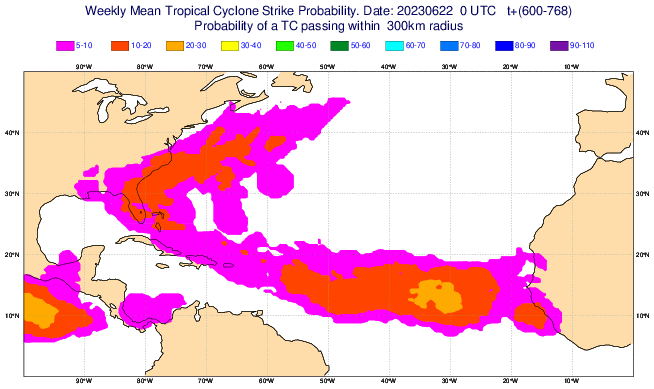
#643 Postby SFLcane » Fri Jun 23, 2023 10:37 am

7/16- 7/23 :double:


Image
1 likes   

User avatar
Cpv17
Category 5
Category 5
Posts: 4979
Joined: Wed Dec 07, 2016 2:24 pm
Location: Wharton/El Campo, TX

Re: 2023 Indicators (SST, SAL, MSLP, Wind shear, Steering, Instability) and Day 16+ Models

#644 Postby Cpv17 » Fri Jun 23, 2023 12:05 pm


Odd track for July. Looks more like October.
0 likes   

User avatar
HurricaneEnzo
Category 2
Category 2
Posts: 739
Joined: Wed Mar 14, 2018 12:18 pm
Location: Newport, NC (Hurricane Alley)

Re: 2023 Indicators (SST, SAL, MSLP, Wind shear, Steering, Instability) and Day 16+ Models

#645 Postby HurricaneEnzo » Fri Jun 23, 2023 12:18 pm

1996 Bertha-esque with timing and track.

1 likes   
Bertha 96' - Fran 96' - Bonnie 98' - Dennis 99' - Floyd 99' - Isabel 03' - Alex 04' - Ophelia 05' - Irene 11' - Arthur 14' - Matthew 16' - Florence 18' - Dorian 19' - Isaias 20' (countless other tropical storms and Hurricane swipes)

I am not a Professional Met just an enthusiast. Get your weather forecasts from the Pros!

User avatar
Teban54
Category 5
Category 5
Posts: 3206
Joined: Sat May 19, 2018 1:19 pm

Re: 2023 Indicators (SST, SAL, MSLP, Wind shear, Steering, Instability) and Day 16+ Models

#646 Postby Teban54 » Fri Jun 23, 2023 12:52 pm

HurricaneEnzo wrote:1996 Bertha-esque with timing and track.


Couldn't it also possibly be two different systems, one forming in the subtropics and one in MDR?
0 likes   

LarryWx
S2K Supporter
S2K Supporter
Posts: 6308
Joined: Sun Sep 07, 2003 2:04 pm
Location: GA

Re: 2023 Indicators (SST, SAL, MSLP, Wind shear, Steering, Instability) and Day 16+ Models

#647 Postby LarryWx » Fri Jun 23, 2023 12:58 pm


What is this from?
0 likes   
Personal Forecast Disclaimer:
The posts in this forum are NOT official forecasts and should not be used as such. They are just the opinion of the poster and may or may not be backed by sound meteorological data. They are NOT endorsed by any professional institution or storm2k.org. For official information, please refer to the NHC and NWS products.

User avatar
SFLcane
S2K Supporter
S2K Supporter
Posts: 10163
Age: 47
Joined: Sat Jun 05, 2010 1:44 pm
Location: Lake Worth Florida

Re: 2023 Indicators (SST, SAL, MSLP, Wind shear, Steering, Instability) and Day 16+ Models

#648 Postby SFLcane » Fri Jun 23, 2023 1:52 pm

LarryWx wrote:


What is this from?


Ecmwf site you can get weeklies ext..

https://t.co/kghQOg2qvd
1 likes   

User avatar
toad strangler
S2K Supporter
S2K Supporter
Posts: 4543
Joined: Sun Jul 28, 2013 3:09 pm
Location: Earth
Contact:

Re: 2023 Indicators (SST, SAL, MSLP, Wind shear, Steering, Instability) and Day 16+ Models

#649 Postby toad strangler » Sat Jun 24, 2023 8:44 am

Cpv17 wrote:


Odd track for July. Looks more like October.


That looks nothing like October. It looks similar to tracks climo would spit out mid August to mid September.
2 likes   

User avatar
cycloneye
Admin
Admin
Posts: 145351
Age: 68
Joined: Thu Oct 10, 2002 10:54 am
Location: San Juan, Puerto Rico

Re: 2023 Indicators (SST, SAL, MSLP, Wind shear, Steering, Instability) and Day 16+ Models

#650 Postby cycloneye » Sat Jun 24, 2023 8:48 am

0 likes   
Visit the Caribbean-Central America Weather Thread where you can find at first post web cams,radars
and observations from Caribbean basin members Click Here

User avatar
Cpv17
Category 5
Category 5
Posts: 4979
Joined: Wed Dec 07, 2016 2:24 pm
Location: Wharton/El Campo, TX

Re: 2023 Indicators (SST, SAL, MSLP, Wind shear, Steering, Instability) and Day 16+ Models

#651 Postby Cpv17 » Sat Jun 24, 2023 9:03 am

toad strangler wrote:
Cpv17 wrote:


Odd track for July. Looks more like October.


That looks nothing like October. It looks similar to tracks climo would spit out mid August to mid September.


It shows little to nothing in the Gulf which is what you’d get in October. With the exception being the far eastern Gulf.
0 likes   

User avatar
Cpv17
Category 5
Category 5
Posts: 4979
Joined: Wed Dec 07, 2016 2:24 pm
Location: Wharton/El Campo, TX

Re: 2023 Indicators (SST, SAL, MSLP, Wind shear, Steering, Instability) and Day 16+ Models

#652 Postby Cpv17 » Sat Jun 24, 2023 9:06 am


It has already started eroding. The SST’s in most of the MDR have now been cooling off little by little over the past 1-2 weeks.
0 likes   

WeatherBoy2000
Category 1
Category 1
Posts: 347
Joined: Mon Apr 10, 2023 9:29 am

Re: 2023 Indicators (SST, SAL, MSLP, Wind shear, Steering, Instability) and Day 16+ Models

#653 Postby WeatherBoy2000 » Sat Jun 24, 2023 9:16 am


This doesn't really surprise me, a burst of activity at the end of June into early July followed by weeks of unfavorable conditions has been a common occurrence for the past several years in the Atlantic. It looks like around the end of the month into early August, the pattern is predicted to flip back to resembling the one we're seeing now, except climatology should be more favorable as well. It's going to be interesting to watch how much the Atlantic cools along with if/how much the enso warms in the next month.
0 likes   

User avatar
Category5Kaiju
Category 5
Category 5
Posts: 4097
Joined: Thu Dec 24, 2020 12:45 pm
Location: Seattle

Re: 2023 Indicators (SST, SAL, MSLP, Wind shear, Steering, Instability) and Day 16+ Models

#654 Postby Category5Kaiju » Sat Jun 24, 2023 9:28 am

At this point in the year, I honestly think it might be a bit too late for the sst anomalies in the Atlantic to drop that considerably (even years like 2010 and 2017 saw their MDR sst anomalies decrease during the summer). Especially with what is predicted to be an active WAM, I simply cannot think of any major known mechanism that could single-handedly cool the Atlantic to average levels or what not.

I personally think that this is the bigger concern:
Image

With such an anomalously warm Canary Current, that warmth is expected to migrate southwest in the coming weeks and months, and that alone could serve as an important force to help keep the Atlantic anomalously warm.
3 likes   
Unless explicitly stated, all info in my posts is based on my own opinions and observations. Tropical storms and hurricanes can be extremely dangerous. Do not think you can beat Mother Nature. Refer to an accredited weather research agency or meteorologist if you need to make serious decisions regarding an approaching storm.

User avatar
toad strangler
S2K Supporter
S2K Supporter
Posts: 4543
Joined: Sun Jul 28, 2013 3:09 pm
Location: Earth
Contact:

Re: 2023 Indicators (SST, SAL, MSLP, Wind shear, Steering, Instability) and Day 16+ Models

#655 Postby toad strangler » Sat Jun 24, 2023 9:30 am

Cpv17 wrote:
toad strangler wrote:
Cpv17 wrote:
Odd track for July. Looks more like October.


That looks nothing like October. It looks similar to tracks climo would spit out mid August to mid September.


It shows little to nothing in the Gulf which is what you’d get in October. With the exception being the far eastern Gulf.


No, this is not correct. The Gulf historically is a prime spot in October. Maybe not the far western sections. But the rest of the gulf absolutely is. What SFL Cane’s post shows is a mid August to mid September look. For sure.

Image
Last edited by toad strangler on Sat Jun 24, 2023 9:40 am, edited 1 time in total.
3 likes   

ChrisH-UK
Category 2
Category 2
Posts: 625
Joined: Sat May 29, 2021 8:22 am

Re: 2023 Indicators (SST, SAL, MSLP, Wind shear, Steering, Instability) and Day 16+ Models

#656 Postby ChrisH-UK » Sat Jun 24, 2023 9:34 am

Category5Kaiju wrote:At this point in the year, I honestly think it might be a bit too late for the sst anomalies in the Atlantic to drop that considerably (even years like 2010 and 2017 saw their MDR sst anomalies decrease during the summer). Especially with what is predicted to be an active WAM, I simply cannot think of any major known mechanism that could single-handedly cool the Atlantic to average levels or what not.

I personally think that this is the bigger concern:
https://i.imgur.com/ZGcyB0n.png

With such an anomalously warm Canary Current, that warmth is expected to migrate southwest in the coming weeks and months, and that alone could serve as an important force to help keep the Atlantic anomalously warm.


Yep the warmer waters around the UK are making it much hotter than usual. The other thing is if storms recurve with the warmer waters I could see a true Tropical Storm actually reaching Europe area.
0 likes   

User avatar
Cpv17
Category 5
Category 5
Posts: 4979
Joined: Wed Dec 07, 2016 2:24 pm
Location: Wharton/El Campo, TX

Re: 2023 Indicators (SST, SAL, MSLP, Wind shear, Steering, Instability) and Day 16+ Models

#657 Postby Cpv17 » Sat Jun 24, 2023 9:44 am

toad strangler wrote:
Cpv17 wrote:
toad strangler wrote:
That looks nothing like October. It looks similar to tracks climo would spit out mid August to mid September.


It shows little to nothing in the Gulf which is what you’d get in October. With the exception being the far eastern Gulf.


No, this is not correct. The Gulf historically is a prime spot in October. Maybe not the far western sections. But the rest of the gulf absolutely is. What SFL Cane’s post shows is a mid August to mid September look. For sure.

https://i.ibb.co/vvxDbVz/35923-A31-51-B5-4-EE2-88-C5-261253-F7-E3-EC.png


When was the last time there was a cane in the central Gulf in October? Plus you mentioned it looked like tracks that would occur from mid August to mid September. Well yeah that could be true but from mid August to mid September, the whole Gulf is open. Not just the far eastern Gulf.
0 likes   

User avatar
toad strangler
S2K Supporter
S2K Supporter
Posts: 4543
Joined: Sun Jul 28, 2013 3:09 pm
Location: Earth
Contact:

Re: 2023 Indicators (SST, SAL, MSLP, Wind shear, Steering, Instability) and Day 16+ Models

#658 Postby toad strangler » Sat Jun 24, 2023 10:01 am

Cpv17 wrote:
toad strangler wrote:
Cpv17 wrote:
It shows little to nothing in the Gulf which is what you’d get in October. With the exception being the far eastern Gulf.


No, this is not correct. The Gulf historically is a prime spot in October. Maybe not the far western sections. But the rest of the gulf absolutely is. What SFL Cane’s post shows is a mid August to mid September look. For sure.

https://i.ibb.co/vvxDbVz/35923-A31-51-B5-4-EE2-88-C5-261253-F7-E3-EC.png


When was the last time there was a cane in the central Gulf in October? Plus you mentioned it looked like tracks that would occur from mid August to mid September. Well yeah that could be true but from mid August to mid September, the whole Gulf is open. Not just the far eastern Gulf.


2020. Not even three years ago yet. There were two. And they were both majors.
4 likes   

User avatar
SFLcane
S2K Supporter
S2K Supporter
Posts: 10163
Age: 47
Joined: Sat Jun 05, 2010 1:44 pm
Location: Lake Worth Florida

Re: 2023 Indicators (SST, SAL, MSLP, Wind shear, Steering, Instability) and Day 16+ Models

#659 Postby SFLcane » Sat Jun 24, 2023 10:28 am

2 likes   

User avatar
Cpv17
Category 5
Category 5
Posts: 4979
Joined: Wed Dec 07, 2016 2:24 pm
Location: Wharton/El Campo, TX

Re: 2023 Indicators (SST, SAL, MSLP, Wind shear, Steering, Instability) and Day 16+ Models

#660 Postby Cpv17 » Sat Jun 24, 2023 11:00 am


I’m not too concerned about late July through mid September being active and having favorable conditions. What I’m more interested in is what ridging will be like throughout that period.
3 likes   


Return to “Talkin' Tropics”

Who is online

Users browsing this forum: AnnularCane, Google [Bot], jconsor and 42 guests