Texas Summer 2023

U.S. & Caribbean Weather Discussions and Severe Weather Events

Moderator: S2k Moderators

Forum rules

The posts in this forum are NOT official forecast and should not be used as such. They are just the opinion of the poster and may or may not be backed by sound meteorological data. They are NOT endorsed by any professional institution or STORM2K.

Help Support Storm2K
Message
Author
HockeyTx82
S2K Supporter
S2K Supporter
Posts: 2540
Joined: Tue Oct 27, 2009 11:17 am
Location: Ponder, TX

Re: Texas Summer 2023

#241 Postby HockeyTx82 » Thu Jun 15, 2023 5:36 pm

bubba hotep wrote:Despite extreme CAPE and a SCP pushing 20, the only cell west of DFW has now died. Looks like the cells to the SW will miss DFW to the South, and the HRRR is consistently showing the storms in OK missing DFW to the NE. Looks like another non-event for DFW. Maybe we will get some rain on Saturday, lol


As soon as they went enhanced we should have known better.

Will those storms miss Denton city but maybe NE Denton County?
1 likes   
Don't hold me accountable for anything I post on this forum. Leave the real forecasting up to the professionals.

Location: Ponder, TX (all observation posts are this location unless otherwise noted)

WacoWx
Category 2
Category 2
Posts: 664
Joined: Mon Dec 28, 2009 4:14 pm
Location: NOT Waco, TX ----> Dallas, TX

Re: Texas Summer 2023

#242 Postby WacoWx » Thu Jun 15, 2023 5:53 pm

That supercell in southern OK is an absolute monster.
2 likes   

WacoWx
Category 2
Category 2
Posts: 664
Joined: Mon Dec 28, 2009 4:14 pm
Location: NOT Waco, TX ----> Dallas, TX

Re: Texas Summer 2023

#243 Postby WacoWx » Thu Jun 15, 2023 5:55 pm

There’s a donut shaped velocity return right in the middle of that huge mass.
0 likes   

User avatar
ElectricStorm
Category 5
Category 5
Posts: 5044
Age: 24
Joined: Tue Aug 13, 2019 11:23 pm
Location: Skiatook, OK / Norman, OK

Re: Texas Summer 2023

#244 Postby ElectricStorm » Thu Jun 15, 2023 5:56 pm

HockeyTx82 wrote:
bubba hotep wrote:Despite extreme CAPE and a SCP pushing 20, the only cell west of DFW has now died. Looks like the cells to the SW will miss DFW to the South, and the HRRR is consistently showing the storms in OK missing DFW to the NE. Looks like another non-event for DFW. Maybe we will get some rain on Saturday, lol


As soon as they went enhanced we should have known better.

Will those storms miss Denton city but maybe NE Denton County?

Looks like SPC thinks more storms will develop down there.

Mesoscale Discussion 1084
NWS Storm Prediction Center Norman OK
0533 PM CDT Thu Jun 15 2023

Areas affected...central and North Texas

Concerning...Tornado Watch 309...

Valid 152233Z - 160000Z

The severe weather threat for Tornado Watch 309 continues.

SUMMARY...Additional storm development/intensification is likely
through the remainder of the afternoon into this evening with
organizing supercells. Tornadoes, large to giant hail and damaging
winds remain possible.

DISCUSSION...Across portions of central and North TX, strong to
severe storms were observed maturing east of a dryline. Additional
development/intensification into the evening appears likely owing to
extreme buoyancy (5000 J/kg of MLCAPE) aided by an abnormally strong
EML and mid to upper 70s F dewpoints. 60 kt of effective shear
observed from area VADs will continue to support a predominately
supercell mode with the primary threat of large to giant hail. While
initially weak, especially with southern extent, low-level shear
should intensify this evening as the low-level jet increases. This
may also aid in some upscale growth of ongoing storms, and some
expansion of additional storms moving south across the Red River
from OK. Should this occur, a locally greater risk for damaging
winds may develop, especially across the northeastern portions of
WW309 toward the DFW metroplex later this evening.

..Lyons.. 06/15/2023
2 likes   
B.S Meteorology, University of Oklahoma '25

Please refer to the NHC, NWS, or SPC for official information.

User avatar
Texas Snowman
Storm2k Moderator
Storm2k Moderator
Posts: 6179
Joined: Fri Jan 25, 2008 11:29 am
Location: Denison, Texas

Re: Texas Summer 2023

#245 Postby Texas Snowman » Thu Jun 15, 2023 6:08 pm

2 likes   
The above post and any post by Texas Snowman is NOT an official forecast and should not be used as such. It is just the opinion of the poster and may or may not be backed by sound meteorological data. It is NOT endorsed by any professional institution including storm2k.org. For official information, please refer to NWS products.

User avatar
Texas Snowman
Storm2k Moderator
Storm2k Moderator
Posts: 6179
Joined: Fri Jan 25, 2008 11:29 am
Location: Denison, Texas

Re: Texas Summer 2023

#246 Postby Texas Snowman » Thu Jun 15, 2023 6:09 pm

0 likes   
The above post and any post by Texas Snowman is NOT an official forecast and should not be used as such. It is just the opinion of the poster and may or may not be backed by sound meteorological data. It is NOT endorsed by any professional institution including storm2k.org. For official information, please refer to NWS products.

User avatar
ElectricStorm
Category 5
Category 5
Posts: 5044
Age: 24
Joined: Tue Aug 13, 2019 11:23 pm
Location: Skiatook, OK / Norman, OK

Re: Texas Summer 2023

#247 Postby ElectricStorm » Thu Jun 15, 2023 6:20 pm

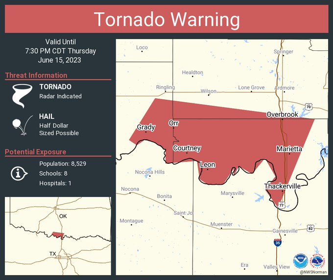
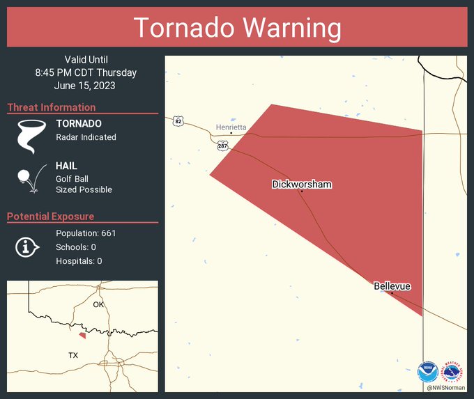
Big time meso just east of Loco, OK. Springer and Ardmore need to watch out
2 likes   
B.S Meteorology, University of Oklahoma '25

Please refer to the NHC, NWS, or SPC for official information.

User avatar
Texas Snowman
Storm2k Moderator
Storm2k Moderator
Posts: 6179
Joined: Fri Jan 25, 2008 11:29 am
Location: Denison, Texas

Re: Texas Summer 2023

#248 Postby Texas Snowman » Thu Jun 15, 2023 6:24 pm

0 likes   
The above post and any post by Texas Snowman is NOT an official forecast and should not be used as such. It is just the opinion of the poster and may or may not be backed by sound meteorological data. It is NOT endorsed by any professional institution including storm2k.org. For official information, please refer to NWS products.

User avatar
bubba hotep
S2K Supporter
S2K Supporter
Posts: 5837
Joined: Wed Dec 28, 2016 1:00 am
Location: Collin County Texas

Re: Texas Summer 2023

#249 Postby bubba hotep » Thu Jun 15, 2023 6:35 pm


That cell is already about 45 miles SW of where the 22z HRRR thinks it will be at 00z.
0 likes   
Winter time post are almost exclusively focused on the DFW area.

rwfromkansas
Category 5
Category 5
Posts: 2627
Joined: Sat Aug 27, 2005 12:47 am
Location: North Fort Worth

Re: Texas Summer 2023

#250 Postby rwfromkansas » Thu Jun 15, 2023 6:37 pm

A co-worker taught in Perryton the past few years and just moved back. That is awful.
0 likes   

User avatar
bubba hotep
S2K Supporter
S2K Supporter
Posts: 5837
Joined: Wed Dec 28, 2016 1:00 am
Location: Collin County Texas

Re: Texas Summer 2023

#251 Postby bubba hotep » Thu Jun 15, 2023 6:50 pm

Cell refuses to cross the River

Image
0 likes   
Winter time post are almost exclusively focused on the DFW area.

User avatar
bubba hotep
S2K Supporter
S2K Supporter
Posts: 5837
Joined: Wed Dec 28, 2016 1:00 am
Location: Collin County Texas

Re: Texas Summer 2023

#252 Postby bubba hotep » Thu Jun 15, 2023 7:12 pm

0 likes   
Winter time post are almost exclusively focused on the DFW area.

User avatar
bubba hotep
S2K Supporter
S2K Supporter
Posts: 5837
Joined: Wed Dec 28, 2016 1:00 am
Location: Collin County Texas

Re: Texas Summer 2023

#253 Postby bubba hotep » Thu Jun 15, 2023 7:40 pm

Lightning has really picked up with that cell, and it just blasted a new overshooting top. Might be about to produce. Also, that little trailing cell that has kind of been pulsing in intensity has really taken on an interesting look in the last bit.
0 likes   
Winter time post are almost exclusively focused on the DFW area.

User avatar
bubba hotep
S2K Supporter
S2K Supporter
Posts: 5837
Joined: Wed Dec 28, 2016 1:00 am
Location: Collin County Texas

Re: Texas Summer 2023

#254 Postby bubba hotep » Thu Jun 15, 2023 7:42 pm

0 likes   
Winter time post are almost exclusively focused on the DFW area.

User avatar
bubba hotep
S2K Supporter
S2K Supporter
Posts: 5837
Joined: Wed Dec 28, 2016 1:00 am
Location: Collin County Texas

Re: Texas Summer 2023

#255 Postby bubba hotep » Thu Jun 15, 2023 7:48 pm

That cell is tracking pretty close to eventually being a problem for the more densely populated portions of Collin County.
0 likes   
Winter time post are almost exclusively focused on the DFW area.

User avatar
bubba hotep
S2K Supporter
S2K Supporter
Posts: 5837
Joined: Wed Dec 28, 2016 1:00 am
Location: Collin County Texas

Re: Texas Summer 2023

#256 Postby bubba hotep » Thu Jun 15, 2023 8:12 pm

This is the smaller cell that has been trailing the monster cell.

Image
0 likes   
Winter time post are almost exclusively focused on the DFW area.

HockeyTx82
S2K Supporter
S2K Supporter
Posts: 2540
Joined: Tue Oct 27, 2009 11:17 am
Location: Ponder, TX

Re: Texas Summer 2023

#257 Postby HockeyTx82 » Thu Jun 15, 2023 8:20 pm

bubba hotep wrote:This is the smaller cell that has been trailing the monster cell.

https://pbs.twimg.com/media/FytLD5EaQAAyCGt?format=jpg&name=small


I'm not liking that track....
0 likes   
Don't hold me accountable for anything I post on this forum. Leave the real forecasting up to the professionals.

Location: Ponder, TX (all observation posts are this location unless otherwise noted)

User avatar
bubba hotep
S2K Supporter
S2K Supporter
Posts: 5837
Joined: Wed Dec 28, 2016 1:00 am
Location: Collin County Texas

Re: Texas Summer 2023

#258 Postby bubba hotep » Thu Jun 15, 2023 8:22 pm

HockeyTx82 wrote:
bubba hotep wrote:This is the smaller cell that has been trailing the monster cell.

https://pbs.twimg.com/media/FytLD5EaQAAyCGt?format=jpg&name=small


I'm not liking that track....


It's starting to make the turn and is really growing in size. I think DFW might have some issues later.
0 likes   
Winter time post are almost exclusively focused on the DFW area.

HockeyTx82
S2K Supporter
S2K Supporter
Posts: 2540
Joined: Tue Oct 27, 2009 11:17 am
Location: Ponder, TX

Re: Texas Summer 2023

#259 Postby HockeyTx82 » Thu Jun 15, 2023 8:27 pm

bubba hotep wrote:
HockeyTx82 wrote:
bubba hotep wrote:This is the smaller cell that has been trailing the monster cell.

https://pbs.twimg.com/media/FytLD5EaQAAyCGt?format=jpg&name=small


I'm not liking that track....


It's starting to make the turn and is really growing in size. I think DFW might have some issues later.


It looks to be going east but I might get spared here in Ponder, maybe.
1 likes   
Don't hold me accountable for anything I post on this forum. Leave the real forecasting up to the professionals.

Location: Ponder, TX (all observation posts are this location unless otherwise noted)

User avatar
ElectricStorm
Category 5
Category 5
Posts: 5044
Age: 24
Joined: Tue Aug 13, 2019 11:23 pm
Location: Skiatook, OK / Norman, OK

Re: Texas Summer 2023

#260 Postby ElectricStorm » Thu Jun 15, 2023 8:54 pm

Tor watch in OK has been replaced with a severe thunderstorm watch. Just a few miles outside of it here
0 likes   
B.S Meteorology, University of Oklahoma '25

Please refer to the NHC, NWS, or SPC for official information.


Return to “USA & Caribbean Weather”

Who is online

Users browsing this forum: wxman22 and 19 guests