Texas Summer 2023
Moderator: S2k Moderators
Forum rules

The posts in this forum are NOT official forecast and should not be used as such. They are just the opinion of the poster and may or may not be backed by sound meteorological data. They are NOT endorsed by any professional institution or STORM2K.
-
Iceresistance

- Category 5

- Posts: 9590
- Age: 22
- Joined: Sat Oct 10, 2020 9:45 am
- Location: Tecumseh, OK/Norman, OK
Re: Texas Summer 2023
5.5 inch Hail reported in Lela, TX last night
0 likes
Bill 2015 & Beta 2020
Winter 2020-2021
All observations are in Tecumseh, OK unless otherwise noted.
Winter posts are focused mainly for Oklahoma & Texas.
Take any of my forecasts with a grain of salt, refer to the NWS, SPC, and NHC for official information
Never say Never with weather! Because ANYTHING is possible!
Winter 2020-2021
All observations are in Tecumseh, OK unless otherwise noted.
Winter posts are focused mainly for Oklahoma & Texas.
Take any of my forecasts with a grain of salt, refer to the NWS, SPC, and NHC for official information
Never say Never with weather! Because ANYTHING is possible!


Re: Texas Summer 2023
bubba hotep wrote:WacoWx wrote:According the forecasts last week, we were supposed to be 3 days into the 100°+ stretch right now, so I am considering everyday below 100° now as a win. Lets hope it continues to remain stagnant.
The 00z Euro EPS backed off the heat for NTX some and is now only showing two days above 100F for DFW and, IMHO, it has a warm bias. It also shows rain chances returning as the ridge retrogrades towards the Baja. Would make sense with increasing signs of +ENSO. Unfortunately, it only helps us living up here on the northern periphery of the ridge, and Central and South Texas still get roasted.
By the way, what happened to the overnight storms that were in the forecast
It's definitely been a tricky forecast especially within the northern fringes. It's battle with a weakness along and N of I20 and ridge poking from Mexico. We've been influenced more on the weakness/trof side. Ridge may poke a little further north but not sprawling in any forecast I've seen. More typical of summer solstice heat run.
Nothing like summer of 2022.
1 likes
The above post and any post by Ntxw is NOT an official forecast and should not be used as such. It is just the opinion of the poster and may or may not be backed by sound meteorological data. It is NOT endorsed by any professional institution including Storm2k. For official information, please refer to NWS products.
Help support Storm2K!
-
Iceresistance
- Category 5
- Posts: 9590
- Age: 22
- Joined: Sat Oct 10, 2020 9:45 am
- Location: Tecumseh, OK/Norman, OK
Re: Texas Summer 2023
0z Runs on the Center of the Heat Dome track, Orange is ICON, Green is GFS, Red is Euro, and Blue is CMC.
Darker colors (Except the ICON) are the Ensembles, and the lighter colors are the OP runs.

https://s12.gifyu.com/images/SQbq2.png
Darker colors (Except the ICON) are the Ensembles, and the lighter colors are the OP runs.
https://s12.gifyu.com/images/SQbq2.png
1 likes
Bill 2015 & Beta 2020
Winter 2020-2021
All observations are in Tecumseh, OK unless otherwise noted.
Winter posts are focused mainly for Oklahoma & Texas.
Take any of my forecasts with a grain of salt, refer to the NWS, SPC, and NHC for official information
Never say Never with weather! Because ANYTHING is possible!
Winter 2020-2021
All observations are in Tecumseh, OK unless otherwise noted.
Winter posts are focused mainly for Oklahoma & Texas.
Take any of my forecasts with a grain of salt, refer to the NWS, SPC, and NHC for official information
Never say Never with weather! Because ANYTHING is possible!
-
bubba hotep

- S2K Supporter

- Posts: 6014
- Joined: Wed Dec 28, 2016 1:00 am
- Location: Collin County Texas

-
rwfromkansas
- Category 5
- Posts: 3038
- Joined: Sat Aug 27, 2005 12:47 am
- Location: North Fort Worth
-
HockeyTx82
- S2K Supporter
- Posts: 2795
- Joined: Tue Oct 27, 2009 11:17 am
- Location: Ponder, TX
Re: Texas Summer 2023
Aside from it being muggy looks like a Fall day here in Ponder and Denton as I drive around...... 
0 likes
Don't hold me accountable for anything I post on this forum. Leave the real forecasting up to the professionals.
Location: Ponder, TX (all observation posts are this location unless otherwise noted)
Location: Ponder, TX (all observation posts are this location unless otherwise noted)

Re: Texas Summer 2023
Lather, rinse, repeat. Greatest chance of storms in Texas is NE of Dallas towards the Ark-la-tex. More conditional threat in the other risk areas. My location seems to continue being split by the severe weather, with storms north of me heading east or northeast, with storms to the west continually diving southeast. Anything headed towards Longview tends to die out by the time it gets here. Nothing wrong with that... but interesting to watch it play out over the last few days.
0 likes
-
Iceresistance
- Category 5
- Posts: 9590
- Age: 22
- Joined: Sat Oct 10, 2020 9:45 am
- Location: Tecumseh, OK/Norman, OK
Re: Texas Summer 2023

0 likes
Bill 2015 & Beta 2020
Winter 2020-2021
All observations are in Tecumseh, OK unless otherwise noted.
Winter posts are focused mainly for Oklahoma & Texas.
Take any of my forecasts with a grain of salt, refer to the NWS, SPC, and NHC for official information
Never say Never with weather! Because ANYTHING is possible!
Winter 2020-2021
All observations are in Tecumseh, OK unless otherwise noted.
Winter posts are focused mainly for Oklahoma & Texas.
Take any of my forecasts with a grain of salt, refer to the NWS, SPC, and NHC for official information
Never say Never with weather! Because ANYTHING is possible!
-
bubba hotep
- S2K Supporter
- Posts: 6014
- Joined: Wed Dec 28, 2016 1:00 am
- Location: Collin County Texas
Re: Texas Summer 2023
Nasty supercell up along the Red River this morning.
0 likes
Winter time post are almost exclusively focused on the DFW area.
-
bubba hotep
- S2K Supporter
- Posts: 6014
- Joined: Wed Dec 28, 2016 1:00 am
- Location: Collin County Texas
Re: Texas Summer 2023
Pretty big expansion of the Day 2 Slight down into Texas

0 likes
Winter time post are almost exclusively focused on the DFW area.

Re: Texas Summer 2023
bubba hotep wrote:Pretty big expansion of the Day 2 Slight down into Texas
https://www.spc.noaa.gov/public/state/images/TX_swody2.png
I thought by now y’all were supposed to be in the frying pan like us?
1 likes
Re: Texas Summer 2023
Radar confirmed tornado about 7 miles north of Atlanta, TX about an hour ago. Also looks like really strong straight line winds went through that area.
1 likes
-
Brent
- S2K Supporter
- Posts: 38755
- Age: 37
- Joined: Sun May 16, 2004 10:30 pm
- Location: Tulsa Oklahoma
- Contact:
Re: Texas Summer 2023
Cpv17 wrote:bubba hotep wrote:Pretty big expansion of the Day 2 Slight down into Texas
https://www.spc.noaa.gov/public/state/images/TX_swody2.png
I thought by now y’all were supposed to be in the frying pan like us?
Totally backed off up here. We've already hit 94 last week and nothing above that forecast anymore
I can remember last June having nights not get below 85
1 likes
#neversummer
-
Rgv20

- S2K Supporter
- Posts: 2466
- Age: 39
- Joined: Wed Jan 05, 2011 5:42 pm
- Location: Edinburg/McAllen Tx
Re: Texas Summer 2023
I'm used to the Heat but damn the humidity has been unreal this past few days. My personal weather station is currently showing 102 with a dew point of 79 for a 123 heat index... 
FXUS64 KBRO 141955
AFDBRO
Area Forecast Discussion
National Weather Service Brownsville TX
255 PM CDT Wed Jun 14 2023
...New SHORT TERM, LONG TERM, MARINE...
.SHORT TERM...
(Tonight through Thursday night)
Issued at 236 PM CDT Wed Jun 14 2023
Short Term Highlights:
- Life-threatening heat continues
- Breezy to windy south-southeasterly winds (even overnight)
- Haze (especially near the coast)
- Dangerous currents at the beach
The main concern for the short term period continues to be the
life- threatening heat that`s expected to continue for the
foreseeable future, thanks to the mid level ridge that`s building
over Deep South Texas and elevated surface dew points. Heat
indices exceeded 100F by 9 AM this morning, and have begun to
verify our Heat Advisory by early this afternoon with 111F+ across
a good portion of Deep South Texas. While some wispy cirrus
clouds will periodically help to block out a little bit of the
solar radiation, they will likely only put a slight dent in the
temperatures...but dew points are looking slightly drier than
yesterday as the heat helps to dry some of soil moisture...so the
combination of these two factors will help to keep heat indices
slightly lower than yesterday. With that in mind and the current
trend in temperatures and dew points for today, the Heat Advisory
in effect until 8 PM should be sufficient...but dew points seem to
be bouncing around this afternoon, with McAllen jumping between
108F and 120F in the last hour or two...so we`ll continue to
monitor for the potential need to upgrade to an Excessive Heat
Warning for a few hours this afternoon.
Tonight, winds will remain elevated and heat indices are likely
to only drop to around 90F like we saw last night...not much of a
break from the heat. And haze could return...
Satellite imagery and Total Aerosol Optical Thickness (AOT)
models show smoke from fires in Mexico continuing to stream into
Deep South Texas through the short term. This uptick in AOT and
high relative humidity values (especially overnight into the
morning hours) will likely keep the haze around through the short
term period. The haze will likely be densest along the coast where
cooler water temperatures from upwelling will help to keep the
relative humidity elevated. This also means that the air quality
will be reduced as well.
Thursday`s ambient temperatures will exceed today`s as the ridge
continues to build overhead. However, with lower confidence in the
dew points, tomorrow`s heat indices are a bit a tricky. Decided
to keep the Excessive Heat Watch in effect and issued a Heat
Advisory for the remaining counties (except for the barrier
island). Upgrades to Excessive Warnings may be needed.
Finally, in addition to the haze and the heat, beachgoers may be
impacted by dangerous currents in the surf zone at the beach. Wave
heights have increased due to the persistent moderate to fresh
south to southeasterly winds, increasing the risk of rip currents
and strengthening the south-to-north longshore current. If
venturing into the water to escape the heat, be sure to swim at
beaches with lifeguards on duty and know what to do if you get
caught in a rip current. If in doubt about the conditions, ask a
lifeguard.
&&
.LONG TERM...
(Friday through next Wednesday)
Issued at 236 PM CDT Wed Jun 14 2023
Hot, dry weather will continue. A 500mb ridge over northern
Mexico will build over deep South Texas by the weekend and will
remain anchored over the region into next week. At the surface,
broad high pressure will continue across the Gulf of Mexico,
supporting at least an onshore breeze. As the mid-level ridge
builds and the overnight heat continues, daytime temperatures will
increase to near record values through the remainder of the long
term period.
Mid to upper 90s will be common along the coast, with the mercury
quickly reaching the century mark just inland and soaring to
sizzling 105 to 110 values as soon as the US 281/I-69C corridor.
Afternoon high temperature readings of 110 to 115 degrees will be
possible for the Upper Valley to RGV Plains. Overnight low
temperatures will only decrease to the 70s near the coast to
around 80 degrees along the Rio Grande each night. The combination
of very hot weather and elevated dewpoints will support heat
index values in the heat advisory range of 111-115 degrees with
locally higher values every afternoon, driving heat advisory
conditions through the period, and even potential excessive heat
warnings.
Fire weather may become more of an issue over the weekend or into
early next week, with RH values along and west of US 281 dropping
below 30 percent and potentially into the teens across Zapata
County, with 20 foot winds becoming breezy each afternoon. Most
areas will probably not reach fire weather criteria, but current
guidance leans towards Fire Danger Statements potentially Saturday
through Monday.
1 likes
The following post is NOT an official forecast and should not be used as such. It is just the opinion of the poster and may or may not be backed by sound meteorological data. It is NOT endorsed by any professional institution including storm2k.org For Official Information please refer to the NHC and NWS products.
Re: Texas Summer 2023
https://www.spc.noaa.gov/products/md/md1046.html
Afternoon/evening severe threat increasing for NC/NE Texas. A watch is likely coming (80%). Giant hail and severe wind are the main threats.
Afternoon/evening severe threat increasing for NC/NE Texas. A watch is likely coming (80%). Giant hail and severe wind are the main threats.
1 likes
-
rwfromkansas
- Category 5
- Posts: 3038
- Joined: Sat Aug 27, 2005 12:47 am
- Location: North Fort Worth
Re: Texas Summer 2023
Is Pivotal Weather crawling for others? It's loading images like I have 56k on my laptop. And I have Gigabit internet. TT is loading fast.
0 likes
-
bubba hotep
- S2K Supporter
- Posts: 6014
- Joined: Wed Dec 28, 2016 1:00 am
- Location: Collin County Texas
Re: Texas Summer 2023
Here we go again, 3rd watch in 24 hrs lol
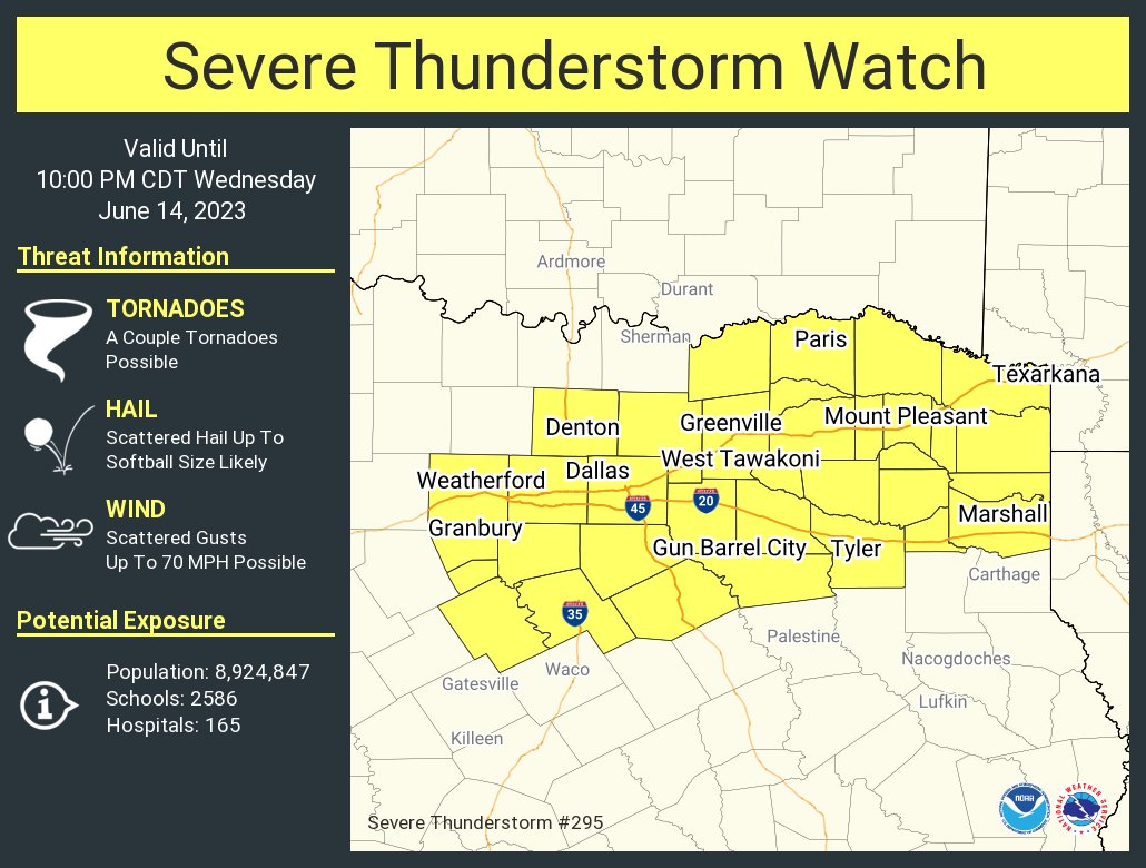
4 likes
Winter time post are almost exclusively focused on the DFW area.
-
South Texas Storms

- Professional-Met

- Posts: 4259
- Joined: Thu Jun 24, 2010 12:28 am
- Location: Houston, TX
Re: Texas Summer 2023
Cpv17 wrote:bubba hotep wrote:Pretty big expansion of the Day 2 Slight down into Texas
https://www.spc.noaa.gov/public/state/images/TX_swody2.png
I thought by now y’all were supposed to be in the frying pan like us?
Today is the last relatively cool day for north TX. 90s return tomorrow with near 100 likely this weekend through much of next week.
1 likes
-
bubba hotep
- S2K Supporter
- Posts: 6014
- Joined: Wed Dec 28, 2016 1:00 am
- Location: Collin County Texas
Re: Texas Summer 2023
cstrunk wrote:https://www.spc.noaa.gov/products/md/md1046.html
Afternoon/evening severe threat increasing for NC/NE Texas. A watch is likely coming (80%). Giant hail and severe wind are the main threats.
Extreme buoyancy and strong vertical shear will likely support splitting
supercells with a risk for large to giant hail and damaging winds.
1 likes
Winter time post are almost exclusively focused on the DFW area.


Re: Texas Summer 2023
Biggy hail up to 4 inches :-O that would hurt. Persistent giant hail threat this week.
1 likes
Return to “USA & Caribbean Weather”
Who is online
Users browsing this forum: No registered users and 136 guests