This is the general tropical discussion area. Anyone can take their shot at predicting a storms path.
Moderator: S2k Moderators
Forum rules
The posts in this forum are NOT official forecasts and should not be used as such. They are just the opinion of the poster and may or may not be backed by sound meteorological data. They are NOT endorsed by any professional institution or
STORM2K. For official information, please refer to products from the
National Hurricane Center and
National Weather Service.
-
cycloneye
- Admin
![Admin Admin](./images/ranks/admin2.png)
- Posts: 139600
- Age: 67
- Joined: Thu Oct 10, 2002 10:54 am
- Location: San Juan, Puerto Rico
#1 Postby cycloneye » Sun May 21, 2023 7:00 am
First regular TWO of 2023 with a disturbance highlighted.
Tropical Weather Outlook
NWS National Hurricane Center Miami FL
800 AM EDT Sun May 21 2023
For the North Atlantic...Caribbean Sea and the Gulf of Mexico:
1. Southwestern Tropical Atlantic:
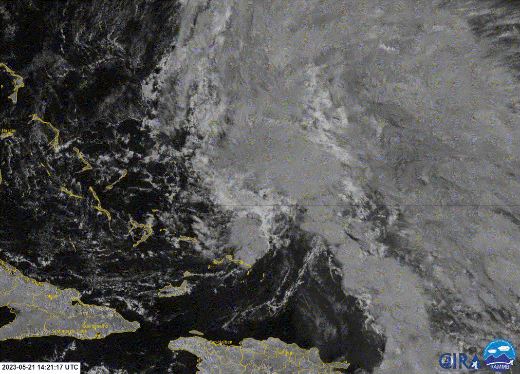
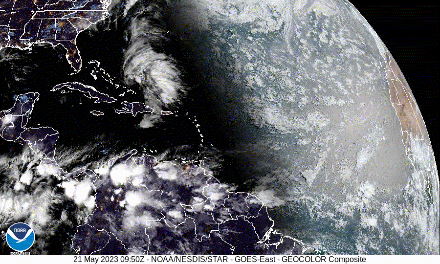
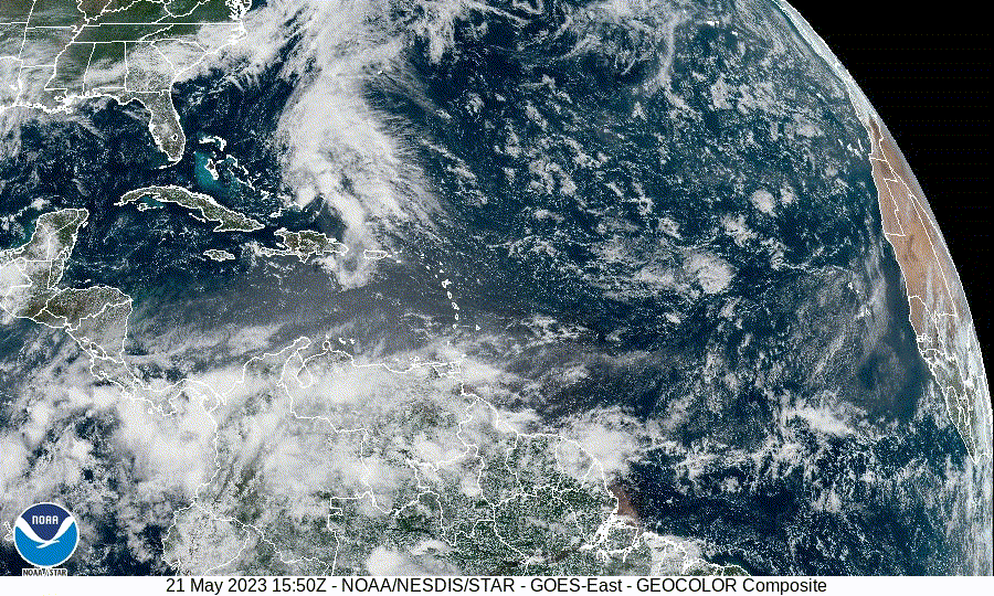
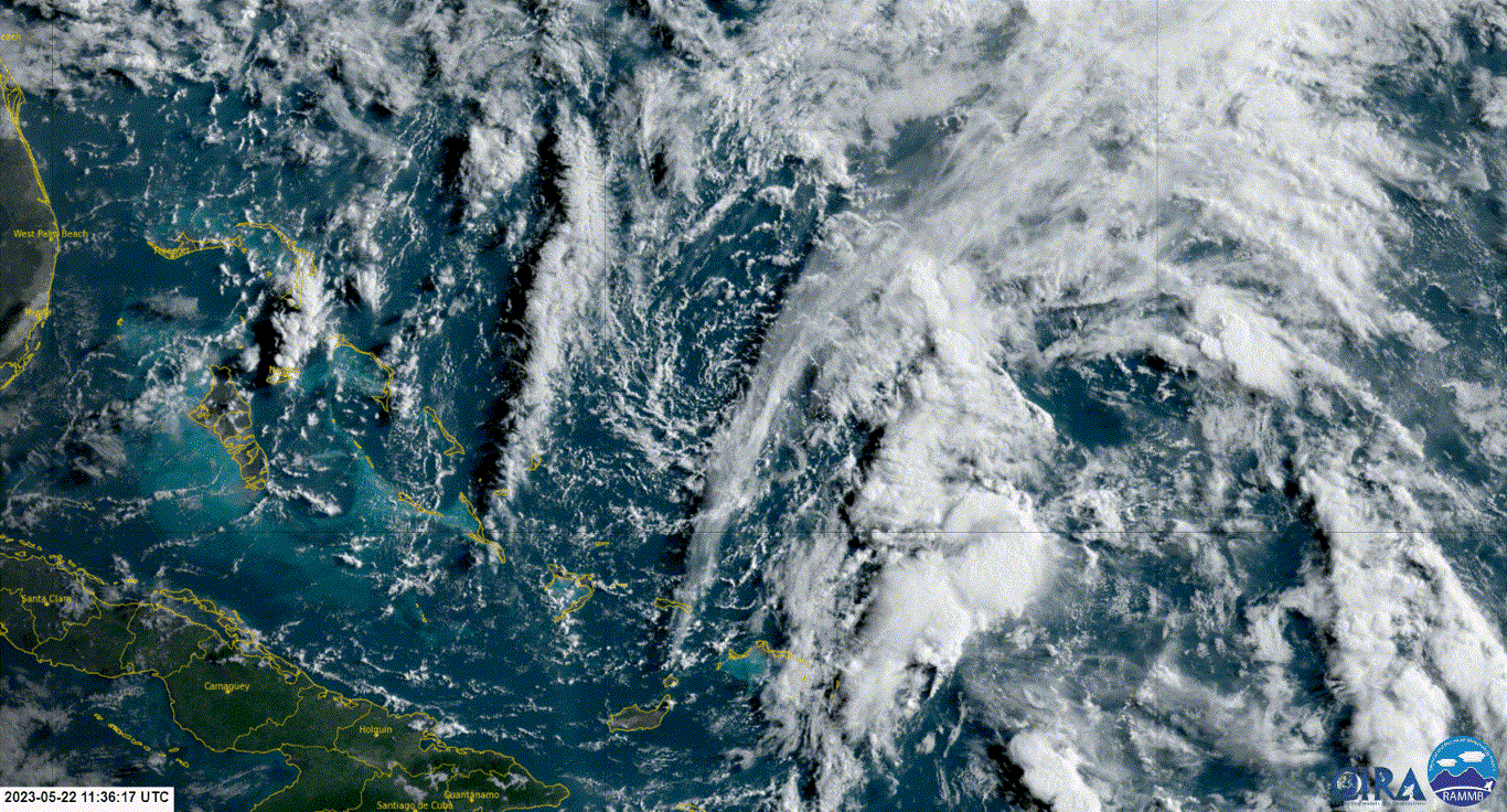
A surface trough interacting with an upper-level low is producing a
large area of disturbed weather extending a couple hundred miles
northeast of the Bahamas. Upper-level winds are expected to
increase later today and development of this system is not expected.
* Formation chance through 48 hours...low...10 percent.
* Formation chance through 7 days...low...10 percent.
$$
Forecaster Kelly/Bucci
![Image](https://i.imgur.com/Bk5W4Dp.png)
2 likes
Visit the Caribbean-Central America Weather Thread where you can find at first post web cams,radars
and observations from Caribbean basin members
Click Here
-
Category5Kaiju
- Category 5
![Category 5 Category 5](./images/ranks/cane8.gif)
- Posts: 3438
- Age: 22
- Joined: Thu Dec 24, 2020 12:45 pm
- Location: Seattle
#2 Postby Category5Kaiju » Sun May 21, 2023 7:06 am
![Image](https://media.tenor.com/QPPFQJC9SA8AAAAd/lizard-no-way-home.gif)
Not very surprising in all seriousness, many early-season storms take a similar path as what this one looks to do
0 likes
Unless explicitly stated, all information covered in my posts is based on my opinions and observations. Please refer to a professional meteorologist or an accredited weather research agency otherwise, especially if serious decisions must be made in the event of a potentially life-threatening tropical storm or hurricane.
-
AlanSnyder35
- Tropical Low
![Tropical Low Tropical Low](./images/ranks/cane1.gif)
- Posts: 21
- Joined: Sat Apr 22, 2023 2:41 pm
#3 Postby AlanSnyder35 » Sun May 21, 2023 8:13 am
The only problem this thing has is time, Conditions are decent right now. But 24 to 36 hours from now... not so much.
0 likes
-
ChrisH-UK
- Category 1
![Category 1 Category 1](./images/ranks/cane4.gif)
- Posts: 430
- Joined: Sat May 29, 2021 8:22 am
#4 Postby ChrisH-UK » Sun May 21, 2023 11:14 am
Using the snow/ice band from GOES-16, they lower white clouds show the circulation, the grey higher clouds are not wrapping up yet
Source -
https://col.st/OVROD![Image](https://imagizer.imageshack.com/img922/2640/SiI63C.gif)
3 likes
-
zzzh
- Category 2
![Category 2 Category 2](./images/ranks/cane5.gif)
- Posts: 560
- Joined: Thu Sep 02, 2021 1:13 pm
#5 Postby zzzh » Sun May 21, 2023 12:03 pm
2 likes
-
cycloneye
- Admin
![Admin Admin](./images/ranks/admin2.png)
- Posts: 139600
- Age: 67
- Joined: Thu Oct 10, 2002 10:54 am
- Location: San Juan, Puerto Rico
#6 Postby cycloneye » Sun May 21, 2023 12:34 pm
Tropical Weather Outlook
NWS National Hurricane Center Miami FL
200 PM EDT Sun May 21 2023
For the North Atlantic...Caribbean Sea and the Gulf of Mexico:
1. Southwestern Tropical Atlantic:
A broad low is producing a large area of disturbed weather extending
a couple hundred miles northeast of the Bahamas. Environmental
conditions are expected to become less favorable later today and
development of this system is not expected as it moves generally
north-northeastward over the southwestern Atlantic at 5 to 10 mph
during the next couple of days.
* Formation chance through 48 hours...low...10 percent.
* Formation chance through 7 days...low...10 percent.
$$
Forecaster Kelly/Bucci
0 likes
Visit the Caribbean-Central America Weather Thread where you can find at first post web cams,radars
and observations from Caribbean basin members
Click Here
-
Sciencerocks
- Category 5
![Category 5 Category 5](./images/ranks/cane8.gif)
- Posts: 7300
- Age: 38
- Joined: Thu Jul 06, 2017 1:51 am
#7 Postby Sciencerocks » Sun May 21, 2023 1:27 pm
Looks pretty good....Appears at least on visible to be at least a LLC with some convection near the area the ascat shown a closed cirulation. Maybe this doesn't form in its own right but it could help form something further west as the gfs, cmc and ecmwf has been suggesting over the past few days.
![Image](https://imagizer.imageshack.com/img923/8975/xHgYlh.gif)
2 likes
-
JetFuel_SE
- Category 1
![Category 1 Category 1](./images/ranks/cane4.gif)
- Posts: 279
- Age: 24
- Joined: Thu Apr 30, 2020 3:57 pm
#8 Postby JetFuel_SE » Sun May 21, 2023 3:46 pm
Sciencerocks wrote:Looks pretty good....Appears at least on visible to be at least a LLC with some convection near the area the ascat shown a closed cirulation. Maybe this doesn't form in its own right but it could help form something further west as the gfs, cmc and ecmwf has been suggesting over the past few days.
https://imagizer.imageshack.com/img923/8975/xHgYlh.gif
Along with everyone's favorite model that is in dire need of replacement.
![Image](https://cdn.discordapp.com/attachments/736018608366551111/1109942303327535134/navgem_mslp_pcpn_eus_fh6-180.gif)
0 likes
-
AlanSnyder35
- Tropical Low
![Tropical Low Tropical Low](./images/ranks/cane1.gif)
- Posts: 21
- Joined: Sat Apr 22, 2023 2:41 pm
#9 Postby AlanSnyder35 » Sun May 21, 2023 3:55 pm
We sure that thing that forms to the west of it Isn't frontal ?
0 likes
-
cycloneye
- Admin
![Admin Admin](./images/ranks/admin2.png)
- Posts: 139600
- Age: 67
- Joined: Thu Oct 10, 2002 10:54 am
- Location: San Juan, Puerto Rico
#10 Postby cycloneye » Sun May 21, 2023 6:30 pm
Tropical Weather Outlook
NWS National Hurricane Center Miami FL
800 PM EDT Sun May 21 2023
For the North Atlantic...Caribbean Sea and the Gulf of Mexico:
1. Southwestern Tropical Atlantic:
A broad surface low centered a couple hundred miles northeast of the
central Bahamas is producing disorganized showers and thunderstorms
primarily east of its center. Environmental conditions are forecast
to become less favorable, and development of this system is not
expected as it moves generally north-northeastward at 5 to 10 mph
over the southwestern Atlantic during the next couple of days.
* Formation chance through 48 hours...low...10 percent.
* Formation chance through 7 days...low...10 percent.
Forecaster Papin/Blake
0 likes
Visit the Caribbean-Central America Weather Thread where you can find at first post web cams,radars
and observations from Caribbean basin members
Click Here
-
Sciencerocks
- Category 5
![Category 5 Category 5](./images/ranks/cane8.gif)
- Posts: 7300
- Age: 38
- Joined: Thu Jul 06, 2017 1:51 am
#11 Postby Sciencerocks » Sun May 21, 2023 7:30 pm
Looking at the models I am leaning towards this system developing and possibly being around for the next 168-190 hours just off the coast or making landfall between north carolina and New york....I'd go with 20% next 48 hours and 50% next 7 days.
![Image](https://imagizer.imageshack.com/img922/6559/y3llhQ.gif)
2 likes
-
AlanSnyder35
- Tropical Low
![Tropical Low Tropical Low](./images/ranks/cane1.gif)
- Posts: 21
- Joined: Sat Apr 22, 2023 2:41 pm
#12 Postby AlanSnyder35 » Sun May 21, 2023 7:51 pm
Sciencerocks wrote:Looking at the models I am leaning towards this system developing and possibly being around for the next 168-190 hours just off the coast or making landfall between north carolina and New york....I'd go with 20% next 48 hours and 50% next 7 days.
https://imagizer.imageshack.com/img922/6559/y3llhQ.gif
That thing near the Bahamas isn't the east coast thing, The main of this system is going up to the right, BUT a small piece may help from the east coast thing.
1 likes
-
cycloneye
- Admin
![Admin Admin](./images/ranks/admin2.png)
- Posts: 139600
- Age: 67
- Joined: Thu Oct 10, 2002 10:54 am
- Location: San Juan, Puerto Rico
#13 Postby cycloneye » Mon May 22, 2023 8:26 am
Tropical Weather Outlook
NWS National Hurricane Center Miami FL
800 AM EDT Mon May 22 2023
For the North Atlantic...Caribbean Sea and the Gulf of Mexico:
1. Southwestern Atlantic:
Showers and a few thunderstorms associated with a broad area of low
pressure located a couple of hundred miles northeast of the central
Bahamas remain poorly organized. Strong upper-level winds and dry
air are expected to prevent development while the system moves
generally north-northeastward at 5 to 10 mph over the southwestern
Atlantic during the next day or so.
* Formation chance through 48 hours...low...10 percent.
* Formation chance through 7 days...low...10 percent.
Forecaster Brown/Bucci
0 likes
Visit the Caribbean-Central America Weather Thread where you can find at first post web cams,radars
and observations from Caribbean basin members
Click Here
-
wxman57
- Moderator-Pro Met
![Moderator-Pro Met Moderator-Pro Met](./images/ranks/SenorPepr.png)
- Posts: 22506
- Age: 66
- Joined: Sat Jun 21, 2003 8:06 pm
- Location: Houston, TX (southwest)
#15 Postby wxman57 » Mon May 22, 2023 8:51 am
Weak swirl in a high shear environment. Should slowly weaken as it tracks northeast. Second low may form on the front off the S. Carolina coast Fri/Sat then move inland into North Carolina and Virginia on Sunday. Slim chance it will be classified as a depression.
0 likes
-
cycloneye
- Admin
![Admin Admin](./images/ranks/admin2.png)
- Posts: 139600
- Age: 67
- Joined: Thu Oct 10, 2002 10:54 am
- Location: San Juan, Puerto Rico
#16 Postby cycloneye » Mon May 22, 2023 12:44 pm
0%.
Tropical Weather Outlook
NWS National Hurricane Center Miami FL
200 PM EDT Mon May 22 2023
For the North Atlantic...Caribbean Sea and the Gulf of Mexico:
Southwestern Atlantic:
Disorganized showers and a few thunderstorms associated with a broad
area of low pressure located a couple of hundred miles northeast of
the central Bahamas have decreased since yesterday. Environmental
conditions have become more hostile and development of this system
is not expected while it moves north-northeastward at 5 to 10 mph
over the southwestern Atlantic during the next day or so.
* Formation chance through 48 hours...low...near 0 percent.
* Formation chance through 7 days...low...near 0 percent.
$$
Forecaster Brown/Bucci
0 likes
Visit the Caribbean-Central America Weather Thread where you can find at first post web cams,radars
and observations from Caribbean basin members
Click Here
-
DorkyMcDorkface
- Category 2
![Category 2 Category 2](./images/ranks/cane5.gif)
- Posts: 743
- Age: 26
- Joined: Mon Sep 30, 2019 1:32 pm
- Location: Mid-Atlantic
#17 Postby DorkyMcDorkface » Mon May 22, 2023 1:43 pm
Never had a shot really, even though there is a surface low convective activity has remained disorganized and conditions will only deteriorate from here. Think we can close the book on this one.
0 likes
Floyd 1999 | Isabel 2003 | Hanna 2008 | Irene 2011 | Sandy 2012 | Isaias 2020
-
AJC3
- Admin
![Admin Admin](./images/ranks/admin2.png)
- Posts: 3887
- Age: 60
- Joined: Tue Aug 31, 2004 7:04 pm
- Location: West Melbourne, Florida
-
Contact:
#18 Postby AJC3 » Tue May 23, 2023 1:53 am
ZCZC MIATWOAT ALL
TTAA00 KNHC DDHHMM
Tropical Weather Outlook
NWS National Hurricane Center Miami FL
200 AM EDT Tue May 23 2023
For the North Atlantic...Caribbean Sea and the Gulf of Mexico:
Tropical cyclone formation is not expected during the next 7 days.
$$
Forecaster Papin
NNNN
0 likes
Return to “Talkin' Tropics”
Who is online
Users browsing this forum: CFLHurricane, crownweather, Cutt, duilaslol, Google [Bot], Google Adsense [Bot], HurricaneA, Hurricaneman, Jr0d, KirbyDude25, lolitx, skyline385, TheAustinMan, Tireman4, Tx_Summer, Wampadawg, zzzh and 113 guests