Low Pressure Inland over the Southern U.S.
Moderator: S2k Moderators
Forum rules

The posts in this forum are NOT official forecasts and should not be used as such. They are just the opinion of the poster and may or may not be backed by sound meteorological data. They are NOT endorsed by any professional institution or STORM2K. For official information, please refer to products from the National Hurricane Center and National Weather Service.
-
Dean4Storms
- S2K Supporter

- Posts: 6358
- Age: 63
- Joined: Sun Aug 31, 2003 1:01 pm
- Location: Miramar Bch. FL
Re: Low Pressure in the northern Gulf of Mexico
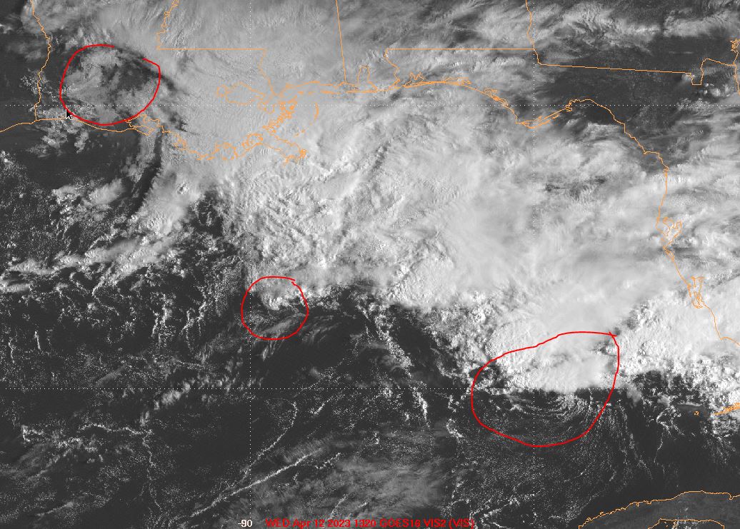
Very evident LLC to the WNW of the Keys moving northward. These Hi-Res CAMS sure do deepen this more than the globals.
0 likes
-
cycloneye

- Admin

- Posts: 149727
- Age: 69
- Joined: Thu Oct 10, 2002 10:54 am
- Location: San Juan, Puerto Rico
Re: Low Pressure in the northern Gulf of Mexico
25N-84.5W.

1 likes
Visit the Caribbean-Central America Weather Thread where you can find at first post web cams,radars
and observations from Caribbean basin members Click Here
and observations from Caribbean basin members Click Here
-
Hypercane_Kyle

- Category 5

- Posts: 3465
- Joined: Sat Mar 07, 2015 7:58 pm
- Location: Cape Canaveral, FL
Re: Low Pressure in the northern Gulf of Mexico
While I think the low will ultimately be a non-tropical one, I think it's fair to expect TS like conditions in LA the next few days.
1 likes
My posts are my own personal opinion, defer to the National Hurricane Center (NHC) and other NOAA products for decision making during hurricane season.
-
Dean4Storms
- S2K Supporter
- Posts: 6358
- Age: 63
- Joined: Sun Aug 31, 2003 1:01 pm
- Location: Miramar Bch. FL
-
Dean4Storms
- S2K Supporter
- Posts: 6358
- Age: 63
- Joined: Sun Aug 31, 2003 1:01 pm
- Location: Miramar Bch. FL
Re: Low Pressure in the northern Gulf of Mexico
I know a bit off topic, but everyone aware of this?
"Coming soon: An updated and mobile-friendly version of the NDBC website with a look similar to other NWS sites will be launching on April 19, 2023."
"Coming soon: An updated and mobile-friendly version of the NDBC website with a look similar to other NWS sites will be launching on April 19, 2023."
1 likes
-
wxman57

- Moderator-Pro Met

- Posts: 23175
- Age: 68
- Joined: Sat Jun 21, 2003 8:06 pm
- Location: Houston, TX (southwest)
Re: Low Pressure in the northern Gulf of Mexico
Dean4Storms wrote:Very evident LLC to the WNW of the Keys moving northward. These Hi-Res CAMS sure do deepen this more than the globals.
That's just one of several swirls along the frontal boundary. Main low is forming south of SE LA. Completely frontal. Dewpoints in the low 60s offshore.
4 likes
-
cycloneye
- Admin
- Posts: 149727
- Age: 69
- Joined: Thu Oct 10, 2002 10:54 am
- Location: San Juan, Puerto Rico
Re: Low Pressure in the northern Gulf of Mexico

2 likes
Visit the Caribbean-Central America Weather Thread where you can find at first post web cams,radars
and observations from Caribbean basin members Click Here
and observations from Caribbean basin members Click Here
-
wxman57
- Moderator-Pro Met
- Posts: 23175
- Age: 68
- Joined: Sat Jun 21, 2003 8:06 pm
- Location: Houston, TX (southwest)
Re: Low Pressure in the northern Gulf of Mexico
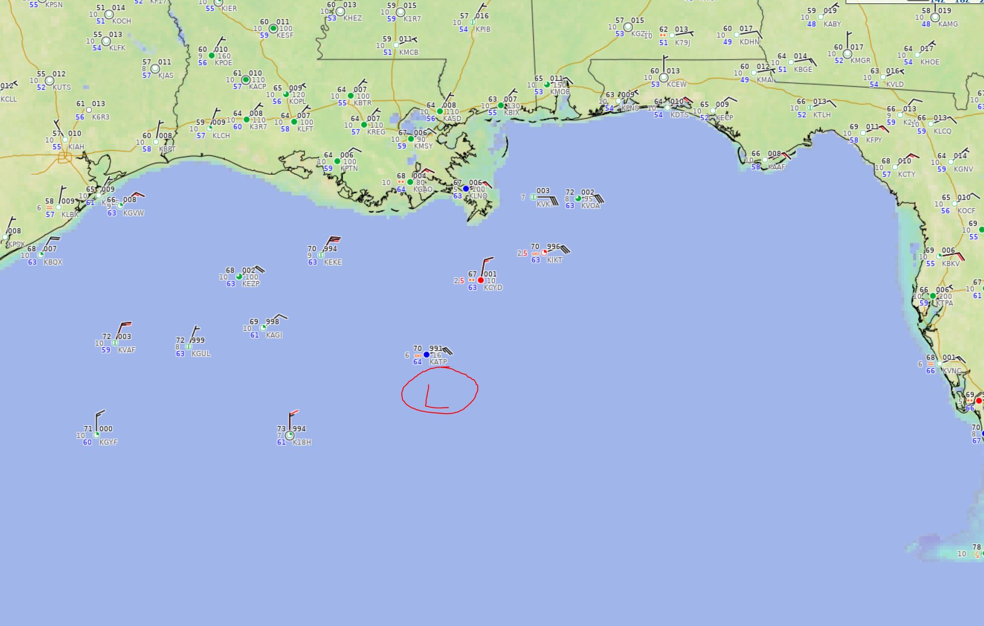
Here's a surface map. Low is forming just south of KATP, a deepwater platform in Walker Ridge.
2 likes
-
Aric Dunn
- Category 5
- Posts: 21238
- Age: 43
- Joined: Sun Sep 19, 2004 9:58 pm
- Location: Ready for the Chase.
- Contact:
Re: Low Pressure in the northern Gulf of Mexico
Several meso vorts as was expected and shown with models initially this morning. As the upper lowmover western LA shifts the shear will continue to turn out of the south and become more divergent. Should get a consolidated LLC in the central gulf by this evening. As it starts the move with the shear it will have its best shot.
4 likes
Note: If I make a post that is brief. Please refer back to previous posts for the analysis or reasoning. I do not re-write/qoute what my initial post said each time.
If there is nothing before... then just ask
Space & Atmospheric Physicist, Embry-Riddle Aeronautical University,
I believe the sky is falling...
If there is nothing before... then just ask
Space & Atmospheric Physicist, Embry-Riddle Aeronautical University,
I believe the sky is falling...

-
cycloneye
- Admin
- Posts: 149727
- Age: 69
- Joined: Thu Oct 10, 2002 10:54 am
- Location: San Juan, Puerto Rico
Re: Low Pressure in the northern Gulf of Mexico
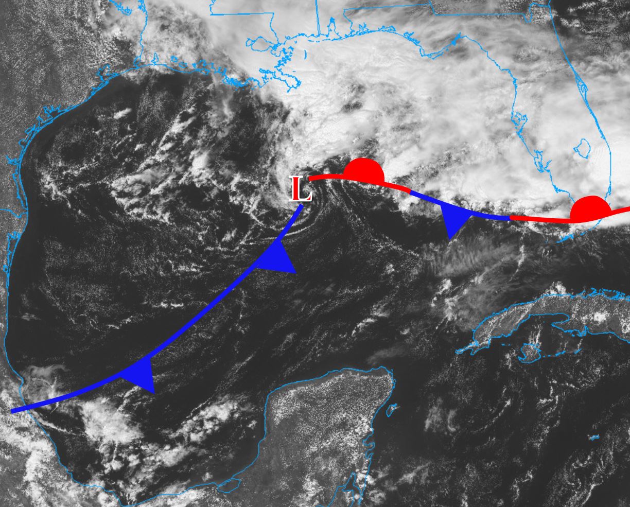
The 12z surface analysis placed the main low there.

6 likes
Visit the Caribbean-Central America Weather Thread where you can find at first post web cams,radars
and observations from Caribbean basin members Click Here
and observations from Caribbean basin members Click Here
-
cycloneye
- Admin
- Posts: 149727
- Age: 69
- Joined: Thu Oct 10, 2002 10:54 am
- Location: San Juan, Puerto Rico
Re: Low Pressure in the northern Gulf of Mexico
The synopsis of the area.
Synopsis for the Gulf of Mexico
1110 AM EDT Wed Apr 12 2023
.SYNOPSIS...A 1010 mb low pres has developed over the central Gulf
near 26N89W, with a stationary front extending ESE to the Florida
Keys. Strong to near gale force E winds, with gusts to gale
force, are observed in the NE semicircle of the low. These strong
to gale force winds will continue over the NE and north-central
Gulf through tonight as the low moves N. The low will move inland
over the U.S. north-central Gulf Coast on Thu. Once the low moves
inland, marine conditions will improve Thu afternoon and evening.
For the weekend, a cold front is forecast to enter the western
Gulf which will cause winds and seas to increase.
0 likes
Visit the Caribbean-Central America Weather Thread where you can find at first post web cams,radars
and observations from Caribbean basin members Click Here
and observations from Caribbean basin members Click Here
-
wxman57
- Moderator-Pro Met
- Posts: 23175
- Age: 68
- Joined: Sat Jun 21, 2003 8:06 pm
- Location: Houston, TX (southwest)
Re: Low Pressure in the northern Gulf of Mexico
That analysis should have a cold front extending SW from the low to the northern Bay of Campeche. We (Texas coast) are definitely not in maritime-tropical air, we're in modified Canadian-Polar air, which means that there is a cold front across the Gulf to our south. Front is south of Tampico, MX but north of Veracruz.
I think that the HRRR is way too strong with the low, trying to develop a tropical core in a high wind shear environment. Wind 30-35 kts north of the low and frontal system looks more reasonable.
3 likes
-
cycloneye
- Admin
- Posts: 149727
- Age: 69
- Joined: Thu Oct 10, 2002 10:54 am
- Location: San Juan, Puerto Rico
Re: Low Pressure in the northern Gulf of Mexico
0 likes
Visit the Caribbean-Central America Weather Thread where you can find at first post web cams,radars
and observations from Caribbean basin members Click Here
and observations from Caribbean basin members Click Here
-
wxman57
- Moderator-Pro Met
- Posts: 23175
- Age: 68
- Joined: Sat Jun 21, 2003 8:06 pm
- Location: Houston, TX (southwest)
Re: Low Pressure in the northern Gulf of Mexico
Current situation in the Gulf. All of the pressure gradient is north and northeast of the weak low center, between it and the strong high to the northeast.
0 likes
-
Stormcenter
- S2K Supporter
- Posts: 6689
- Joined: Wed Sep 03, 2003 11:27 am
- Location: Houston, TX
-
JetFuel_SE

- Category 1

- Posts: 288
- Age: 26
- Joined: Thu Apr 30, 2020 3:57 pm
Re: Low Pressure in the northern Gulf of Mexico
wxman57 wrote:Current situation in the Gulf. All of the pressure gradient is north and northeast of the weak low center, between it and the strong high to the northeast.
http://wxman57.com/images/GulfLow.JPG
Care to back that up with more than lines you drew on a satellite image? I really don't know where you're getting that "cold front" from.
2 likes
Re: Low Pressure in the northern Gulf of Mexico
Shear and helicity associated with that warm front are driving some severe storm activity in the Miami area. Tornado warning for Fort Lauderdale as I type this
0 likes
-
Aric Dunn
- Category 5
- Posts: 21238
- Age: 43
- Joined: Sun Sep 19, 2004 9:58 pm
- Location: Ready for the Chase.
- Contact:
Re: Low Pressure in the northern Gulf of Mexico
Here comes that tug north/reformation under the convection per the HRRR. should be interesting
3 likes
Note: If I make a post that is brief. Please refer back to previous posts for the analysis or reasoning. I do not re-write/qoute what my initial post said each time.
If there is nothing before... then just ask
Space & Atmospheric Physicist, Embry-Riddle Aeronautical University,
I believe the sky is falling...
If there is nothing before... then just ask
Space & Atmospheric Physicist, Embry-Riddle Aeronautical University,
I believe the sky is falling...
-
Dean4Storms
- S2K Supporter
- Posts: 6358
- Age: 63
- Joined: Sun Aug 31, 2003 1:01 pm
- Location: Miramar Bch. FL
Re: Low Pressure in the northern Gulf of Mexico
No matter how it unfolds according to most of the guidance there's going to be a strong enough gradient to produce TS force winds out over the Gulf and some rough seas, winds along the Coast to possibly 40mph and would not surprise me to see some close to 50mph. There's also that threat of Waterspouts and some moving ashore for a brief period of time as tornadoes.
3 likes
Who is online
Users browsing this forum: No registered users and 124 guests