
Iceresistance wrote:Remember that I said that the craziest models would try to go for 1080 mb Arctic HP? Well, the 12z JMA did just that.
31.9 inches of Mercury. There goes your barometer
Moderator: S2k Moderators
 The posts in this forum are NOT official forecast and should not be used as such. They are just the opinion of the poster and may or may not be backed by sound meteorological data. They are NOT endorsed by any professional institution or STORM2K.
Iceresistance wrote:Remember that I said that the craziest models would try to go for 1080 mb Arctic HP? Well, the 12z JMA did just that.


opticsguy wrote:Iceresistance wrote:Remember that I said that the craziest models would try to go for 1080 mb Arctic HP? Well, the 12z JMA did just that.
31.9 inches of Mercury. There goes your barometer


Brent wrote:Tulsa is already concerned and it's not even inside the forecast yet
The
increasing forecast focus will be on the potential for arctic air
spilling into the western and central CONUS mid to late next week.
Guidance expectantly varies greatly at this time range but the
potential for the cold air does warrant attention.

Iceresistance wrote:Brent wrote:Tulsa is already concerned and it's not even inside the forecast yet
The
increasing forecast focus will be on the potential for arctic air
spilling into the western and central CONUS mid to late next week.
Guidance expectantly varies greatly at this time range but the
potential for the cold air does warrant attention.
So is Norman!Cold temperatures should continue next week as a lobe of the polar
vortex drops into the Great Lakes and stagnates the pattern. There
appears to be a low-end signal for rain Sunday and Monday, with
perhaps more substantial chances for precipitation after the end of
the forecast period.

Texas Snowman wrote:Quixotic wrote:It will not be ‘83 again. I don’t think people appreciate just how long it was cold. That said, might want to start worrying about the grid again.
I certainly appreciate how cold it was and how long it was cold. I was a senior in high school that year. We tried to go duck hunting on Lake Texoma during that arctic outbreak and the ice was so thick in the shallow cove we were going to set our decoys in that myself and two grown men couldn’t even get it to crack.
orangeblood wrote:Pay attention to the core LP anomaly over Iowa in the Euro Ens Mean for late next week…if that begins to shift southwest over next several runs toward its operational, than this could get really serious with heavy precip and extreme cold. Otherwise, probably just a very cold/dry Christmas holiday
https://images.weatherbell.com/model/ecmwf-ensemble-avg/namer/z500_anom/1670932800/1671732000-DamQJG1zpe0.png
ThunderSleetDreams wrote:orangeblood wrote:Pay attention to the core LP anomaly over Iowa in the Euro Ens Mean for late next week…if that begins to shift southwest over next several runs toward its operational, than this could get really serious with heavy precip and extreme cold. Otherwise, probably just a very cold/dry Christmas holiday
https://images.weatherbell.com/model/ecmwf-ensemble-avg/namer/z500_anom/1670932800/1671732000-DamQJG1zpe0.png
Hmmmm... it already seems a bit east given that set up. Whew the hi-res portions of following this are going to get fun.
ThunderSleetDreams wrote:Iceresistance wrote:Brent wrote:Tulsa is already concerned and it's not even inside the forecast yet
The
increasing forecast focus will be on the potential for arctic air
spilling into the western and central CONUS mid to late next week.
Guidance expectantly varies greatly at this time range but the
potential for the cold air does warrant attention.
So is Norman!Cold temperatures should continue next week as a lobe of the polar
vortex drops into the Great Lakes and stagnates the pattern. There
appears to be a low-end signal for rain Sunday and Monday, with
perhaps more substantial chances for precipitation after the end of
the forecast period.
If there's one thing Sooners are good for, its Meteorology.
Iceresistance wrote:Is there anyone here living near Shreveport, LA? The city is under a PDS Tornado Warning

Portastorm wrote:South Texas Storms wrote:We're likely going to be seeing an extended period of time with temperatures below freezing across much of Texas around Christmas. Let's hope ERCOT is better prepared this time around. I've heard that they are, but I won't believe it until I see it. I definitely don't want to be without power for several days again with brutally cold temperatures. Not fun at all.
We had rolling blackouts here in East Tx and it sucked. Luckily we have a fireplace.
Agree 1000%! The February 2021 Snowpocalypse and not having water for a week (I was lucky to have power, ironically enough because I live near a water treatment plant) diminished my love of Arctic outbreaks into Texas. Sure hope the state's power grid holds.


weatherdude1108 wrote:wxman57 wrote:For those of you who live way up north in the Dallas-Ft. Worth area, here's what the 12Z GFS has in store for you. No precip, just cold dry air. Again, not my forecast just raw GFS data. Cold, but not historic cold. Sweater weather.
http://wxman57.com/images/DFWGFS12ZDec13.JPG
http://wxman57.com/images/DFWGFSX12ZDec13.JPG
Can you run one of these for Austin?


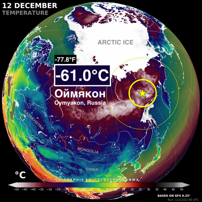
Scott Duncan
@ScottDuncanWX
Brutal.
The coldest permanently inhabited settlement on Earth, Oymyakon (Russia), just dropped to an unforgiving -61.0°C (-77.8°F).
One of the coldest moments in recorded history in this part pf the world for this early in the winter.
Iceresistance wrote:The Arctic HPs have trended weaker on 18z GFS compared to 12z GFS.
EDIT: Nevermind that! 1064 mb in SW Canada!?
ThunderSleetDreams wrote:Iceresistance wrote:The Arctic HPs have trended weaker on 18z GFS compared to 12z GFS.
EDIT: Nevermind that! 1064 mb in SW Canada!?
1065 and 1066 behind it.
Users browsing this forum: No registered users and 240 guests


