ATL: NICOLE - Post-Tropical - Discussion
Moderator: S2k Moderators
-
TreasureIslandFLGal

- S2K Supporter

- Posts: 1584
- Age: 58
- Joined: Sun Aug 15, 2004 6:16 pm
- Location: Cancun, Mexico (northeast Yucatan coast)
Re: ATL: NICOLE - Tropical Storm - Discussion
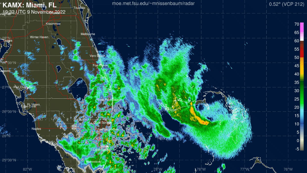
When will we see Nicole start hitting the Gulf Stream? It has to clear the Bahamian island to the north, correct, then right after it can start feeling the effects? --or does it run a bit closer to the Florida coastline?
0 likes
Chrissy & Ligeia

-
SFLcane

- S2K Supporter
- Posts: 10281
- Age: 48
- Joined: Sat Jun 05, 2010 1:44 pm
- Location: Lake Worth Florida
Re: ATL: NICOLE - Tropical Storm - Discussion
Thinking this might come in further south then all models showing we will see.
6 likes
-
eastcoastFL

- Category 5

- Posts: 3996
- Age: 44
- Joined: Thu Apr 12, 2007 12:29 pm
- Location: Palm City, FL
Re: ATL: NICOLE - Tropical Storm - Discussion
SFLcane wrote:Thinking this might come in further south then all models showing we will see.
Seems to be right on track for the time being. I just wonder how quick she will turn wnw and NW.
0 likes
Personal Forecast Disclaimer:
The posts in this forum are NOT official forecast and should not be used as such. They are just the opinion of the poster and may or may not be backed by sound meteorological data. They are NOT endorsed by any professional institution or storm2k.org. For official information, please refer to the NHC and NWS products.
The posts in this forum are NOT official forecast and should not be used as such. They are just the opinion of the poster and may or may not be backed by sound meteorological data. They are NOT endorsed by any professional institution or storm2k.org. For official information, please refer to the NHC and NWS products.
-
alienstorm

- Category 1

- Posts: 496
- Joined: Tue Jul 31, 2007 1:29 pm
- Location: Miami Fla western suburb
Re: ATL: NICOLE - Tropical Storm - Discussion
Seems to be heading a tab south 260-265 also western eyewall starting to generate.
0 likes
Personal Forecast Disclaimer:The posts in this forum are NOT official forecast and should not be used as such. They are just the opinion of the poster and may or may not be backed by sound meteorological data. They are NOT endorsed by any professional institution or storm2k.org. For official information, please refer to the NHC and NWS products.
-
tolakram
- Admin

- Posts: 20186
- Age: 62
- Joined: Sun Aug 27, 2006 8:23 pm
- Location: Florence, KY (name is Mark)
Re: ATL: NICOLE - Tropical Storm - Discussion
saved loop

0 likes
M a r k
- - - - -
Join us in chat: Storm2K Chatroom Invite. Android and IOS apps also available.
The posts in this forum are NOT official forecasts and should not be used as such. Posts are NOT endorsed by any professional institution or STORM2K.org. For official information and forecasts, please refer to NHC and NWS products.
-
TheHurricaneGod
- Tropical Storm

- Posts: 165
- Age: 23
- Joined: Thu Apr 16, 2020 6:19 pm
- Location: Fort Lauderdale
Re: ATL: NICOLE - Tropical Storm - Discussion
it does seem like it wobbled south a little, based on the radar. the southern eyewall has lost a little bit of latitude
1 likes
-
jlauderdal
- S2K Supporter
- Posts: 7240
- Joined: Wed May 19, 2004 5:46 am
- Location: NE Fort Lauderdale
- Contact:
Re: RE: Re: ATL: NICOLE - Tropical Storm - Discussion
Wpb landfall is in the cardsSFLcane wrote:Thinking this might come in further south then all models showing we will see.
3 likes
-
AutoPenalti
- Category 5
- Posts: 4091
- Age: 29
- Joined: Mon Aug 17, 2015 4:16 pm
- Location: Ft. Lauderdale, Florida
Re: ATL: NICOLE - Tropical Storm - Discussion
It's extremely hard for models to nail down an exact landfall within 24 hours. So at this point it's real time tracking.
3 likes
The posts in this forum are NOT official forecasts and should not be used as such. They are just the opinion of the poster and may or may not be backed by sound meteorological data. They are NOT endorsed by any professional institution or STORM2K. For official information, please refer to products from the NHC and NWS.
Model Runs Cheat Sheet:
GFS (5:30 AM/PM, 11:30 AM/PM)
HWRF, GFDL, UKMET, NAVGEM (6:30-8:00 AM/PM, 12:30-2:00 AM/PM)
ECMWF (1:45 AM/PM)
TCVN is a weighted averaged
Re: ATL: NICOLE - Tropical Storm - Discussion
tolakram wrote:saved loop
https://i.imgur.com/rnwTljs.gif
wow that’s a great loop is that a ongoing loop live..?
0 likes
Re: ATL: NICOLE - Tropical Storm - Discussion
As long as she is near the E tip of Grand Bahama Island at the 4PM advisory, she wouldn't be tracking south of any of the models.
0 likes
Personal Forecast Disclaimer:
The posts in this forum are NOT official forecasts and should not be used as such. They are just the opinion of the poster and may or may not be backed by sound meteorological data. They are NOT endorsed by any professional institution or storm2k.org. For official information, please refer to the NHC and NWS products.
The posts in this forum are NOT official forecasts and should not be used as such. They are just the opinion of the poster and may or may not be backed by sound meteorological data. They are NOT endorsed by any professional institution or storm2k.org. For official information, please refer to the NHC and NWS products.
-
typhoonty
- Tropical Storm
- Posts: 121
- Age: 31
- Joined: Wed May 31, 2017 10:37 pm
- Location: Fort Myers / Tallahassee, FL
- Contact:
Re: ATL: NICOLE - Tropical Storm - Discussion
Hate to say it, models are pretty useless at this point. Most models init'ed this going north of Marsh Harbour by a bit. 25 nm error at init. Who knows the downstream effects. The average error a day out is about 40 miles.
Take it from someone who had to live through the fallout of Ian. Everyone from SR 80 north should be preparing like the eye will come over your house, and then be happy when the eye (hopefully) passes north of your location.
Take it from someone who had to live through the fallout of Ian. Everyone from SR 80 north should be preparing like the eye will come over your house, and then be happy when the eye (hopefully) passes north of your location.
4 likes
FSU Meteorology student, opinions are mine, 20 years experience covering TC's, consult NHC/Local officials when making decisions.
Gabrielle '01, Michelle '01, Charley '04, Frances '04, Dennis '05, Katrina '05, Rita '05, Wilma '05, Fay '08, Isaac '12 Hermine '16, Irma '17, Michael '18, Eta '20, Elsa '21, IAN '22, Idalia '23, Debby '24, Helene '24
Gabrielle '01, Michelle '01, Charley '04, Frances '04, Dennis '05, Katrina '05, Rita '05, Wilma '05, Fay '08, Isaac '12 Hermine '16, Irma '17, Michael '18, Eta '20, Elsa '21, IAN '22, Idalia '23, Debby '24, Helene '24
-
StormingB81

- S2K Supporter
- Posts: 5676
- Age: 44
- Joined: Thu Aug 27, 2009 1:45 am
- Location: Rockledge, Florida
Re: ATL: NICOLE - Tropical Storm - Discussion
WESH and WFTV (Orlando stations) “in house” models showing landfall closer to Brevard. It’s worth noting their models sniffed out Ian’s progress before the models even with the track across the state south of what was forecasted.
2 likes
-
Poonwalker
- Category 1
- Posts: 270
- Joined: Tue Sep 20, 2022 11:12 am
Re: ATL: NICOLE - Tropical Storm - Discussion
TreasureIslandFLGal wrote:When will we see Nicole start hitting the Gulf Stream? It has to clear the Bahamian island to the north, correct, then right after it can start feeling the effects? --or does it run a bit closer to the Florida coastline?
It about to tap into it right now. Going from about 40J OHC (due to depth) to about 80J and stays there all the way across. Starts right around Grand Bahama exit
Last edited by Poonwalker on Wed Nov 09, 2022 3:29 pm, edited 1 time in total.
1 likes
-
Coolcruiseman
- Tropical Depression

- Posts: 97
- Age: 52
- Joined: Wed Sep 21, 2022 8:10 pm
- Location: Melbourne, FL
Re: ATL: NICOLE - Tropical Storm - Discussion
StormingB81 wrote:WESH and WFTV (Orlando stations) “in house” models showing landfall closer to Brevard. It’s worth noting their models sniffed out Ian’s progress before the models even with the track across the state south of what was forecasted.
WFTV has been fairly consistent with that closer to Brevard call. It also sniffed out Ian exiting over Cape Canaveral before the big models.
0 likes

Re: ATL: NICOLE - Tropical Storm - Discussion
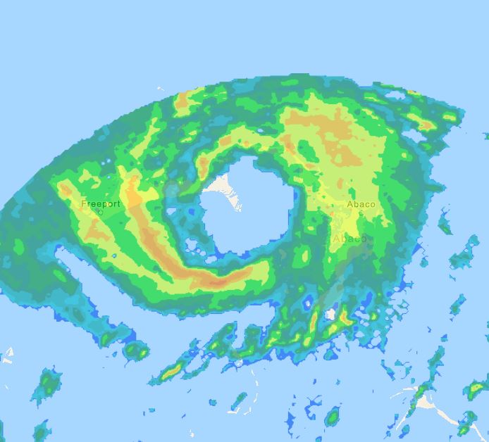
Be careful with the long range radar out of S FL, it is slightly tilted circulation.
Radar from Nassau shows it making landfall over the eastern tip of Grand Bahama Island, it looks to track to the north of Freeport.

Radar from Nassau shows it making landfall over the eastern tip of Grand Bahama Island, it looks to track to the north of Freeport.
2 likes
-
chris_fit

- Category 5
- Posts: 3261
- Age: 43
- Joined: Wed Sep 10, 2003 11:58 pm
- Location: Tampa Bay Area, FL
Re: ATL: NICOLE - Tropical Storm - Discussion
Coolcruiseman wrote:StormingB81 wrote:WESH and WFTV (Orlando stations) “in house” models showing landfall closer to Brevard. It’s worth noting their models sniffed out Ian’s progress before the models even with the track across the state south of what was forecasted.
WFTV has been fairly consistent with that closer to Brevard call. It also sniffed out Ian exiting over Cape Canaveral before the big models.
WFLA in Tampa also showing 'in house model' and it going further north into Indian River/Brevard Area - wonder if all their in house models are the same.
0 likes
-
wxman57

- Moderator-Pro Met

- Posts: 23175
- Age: 68
- Joined: Sat Jun 21, 2003 8:06 pm
- Location: Houston, TX (southwest)
Re: ATL: NICOLE - Tropical Storm - Discussion
StormingB81 wrote:WESH and WFTV (Orlando stations) “in house” models showing landfall closer to Brevard. It’s worth noting their models sniffed out Ian’s progress before the models even with the track across the state south of what was forecasted.
I doubt any TV station is running "in-house" models. With a storm that has such a large area of TS winds, the exact landfall point is less important. Any hurricane force winds may cover only a few square miles out over the water. Expect some strong tropical storm-force winds north of where the center reaches the coast. Beyond then, all that cool, dry air over Florida now will be flowing into Nicole, knocking its core down fairly quickly. Not a big rain producer. I see the latest EC forecasting only 2-3 inches across the eastern half of the Peninsula. This is no Ian. It'll be all gone by Friday afternoon. So ends the season (I hope).
6 likes
-
cycloneye

- Admin
- Posts: 149556
- Age: 69
- Joined: Thu Oct 10, 2002 10:54 am
- Location: San Juan, Puerto Rico
Re: ATL: NICOLE - Tropical Storm - Discussion
0 likes
Visit the Caribbean-Central America Weather Thread where you can find at first post web cams,radars
and observations from Caribbean basin members Click Here
and observations from Caribbean basin members Click Here
Who is online
Users browsing this forum: No registered users and 11 guests