ATL: NICOLE - Post-Tropical - Discussion
Moderator: S2k Moderators


Re: ATL: NICOLE - Subtropical Storm - Discussion
Nicole is building a proper nascent CDO right now. By far the coldest convection that's been associated with the center of the system is firing, and the hot towers have a distinctly cyclonic rotation. Signs of banding are also developing around the center, and the cloud cover is expanding to the South. This system is well on its way to transitioning to a hybrid type system with a warm core at the center of a broad subtropical fetch. Very interested in where recon pins the center.
3 likes
-
tropicwatch

- Category 5

- Posts: 3426
- Age: 62
- Joined: Sat Jun 02, 2007 10:01 am
- Location: The Villages, Florida
- Contact:
Re: ATL: NICOLE - Subtropical Storm - Discussion
Hasn't moved much. Looks a tad north of it previous position.
0 likes
Tropicwatch
Agnes 72', Eloise 75, Elena 85', Kate 85', Charley 86', Florence 88', Beryl 94', Dean 95', Erin 95', Opal 95', Earl 98', Georges 98', Ivan 2004', Arlene 2005', Dennis 2005', Ida 2009' Debby 2012' Irma 2017' Michael 2018'
Agnes 72', Eloise 75, Elena 85', Kate 85', Charley 86', Florence 88', Beryl 94', Dean 95', Erin 95', Opal 95', Earl 98', Georges 98', Ivan 2004', Arlene 2005', Dennis 2005', Ida 2009' Debby 2012' Irma 2017' Michael 2018'
-
Sciencerocks
- Category 5
- Posts: 10186
- Age: 40
- Joined: Thu Jul 06, 2017 1:51 am

Re: ATL: NICOLE - Subtropical Storm - Discussion
BobHarlem wrote:AutoPenalti wrote:Did Hurricane Watches switch to TS Warning for Broward?
Hurricane watches are up still, hurricane warnings will come later. The wind field ahead of it will get TS winds well ahead of the hurricane force winds. 4AM or more likely 10AM is when the Hurricane Warning area will likely get put up in some section of the tropical storm warning area. This all has to do with 36 vs 48 hour difference between watches/warnings. Wouldn't be surprised to see some Watches on the Florida west coast tomorrow too.
Here in the Big Bend the local forecast seems to show breezy and not much rain late this week. But 4 of the models seem to almost do a direct hit here. I realize the worst convection may be far away from any LLC or such. Anyone else get the impression from whats being reported/forecast that its heading more inland and missing any sizable impact on the big bend in the NHC info thus shown? I really expected more watches warnings and mention of surges and nasty weather for here, by now!
0 likes

Re: ATL: NICOLE - Subtropical Storm - Discussion
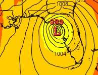
Buoy 41047 is down to 998.0mb and still dropping. Close to center.

1 likes
Re: ATL: NICOLE - Subtropical Storm - Discussion
Coolcruiseman wrote:eastcoastFL wrote:The track nudged a little north now to port at lucie.
That might change the impacts just a little for us to the north.
Also of note is that the NE turn occurs before Nicole has a chance to get in the GOM.
I see several models put her in the GOM before the NNE shift. I understand the idea of consensus, but how does one at this stage gauge how likely it will or will not hit the Gulf and maybe go onshore in Big Bend? I remember Irma got very strong 90-110 last couple hours in the warm waters up here.
Ie; I hate when NHC and all show a blend or consensus. I'd rather them show path A 25% chance B 50% chance C 25% chance when all 3 paths are still feasible, or is that just not possible with the technology or other issues?
0 likes
Re: ATL: NICOLE - Subtropical Storm - Discussion
rigbyrigz wrote:Coolcruiseman wrote:eastcoastFL wrote:The track nudged a little north now to port at lucie.
That might change the impacts just a little for us to the north.
Also of note is that the NE turn occurs before Nicole has a chance to get in the GOM.
I see several models put her in the GOM before the NNE shift. I understand the idea of consensus, but how does one at this stage gauge how likely it will or will not hit the Gulf and maybe go onshore in Big Bend? I remember Irma got very strong 90-110 last couple hours in the warm waters up here.
Ie; I hate when NHC and all show a blend or consensus. I'd rather them show path A 25% chance B 50% chance C 25% chance when all 3 paths are still feasible, or is that just not possible with the technology or other issues?
Just as illustration, appears (to me) latest GFS shows this:
...several other popular models shows something like this as well. Is it inaccurate to interpret this as some degree of likelihood that Nicole's center will be over water as it goes Northerly here?
Upd: Latest HWRF shows this as well.

Yeah i know how loco this may sound but if i were an NHC charter (and im not even a pup) i would have a path zoomed to Big Bend not inland, and a TSW?W up here soon too.
Last edited by rigbyrigz on Tue Nov 08, 2022 2:39 am, edited 1 time in total.
0 likes
Re: ATL: NICOLE - Subtropical Storm - Discussion
Buoy 41047 now down to 997.0mb and still dropping. Measuring around 21kt sustained winds so pressure could be slightly lower.
06z BT update has it at 996mb.

06z BT update has it at 996mb.
1 likes
-
weeniepatrol

- Category 5
- Posts: 1343
- Joined: Sat Aug 22, 2020 5:30 pm
- Location: WA State
Re: ATL: NICOLE - Subtropical Storm - Discussion
Landy wrote:Buoy 41047 is down to 998.0mb and still dropping. Close to center.
https://cdn.discordapp.com/attachments/877402829797621770/1039431136977367070/plot_wind_pres_6.png
Below 997mb now


0 likes
Re: ATL: NICOLE - Subtropical Storm - Discussion
Buoy is now down to 996.3mb with 19kt sustained winds.
0 likes
-
cycloneye

- Admin

- Posts: 149565
- Age: 69
- Joined: Thu Oct 10, 2002 10:54 am
- Location: San Juan, Puerto Rico
Re: ATL: NICOLE - Subtropical Storm - Discussion
More north the track now near Melbourne.

0 likes
Visit the Caribbean-Central America Weather Thread where you can find at first post web cams,radars
and observations from Caribbean basin members Click Here
and observations from Caribbean basin members Click Here

ATL: NICOLE - Models
So the 4am NHC cone has shifted up the coast a touch following the models and the high altitude G4 is in the storm finally to get upper air data into the models later today…and the board is on DST still…grin
1 likes

Re: ATL: NICOLE - Subtropical Storm - Discussion
I think recon will find that Nicole is transitioning into a tropical system, if not already.

1 likes
Re: ATL: NICOLE - Subtropical Storm - Discussion
Weird how the NHC's track is so far north of the GFS and Euro, I guess they are splitting the difference between them and the UKMET which is way north in New Smyrna Beach, the TVCN is north of Melbourne.
1 likes
-
SFLcane

- S2K Supporter

- Posts: 10281
- Age: 48
- Joined: Sat Jun 05, 2010 1:44 pm
- Location: Lake Worth Florida
Re: ATL: NICOLE - Subtropical Storm - Discussion
NDG wrote:
Weird how the NHC's track is so far north of the GFS and Euro, I guess they are splitting the difference between them and the UKMET which is way north in New Smyrna Beach, the TVCN is north of Melbourne.
I knew somehow the SFL shield would hold up. It’s really unbelievable to see every time. We should see minimal impacts here down here.
2 likes
Re: ATL: NICOLE - Subtropical Storm - Discussion
Had the NOAA jet flown in yet with upper air data?
0 likes
-
cycloneye
- Admin
- Posts: 149565
- Age: 69
- Joined: Thu Oct 10, 2002 10:54 am
- Location: San Juan, Puerto Rico
Re: ATL: NICOLE - Subtropical Storm - Discussion
caneman wrote:Had the NOAA jet flown in yet with upper air data?
Is flying right now.
1 likes
Visit the Caribbean-Central America Weather Thread where you can find at first post web cams,radars
and observations from Caribbean basin members Click Here
and observations from Caribbean basin members Click Here
-
cycloneye
- Admin
- Posts: 149565
- Age: 69
- Joined: Thu Oct 10, 2002 10:54 am
- Location: San Juan, Puerto Rico
Re: ATL: NICOLE - Subtropical Storm - Discussion
Looking more tropical.

2 likes
Visit the Caribbean-Central America Weather Thread where you can find at first post web cams,radars
and observations from Caribbean basin members Click Here
and observations from Caribbean basin members Click Here
Re: ATL: NICOLE - Subtropical Storm - Discussion
caneman wrote:Had the NOAA jet flown in yet with upper air data?
There's one right night sampling the atmosphere around Nicole.

1 likes

Re: ATL: NICOLE - Subtropical Storm - Discussion
Very clear sharp tropical low level pressure profile now so surface winds should start to pick up this morning.
Models trending further north with the track which will be good for Dade county and Tampa bay.
Some of the 00z models landfalling with pressures in the 970's on the east coast though so will see the usual shopping routine for space coast north.
Models trending further north with the track which will be good for Dade county and Tampa bay.
Some of the 00z models landfalling with pressures in the 970's on the east coast though so will see the usual shopping routine for space coast north.
1 likes
Who is online
Users browsing this forum: No registered users and 48 guests